North America is sitting on top of one of the most geologically wild and unpredictable canvases on the planet. From volcanic columns that look like they were stacked by giants, to ocean holes that seem to swallow the Pacific whole, this continent has been quietly hiding formations so strange they barely feel real. Honestly, you could spend years hiking national parks and still not scratch the surface of what’s out there.
What makes these places so captivating isn’t just their appearance. It’s the unimaginable timescales, the violent ancient forces, and the sheer accident of geology that left them behind for you to stumble across. Some require a lottery permit just to visit. Others barely have a road sign pointing the way. Let’s dive in and uncover twelve of the most jaw-dropping geological wonders this continent has tucked away.
1. The Wave, Arizona: Where Sandstone Flows Like a River
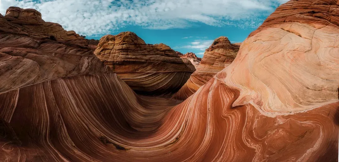
You’ve probably seen photos of it and assumed they were digitally edited. They weren’t. The Wave is a masterpiece of swirling sandstone, its once-horizontal layers twisted and turned into flowing ribbons of red, orange, and white. It sits within the Vermilion Cliffs National Monument, and it looks less like a rock formation and more like a frozen ocean wave captured mid-crash.
This undulating formation was shaped during the Jurassic period, when sand dunes were swept across the desert by wind, while the different-colored bands were created by chemicals left on the rock by water runoff. The result is one of the most photogenic and fragile geological sites in the entire country. Access is strictly regulated to protect this fragile wonder, with permits obtained through a lottery system months in advance. If you’re lucky enough to win that lottery, treat it like the privilege it is.
2. Devils Tower, Wyoming: The Monolith That Defies Easy Explanation
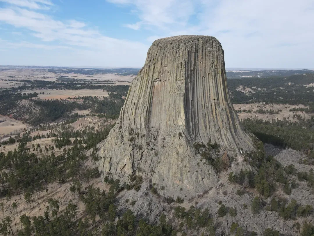
Rising like a colossal beacon from the Wyoming plains, Devils Tower is an imposing and mysterious sight. This monolithic giant has sparked wonder and debate for centuries, its sheer presence hinting at powerful forces both natural and spiritual. You can see it from miles away, a flat-topped column jutting straight out of rolling forest land like something from another world entirely.
For roughly 95 percent of its existence, the entire block lived belowground, formed by molten lava that welled up into a layer of sedimentary rock 50 million years ago. Starting about 1 or 2 million years ago, rain and snowmelt slowly washed away the surrounding sandstone, siltstone, and shale, leaving the much sturdier mass behind. Devils Tower holds immense cultural significance for many Native American tribes, including the Lakota, Kiowa, and Cheyenne. That is a fact worth sitting with before you reach for your climbing gear.
3. Thor’s Well, Oregon: The Drainpipe of the Pacific
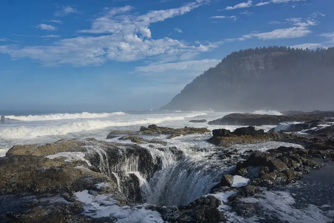
Imagine standing at the edge of the ocean and watching it get swallowed by the earth. That is the unsettling spectacle you get at Thor’s Well. Once considered one of Oregon’s great mysteries, Thor’s Well is a bowl-shaped hole carved into the basalt shoreline of Cape Perpetua, also known as the Drainpipe of the Pacific, and the seemingly bottomless well perpetually fills and drains throughout the day.
Once thought to be a giant sinkhole, researchers now believe that Thor’s Well in Oregon began as a large sea cave. The sea cave slowly formed over thousands of years as waves crashed into the volcanic rock that made up Cape Perpetua’s shoreline. It eventually collapsed, leaving a bowl-shaped hole just meters from shore. Despite its terrifying visual drama, the hole is only 20 feet deep. That fact somehow makes the whole thing feel even more theatrically deceptive.
4. Bryce Canyon Hoodoos, Utah: An Army of Stone Sentinels
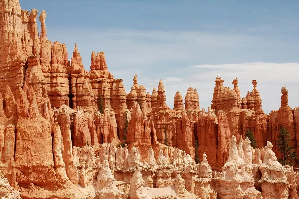
Here’s the thing about Bryce Canyon: it’s not actually a canyon. Bryce Canyon is a collection of giant natural amphitheaters in southwestern Utah, and it is distinctive due to geological structures called hoodoos, formed by frost weathering and stream erosion of the river and lake bed sedimentary rocks. Walking among them feels like wandering through the ruins of a civilization that never existed.
Home to the largest concentration of hoodoos on Earth, Bryce Canyon National Park is filled with a dizzying number of these majestic spires. Beginning around 50 million years ago, flat-lying rocks were deposited at the bottom of a river basin, then the uplifting of tectonic plates led to its higher elevation. Later, weathering and erosion broke down the surrounding rocks, leaving the unusual pillars we see today. Visit at sunrise if you possibly can. They look especially spectacular at sunrise and sunset, or under a fresh dusting of snowfall.
5. Devils Postpile, California: Geometry You Won’t Believe Nature Created
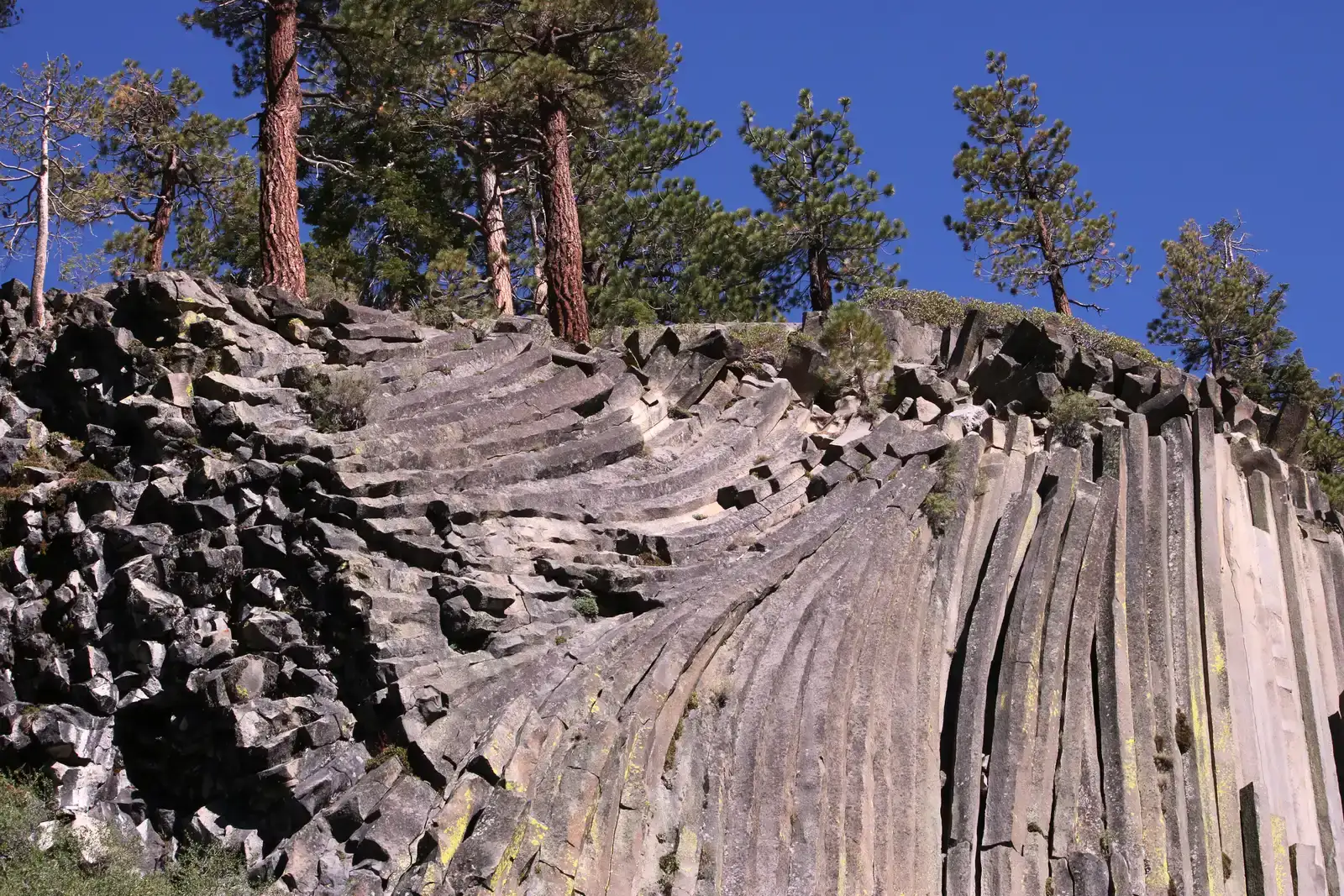
If someone showed you Devils Postpile in a photograph without context, you’d assume it was human-made architecture. The Devils Postpile is a cliff of columnar basalt, a type of rock formed by the rapid cooling of lava. These towers, some of which look as though they are lying on their side while others stand up to 18.3 meters tall, are closely packed together and share a rare degree of symmetry. This can be seen most easily by looking at the rock formation from above, where the density of the columns and their hexagonal shape soon become apparent.
The Devils Postpile began its life as a lake of lava around 80,000 to 100,000 years ago. A vent opened up in the Earth’s crust and began ejecting searing basaltic lava that flowed into the surrounding area. Eventually, the lava’s path was blocked by a natural dam, causing it to build up into an uncommonly deep lava lake. Devils Postpile National Monument, established in 1911, lies southeast of Yosemite National Park in the Sierra Nevada of California, and although a relatively small western national monument, it contains world-renowned examples of vertical columnar basalt.
6. Badlands, South Dakota: The Alien Terrain That Changes Every Rainstorm

The Badlands of South Dakota look like they belong on a different planet entirely. I think that’s not an exaggeration at all. Badlands contains some of the world’s most bizarre and alien-looking landscapes, classic examples of badland topography. The poorly consolidated bedrock, consisting of loose sediment and volcanic ash, is quickly eroded by infrequent rainstorms, and the resulting mud mounds, spires, and ridges resemble miniature mountain ranges.
Geological formations mixed with grass prairies inspired the Lakota Native American people, part of the Great Sioux Nation of the Midwest, to call this region mako sica, meaning “Badlands,” not only due to its terrain but also the lack of water and extreme temperatures. Over millions of years, Badlands drastically changed from a sea to a subtropical forest to an open savannah. Today, the old craggy rocks attract fossil hunters and hikers, and are an ideal location to spot wildlife such as prairie dogs and American bison. You won’t find many landscapes on Earth that pack quite so much prehistoric drama into one view.
7. Bowling Ball Beach, California: Nature’s Own Bowling Alley
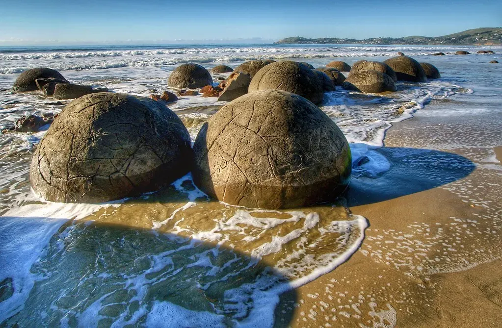
You’d be forgiven for thinking someone rolled hundreds of giant spherical boulders onto a Northern California beach as some kind of art installation. Located within Schooner Gulch State Beach in Mendocino, Bowling Ball Beach was named after the cluster of large round rocks that look like giant bowling balls hiding beneath its waves. These boulders are a rare geological phenomenon. The scene at low tide is surreal in the most wonderful way.
The mystical round rocks on Bowling Ball Beach are called concretions, or sedimentary rocks formed when minerals cement together within pore space. These bluffs were developed from the steeply dipping beds of the Miocene Galloway Formation during the Miocene Epoch, which occurred from 23 million to 5.3 million years ago. Crucially, the concretions of Bowling Ball Beach can only be seen at low tide, ideally at a minimum of minus 0.5 tide, and it’s advised to check the tide charts for optimal viewing.
8. Carlsbad Caverns, New Mexico: The Underworld Built by Acid
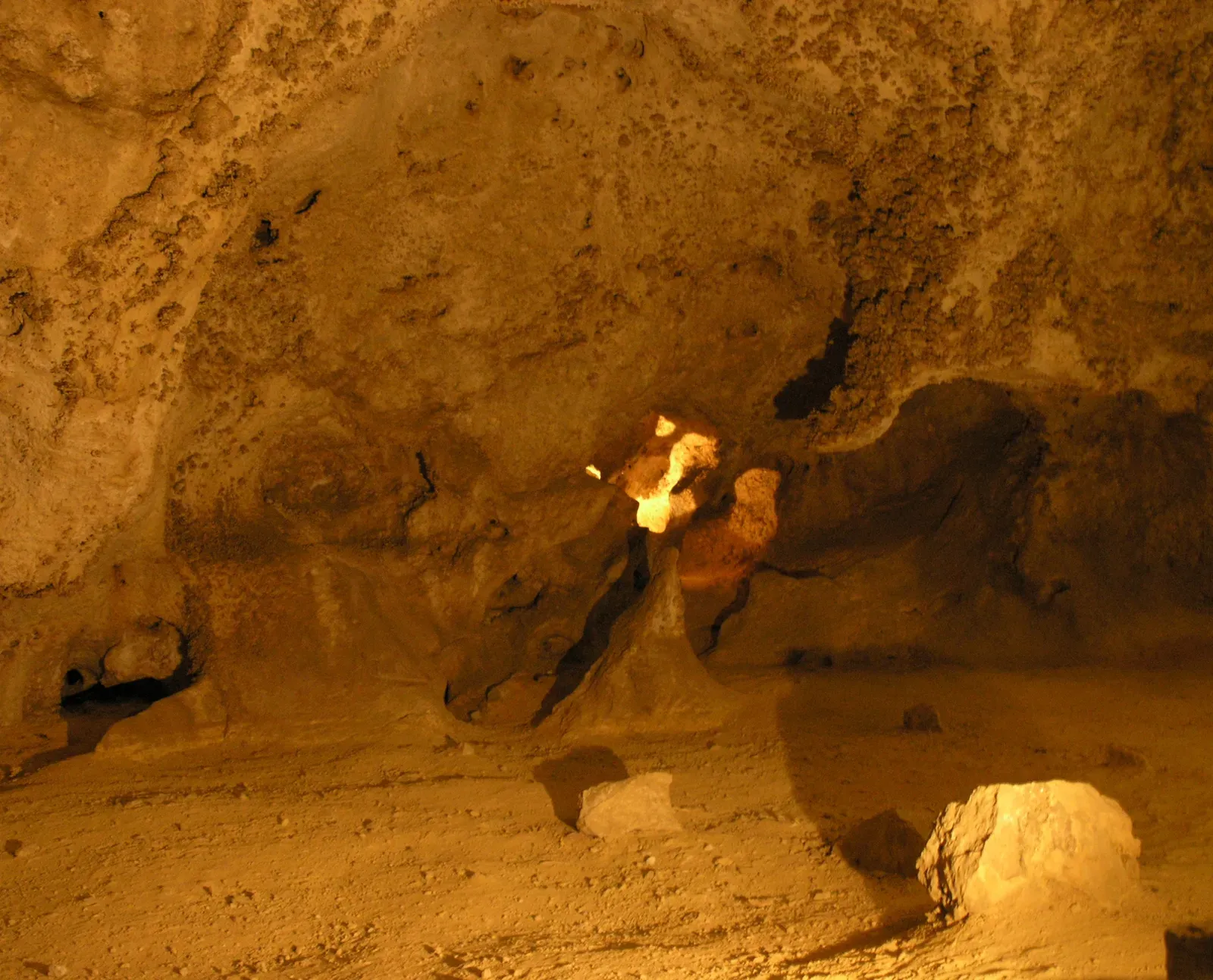
Most caves are carved by water. Carlsbad Caverns was carved by something far more dramatic. Rising sulphur-rich fluids mixed with fresh ground water to form sulphuric acid, which is responsible for the formation of this cave system. That’s a level of geological violence you rarely see spelled out so clearly, and honestly, it makes the caverns feel even more extraordinary.
The park contains more than 100 known caves, including the nation’s deepest limestone cave at 1,604 feet and the third longest. Carlsbad Cavern, with one of the world’s largest underground chambers, displays an amazing array of cave and karst features. The Caverns of Sonora in nearby Sonora, Texas, discovered by accident in the early 1900s, have also become renowned for their otherworldly array of mineral deposit formations, including imposing stalactites, intricate stalagmites, and delicate, shimmering calcite crystals. The underground world of the American Southwest is frankly on another level.
9. Bisti Badlands, New Mexico: The Alien Wilderness Without a Map
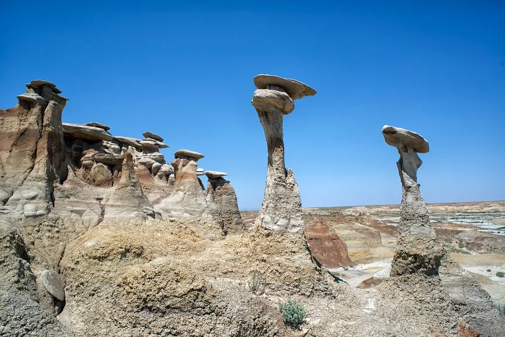
The Bisti Badlands, formally known as the Bisti/De-Na-Zin Wilderness, is where Earth drops its pretense of being a welcoming planet. Located in the arid desert of northwestern New Mexico, the Bisti Badlands offers one of the closest approximations of an unknown alien world as can be found right here on Earth. The area takes its name not only from the striking stone formations that litter the landscape, with “bisti” being a Navajo term meaning “among the adobe formations,” but also from petroglyphs of a crane found in the area.
The blasted landscape is covered in strange, undulating fungal shapes made of colorful sandstone and shale. Huge hoodoos and small labyrinths of odd stone shapes have been created by eons of water and moisture wearing away at a softer layer of ash, creating improbable, top-heavy oddities. This 45,000-acre wilderness protects unique geological features and paleontological resources, including petrified wood and vertebrate fossils. There are no trails, no signs, and no cell service. It’s hard to say for sure, but this might be the most genuinely otherworldly place in all of North America.
10. Crater Lake, Oregon: The Deepest Blue You’ve Ever Seen
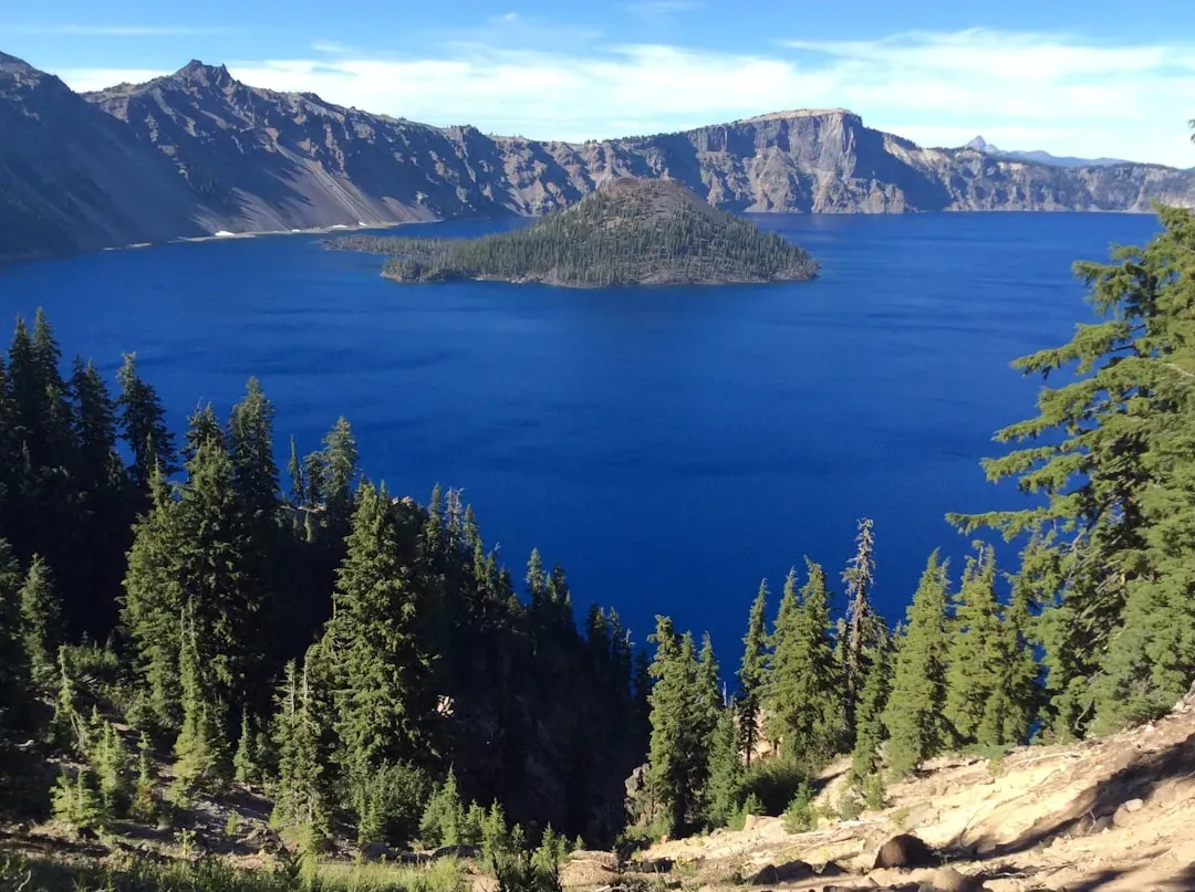
Some geological formations are spectacular because they’re strange. Crater Lake is spectacular because it’s impossibly beautiful, and the story behind it is almost tragic. Crater Lake in Oregon is the deepest lake in the United States, formed around 7,700 years ago when Mount Mazama erupted and collapsed. Its pristine blue waters are fed solely by rain and snow, making it one of the clearest lakes in the world.
Native American legends tell of the lake’s origin as a battle between the sky god and the mountain god, resulting in the mountain’s destruction. Visitors are drawn to its serenity and hiking trails, where they can see Wizard Island, a volcanic cone that rises from the lake’s surface. Think about it: a mountain essentially swallowed itself and left behind a lake so clear and blue it looks photoshopped. It’s the kind of place that makes you feel genuinely small.
11. Painted Hills, Oregon: A Geological Timeline Painted in Technicolor
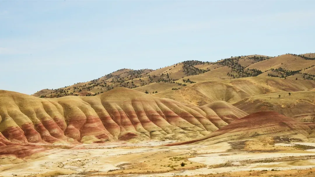
Few places in North America capture geological time as vividly and visually as Oregon’s Painted Hills. The Painted Hills are more than a mind-bending natural masterpiece. Millions of years of history make up the unexpected multi-colored layers of this ancient landscape in central Oregon. Located in the John Day Fossil Beds National Monument, the rainbow-hued hills started as volcanic fallout and continued to form over millions of years of climatic changes and geological processes.
The spectrum of colors splashed across the rock formations, which range from deep red and purple to golden yellow and inky black, are the result of the soil’s unique minerals and rock formations. Walking among the hills feels like reading a textbook written in pigment instead of words. Each color band represents a different era, a different climate, a completely different Earth. It is, without a doubt, one of the most underrated landscapes on the continent.
12. Yellowstone’s Caldera, Wyoming: A Supervolcano Sleeping Beneath Your Feet

Let’s end with something that puts all the other entries in perspective. The Yellowstone Caldera is the largest in North America. The Yellowstone hotspot has actually produced three calderas in the Yellowstone region, the youngest of which is nearly 80 kilometers long and 50 kilometers wide. You’re not just visiting a park when you visit Yellowstone. You’re standing on the roof of a sleeping giant.
Yellowstone contains over half of the 1,000 or so known geysers in the world, including Steamboat, the world’s tallest geyser. Yellowstone National Park sits inside an ancient volcanic caldera with magma, in some places only a few miles underground, powering the park’s famous geysers, hot springs, fumaroles, and mud pots. Up until 2 million years ago, there were caldera-forming eruptions roughly once every 600,000 years, and future eruptions are expected. That detail alone should give you a good reason to stop and stand quietly for a moment when you visit.
Conclusion: The Earth Is Still Writing Its Story
North America’s geological wonders are not just scenic backdrops. They are living records of volcanic fury, patient erosion, ancient seas, and tectonic upheaval stretching back billions of years. The richly textured landscape of the United States is a product of the dueling forces of plate tectonics, weathering and erosion. Over the 4.5 billion-year history of the Earth, tectonic upheavals and colliding plates have raised great mountain ranges while the forces of erosion and weathering worked to tear them down.
What’s most humbling is that the planet is still at it. Thor’s Well keeps carving. The Painted Hills keep fading and refreshing with every rainfall. The Yellowstone Caldera keeps breathing. These twelve formations remind you that the ground beneath your feet is far from stable or permanent. It’s a work in progress, and you’re lucky enough to be alive to witness it.
The question isn’t really whether these places are worth visiting. The question is: which one do you tackle first? Drop your thoughts in the comments below – we’d love to know which of these wonders is at the top of your list.