There are places in this country where the earth itself seems to remember. Where rock faces hold ancient paintings, canyon walls whisper in languages older than written words, and the ground beneath your feet was sacred long before a single border was drawn on a map. These are not just landscapes. They are living, breathing libraries of human endurance and geological spectacle, stacked one on top of the other.
Honestly, most people have no idea how deeply entwined Native American history and raw geological drama are across the American West. The same forces that carved a canyon into a cliff also gave ancient peoples their shelter, their spiritual compass, their home. You’ll want to read every one of these destinations carefully, because each one carries a story that will genuinely stop you in your tracks. Let’s dive in.
Monument Valley, Arizona and Utah: The Navajo Nation’s Cathedral of Rock

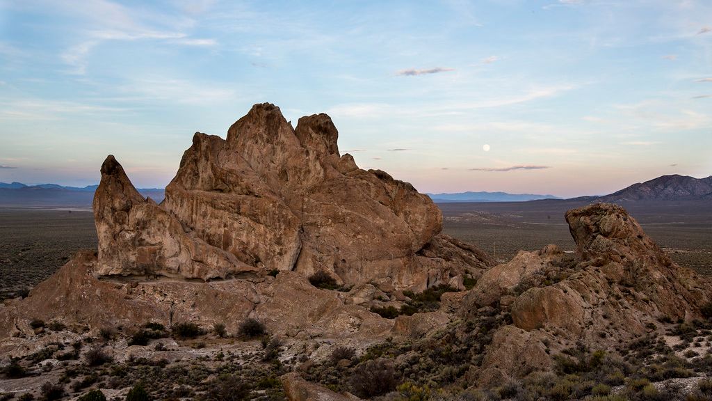
You’ve seen Monument Valley a thousand times without realizing it. It’s been the backdrop of John Wayne westerns, Forrest Gump’s famous run, and countless road trip photographs. Monument Valley, known in Navajo as Tsé Biiʼ Ndzisgaii, meaning “valley of the rocks,” is a region of the Colorado Plateau characterized by a cluster of sandstone buttes, with the largest reaching 1,000 feet above the valley floor. But here’s the thing. The cinematic fame barely scratches the surface of what this place actually is.
The geological genesis of Monument Valley begins deep in the Permian Period, approximately 250 to 300 million years ago, when the region was not the arid, elevated plateau it is now, but rather a dynamic environment of shallow marine seas, coastal plains, and vast desert dune fields. The reddish hues in the sand and rock are due to iron oxide, and the black streaks of desert varnish are manganese oxide. Eroded by wind and rain, soft red shale undermines the stronger, vertically jointed sandstone, producing the many buttes and pinnacles you see today.
For the Navajo people, who have called this land home for centuries, the geological features of Monument Valley are not merely inanimate rock formations. They are sacred entities, imbued with spiritual significance, representing ancestors, spirits, or places of power. Ice Age Paleo-Indian hunters occupied the Monument Valley area between 12,000 and 6,000 BC. Archaic hunter-gatherers left evidence between 6,000 BC and the Christian Era. Anasazi farmers arrived about the beginning of the Christian Era and suddenly disappeared around 1300.
Contrary to what some might assume, Monument Valley is not a National Park, but rather a Tribal Park, as it lies within the boundaries of the Navajo Nation. Many rock formations are tied to Navajo beliefs, oral traditions, and cultural identity. Because of this living connection, access to certain areas is limited to Navajo-guided tours. These experiences are not only about sightseeing but about understanding the land through the perspective of those who have lived with it for generations.
Chaco Canyon, New Mexico: A Lost Civilization Written in Stone and Stars
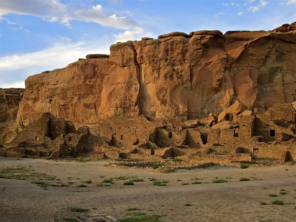
If you think ancient civilizations only flourished on the other side of the Atlantic, Chaco Canyon will permanently correct that assumption. Chaco Culture National Historical Park is located in northwestern New Mexico, between Albuquerque and Farmington, in a remote canyon cut by the Chaco Wash, containing the most sweeping collection of ancient ruins north of Mexico and preserving one of the most important cultural and historical areas in the United States. Let’s be real, this place deserves far more attention than it typically gets.
Between AD 900 and 1150, Chaco Canyon was a major cultural center for the Ancestral Puebloans. Chacoans quarried sandstone blocks and hauled timber from great distances, assembling fifteen major complexes that remained the largest buildings ever built in North America until the 19th century. These structures were often aligned with solar, lunar, and cardinal directions and placed within a landscape surrounded by sacred mountains, mesas, and shrines. It’s hard to say for sure what drew people here in such extraordinary numbers, but the sophistication of what they built tells you this was no temporary settlement.
Among the canyon’s most fascinating features are the spiral petroglyphs carved into the face of the rock near the top of Fajada Butte. Along with these spiral glyphs are three vertically aligned slabs of stone that cast a line of light at precise locations across the spiral glyphs, depending upon whether it is the winter or summer solstice, or an equinox. It has even been suggested that the 19-year cycle of the moon was also factored into the position of the slabs.
The Chaco Wash flowed across the upper strata of what is now the 400-foot Chacra Mesa, cutting into it and gouging out a broad canyon over the course of millions of years. The mesa comprises sandstone and shale formations dating from the Late Cretaceous, which are of the Mesaverde Group. The sites are considered sacred ancestral homelands by the Hopi and Pueblo people, who maintain oral accounts of their historical migration from Chaco and their spiritual relationship to the land. You’ll find very few places on Earth where astronomy, architecture, geology, and spiritual legacy collide so dramatically in one canyon.
Mesa Verde National Park, Colorado: Cities in the Cliff Face

There’s something almost impossible to believe about Mesa Verde until you actually stand in front of it. Mesa Verde, Spanish for “green table,” rises high above the surrounding country of southwest Colorado, providing a spectacular look into the lives of the Ancient Puebloan people who made it their home for over 700 years, from 600 A.D. to 1300 A.D. You could spend a full week here and still feel like you’ve missed something important.
Stream erosion during the past two million years cut deep canyons into the plateau, leaving narrow strips of high tableland between the canyons. Water erosion formed niches and alcoves of various sizes in the sandstone of these canyon walls, which is precisely where the cliff dwellings are located. The shale zones in the Cliff House Sandstone determine where alcoves formed, and it was exactly within these alcoves that the Ancestral Puebloans constructed their dwellings. Think of it like geology doing the architectural groundwork for an entire civilization.
The largest cliff dwelling in the park is Cliff Palace, which housed as many as 250 people in its 217 rooms and 23 kivas. Long House, the second largest cliff dwelling, has 150 rooms and 21 kivas, where some 150 people lived. However, of the approximately 600 cliff dwellings in the park, most have only one to five rooms each.
Today, there are 26 tribes that have a special relationship with Mesa Verde National Park. Affiliated tribes include the 19 Pueblos of New Mexico: Acoma, Cochiti, Isleta, Jemez, Laguna, Nambe, Ohkay Owingeh, Picuris, Pojoaque, Sandia, San Felipe, San Ildefonso, Santa Ana, Santa Clara, Santo Domingo, Taos, Tesuque, Zia, and Zuni. Packed with over 5,000 archaeological sites, Mesa Verde contains some of the best-preserved examples of ancient history in the United States, and its exceptional archaeological relevance earned it UNESCO World Heritage status in 1978.
Canyon de Chelly, Arizona: 5,000 Years Written Into the Walls
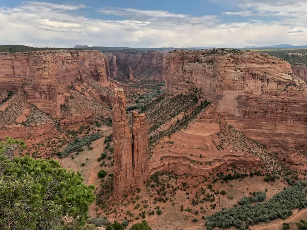
Say the name correctly first. It’s pronounced “d’SHAY,” derived from the Navajo word Tséyi, meaning “deep in the rock.” Canyon de Chelly is a protected site that contains the remains of 5,000 years of Native American inhabitation, located in the northeastern portion of Arizona within the Navajo Nation. That number, five thousand years, is worth sitting with for a moment. Five thousand years of continuous human presence in one canyon system.
The history of Canyon de Chelly began 230 million years ago, when vast inland seas covered much of the North American continent. By the end of the Permian period, the seas had begun to dry up, leaving layers of mud and sand in their wake. At the same time, mountains were forming as land was pushed from beneath the surface. The new mountains blocked the prevailing winds, cutting off moisture from the eastern slopes and generating deserts and vast sand dunes. Among the more striking features of the cliff faces is the “desert varnish,” striking dark vertical streaks that look as though they were painted on the canyon walls, caused by chemical deposits from oxidation of the minerals in the rock.
Canyon de Chelly is entirely owned by the Navajo Tribal Trust of the Navajo Nation. It is the only National Park Service unit that is owned and cooperatively managed in this manner. About 40 Navajo families still live in the park today. The park’s most distinctive geologic feature, Spider Rock, is a sandstone spire that rises 750 feet from the canyon floor at the junction of Canyon de Chelly and Monument Canyon.
Built into a sheer 500-foot sandstone cliff, the White House was constructed and occupied between 1060 A.D. and 1275 A.D. The White House takes its name from the white plaster used to coat the long back wall in the upper dwelling. Access to the canyon floor is restricted, and you are allowed to travel in the canyons only when accompanied by a park ranger or an authorized Navajo guide, with the only exception being the White House Ruin Trail. That policy isn’t just bureaucratic, it reflects a profound respect for land that has never stopped being a homeland.
Bears Ears National Monument, Utah: Sacred Ground at the Heart of the Colorado Plateau
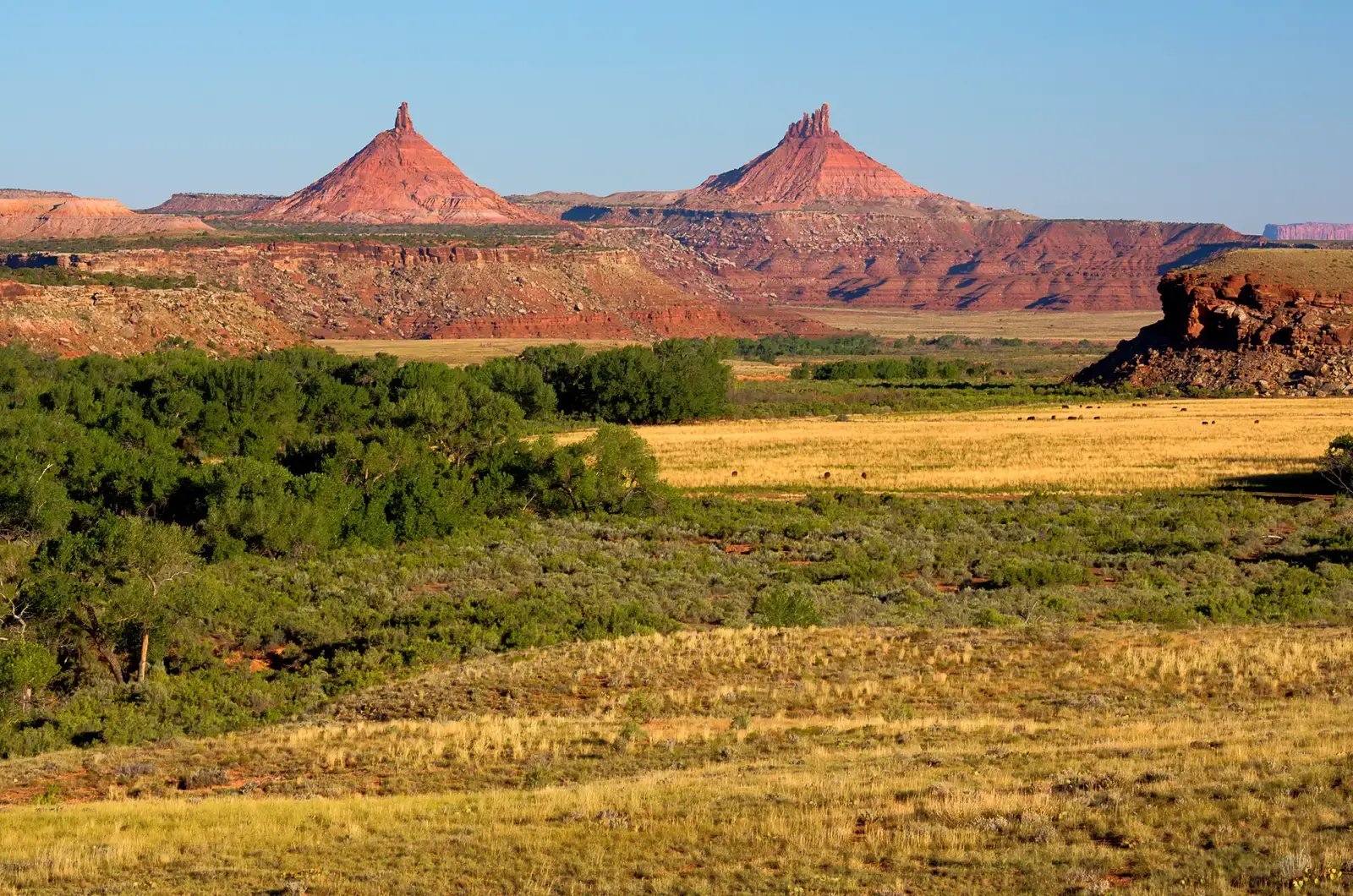
Bears Ears is the newest name for one of the oldest stories on the continent. This sprawling, landscape-scale monument in southwest Colorado contains thousands of known archaeological sites that have yielded invaluable historical information on Ancestral Puebloan cultures and other indigenous groups. To visit Bears Ears is to stand in territory that five tribal nations, the Navajo Nation, Hopi Tribe, Ute Mountain Ute Tribe, Ute Indian Tribe of the Uintah and Ouray Reservation, and Pueblo of Zuni, fought hard to see protected.
Diné-owned tour company Ancient Wayves River and Hiking Adventures can arrange day-long and multi-day hikes that include jaw-dropping views of the area’s natural wonders in Utah, such as the Valley of the Gods in Bears Ears National Monument. Native American-led tours provide you with an immersive way to explore Indigenous cultures and sites, including an Anasazi petroglyph located below the summit of Comb Ridge in Southern Utah. I think this is honestly the most important way to experience Bears Ears: through the perspective of people whose cultural memory is embedded in every rock panel and canyon shelf.
The Trail of the Ancients is a 480-mile scenic byway that winds through the Colorado Plateau in Colorado and Utah and invites exploration of Native American history and geographic wonders. Managed by the Bureau of Land Management, the sandstone valley within Bears Ears National Monument features formations with names as vivid as their geology, including Battleship Rock and other creatively named geological structures. The landscape here is equal parts museum and cathedral.
Located in Southeast Utah on the Navajo Nation Reservation near Bears Ears National Monument, guided tour operators offer day-long and multi-day hikes as well as river tours led by citizens of the Native American tribes for whom this land is sacred. On guided tours through this region, you will see petroglyphs that indicate an intense interest in solar and lunar cycles, and the orientation of many buildings aligns precisely with the summer and winter solstices. The ancient people here were not just surviving. They were observing, calculating, and leaving a record of their cosmic awareness chiseled into stone.
Conclusion: These Places Demand More Than a Photograph

What makes all five of these destinations extraordinary isn’t just the towering geology or the remarkable ruins. It’s the fact that neither exists in isolation from the other. The sandstone alcoves at Mesa Verde weren’t coincidental, they were a geological invitation that Ancestral Puebloans accepted with breathtaking creativity. The canyon walls at Canyon de Chelly weren’t just shelter, they were canvases for a civilization’s memory.
Each of these places asks something of you as a visitor. Respect the land. Honor the guides who share their knowledge. Understand that what you’re walking through is not an ancient ruin abandoned by history, but a living, continuous story that many Indigenous communities are still writing today. These destinations don’t just show you where people once lived. They show you how deeply a people and a landscape can become one and the same thing.
The real question is this: when you finally stand at the rim of one of these canyons or beneath a 300-million-year-old sandstone butte, will you feel the weight of what came before you? Chances are, you absolutely will.