Imagine standing on the edge of a canyon so vast you can barely process its scale, looking down through layers of rock that tell a story spanning nearly two billion years. You are not just sightseeing. You are reading the Earth’s autobiography, written in sandstone, limestone, and ancient volcanic glass. The American Southwest is unlike anywhere else on the planet in this regard.
Nearly two billion years of the Earth’s history are represented in the landscape of the American Southwest. From craters blasted by space rocks to canyons shaped one grain of sand at a time, each formation here whispers something profound about the forces that built our world. So let’s dive in, because what you are about to discover might just rearrange how you think about the ground beneath your feet.
The Grand Canyon: Earth’s Greatest Open Book
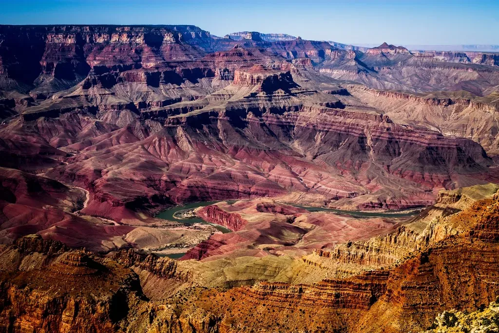
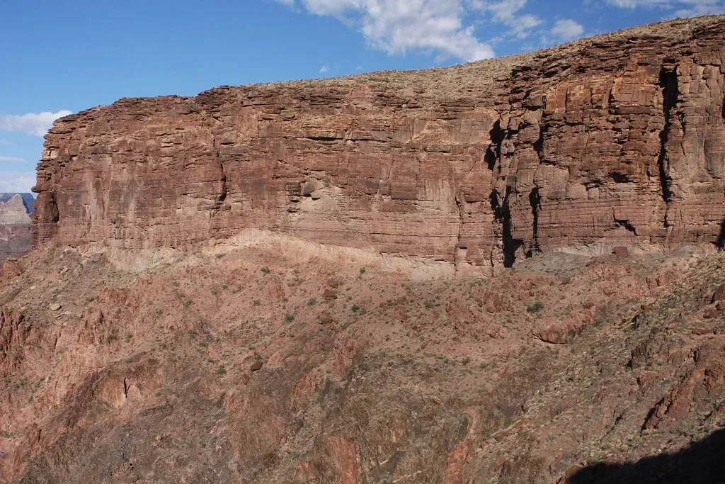
You have probably seen the photos. You may have even stood at the rim yourself. But here is the thing most people miss when they gaze into the Grand Canyon: they are not just looking at a hole in the ground. It exposes an exceptionally complete rock record of 1.84 billion years, representing roughly 40 percent of Earth’s entire history. That is not a canyon. That is a time machine you can walk into.
The oldest rock in the Grand Canyon, known as the Elves Chasm Gneiss, is located deep in the canyon’s depths as part of the Vishnu Basement Rocks and comes in at an ancient 1.84 billion years old. This incredible formation was carved over millions of years by the Colorado River, and the canyon itself has formed much more recently than the deposition of rock layers, only about five million years ago, as opposed to the rocks, the youngest of which are a little less than 300 million years old. When you think about it that way, the canyon itself is practically a newborn.
The Grand Staircase: A Stairway Through Time You Can Actually Climb
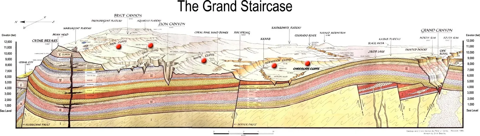
You may not have heard of the Grand Staircase as often as the Grand Canyon, but geologists absolutely adore it. The Grand Staircase is a sequence of sedimentary rock layers, first defined in the 1870s, that stretch south for 100 miles from Bryce Canyon National Park through Zion National Park and into the Grand Canyon. Think of it as a massive geological filing cabinet, with each drawer holding a different chapter of Earth’s ancient history.
The formations exposed in the area of the parks are part of this Grand Staircase. The oldest members of this super sequence of rock units are exposed in the Grand Canyon, the intermediate ones in Zion National Park, and its youngest parts are laid bare in Bryce Canyon. Just as the Grand Canyon is the best-known record of ancient geologic history from the Paleozoic, and Zion Canyon records most clearly the events of medieval time in the Mesozoic, the cliffs and canyon walls of Bryce Canyon reveal much of modern geologic history from the Cenozoic. That means you are essentially walking upstairs through hundreds of millions of years just by traveling between parks.
Zion National Park: Where Ancient Sand Dunes Became Towering Cliffs
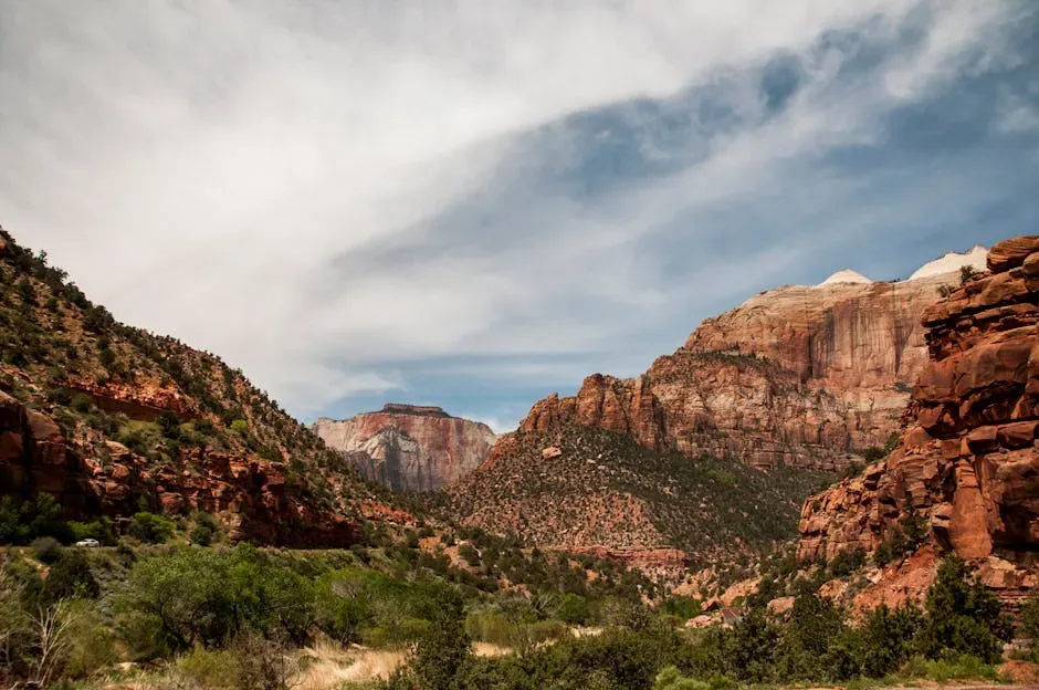
Here is something that sounds impossible until you understand geology. Those massive, breathtaking walls of pale sandstone you see in Zion were once sand dunes. Enormous, wind-piled desert dunes, similar to the Sahara but on a scale that would make modern dunes look like sandcastles. Zion National Park preserves a geologic record of shifting environments from shallow seas to vast desert sand dunes over hundreds of millions of years. Some of the largest ancient sand dunes in the geologic record were gradually buried, compacted, and cemented into the Navajo Sandstone that forms Zion’s towering 2,000-foot cliffs.
What carved those cliffs into the dramatic slot canyons and gorges you wander through today? Water. Specifically, a patient and relentless river. Tectonic uplift raised the Colorado Plateau, and as seas retreated, rivers began carving into the rock. Over time, the Virgin River and its tributaries cut through the sandstone, forming the deep canyons seen in Zion today. The geologic heart of the canyon began as a vast desert millions of years ago, as almost incessant winds blew one dune on top of another until the sands reached a depth of more than 2,000 feet. You can still see the track of these ancient winds in the graceful crossbedded strata of Zion’s mighty cliffs. Honestly, standing there and knowing all that makes the view feel almost supernatural.
Bryce Canyon: Hoodoos, Frozen Time, and an Ancient Inland Sea
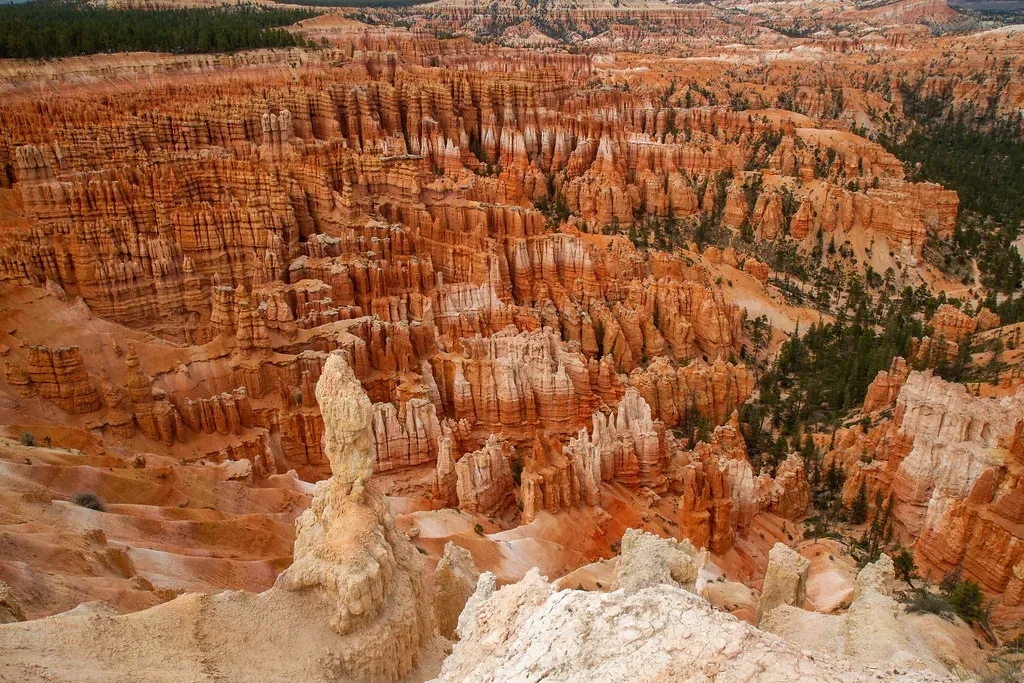
Bryce Canyon is one of those places that genuinely stops you cold. The hoodoos, those narrow, spire-shaped rock columns rising from the canyon floor in shades of red, orange, and white, look almost alien. Located in the High Plateaus region of the Colorado Plateau in Utah, Bryce Canyon’s elevation, erosion, climate, and rock type are all elements that create fantastically surreal rock spires called hoodoos that can rise hundreds of feet into the sky. No wonder it draws visitors from every corner of the world.
The exposed geology of the Bryce Canyon area in Utah shows a record of deposition that covers the last part of the Cretaceous Period and the first half of the Cenozoic era in that part of North America. The ancient depositional environment varied from the warm shallow sea called the Cretaceous Seaway, in which the Dakota Sandstone and the Tropic Shale were deposited, to the cool streams and lakes that contributed sediment to the colorful Claron Formation that dominates the park’s amphitheaters. Other formations were also created but were mostly eroded following uplift from the Laramide orogeny, which started around 70 million years ago, an event that raised the Rocky Mountains far to the east and caused the retreat of the sea that covered the Bryce Canyon area. The sea that once covered your favorite hiking destination is now long gone, leaving only its stunning memory in stone.
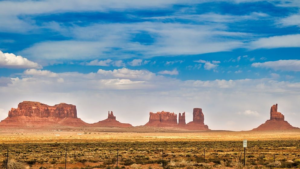
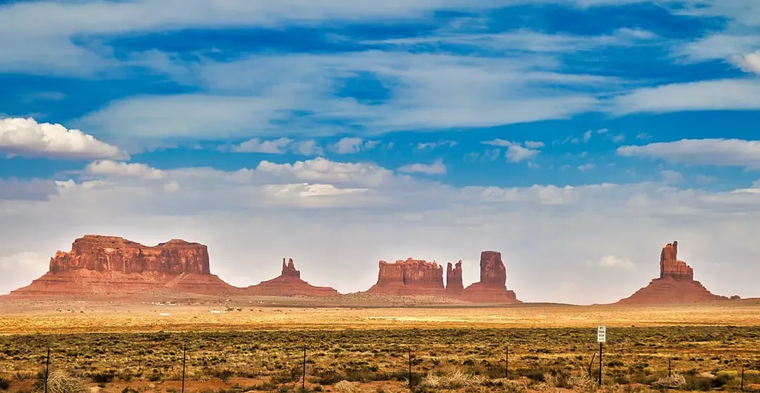
Monument Valley: Sentinels of a Vanished Landscape
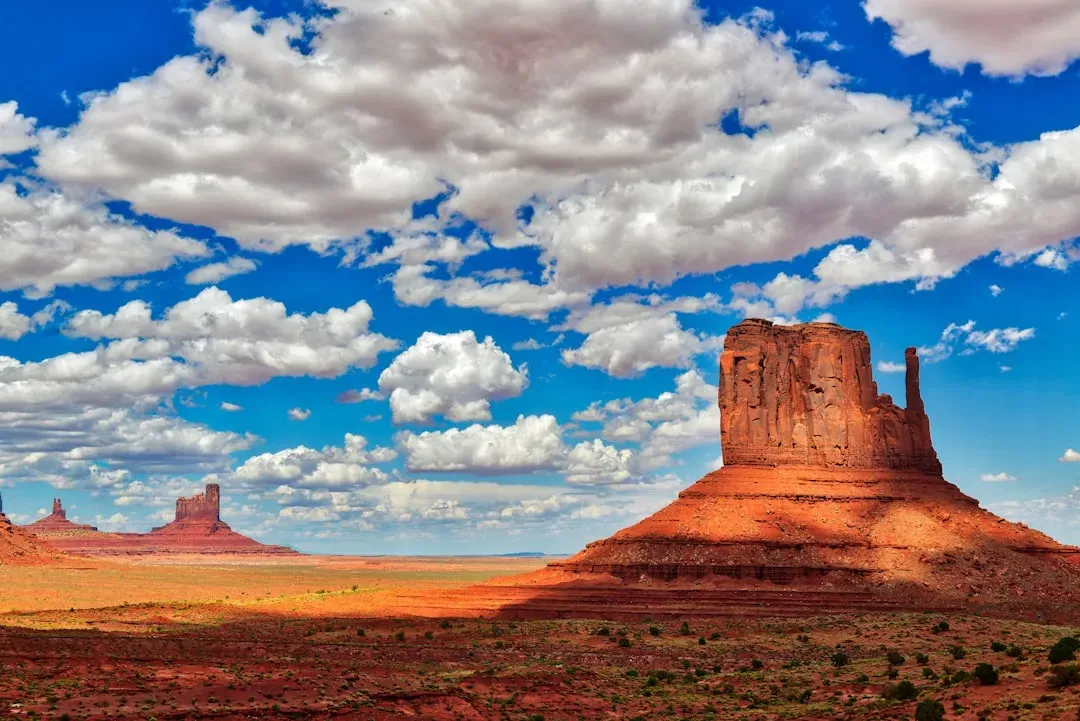
Few landscapes in the world are as immediately recognizable as Monument Valley. Those towering sandstone buttes rising from a flat, rust-colored desert floor have appeared in countless films, photographs, and paintings. Monument Valley draws nearly half a million visitors every year to its famous rock formations along the Utah and Arizona border. Yet the real story of how these iconic sentinels came to stand here is even more dramatic than any film set.
The climate at low latitudes on the ancient supercontinent Pangaea was hot and dry, and iron-rich limestones, sandstones, and mudstones were oxidized. This process generated rocks with a distinctive and characteristic red color, appropriately called “red beds,” which are very characteristic of the Southwest, particularly in the Colorado Plateau region. The buttes of Monument Valley are essentially the last standing remnants of what was once a much thicker, continuous rock layer. Everything around them eroded away over millions of years, leaving these massive columns behind, like pillars in a roofless cathedral. Many of these red beds represent ancient dunes, which means you are looking at the preserved footprints of an impossibly ancient desert wind.
The Great Unconformity: Where One Billion Years Simply Vanished
I think this might be the most mind-bending geological feature in the entire Southwest, and yet most visitors walk right past it without even realizing what they are seeing. The contact known as an “unconformity” marks a place where so much erosion occurred before a new layer of rock formed that we are actually missing time from our geologic record. A gap in Earth’s diary, essentially. Except this gap is not a few pages. It is not even a chapter.
This particular gap created a major unconformity that represents 460 million years of lost geologic history in the area. This is known as the “Great Unconformity,” because so much time is unaccounted for that mountains could have been built and then completely eroded away within the period that is missing. Ancient Precambrian rocks, exposed only in the deepest canyons, make up the basement of the Colorado Plateau. Most are metamorphic rocks formed deep within the Earth while continental collision on a grand scale produced the nucleus of the North American continent well over a billion years ago. You can literally place your hand on the line where nearly half a billion years of history simply do not exist anymore. It is hard to say for sure what happened during that gap, but geologists believe erosion stripped it all clean.
Meteor Crater, Arizona: The Scar of a Cosmic Collision
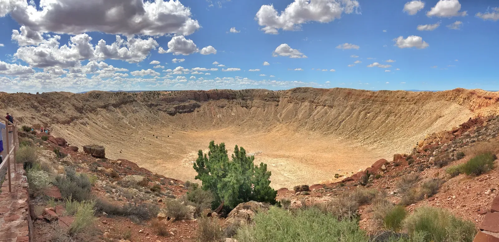
The Southwest’s geological drama is not just a story of slow, grinding forces playing out over millions of years. Sometimes Earth’s transformations happen in a single, violent instant. About 49,000 years ago, a large iron asteroid between 30 and 50 meters in diameter impacted the Colorado Plateau in northern Arizona. The resulting massive explosion excavated 175 million tons of rock, forming a crater nearly a mile wide and 570 feet deep. Try to picture that. An explosion big enough to hollow out a bowl you could fit a major city into.
The Canyon Diablo meteorite exploded with the force of over 2 million tons of TNT, about 150 times the force of the atomic bomb detonated over Hiroshima. Very few remaining craters are visible on Earth, since many have been erased by erosive geological processes. The relatively young age of Meteor Crater, paired with the dry Arizona climate, has allowed this crater to remain comparatively unchanged since its formation. When the asteroid hit, humans had not yet reached North America. The terrain of forested rolling hills was likely inhabited by mammoths, mastodons, and giant ground sloths. The thought that something so dramatic happened so recently in geological terms, and left such a perfect scar, is honestly a little humbling.
The Colorado Plateau: A Billion-Year Foundation Rising from Below
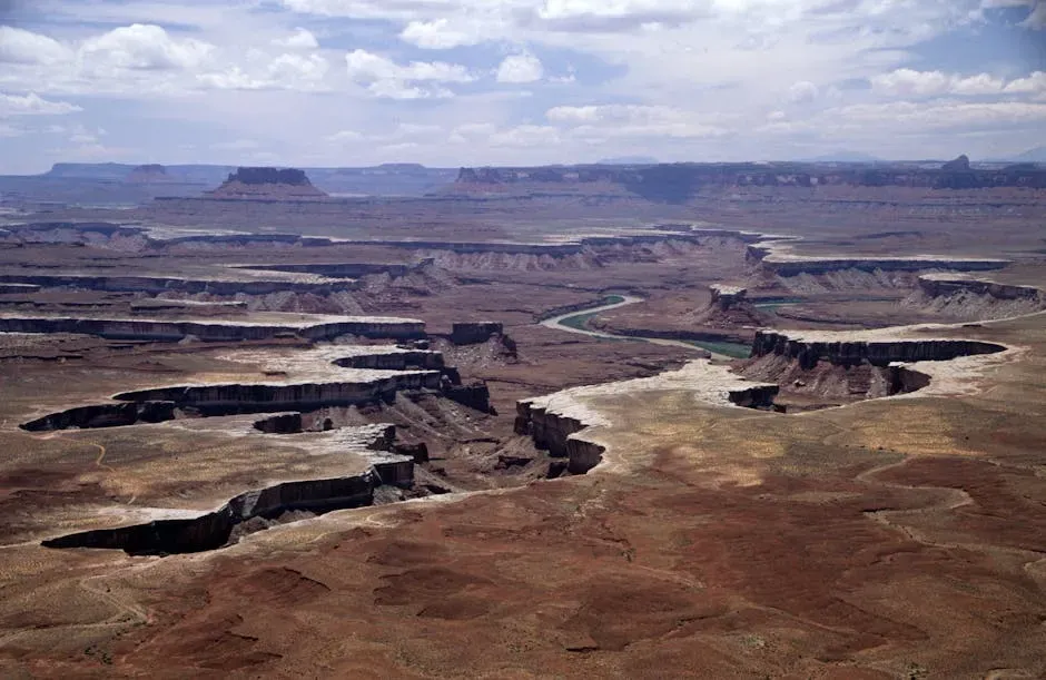
Beneath every single one of the marvels described in this article, there is a foundation so ancient and so stable that geologists treat it almost with reverence. The Colorado Plateau is roughly centered on the Four Corners region of the southwestern United States, covering an area of 337,000 square kilometers within western Colorado, northwestern New Mexico, southern and eastern Utah, and northern Arizona. It is the grand stage upon which all of the Southwest’s geological drama has played out.
The subsurface basement rock that underlies much of the Colorado Plateau is made up of cratonic elements, called provinces, that are about 1.8 to 1.6 billion years old. This basement rock is divided into three provinces: the Mojave Province in western Arizona and Utah; the Yavapai Province in Colorado, central Arizona, northwestern New Mexico, and southeastern Utah; and the Mazatzal Province in southeastern Arizona and New Mexico. These provinces accreted to the edge of Laurentia, the ancient North American continent, in orogenic mountain-building events. The geologic history of the southwestern United States spans more than two billion years. This history is unusually well exposed throughout the area’s extraordinary geological landscape, including spectacular mountains, canyons, and countless other striking features. In a very real sense, you are walking on some of the most ancient and storied ground in all of North America.
A Final Thought Worth Carrying With You
The eight geological wonders covered in this article are more than just spectacular scenery. Each one is a chapter in a saga that began long before any life existed on land, when the forces shaping continents were still assembling the very ground you now walk on. This entire Southwest region is a geologist’s dream, as its rocks provide examples and timelines of many of the processes still shaping the Earth today.
What strikes me most is how these formations are not frozen relics. They are actively changing, eroding, and shifting, just too slowly for us to notice in a single lifetime. The Colorado River is still cutting deeper into the Grand Canyon. Hoodoos in Bryce are still wearing away with every freeze and thaw. The Southwest’s dynamic geologic history has resulted in the formation, preservation, and exposure of rocks from a wide variety of ages and sources. Rocks exposed in the Southwest reveal that a large continental mass, a supercontinent, was repeatedly assembled and disassembled over hundreds of millions of years. You are not visiting a museum. You are watching the Earth still at work.
Next time you stand at the rim of one of these marvels, take a moment to feel the full weight of that. The rock beneath your feet is older than anything you have ever touched. Does knowing all this change how you see the Southwest? Tell us in the comments.