When you think about finding your way in the middle of the ocean without any gadgets or maps, it seems nearly impossible. Yet ancient humans managed to cross thousands of miles of open water, guided only by what they could see above and around them. The night sky was their GPS, their compass, and their clock all wrapped into one glittering canvas.
Long before satellites and smartphones, people figured out that those twinkling lights weren’t just pretty to look at. They held secrets about direction, time, and location. From sailors crossing the Mediterranean to Polynesian voyagers conquering the Pacific, humans learned to read the heavens like a book. Let’s explore how our ancestors turned the stars into their most reliable travel companions.
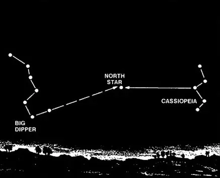
Following the North Star to Find True North

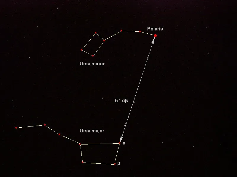
The North Star, or Polaris, was a critical reference point for sailors in the Northern Hemisphere, as it remained fixed in the sky, indicating true north. Unlike other stars that seemed to drift across the night sky, Polaris stayed put, aligned with Earth’s axis of rotation. This made it incredibly valuable for anyone trying to maintain a consistent direction while traveling at night.
The Vikings, fearless seafarers and explorers, relied heavily on the stars to navigate their longships across the treacherous waters of the North Atlantic. By observing the North Star, they could determine their latitude and maintain a steady course, even in the absence of landmarks. Imagine being on a wooden boat in the middle of dark, churning waters with nothing but that single point of light to tell you where north is. It’s hard to say for sure, but their confidence in that star must have been absolute.
Using Star Paths and Constellations as Directional Guides
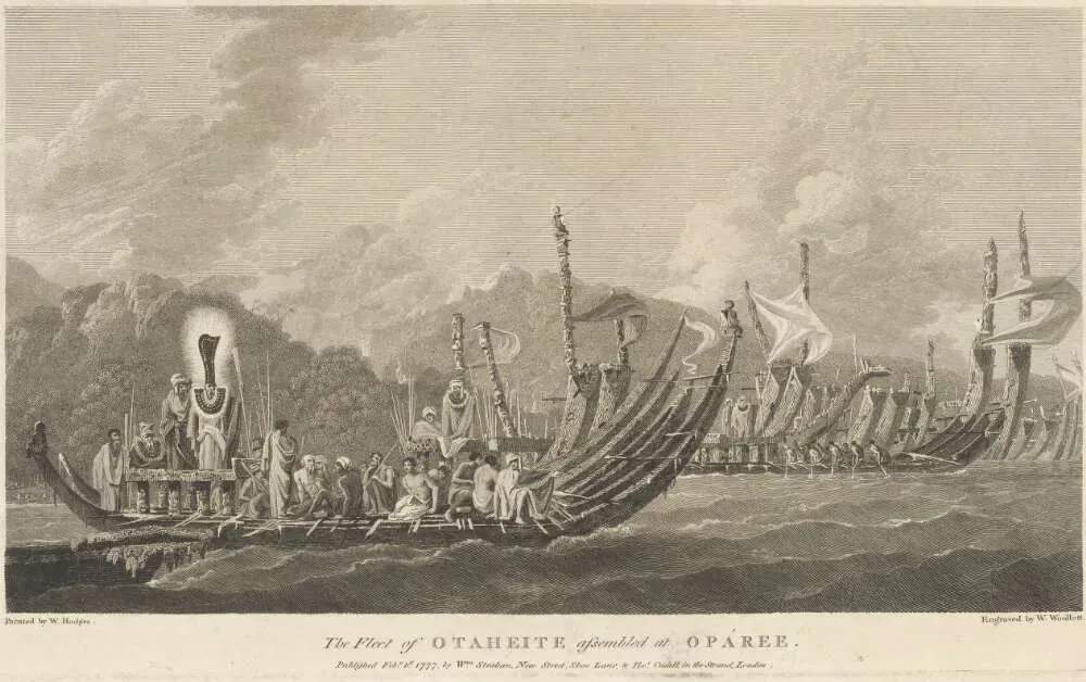
Minoan sailors would use the locations of particular stars, especially those of the constellation Ursa Major, to orient the ship in the correct direction. Different constellations rose and set at predictable points on the horizon, creating what ancient navigators recognized as reliable pathways across the sky. Polynesian voyagers would set a heading by a star near the horizon, switching to a new one once the first rose too high. A specific sequence of stars would be memorized for each route.
Think about the mental stamina required for this. You’d need to memorize dozens, sometimes hundreds, of star positions and their movements throughout the seasons. Master Polynesian navigators memorize the rising and setting positions of hundreds of stars. Let’s be real, most of us struggle to remember our passwords, yet these navigators carried entire star maps in their heads. Each constellation became a signpost, each rising star a cue to adjust course.
Creating Mental Star Compasses for Ocean Voyages
The Hawaiian star compass represents one of the most sophisticated navigation systems ever developed without written records. The compass divides the sky into eight families of stars occupying 32 houses. The houses indicate the position of stars rising and setting at the horizon. Knowing which star houses are rising and setting means that you are able to chart a course from your starting point to a specific destination.
Here’s the thing about this system, it wasn’t just about stars. Wind and ocean swells could also be used for telling direction on the star compass. The wind and swells move diagonally across the compass from quadrant to quadrant. This meant navigators were essentially integrating multiple sensory inputs into one unified directional framework. This type of celestial navigation has been used, along with wind direction and wave observation, to find small islands in the vast world ocean. The Polynesian voyaging canoe Hōkūleʻa has made the 2500 mile voyage from Hawaii to Tahiti many times, using only traditional wayfinding methods. Pretty remarkable when you consider they were crossing distances comparable to traveling from New York to Los Angeles, but over featureless ocean.
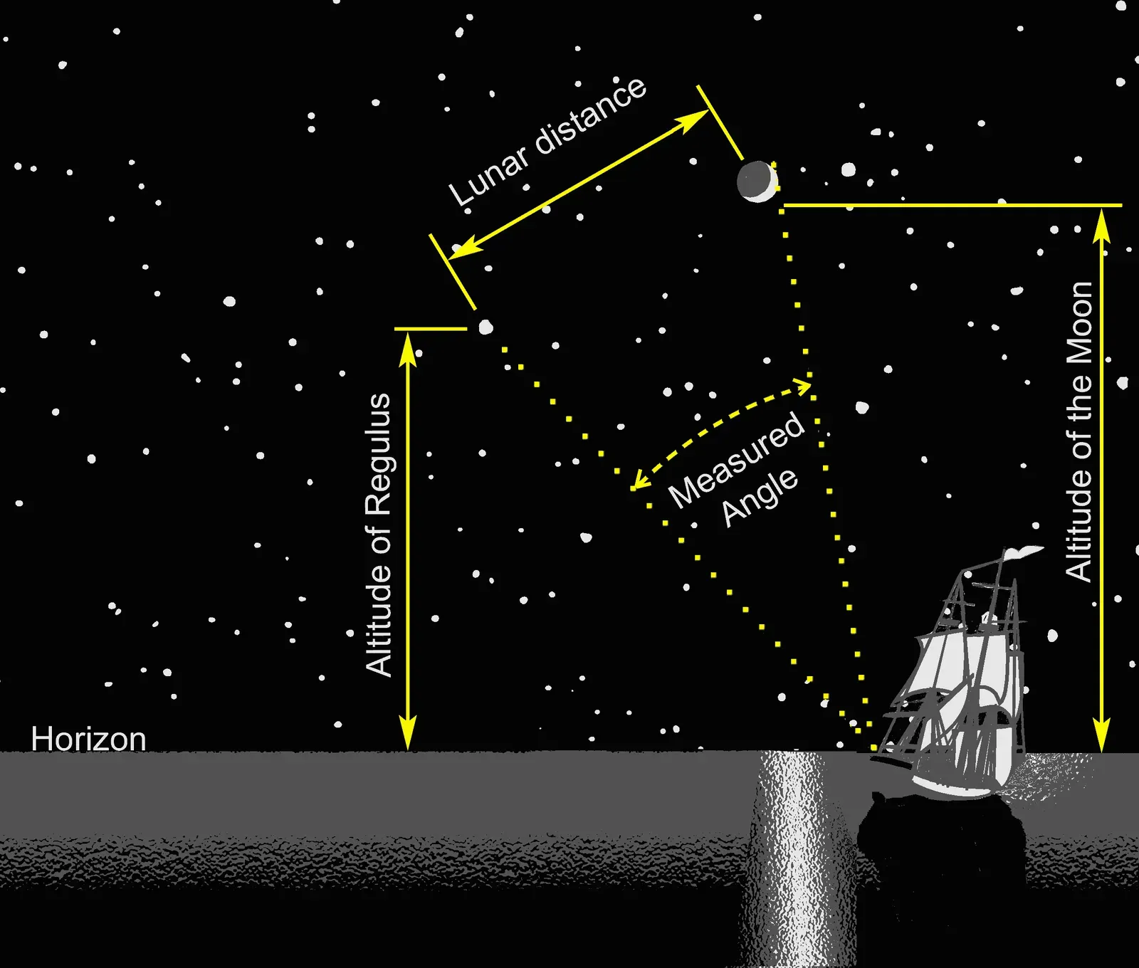
Measuring Latitude Using Star Elevation
The Polynesians took measurements of stellar elevation to determine their latitude. The latitudes of specific islands were also known, and the technique of “sailing down the latitude” was used. By observing how high certain stars appeared above the horizon, navigators could figure out how far north or south they were from the equator. The navigator would take stellar measurements of elevation, often using just their fingers, to determine their latitude.
Your own hand became a measuring tool. Fingers held at arm’s length could gauge angular distances in the sky with surprising accuracy. Once a navigator knew the latitude of their destination island, they could sail until reaching that latitude, then turn and follow it east or west until landfall. The latitudes of specific islands were memorized, employing the technique of “sailing down the latitude” to return to found islands or home. It’s a simple concept, yet it required years of training and a deep understanding of celestial mechanics that most people today couldn’t begin to replicate.
Tracking Seasonal Star Patterns for Timing and Position
Monitoring the motions of stars and planets in the sky was the best tool to track time, which was fundamental for agriculture, religious rituals and navigation. Stars don’t appear in the same place year round. Different constellations become visible during different seasons, giving ancient navigators a celestial calendar. Ancient explorers had to be familiar with the constellations and how their positions changed over the course of the year.
The earliest Polynesian navigators studied the night sky, its celestial bodies and constellations, memorizing positions as they changed through the seasons. The ability to “read” the night sky is a great skill, and this expertise was the foundational tool of traditional Polynesian navigators. Knowing which stars were visible told you not just where you were, but also what time of year it was. This knowledge helped sailors determine the best seasons for travel, when trade winds would be favorable and storms less likely. The night sky became both map and calendar, offering layers of information to those who knew how to interpret it.
Combining Celestial Navigation with Natural Environmental Cues
Stars were never the only tool in the ancient navigator’s kit. Polynesian navigators employed a wide range of techniques including the use of the stars, the movement of ocean currents and wave patterns, the patterns of bioluminescence that indicated the direction in which islands were located, the air and sea interference patterns caused by islands and atolls, the flight of birds, the winds and the weather. The truly skilled wayfinders learned to synthesize all these signals into a coherent picture of where they were and where they were going.
The paths of stars and rhythms of the ocean guided them by night and the color of sky and the sun, the shapes of clouds, and the direction from which the swells were coming, guided them by day. Swells would tell them that there was land ahead, and the surest telltale sign would be the presence of birds making flights out to sea seeking food. On cloudy nights when stars disappeared, navigators could still maintain their course by feeling the direction of ocean swells beneath their canoe. When skies are too overcast for navigators to use the sun, the moon, planets or stars, ocean swells can fill in as a rough guide to direction. An experienced navigator can sense the direction swells are coming from as they pass under the waka. If you note the direction from which the swells are coming at a time when the stars are visible, those same swells can guide you when the stars disappear. Honestly, it’s mind blowing how these navigators turned every possible environmental signal into useful information.
Conclusion

The ability of ancient humans to navigate by the stars represents one of humanity’s most impressive intellectual achievements. Without technology, without instruments, they developed systems of wayfinding so sophisticated that they could pinpoint tiny islands in a vast ocean. These weren’t lucky guesses or accidental discoveries. They were the result of careful observation, rigorous training, and knowledge passed down through countless generations.
Today we rely on satellites and screens to tell us where we are and where we’re going. Yet there’s something humbling about knowing that our ancestors could do the same thing with nothing more than their eyes, their minds, and the stars above. Their legacy reminds us that human ingenuity doesn’t always require advanced technology, just deep attention to the world around us. What do you think about these ancient navigation methods? Could you imagine trying to cross an ocean using only the stars?