The United States is one of the most geologically dramatic countries on the planet. Beneath its surface and across its landscapes, the Earth has been telling a story for billions of years, and most of us are only scratching the surface of what that story actually means. From canyon walls that predate the dinosaurs to underground chambers carved by acid rising from oil fields, the sheer variety of geological storytelling happening across American soil is genuinely mind-blowing.
If you’ve ever stood at the edge of something vast and ancient and felt that strange mix of humility and awe, you’ll understand exactly why these places matter. They aren’t just pretty backdrops. They’re open books written in stone, lava, and time. So let’s dive in.
The Grand Canyon, Arizona: A Two-Billion-Year Timeline Written in Stone
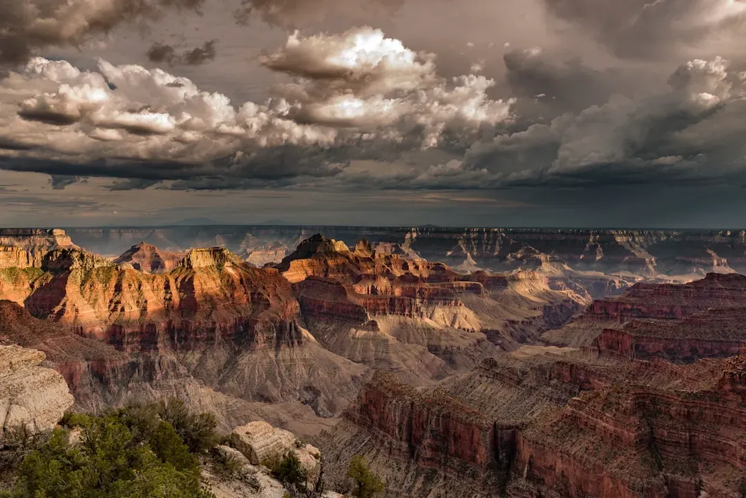
Here’s the thing about the Grand Canyon. You can stand at its rim, stare out across those ribbons of red and gold, and feel like you’re just looking at a nice view. What you’re actually doing is reading nearly two billion years of Earth’s history without even realizing it. Spanning 277 miles in length and over a mile deep, this colossal chasm was carved by the Colorado River over millions of years, exposing layers of rock that date back nearly two billion years. That’s almost half the age of the Earth itself.
The oldest rocks in the Grand Canyon, found at the bottom, are primarily metamorphic. The combination of these metamorphic and igneous rocks is called the Vishnu Basement Rocks, and they are about 1.7 billion years old, from an era early in Earth’s history known as the Proterozoic. Meanwhile, the Kaibab Limestone at the rim is a relatively young 270 million years old, making the canyon walls essentially a slow-motion time machine you can walk through. Honestly, it’s almost absurd that something this informative just sits there in the open air for anyone to see.
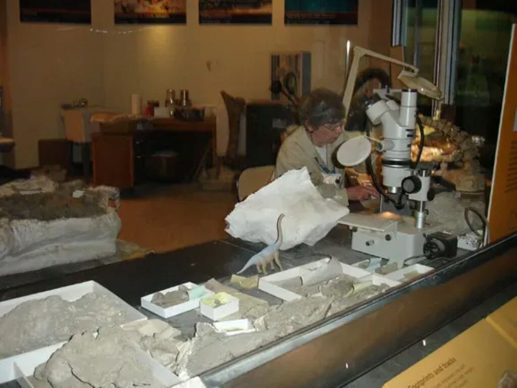
The Paleozoic strata contain many fossils that help scientists learn about the geologic history of North America. Most of the fossils are ocean-dwelling creatures, telling us that the area now in the middle of Arizona was once a sea. If you look closely at the canyon rim, you can literally find evidence of ancient fish, sharks, and sea lilies in the rock. Across one key geological contact at the Grand Canyon, up to 1.3 billion years of Earth history has been removed by erosion in several stages, creating what geologists call the “Great Unconformity.” Think of it like a book with hundreds of millions of missing pages, and the mystery of what those pages contained is still being investigated today.
For nearly 150 years, scientists have been debating how and when the Grand Canyon formed. In recent decades they’ve mostly split into two camps: those proposing a “young canyon” model in which the Colorado River alone carved much of the gorge in the past five million years or so, and those suggesting an “old canyon” model involving a series of ancient rivers. The debate is very much alive. Groundbreaking research is helping both the scientific community and the public view the Grand Canyon in a new light, and new findings are opening up fresh avenues of discovery, showing that even the most famous geological features still hold untold secrets.
Yellowstone National Park, Wyoming: A Supervolcano Breathing Beneath Your Feet
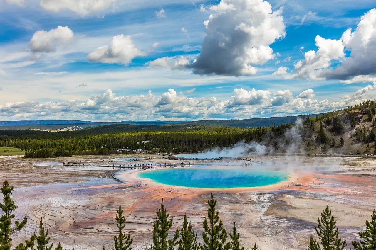
Few places on Earth force you to reckon with your own smallness quite like Yellowstone. You walk through what looks like a serene forest and suddenly there are boiling pools, geysers erupting on schedule, and the ground is literally breathing. That’s because Yellowstone doesn’t just have a volcano. Yellowstone is a volcano. A plume of molten rock that rises beneath the park creates one of the world’s largest active volcanoes, and you can see evidence all around in the form of geysers, hot springs, mud pots, and other otherworldly thermal features.
Geologic evidence suggests that Yellowstone has produced three colossal eruptions within the past 2.1 million years, with the eruptions occurring at gaps of about 600,000 to 800,000 years. The scale of those ancient events is truly staggering to think about. The first major eruption, which occurred 2.1 million years ago, is among the largest volcanic eruptions ever known, covering over 5,790 square miles with ash. The most recent major eruption, 640,000 years ago, caused the ground to collapse into the magma reservoir, leaving a giant caldera now measured at 30 by 45 miles.
Since its most recent major eruption approximately 640,000 years ago, Yellowstone has remained geologically active, primarily due to the vast magma chamber beneath the caldera, which is estimated to contain around 4,000 cubic kilometers of partially molten material, making it one of the largest of its kind globally. That is a genuinely terrifying number, though scientists consistently point out that an eruption is not considered imminent. Periodic uplift of the caldera floor, measured at rates of up to 75 millimeters per year, provides valuable insights into the dynamics of subterranean magma movement and is a key focus of ongoing geological monitoring.
Let’s be real: there is something both thrilling and unsettling about the fact that an area on the north rim of Yellowstone caldera, to the south of Norris Geyser Basin, started to uplift slightly in July 2025, with similar deformation having occurred in the same area during 1996 to 2004. Scientists continue to watch Yellowstone’s every twitch and rumble. Research shows that very distant earthquakes reach and affect Yellowstone’s activities, such as a 2002 magnitude 7.9 earthquake in Alaska that altered the activity of many geysers and hot springs for several months afterward. The interconnected nature of the Earth’s geological systems revealed here is nothing short of extraordinary.
Devils Tower, Wyoming: A Columnar Giant With a Story Nobody Fully Agrees On
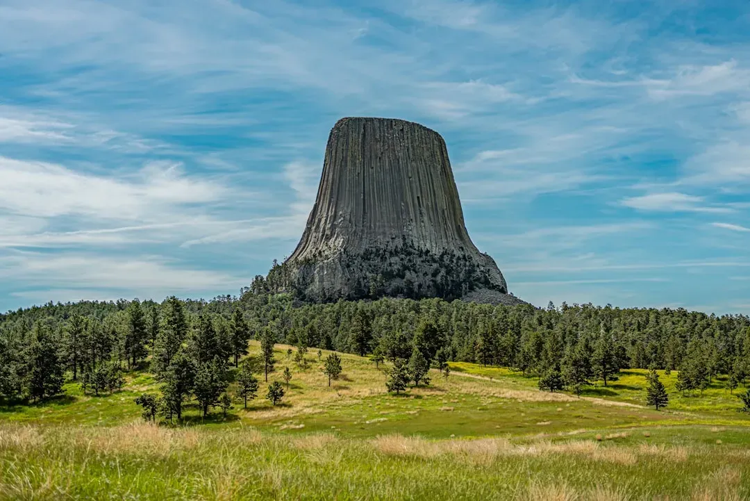
You drive across the open grasslands of northeastern Wyoming and suddenly, rising from the earth like something dropped from another dimension, there it is: Devils Tower. No gradual buildup, no surrounding mountain range. Just a solitary, ribbed column of rock shooting straight into the sky. Devils Tower is a laccolithic butte composed of igneous rock in the Black Hills region, rising 1,267 feet above the Belle Fourche River and standing 867 feet from summit to base. It was the very first site declared a United States national monument, by President Theodore Roosevelt in 1906.
The igneous material that forms the tower is a phonolite porphyry intruded about 40.5 million years ago, a light to dark gray or greenish-gray igneous rock with conspicuous crystals of white feldspar. As the magma cooled, hexagonal columns formed, sometimes four, five, and seven-sided, up to 20 feet wide and 600 feet tall. Think of it like a giant bundle of pencils, bound together by the physics of cooling rock. The columns are the result of contraction as the molten material solidified, and the geometry they produce is extraordinary.
Here’s where it gets genuinely fascinating. For roughly 95 percent of its existence, the entire block lived belowground, formed by molten lava that welled up into a layer of sedimentary rock 50 million years ago. Starting about 1 to 2 million years ago, rain and snowmelt slowly washed away the surrounding sandstone, siltstone, and shale, leaving the much sturdier mass behind. Essentially, erosion did not destroy Devils Tower. It revealed it. Devils Tower is a steep-sided igneous monolith recognized worldwide for a spectacular geologic feature known as columnar jointing, and it is the most widely known landmark of the northern Great Plains.
I think what makes Devils Tower so captivating is that even now, there is still significant debate around exactly how the formation process took place. Geologists have proposed multiple competing theories, from volcanic neck to laccolith to igneous intrusion, and none has been universally accepted. As rain and snow continue to erode the sedimentary rocks surrounding the tower’s base, more of Devils Tower will be exposed, though the exposed portions still experience their own erosion. The tower you see today is not the tower your great-grandchildren will see. It is slowly, imperceptibly, still being born.
Carlsbad Caverns, New Mexico: Caves Born From Acid Rising Out of an Oil Field
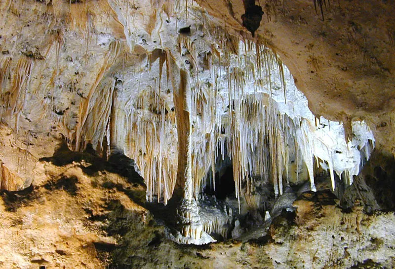
Most caves are formed the same way: rainwater absorbs carbon dioxide, turns mildly acidic, and slowly dissolves limestone from the top down. Carlsbad Caverns did not get that memo. The caves in Carlsbad Caverns are unusual as they formed from sulfuric acid instead of carbonic acid. Most caves form when water interacts with carbon dioxide and seeps downwards. However, Carlsbad Caverns National Park is located near the Permian Basin, which hosts large oil fields, and hydrogen sulfide-rich water rose from those oil reservoirs as late as 12 million years ago and mixed with groundwater to form sulfuric acid. The limestone was dissolved at the water table, meaning Carlsbad Caverns was dissolved from below, not from above.
The area where Carlsbad Caverns is located today was the coastline of an inland sea 250 million years ago. Due to the warm, shallow, tropical seas, the reef formed from mostly sponges and algae instead of coral, like many reefs today. That ancient tropical reef eventually became the limestone now riddled with some of the most spectacular underground chambers in the world. These caverns formed four to six million years ago as hydrogen sulfide gas migrated upward from nearby petroleum deposits into the 265-million-year-old Permian reef limestones, and the caves are uniquely ornamented with intricate calcium carbonate and calcium sulfate mineralization.
The park contains more than 100 known caves, including the nation’s deepest limestone cave at 1,604 feet and third longest. Carlsbad Cavern, with one of the world’s largest underground chambers, displays an amazing array of cave and karst features. The Big Room alone is colossal enough to swallow several city blocks whole. Speleothems including stalactites and stalagmites are formed from dissolved limestone, with rain and snowmelt soaking through the rock and absorbing gases and minerals. When this water evaporates and emits carbon dioxide, calcite remains and slowly builds up over time, with stalactites forming on the ceiling and water falling to the floor depositing minerals to create stalagmites. These formations take thousands of years to grow and remain among nature’s most patient and precise works of art.
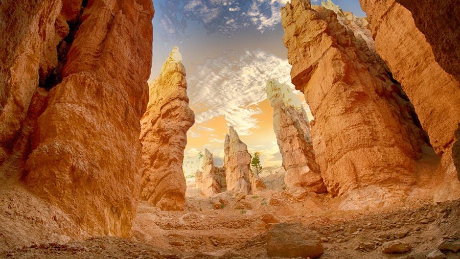
Antelope Canyon, Arizona: Where Flash Floods Sculpted Something That Looks Like a Dream
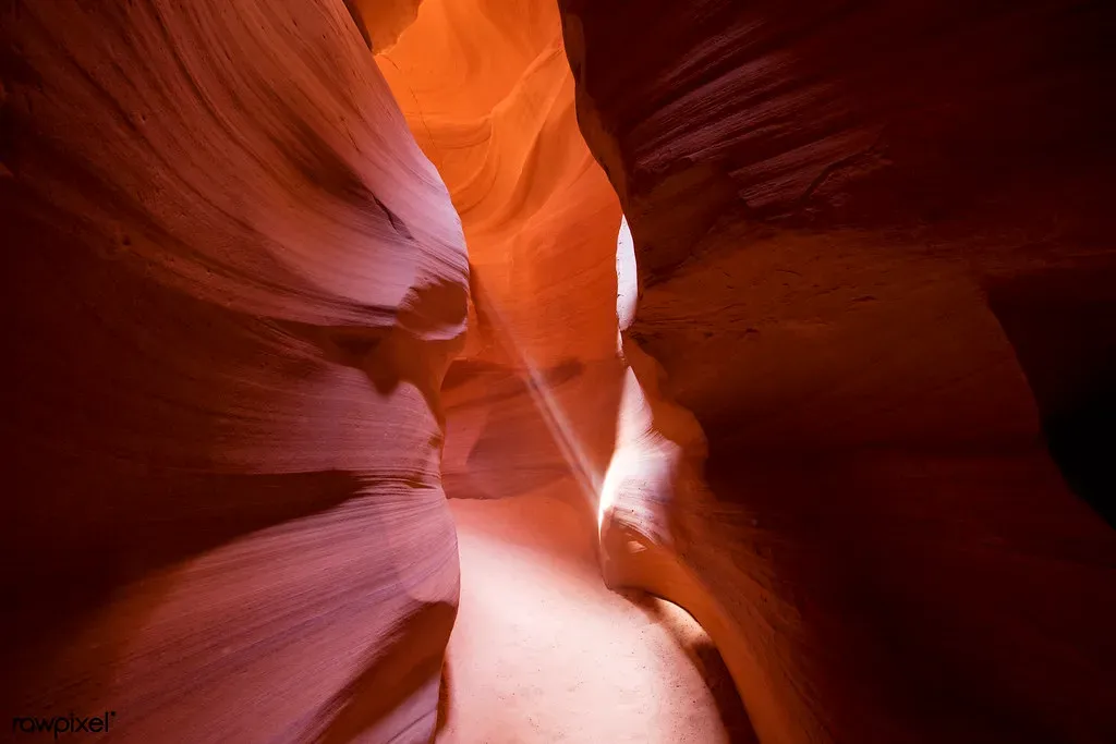
There are geological wonders you respect from a distance. Antelope Canyon is the kind of place that wraps itself around you. Its curving walls glow orange and burgundy, and narrow beams of sunlight filter down through the openings above like something out of a painting. The canyon was formed over thousands of years by the erosion of Navajo sandstone, resulting in narrow passageways with smooth, flowing walls. The interplay of light and shadows creates a surreal and magical atmosphere, and light beams often filter through the narrow openings above, illuminating the canyon floor with a vibrant array of colors.
At the heart of Antelope Canyon’s story is the Navajo Sandstone, formed from the compacted sands of ancient deserts, dating back to the Jurassic Period around 190 million years ago. Over millennia, these dunes solidified into rock, setting the stage for the canyon’s formation. The uniformity and softness of Navajo Sandstone made it particularly susceptible to the forces of erosion, which played a pivotal role in sculpting Antelope Canyon. What you’re looking at when you walk through it, in other words, is ancient desert dune become solid rock, then carved open again by water.
The Colorado Plateau, where Antelope Canyon is located, has undergone uplift, a process where the Earth’s crust rises. This uplift increases the gradient of streams and rivers, accelerating erosion. The uplift of the Colorado Plateau was therefore a significant factor contributing to the rapid and intense erosional processes that formed Antelope Canyon. Flash floods did the detail work. Flash floods in particular rapidly alter the canyon’s interior. During monsoon storms, water rushes through, eroding the sandstone and deepening the canyon. These floods can also create new formations and smooth out existing surfaces, while wind also transforms the canyon by carrying sand particles that abrade the rock surfaces.
For the Navajo people, the canyon holds spiritual importance and is intertwined with their history and folklore. The Navajo name for Upper Antelope Canyon, ‘Tse’ bighanilini’, means ‘the place where water runs through rocks,’ an apt description of its formation process. It is both a scientific record and a sacred space, and I think that duality makes it more fascinating, not less. Due to the delicate nature of the sandstone and the potential for flash floods, the canyon experiences ongoing changes, and erosion continues to shape and transform Antelope Canyon, making each visit a unique experience. You are never quite seeing the same canyon twice.
Conclusion
These five geological wonders are more than bucket-list destinations. They are chapters in a story the Earth has been writing since long before life as we know it existed. Each one reveals something fundamentally different about how this planet works. From the two-billion-year rock record of the Grand Canyon to the acid-carved darkness beneath New Mexico’s desert, these places speak to forces that dwarf human history entirely. Yet you can stand inside them, touch the walls, and feel connected to something immeasurably old.
The most humbling realization is that scientists are still actively unlocking the secrets held within each of these sites. Some of those secrets are being revised right now, in 2026, with better tools and fresher eyes. The Earth is still offering new pages to read. So if you ever get the chance to visit one of these wonders in person, take a moment to slow down. Look at the layers, the columns, the curved walls, and the steaming ground. You’re not just looking at rocks. You’re looking at time itself, preserved in a form you can actually stand next to. What would you have guessed was hiding beneath your feet all along?