America is carved, folded, scorched, and submerged in history. Billions of years of Earth’s most violent and elegant episodes are frozen right there in plain sight, written in stone across some of the most jaw-dropping landscapes on the planet. Yet most travelers drive right past them, heading to the same famous parks, the same scenic lookouts, the same Instagram spots.
Here’s the thing: the most mind-bending geological stories aren’t always found in the most crowded places. Tucked between Nevada’s dusty state lines, Colorado’s plunging canyon walls, and Idaho’s alien lava fields are national parks that will rewrite your understanding of time itself. You don’t need a geology degree to feel the awe. You just need to show up. Let’s dive in.
1. Capitol Reef National Park, Utah: The Great Wrinkle in the Earth
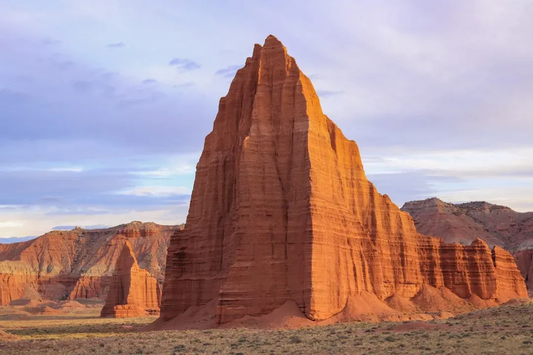
If you’ve only heard of Capitol Reef in passing, you’re missing something extraordinary. The park encompasses the Waterpocket Fold, a warp in the Earth’s crust that is 65 million years old, and it is the largest exposed monocline in North America. Think of it like pressing your hand flat on a tablecloth and pushing slightly forward. The tablecloth buckles. That is what happened here, only on a continental scale, and the results are breathtaking.
Capitol Reef’s geology can be traced back over 250 million years to the Permian period, when the park was covered by dunes with a climate and conditions most similar to those of the Saharan Desert today. Layer after geological layer, the story shifted from desert to swamp to shallow ocean and back again. Beyond the Waterpocket Fold, the park also contains classic elongated strike valleys, dikes and sills, intrusive gypsum domes, massive landslides, fossilized oyster reefs, petrified logs, dinosaur bones, bentonitic hills, and unusual soft-sediment deformational features. Honestly, this place reads like a geology textbook that somehow came to life.
2. Black Canyon of the Gunnison National Park, Colorado: The Abyss That Swallows Light
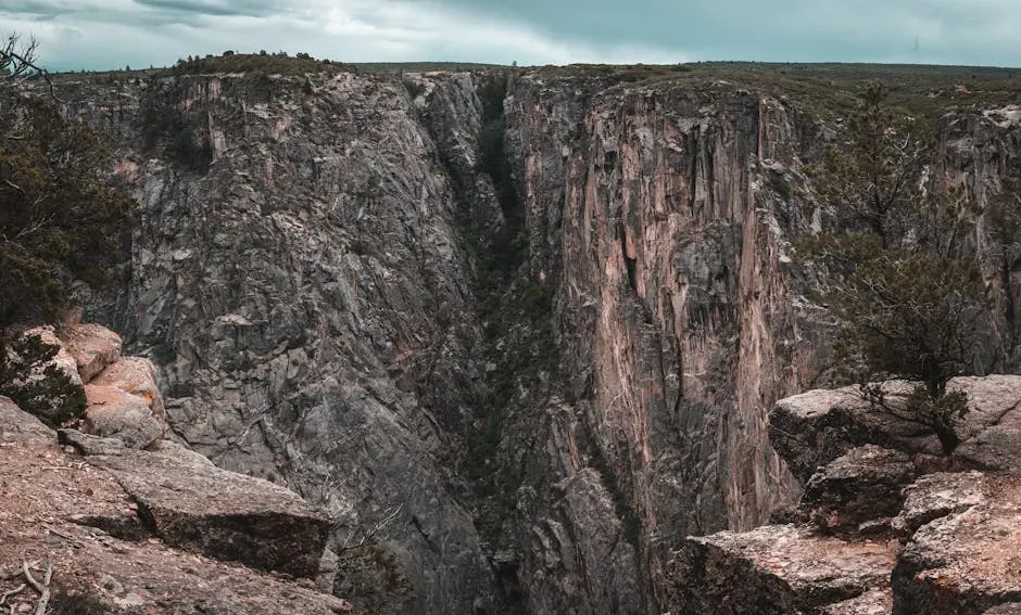
You won’t see this one coming. Literally. The Black Canyon is shocking in its suddenness – there are no mountains, spires, or wide-open canyons to alert you to its approach. Stopping at a park overlook and looking into a 2,000-foot canyon that was not visible just a few steps before is stunning. The canyon swallows your sense of scale whole.
The park is known for its incredibly narrow canyons, which were carved over millions of years by the Gunnison River cutting through approximately 1.7 billion-year-old Precambrian metamorphic rock. The iconic metamorphic rocks were formed almost two billion years ago during the Precambrian Era, when the Earth was a much more volatile place. Mafic and felsic rocks were buried deep in the Earth, and with burial came intense heat and pressure that altered these minerals by flattening and elongating the crystals, eventually turning them into the metamorphic rocks gneiss and schist. The Gunnison River then carved through all of it at a rate of roughly one inch per century. Slow, patient, and absolutely relentless.
3. Pinnacles National Park, California: Rocks That Traveled 200 Miles
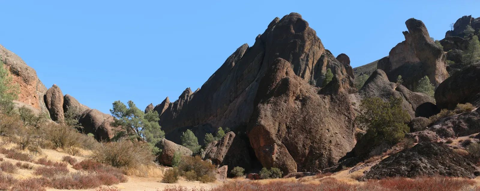
Most parks stay where they are. Pinnacles didn’t. Pinnacles used to be located about 200 miles south, near present-day Lancaster. The phenomenon responsible for its current location is the same one that caused the San Francisco earthquake of 1906. Tectonic forces along the San Andreas Fault moved Pinnacles’ rocks at a pace of a little more than half an inch per year over a period of 23 million years. Let that sink in. The rocks literally traveled, slowly and steadily, over geological eons.
Pinnacles’ namesake formations are jagged volcanic rocks that attract hikers and climbers alike, but learning where those rocks came from is what boggles the mind. When you stand beneath those towering spires, you’re technically standing on geological real estate that started its journey far to the south. It’s like finding out your house was quietly relocated while you weren’t watching. This is one of those places where the story behind the scenery is even more jaw-dropping than the scenery itself.
4. Wind Cave National Park, South Dakota: The Rarest Formations on Earth
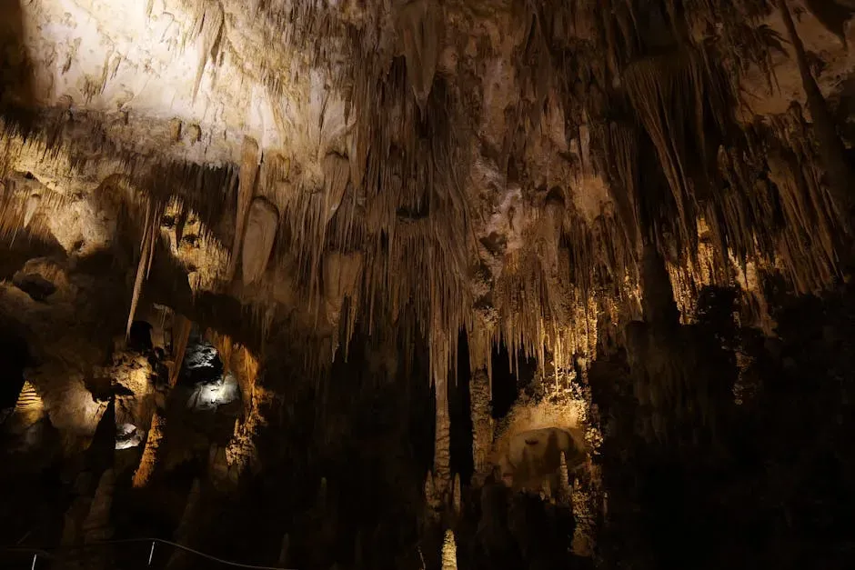
Most people visit Wind Cave for the cave tour and leave knowing surprisingly little about what they just witnessed. Boxwork may not be the most grandiose of cave formations, but it’s one of the rarest and most mysterious. The elaborate pattern of paper-thin veins of calcite on the ceiling of Wind Cave was named for its resemblance to the cubby holes in the local town’s post office. The prevailing theory is that the calcite was more resistant than the surrounding rock material, which wore away through dissolution and erosion, leaving behind these striking shapes.
Wind Cave is actually one of the longest and most complex cave systems ever discovered, with passages extending far beyond what’s currently mapped. The cave also features unusual formations such as cave popcorn and helictite bushes. Helictites, for those unfamiliar, are cave formations that defy gravity, growing in seemingly random, twisting directions. Science doesn’t have a fully satisfying explanation for all of them. I find that genuinely exciting. Some things still surprise us, even underground.
5. Craters of the Moon National Monument, Idaho: A Volcanic Landscape Frozen in Time
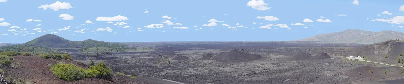
The name says it all, almost. The unearthly landscape formed by this lava field appears so foreign and grim it earned the name “Craters of the Moon.” The basaltic lava that formed the flow spilled out of the volcanically active Great Rift that runs through the monument. When you walk across it, the ground crunches and shifts under your feet in a way that feels profoundly alien, like visiting another planet that decided to park itself in central Idaho.
The monument is somewhere between 2,000 and 15,000 years old, practically fresh in geologic terms, and contains nearly every volcanic rock formation possible: cinder cones, lava rivers, lava tubes, spatter cones, tree molds, and nearly endless lava beds. Between 2,000 and 15,000 years ago, molten lava repeatedly broke through a series of cracks in the earth’s crust, flowing out in smooth, ropy streams for as much as 45 miles before hardening. Occasionally, chunks of rock blasted out with explosive force, creating a patchwork of jagged boulder fields. Geologists believe the area will likely erupt again in the future, which makes standing on it feel slightly more thrilling.
6. Devils Postpile National Monument, California: Nature’s Geometric Masterpiece
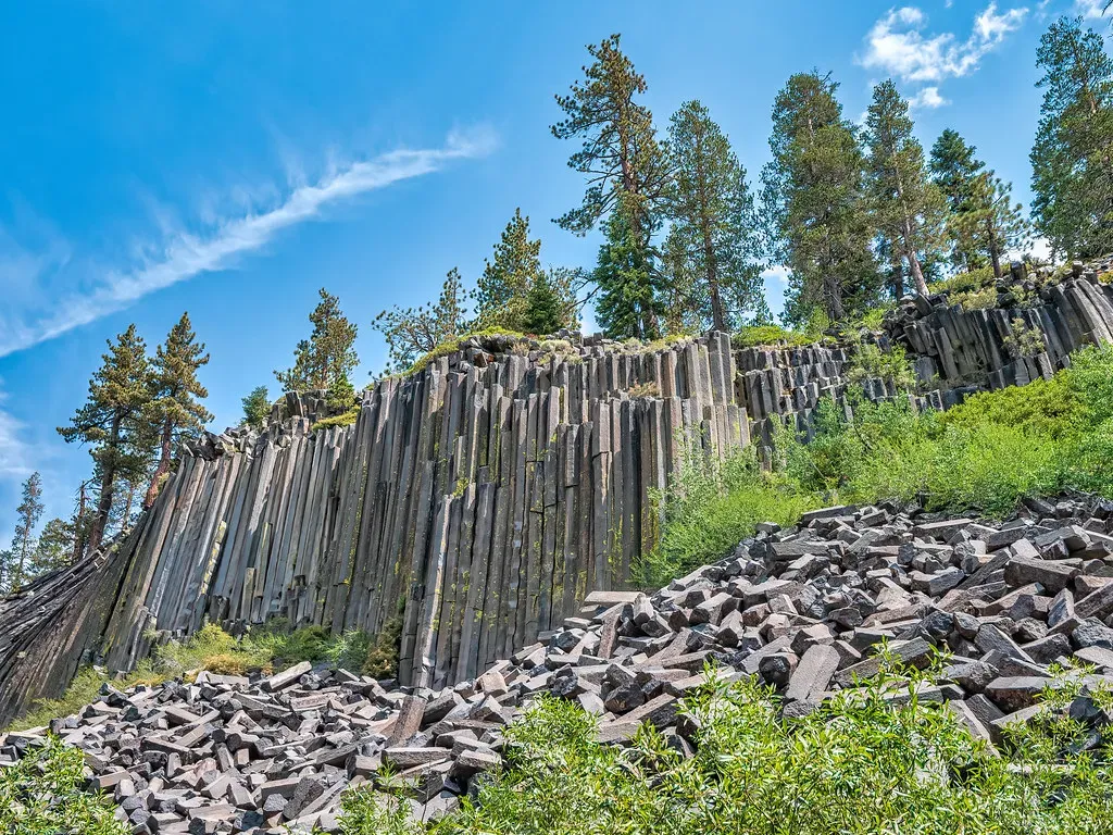
If you’ve ever stared at a honeycomb and marveled at how bees figured out hexagons, wait until you see what a volcano did in California. The famed hexagonal columns of basalt, some rising 60 feet, fit together with the uniformity and precision of expert masonry. The seminal event was a volcanic explosion about 100,000 years ago that unleashed a torrent of exceptionally hot, runny lava southeast of present-day Yosemite. The molten river hit a barrier, probably a glacial moraine, and pooled into a lake some 400 feet deep. The lava shrank as it cooled, and pressure cracked the young rock into hexagons, the shape that offers the greatest stress relief with the fewest cracks.
Then the ice age got involved and made things even more interesting. Ice age glaciers sheared off the column tops and polished the remaining rock to a high gloss. So what you’re looking at today is a two-act geological performance: first, an ancient volcano shaped the stone into perfect geometry; then a glacier came along and polished it. The saga behind Devils Postpile National Monument has a simple plotline: given the chance, nature creates order out of chaos. That line has never felt truer.
7. Bryce Canyon National Park, Utah: The Inverted Hoodoos That Break the Rules
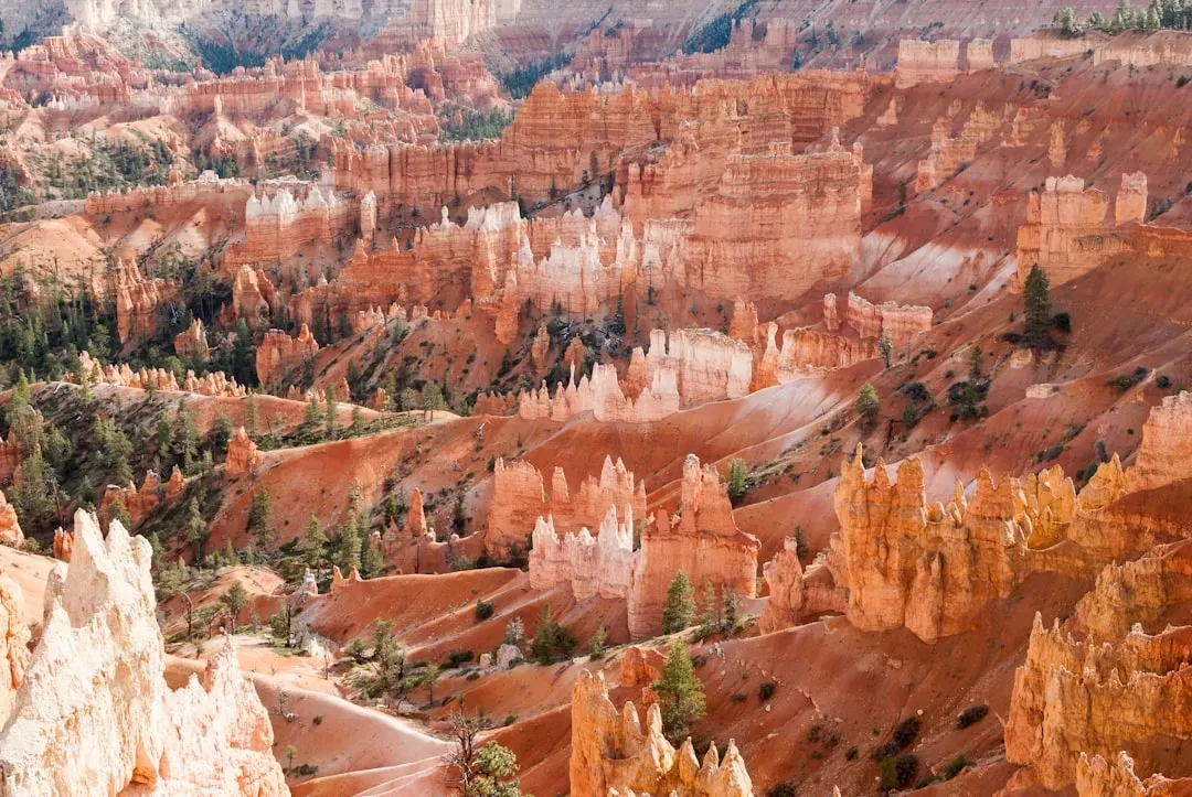
You’ve probably seen photos of Bryce Canyon’s famous hoodoos, those spindly, otherworldly rock spires rising from brilliant orange amphitheaters. Bryce Canyon is renowned for its unique hoodoos, tall, thin spires of rock formed by frost weathering and stream erosion. Despite its name, Bryce isn’t a true canyon but a collection of natural amphitheaters along the Paunsaugunt Plateau. These vibrant formations, ranging in color from red to orange to white, create an otherworldly landscape.
Here’s the part most visitors never learn. While most of the hoodoos at Bryce and in the world have younger rocks on top, the park includes a few examples of “inverted hoodoos” where the harder rock is actually older than the softer rock underneath. How did that happen? Tectonic forces pushed blocks of older rock over the younger layers before erosion took place. It’s geology in full defiance of expectation. The rules of rock formation, already complex, get turned quite literally upside down here.
8. Petrified Forest National Park, Arizona: A Forest Frozen in Stone
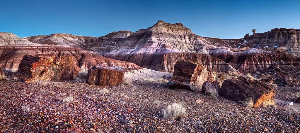
Imagine a forest so ancient that its trees have literally turned to crystal. That’s not a metaphor. In the Painted Desert of Arizona, there is a collection of 225-million-year-old petrified wood that has become almost solid quartz. This section of the Chinle geological formation is known scientifically for its globally significant Late Triassic fossils. These logs were once living trees, towering over landscapes that looked nothing like the desert you see today.
Rock layers in the area reveal ancient climates as varied as rivers and swamps, Sahara-like deserts, and shallow ocean. Each layer is a different chapter in Earth’s autobiography, and you are walking through all of them simultaneously. There are also over 350 Native American sites recording more than 13,000 years of human history and culture, as well as one of the most diverse collections of prehistoric pottery fragments in the Southwest. It’s a place where geology and human history overlap in ways that make you feel genuinely small in the best possible way.
9. Big Bend National Park, Texas: Half a Billion Years of Complex Story
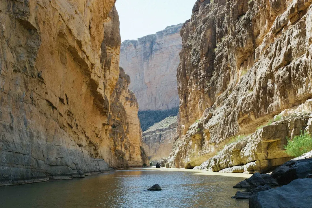
Most people think of Big Bend as a remote wilderness destination, a place for solitude and stargazing. Both of those things are absolutely true. What’s less talked about is the geology. Big Bend National Park offers a multitude of rock formations. Sparse vegetation makes finding and observing the rocks easy, but they document a complicated geologic history extending back 500 million years. That’s not a typo. Five hundred million years.
They say everything in Texas is larger than average, and this place is no exception. Where the Rio Grande River makes its wide turn through the Chihuahuan Desert, a whole host of delight is revealed. This is a world-class geological area, with laccoliths, faults, volcanoes, and remarkable fossils including a world-record pterosaur and a 50-foot crocodile. A 50-foot crocodile. Found in Texas. The geology here doesn’t just tell Earth’s story; it tells the story of creatures that make today’s wildlife seem almost quaint by comparison.
10. Zion National Park, Utah: 250 Million Years Written in Sandstone Walls
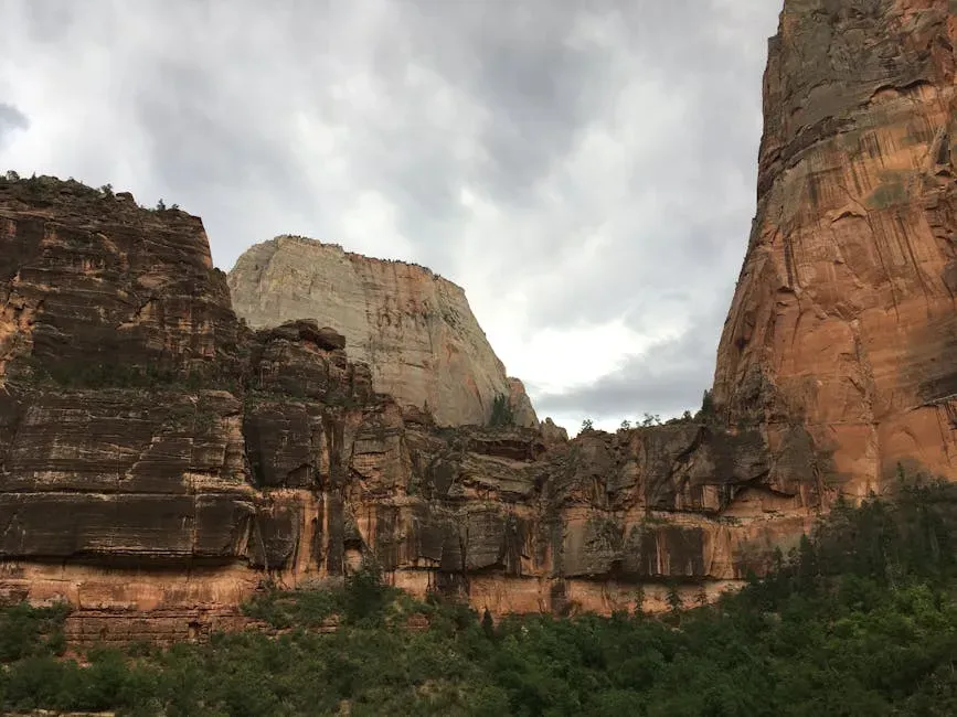
Zion gets a lot of visitors, so it might not feel like a hidden gem at first glance. Yet its geology remains genuinely underappreciated by the majority of people walking its trails. The geological story of Zion National Park spans millions of years, with each layer of rock revealing a different chapter in Earth’s history. The park’s rock formations date back as far as 250 million years, offering a glimpse into ancient ecosystems and long-extinct creatures. You’re not hiking through a canyon. You’re reading a library.
One of the most fascinating aspects of Zion’s geology is the presence of Navajo sandstone, which was deposited during the Jurassic Period when much of the region was covered by vast desert dunes. Most of the sedimentation that went into Zion’s geologic basement occurred during the age of dinosaurs, while the uplift began in the Cenozoic, long after the sedimentary formations were laid down. The park is located along the edge of a region known as the Colorado Plateau. The rock layers have been uplifted, tilted, and eroded, forming a feature called the Grand Staircase, a series of colorful cliffs stretching between Bryce Canyon and the Grand Canyon. The bottom layer of rock at Bryce Canyon is the top layer at Zion, and the bottom layer at Zion is the top layer at the Grand Canyon. Three different parks. One continuous, connected geological timeline. That is nothing short of extraordinary.
Conclusion: The Earth Is Still Talking

There’s something quietly humbling about standing in front of a canyon wall that is 1.7 billion years old, or touching a petrified log that was once a living tree in a Triassic forest. These parks don’t just preserve landscapes. They preserve time. And all you have to do is show up to experience it.
The ten places in this article represent some of the most geologically significant, scientifically fascinating, and visually astonishing destinations in the entire national park system. Many of them sit just off the beaten path, waiting for curious visitors who are willing to look a little closer and think a little deeper. The rocks have been patient for millions of years. They can wait for you too.
So next time you’re planning a trip and you feel the pull of the familiar, consider pointing your compass somewhere a little less crowded. The hidden geological gems of America’s national parks won’t disappoint. Which of these ten would you put at the top of your list?