Imagine standing on a single landmass so vast it stretched from one pole to the other, with no ocean separating what we now call South America from Africa, or Europe from North America. The world looked absolutely nothing like the maps you know. It was wilder, hotter, and in constant geological motion – a slow-motion demolition derby of continental plates that just happened to take hundreds of millions of years.
This is the world that dinosaurs called home. Every mountain that rose, every shallow sea that flooded a continent, every rift valley that split the land apart – all of it shaped where dinosaurs lived, how they evolved, and ultimately, what fate awaited them. Let’s dive in to a geological journey unlike any other.
Pangaea: The One Continent That Started It All
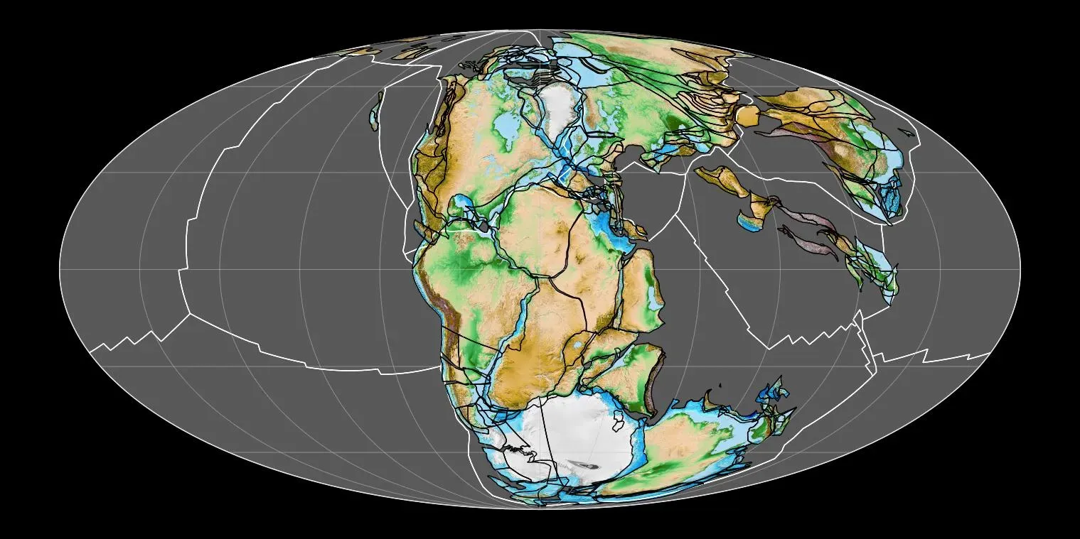
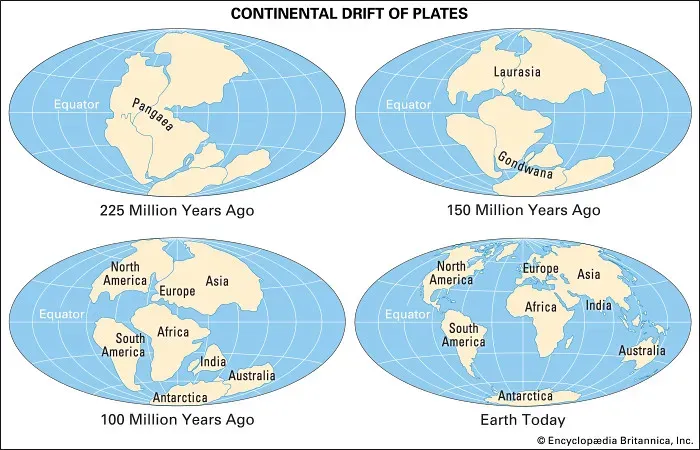
At the beginning of the age of dinosaurs, during the Triassic Period about 230 million years ago, the continents were arranged together as a single supercontinent called Pangea. Think of it like one gigantic puzzle where every piece was still locked together. There were no Atlantic crossings, no Pacific barriers. If you were a land animal, the whole world was yours to roam.
Pangaea was a supercontinent that existed during the late Paleozoic and early Mesozoic eras, assembled from the earlier continental units of Gondwana, Euramerica, and Siberia during the Carboniferous period approximately 335 million years ago, and began to break apart about 200 million years ago, at the end of the Triassic and beginning of the Jurassic. Honestly, the scale of this thing is hard to wrap your head around. It wasn’t just a large continent – it was essentially the entire landmass of Earth fused into one.
Because much of the land that constituted Pangaea was distant from the oceans, temperatures fluctuated greatly, and the interior of Pangaea probably included expansive areas of desert. So despite this romantic idea of a lush, connected world, the reality for early dinosaurs was often brutally dry. Life clung to the coastal fringes and river systems, and the harsh interior was far less hospitable than we might imagine.
The Triassic Rift: When the World Began to Crack
Pangea began to break up toward the end of the Triassic, first along the boundary between North America and Africa. The original continental boundary wasn’t exactly reproduced; instead, North America gained a chunk of land that today includes Florida and nearby parts of the southeastern United States. As the two continents began to move in different directions, long narrow rift valleys formed along the seam. It’s a fascinating thought – the peninsula of Florida essentially started its geological life on the African side of the planet.
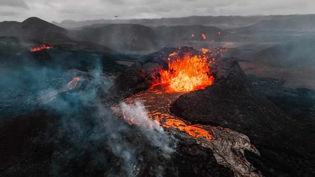
At the very end of the Triassic, approximately 201 million years ago, huge amounts of lava erupted over a short time along the boundary from southwest Europe to northeast South America as what is now the North Atlantic began to open. The breakup of Pangea was in full swing, but would not be complete until much later. These volcanic events were catastrophic in scale. The rifting didn’t just reshape geography – it pumped enormous amounts of gas into the atmosphere, altering the very climate that dinosaurs depended on for survival.
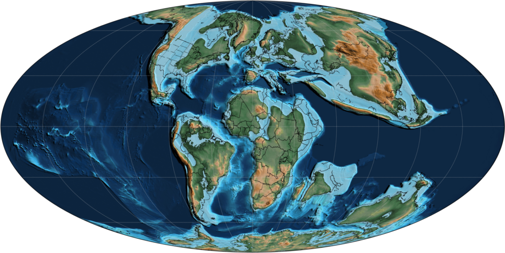
Laurasia and Gondwana: A World Split in Two
The era featured the dramatic rifting of the supercontinent Pangaea, which gradually split into a northern continent, Laurasia, and a southern continent, Gondwana. Think of it as the world’s most destructive divorce. Two giant landmasses drifting apart, with the ancient Tethys Sea rushing in to fill the gap between them. The animals living on each half were about to be sent on very different evolutionary journeys.
Gondwana – comprising what would become South America, Africa, Antarctica, Australia, and India – started fragmenting during the middle Jurassic period. The breakup wasn’t uniform; different regions separated at different times, creating a complex puzzle of continental drift. The separation of Gondwana created isolated dinosaur populations across the southern hemisphere. Each fragment carried its own complement of dinosaur species, which then evolved in isolation for millions of years. This is where things get truly remarkable. Isolation is nature’s great experiment. Cut a population off from its relatives, and evolution starts drawing its own entirely new blueprints.
The Tethys Sea and Its Climate Power
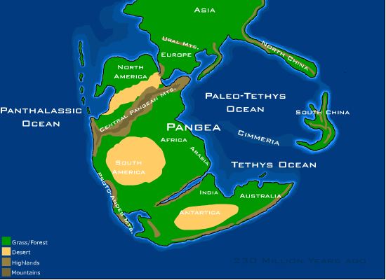
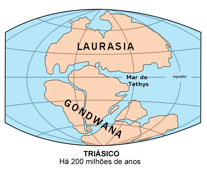
Centered on the equator and stretching from pole to pole, Pangaea was shaped roughly like a large capital ‘C,’ and within the cradle lay a separate body of water known as the Tethys Ocean. During the Jurassic Period, shifting continents compressed the Tethys to form an equatorial seaway stretching from today’s Caribbean Islands to what is now the Himalayas. Here’s the thing – most people never consider how a single ocean can be responsible for regulating the entire planet’s temperature. The Tethys was basically Earth’s thermostat during the age of dinosaurs.
The connected seas of the Tethys, Atlantic, and Pacific in the tropics allowed for equatorial waters to circulate freely in the Late Jurassic and Cretaceous, a system that sustains warmer global temperatures and discourages icecap formation. The closure of the Tethys Sea was significant in obstructing this circum-equatorial flow. Whether the tropical effect of this ocean gateway played a role in the enormous size attained by dinosaurs is still uncertain, but it is an area of intense study. I think that last point is underappreciated. Could an ocean’s current system be partly responsible for producing the largest land animals in Earth’s history? The evidence is tantalizing.
Rising Seas and the Jurassic Transformation
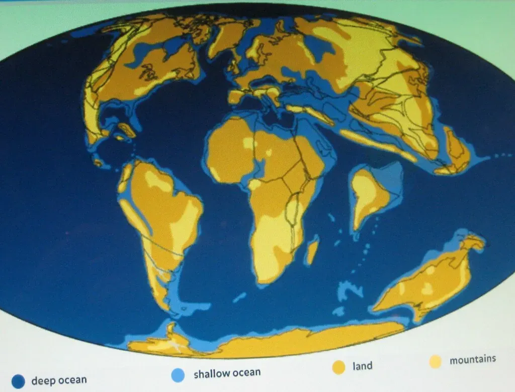
Sea levels began to rise during the Jurassic, which was probably caused by an increase in seafloor spreading. The formation of new crust beneath the surface displaced ocean waters by as much as 200 m more than today, which flooded coastal areas. Furthermore, Pangaea began to rift into smaller divisions, bringing more land area into contact with the ocean by forming the Tethys Sea. That figure is staggering. Over 600 feet more ocean water than we have today, lapping at continental edges and rewriting the map entirely. Coastlines that exist today would have been hundreds of miles underwater.
The breakup of Pangaea that began in the Triassic continued in the Jurassic, and the early Atlantic Ocean and the Gulf of America appeared as shallow continental seas. Shallow inland seas covered parts of the western United States. During the Jurassic, mudstone and sandstones were also deposited in lowland areas and river channels throughout the Rockies and Colorado Plateau; these formed the Morrison Formation, which is famous for its abundant dinosaur fossils. Those inland seas created lush, fertile habitats where the most iconic Jurassic giants – think giant sauropods – thrived and eventually left their bones for us to discover millions of years later.
The Cretaceous Breakup and Isolated Evolutionary Kingdoms
The Cretaceous Period was the longest of the three periods of the Mesozoic Era, spanning over 79 million years. During this period, the continents completely separated, causing dinosaurs and other life forms to evolve independently of each other. By this point, the planet looked far more recognizable, but the biological consequences of all this separation were profound. You essentially had separate evolutionary kingdoms, each developing their own spectacular and unique fauna.
Early dinosaur species that lived before major continental separations show wide geographic distributions, while later species are often restricted to specific continents or regions. The distribution of dinosaur fossils across continents that are now separated by vast oceans provides some of the strongest evidence for continental drift theory. For example, similar dinosaur species found in both South America and Africa indicate that these continents were once connected. As the continents drifted apart, the dinosaur lineages on each continent began to diverge, creating the distinct regional assemblages we see in the fossil record. Fossils, in this sense, are not just records of ancient life – they are a geological timeline written in bone.
The End of the World: Tectonics, Volcanism, and Extinction
The breakup of Pangaea could have contributed to an increase in polar temperatures as colder waters mixed with warmer waters, also accompanied by outgassing of large quantities of carbon dioxide from continental rifts. This produced a Mesozoic CO2 high that contributed to the very warm climate of the Early Cretaceous. Tectonic activity was not just a passive background feature – it was actively pumping greenhouse gases into the atmosphere, warming the planet to temperatures we simply don’t experience today. The dinosaurs evolved within this hothouse world, and any disruption to it carried enormous consequences.
The Cretaceous–Paleogene extinction event was a major mass extinction of three-quarters of the plant and animal species on Earth, occurring approximately 66 million years ago. The event caused the extinction of all of the dinosaurs and most other tetrapods weighing more than 25 kg, with the exception of some ectothermic species such as sea turtles and crocodilians. It marked the end of the Cretaceous period, and with it the Mesozoic era, while heralding the beginning of the current geological era, the Cenozoic Era. The asteroid impact is often given all the credit, but by the end of the Cretaceous, the world had already been destabilized by millions of years of tectonic change, volcanic activity, and sea-level shifts. The dinosaurs were living on borrowed geological time.
Conclusion: A Planet in Motion, A World in Transformation
You cannot fully understand the dinosaurs without understanding the ground beneath their feet. Every split in the land, every rising sea, every volcanic eruption along a rift zone was a chapter in the story of how these magnificent animals evolved, diversified, and spread across the globe. Plate tectonics was not just a geological backdrop – it was a living, breathing engine driving the entire drama of the Mesozoic world.
Understanding the relationship between continental drift and dinosaur evolution also provides valuable lessons for modern conservation biology. The same geographic and climatic processes that drove dinosaur diversification are still operating today, affecting the distribution and evolution of modern species. By studying how dinosaurs responded to continental breakup and climate change, we can better predict how modern ecosystems might respond to ongoing environmental changes.
The plates are still moving right now, even as you read this sentence. The world is not finished reshaping itself. When you look at a map of today’s continents, you’re really looking at just one frame in an epic film that began over four billion years ago – and the dinosaurs had one of the most dramatic scenes in the entire story. What part of this geological journey surprised you the most? Tell us in the comments.