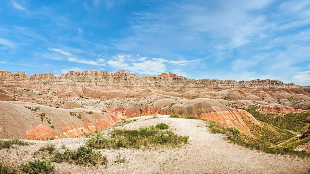
The Americas hold more buried history than you might think. Beneath the dense green canopy of the Amazon, under dry Peruvian desert plains, and hidden among the wetlands of Mexico’s Yucatán Peninsula, entire cities once stood – organized, engineered, and teeming with life. For centuries, these places were either forgotten entirely or dismissed by scholars convinced that the jungle was too hostile, or the terrain too remote, to have ever supported complex civilization.
What’s changed isn’t the landscape. It’s the tools we’re using to look at it. Laser technology fired from low-flying aircraft, artificial intelligence trained on satellite imagery, and decades of patient fieldwork are together rewriting the story of the ancient Americas in real time. The discoveries emerging from this convergence of old science and new technology raise as many questions as they answer – and that’s precisely what makes them worth paying attention to.
LiDAR: The Technology That’s Rewriting Archaeological History
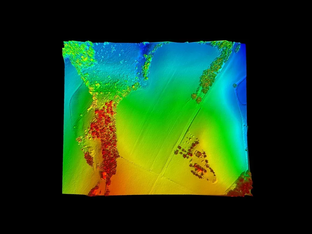
You’ve probably heard that technology is changing archaeology, but it’s worth understanding exactly how dramatic that change has been. LiDAR technology uses laser pulses to measure distances and create three-dimensional models of specific areas, allowing scientists to scan large swaths of land from the comfort of a computer lab and uncover anomalies in the landscape that often prove to be pyramids, family houses, and other examples of ancient infrastructure.
In the last few years, airborne LiDAR has increasingly been used by archaeologists. Although the technology dates back about 60 years, it has only recently become more accessible, with the first commercial systems appearing in the mid-1990s. One reason for this is decreasing cost, partly due to improvements in sensor technology. Systems have also become more compact, lightweight, and less power-hungry, so they can now be attached to drones – a more cost-effective option than using manned aircraft for mapping a small area.
While LiDAR saves time in the research process – in some cases one day in the air can replace a lifetime’s work of an archaeologist on the ground – the work it supports is still costly. Still, what it gives back in scale of discovery is extraordinary. Researchers who have hiked through jungles with machetes and compasses now report the embarrassing experience of having been standing very close to large stone pyramids without ever seeing them – only to find them clearly visible later in a LiDAR image.
Ecuador’s Upano Valley: The Oldest Urban Network in the Amazon
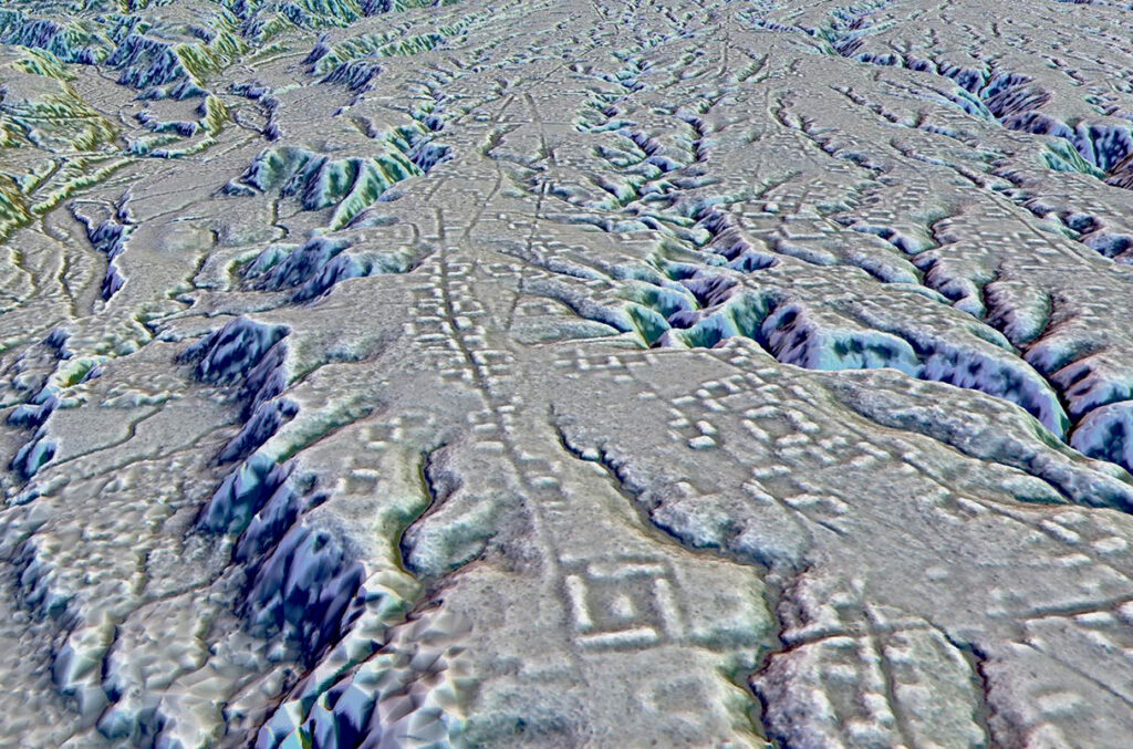
Findings published in the journal Science showcase a complex network of interconnected cities, roads, and agricultural structures dating back 2,500 years, making it the oldest and largest example of an agricultural civilization in South America’s Amazon rainforest. This discovery, centered on Ecuador’s Upano Valley, shifted what researchers believed was possible in one of the most biologically demanding environments on earth.
LiDAR imaging, a method using airborne lasers to penetrate the forest canopy, revealed more than 6,000 rectangular earthen platforms, plaza structures, and mounds connected by an extensive gridwork of straight roadways and footpaths. The settlements in the Upano Valley, including Sangay and Kilamope, exhibited a high degree of urban planning, with large mounds reaching up to 492 feet in length and 26 feet in height. The complexity of the site drew comparisons to Maya urban systems in Central America, challenging previous beliefs about the Amazon’s historical civilizations.
The team identified five large settlements and ten smaller ones across 300 square kilometers in the Upano Valley, each densely packed with residential and ceremonial structures. The cities are interspersed with rectangular agricultural fields and surrounded by hillside terraces where people planted crops, including corn, manioc, and sweet potato found in past excavations. Wide, straight roads connected the cities to one another, and streets ran between houses and neighborhoods within each settlement.
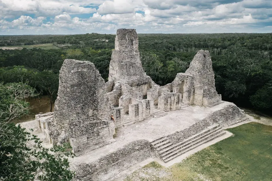
Ocomtún: A Forgotten Maya City Hiding in Plain Sight
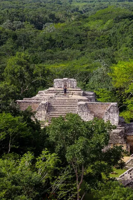
A once-forgotten city in the jungles of Campeche on Mexico’s Yucatán Peninsula was detected from the skies by LiDAR and contains pyramids, a ball court, and spaces marked out by unusual stone columns. Named Ocomtún – a word meaning “stone column” in Yucatec Maya – the site had spent more than a thousand years completely swallowed by the forest, unrecorded in any historical document.
Archaeologist Ivan Šprajc and his team were astounded by what they encountered in the heart of the jungle. The core of Ocomtún spans over 50 hectares and encompasses structures of monumental proportions, including a pyramid towering 25 meters high, numerous cylindrical stone columns, and a ball court – a testament to the city’s significance and its role as a regional center during the Maya Classic period. The site consists of three plazas surrounded by imposing buildings, with a group of low and long structures stretching out between the two largest plazas.
Scientists had already been forced to revise their estimates of the Maya population in 2018, following a round of LiDAR mapping work in Guatemala. Now it looks like those initial estimates of 11 million may need to be raised again. There had long been an assumption that this region’s landscape was simply not suitable and that very few people ever lived there – and what researchers are now discovering is that just isn’t true. It was always a matter of the lack of research.
The Campeche Revelation: Over 6,500 Hidden Maya Structures
Archaeologists have uncovered over 6,500 previously unknown Maya structures, including a hidden city with grand pyramids, within southeast Mexico. This major discovery highlights the impressive and populous ancient Maya landscape that had long been hidden beneath dense forests and modern settlements. What makes this find particularly striking is that some of it was discovered hiding in plain sight, right alongside farmland and modern roads.
The study focused on a roughly 50-square-mile area in east-central Campeche, an “unmapped” zone in Maya archaeology. By analyzing LiDAR data initially gathered in 2013 to monitor carbon in Mexico’s forests, researchers discovered a hidden expanse of Maya settlements. The fact that data collected for an entirely different scientific purpose ended up revealing an ancient civilization is itself a reminder of how much remains hidden in plain sight.
The study challenges previous assumptions about the Maya civilization by unveiling a picture of a more interconnected and urbanized society than previously known. While archaeologists have long understood that the Maya occupied and engineered vast tracts of land in the region, certain areas like east-central Campeche had largely escaped scientific attention. By focusing on this blank spot in Maya archaeology, the research team opened new doors to understanding the scope and organization of the ancient Maya.
Peru’s Nazca Desert: AI Doubles the Known Geoglyphs
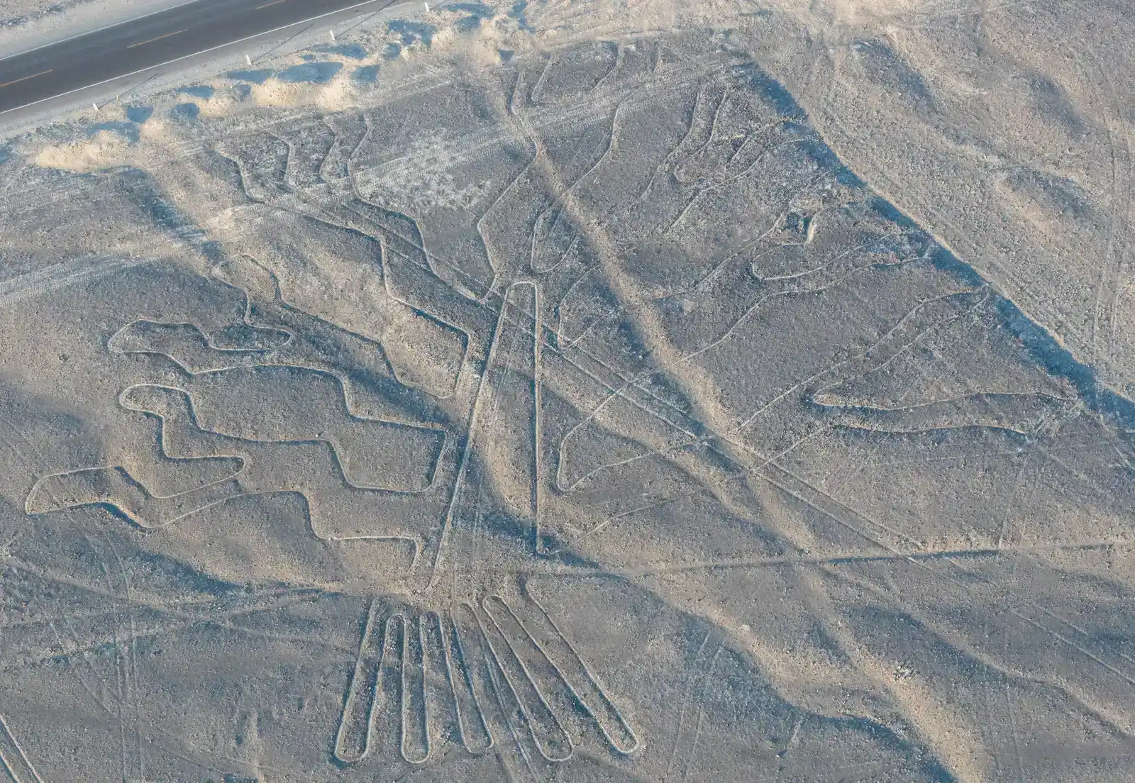
Archaeologists working in Peru, assisted by artificial intelligence, have discovered 303 previously unknown giant symbols carved in the Nazca Desert. The carvings include birds, plants, spiders, humanlike figures with headdresses, decapitated heads, and an orca wielding a knife. This discovery almost doubled the number of known Nazca geoglyphs, mysterious artworks formed in the ground by moving stones or gravel that date back some 2,000 years.
In just six months, the AI-assisted study identified 303 new geoglyphs, adding to the 430 that had been discovered over nearly a century. The speed of that finding is difficult to fully appreciate until you consider how slowly such work had gone before. The rate of discovery of new figurative Nazca geoglyphs had historically been on the order of about one and a half per year from the 1940s through the 2000s, accelerating somewhat due to the availability of remotely sensed high-resolution imagery from 2004 to 2020.
The main hypothesis for why the Nazca people made the symbols is that they formed a sacred space, perhaps a place of pilgrimage. Other theories propose they played a part in calendars, astronomy, irrigation, movement such as running or dancing, or communication. The debate remains open, but the new data at least gives researchers a far richer archive to work with than any previous generation of scholars ever had access to.
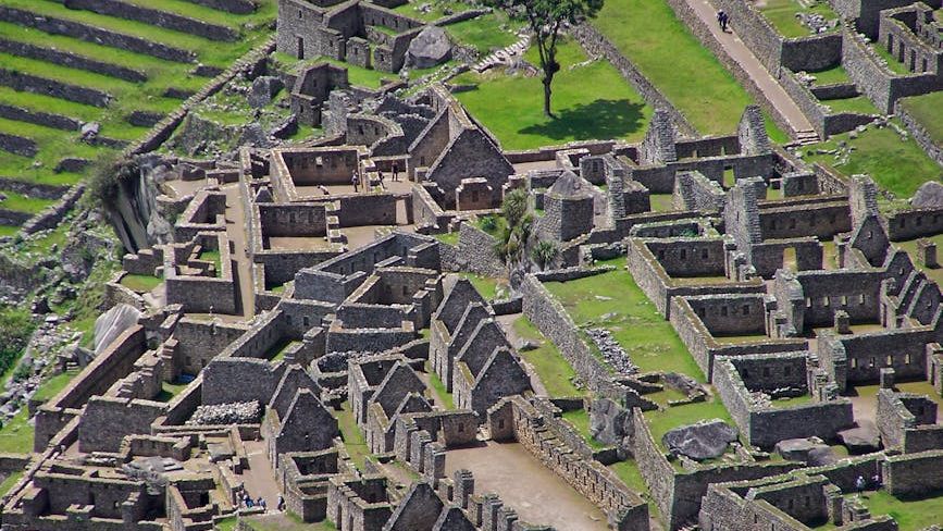
A 3,500-Year-Old City in Peru and What It Tells Us About Urbanization
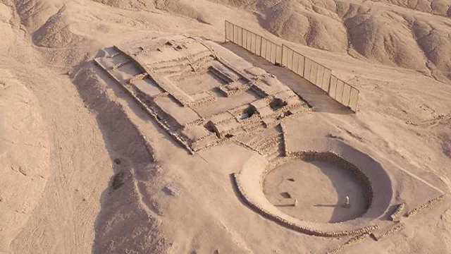
Archaeologists led by Ruth Shady uncovered a 3,500-year-old city in Barranca, Peru, making it one of the oldest known urban centers in South America. This 2025 discovery reveals residential areas, public spaces, and trade hubs that connected coastal and inland communities. Excavations have also unearthed clay sculptures of people and animals, ceremonial artifacts, and necklaces crafted from beads and seashells. These findings indicate a society rich in spiritual and cultural practices.
The Barranca settlement illustrates how humans used symbols, objects, and structured spaces to communicate and organize society. It also demonstrates that urbanization, administration, and symbolic culture developed simultaneously across diverse regions. You might expect that kind of complexity only in places associated with famous ancient civilizations, yet here it was, waiting patiently in coastal Peru for thousands of years before anyone went looking in the right way.
Ancient Amazonians pioneered advanced agricultural techniques, including composted gardens and terra preta, or “dark earth” – a highly fertile, human-enhanced soil created through composting food scraps and organic waste. Covering an estimated 154,000 square kilometers, nearly twice the size of Ireland, terra preta allowed civilizations to thrive in nutrient-poor rainforest soils. This kind of environmental engineering suggests a level of accumulated knowledge and long-term planning that fundamentally changes how we understand ancient life in the Americas.
What All These Discoveries Mean for the Future of Archaeology
The Amazon is considered the world’s most dangerous forest, with dense, towering trees, tangled vines, hostile wildlife, and poisonous insects. Archaeologists had believed it to be mostly suited for hunter-gatherers but an inhospitable place for complex civilizations. However, in the last two decades, scientists have found traces of human settlements in the Amazon, from Bolivia to Brazil, including mounds, hill forts, and pyramids.
The Amazon is also changing rapidly. Forests are being eliminated to promote farming, ranching, energy production, and the roads and dams that support such efforts. Many of those undisturbed areas, with their hidden records of past cultures, won’t remain so for long. There’s a real urgency behind the science, even if it rarely gets framed that way. Archaeologists aren’t just racing to satisfy intellectual curiosity – they’re trying to document what exists before it’s gone for good.
The current wave of discovery represents a roughly sixteen-fold acceleration in findings compared to earlier methods, using big geospatial data technologies and AI. This suggests AI may be at the brink of ushering in a revolution in archaeological discoveries like the revolution aerial imaging had on the field. What’s already been found, in just the past few years, would have seemed implausible to archaeologists working even two decades ago.
Conclusion
Every lost city that surfaces from beneath the jungle or desert floor carries the same quiet message: the past was far more populated, far more organized, and far more capable than the conventional story gave it credit for. The extent of landscape modification at sites like the Upano Valley rivals other ancient civilizations such as the Classic Maya, yet many questions remain unanswered, including population size, trade networks, and governance structures of the people who built them. That humility is worth holding onto.
The Americas were never empty. They were full of people who built roads, planned cities, managed water, and made art large enough to be seen from the sky. Archaeologists once believed the ancient Amazon rainforest was an inhospitable place, sparsely populated by bands of hunter-gatherers. The remains of enormous earthworks, pyramids, and roads from Bolivia to Brazil discovered over the past two decades have proved conclusively that the Amazon was home to large, complex societies long before European colonizers arrived. What we’re really doing now is beginning to listen to what those societies left behind – and we’re only just getting started.