Imagine standing at the edge of a canyon that stretches further than your eye can reach, its walls carved not by millions of patient years of erosion, but by a single catastrophic wall of water roaring through in a matter of days. Sounds almost impossible, right? Yet this is exactly what happened across vast stretches of our planet during the end of the last great Ice Age. The Earth we walk on today, with its dramatic valleys, towering dry waterfalls, and scarred plains, is in many ways a direct monument to some of the most staggering flood events our world has ever known.
These weren’t floods you could outrun. They weren’t floods you could even comprehend while standing in their path. They were planet-altering, landscape-sculpting, culture-inspiring catastrophes that continue to echo across geology, mythology, and even space science. So buckle up, because the story of prehistoric mega-floods is one of the most spectacular, humbling, and honestly jaw-dropping chapters in the entire history of our planet. Let’s dive in.
What Exactly Is a Mega-Flood, and Why Should You Care?
Here’s the thing – when scientists talk about prehistoric mega-floods, they’re not describing the kind of flooding you see on a weather report. In geomorphology, an outburst flood, a type of megaflood, is a high-magnitude, low-frequency catastrophic flood involving the sudden release of a large quantity of water. We’re talking about events so massive that they reshaped entire regions of the planet in a matter of hours or days, not centuries. Think of it less like a river overflowing its banks and more like an inland sea being poured out across a continent.
Megafloods are paleofloods, meaning past floods, that involved rates of water flow larger than those in the historical record. They are studied through the sedimentary deposits and the erosional and constructional landforms that individual megafloods created. In other words, the geological record itself becomes the crime scene, and geologists are the detectives. Every carved canyon, every oversized boulder dropped far from its origin, every ripple mark frozen in rock – all of it is evidence left behind by these ancient walls of water.
The Missoula Floods: North America’s Most Dramatic Ice Age Catastrophe
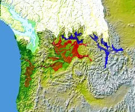
About 15,000 years ago, in the waning millennia of the Ice Age, a vast lake known as Glacial Lake Missoula suddenly burst through the ice dam that plugged it at one end. In the space of just 48 hours, geologists believe, the collapse sent 500 cubic miles of water cascading across the Pacific Northwest, creating overnight such unusual landscapes as the scablands of eastern Washington State. Let that sink in. Five hundred cubic miles of water, moving faster than most people drive on a highway, redesigning an entire region in two days.
After analysis and controversy, geologists now believe that there were 40 or more separate floods, although the exact source of the water is still being debated. The peak flow of the floods is estimated to be 27 cubic kilometers per hour. The maximum flow speed approached 36 meters per second, or about 80 miles per hour. To put that speed into context, the water was moving as fast as many interstate highways allow cars to travel. Each flood released energy equivalent to 4,500 megatons of TNT, which is 90 times more powerful than the most powerful nuclear weapon ever detonated, the Tsar Bomba. I know it sounds crazy, but that’s exactly what the numbers say.
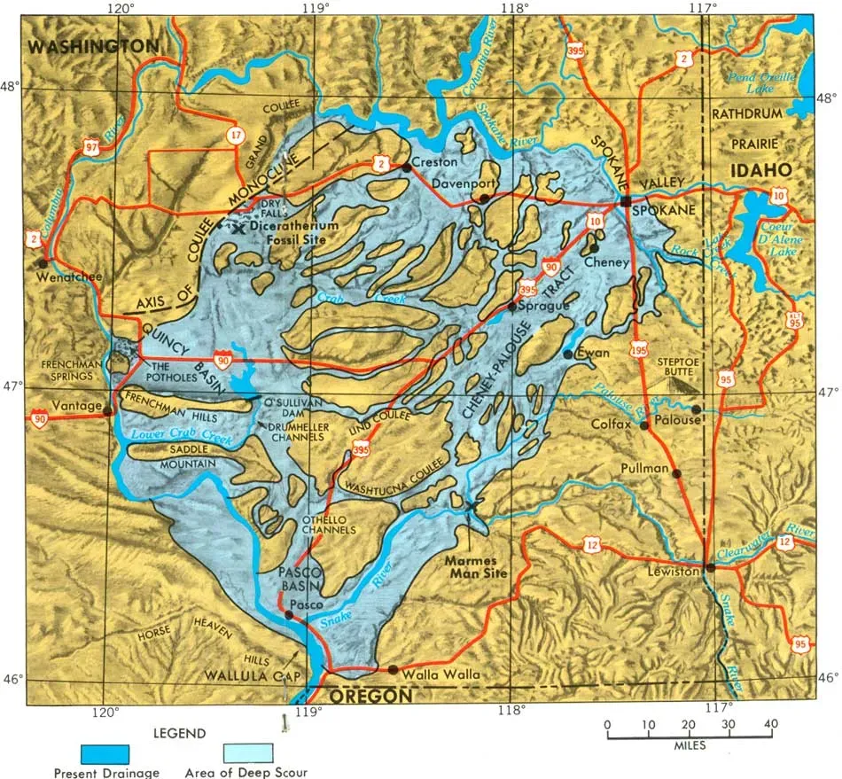
The Channeled Scablands: A Landscape Written in Water

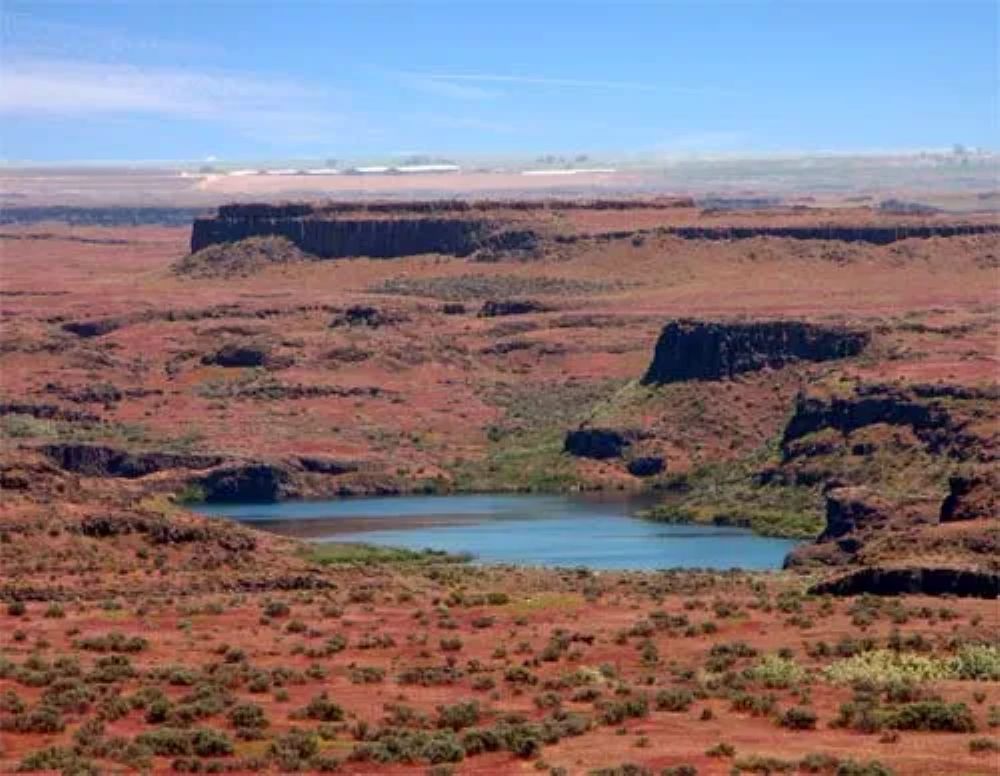
As ice sheets began melting at the end of the last ice age, a series of cataclysmic floods called the Missoula megafloods scoured the landscape of eastern Washington, carving long, deep channels and towering cliffs through an area now known as the Channeled Scablands. You can still visit this eerie, otherworldly terrain today, and standing in it you genuinely feel the ghost of something enormous. Littered with steep canyons hundreds of feet deep, dry falls, and massive potholes, the geological artifacts tell the tale of a land that was once subject to titanic forces.
In the middle of eastern Washington, in a desert that gets less than eight inches of rain a year, stands what was once the largest waterfall in the world. It is three miles wide and 400 feet high, ten times the size of Niagara Falls, with plunge pools at its base suggesting the erosive power of an immense flow of water. Today it’s called Dry Falls, and it carries no water whatsoever. The Scablands are littered with large boulders called glacial erratics that rafted on glaciers and were deposited by the glacial outburst flooding. The lithology of erratics usually does not match the rock type that surrounds them, as they are often carried very far from their origin. Those misplaced boulders, sitting alone in strange places, are perhaps the most visually haunting reminder of what once happened here.
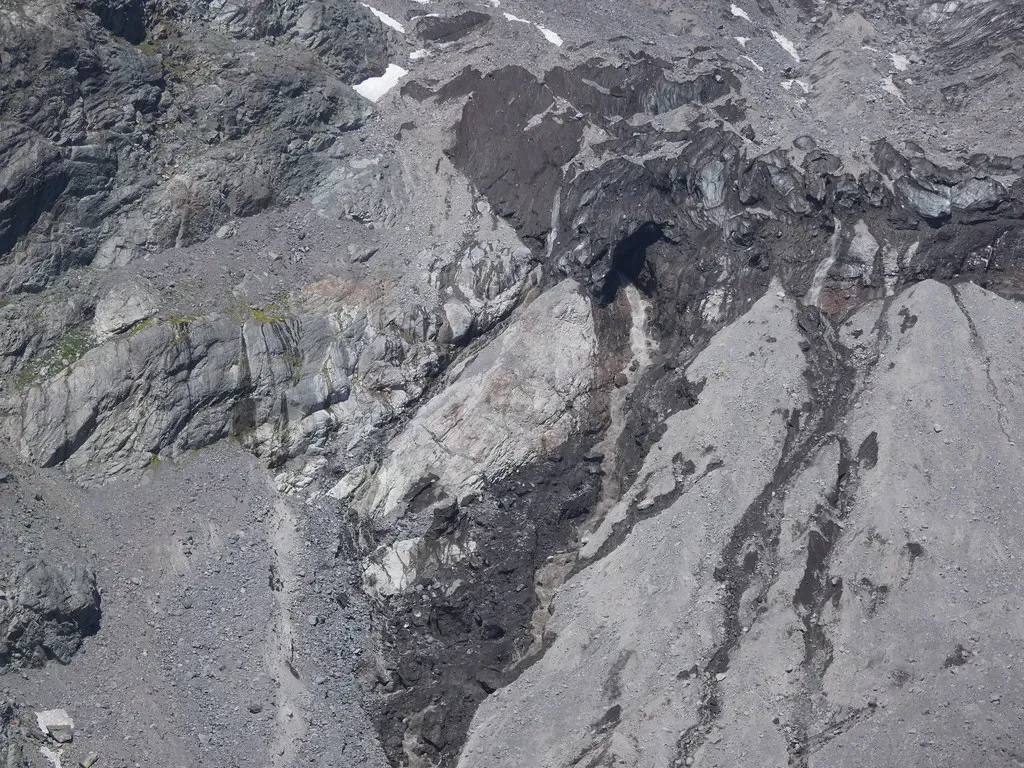
The Science of Ice Dams: How Earth’s Own Architecture Triggered Disaster
Glacial Lake Missoula formed in western Montana when a lobe of the Cordilleran ice sheet dammed the Clark Fork valley in the Idaho panhandle and meltwater built up behind the dam. Eventually the water got so deep that the ice dam began to float, resulting in a glacial outburst flood. After enough water had been released, the ice dam resettled and the lake refilled. This process is thought to have been repeated dozens of times over a period of several thousand years. It’s one of geology’s most astonishing slow-motion horror stories – a cycle of catastrophe, reset, and catastrophe again.
What’s even more mind-bending is what the weight of all that ice was doing to the land itself. The Cordilleran ice sheet was so heavy that it actually deformed the Earth’s crust in the region, changing the elevation of the surrounding topography by hundreds of meters as the ice sheet went through cycles of melting and reforming. The research team found that in order to cause the pattern and location of erosion seen in the landscape today, this massive crustal deformation played an important role in determining the exact path that the floodwaters followed. Think of the planet’s crust like a mattress being pressed down by a tremendous weight, and you start to understand how dynamic – and frankly terrifying – these events really were.
The Lake Bonneville Flood and the Birth of the Great Salt Lake
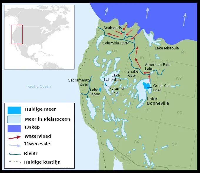
Lake Bonneville was the largest Pleistocene lake in western North America and the predecessor to the Great Salt Lake in the eastern Great Basin. During Pleistocene glaciation, the lake basin filled, covering more than 50,000 square kilometers with over 10,000 cubic kilometers of water before reaching its maximum possible stage governed by Red Rock Pass. Honestly, the scale of prehistoric lakes like this one is almost too large to picture. The modern Great Salt Lake is basically a tiny shadow of its former self, a puddle where a sea once stood.
Starting in eastern Idaho, the prehistoric Bonneville Flood carved the current route of the Snake River, created Shoshone Falls, dropped gigantic boulders all along its route, and etched permanent changes in the Idaho landscape before making it out to sea. The Lake Bonneville Flood left behind many scabland features such as dry waterfalls, alcoves, scoured bedrock surfaces, and boulder bar accumulations. Every time you drive through southern Idaho today and see those dramatic basalt canyons, you’re looking at the permanent signature of a single catastrophic draining event that happened roughly 18,000 years ago.
The Black Sea Flood and Its Connection to Ancient Human Memory
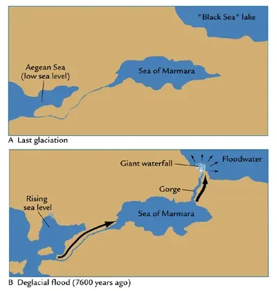
Here’s where the story gets deeply personal for all of us. The Early Holocene Black Sea flood scenario describes events that would have profoundly affected prehistoric settlement in Eastern Europe and adjacent parts of Asia, and possibly was the basis of oral history concerning the myth of Noah’s flood. Some archaeologists support this theory as an explanation for the lack of Neolithic sites in northern Turkey. You read that correctly – the geological record may actually help explain one of humanity’s most enduring and universal stories.
Water from melting ice sheets to the north flowed into the Black Sea, which was isolated from the Mediterranean by a land ridge across the Bosporus. Continued melting of the world’s ice sheets raised the level of the Mediterranean until it eventually topped the Bosporus, gushing catastrophically into the Black Sea and rapidly turning it into a salty sea. According to the hypothesis, coastal farms were flooded, and early Neolithic foragers and farmers were forced to evacuate, moving into the interior of Europe and carrying with them agriculture as well as the memory of the deluge. It’s hard not to feel something profound reading that – the idea that real geological trauma lived on for thousands of years in the stories people told their children.
Mega-Floods Beyond Earth: The Stunning Connection to Mars
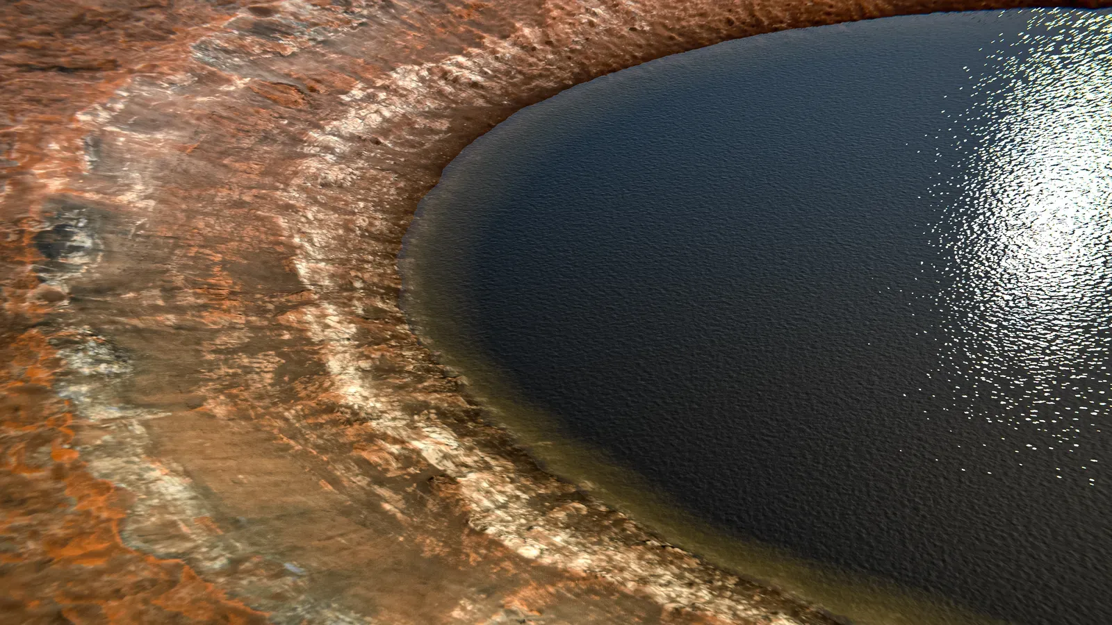
You might be thinking that mega-floods are an exclusively Earth thing. They’re not. Floods of unimaginable magnitude once washed through Gale Crater on Mars’ equator around 4 billion years ago, a finding that hints at the possibility that life may have existed there, according to data collected by NASA’s Curiosity rover. Let that land for a second. The same geological forces that carved the Channeled Scablands in Washington State also appear to have torn across the surface of another planet entirely.
The raging megaflood on Mars was likely touched off by the heat of a meteoritic impact, which unleashed ice stored on the Martian surface, and set up gigantic ripples that are tell-tale geologic structures familiar to scientists on Earth. Research published in the journal Nature Scientific Reports suggests that gigantic megafloods could have carved out the Red Planet’s surface features and even altered its climate, vastly changing our understanding of Mars’ past. I think this is one of the most exciting connections in all of science – the same catastrophic water physics that sculpted our own backyard also helped shape another world entirely. It tells you that mega-floods aren’t a quirk of Earth. They may be a universal geological force.
Conclusion
There’s something genuinely humbling about standing on ground that was once the floor of a raging prehistoric torrent. The landscape around you – those canyon walls, those dry riverbeds, those boulders sitting alone in the middle of nowhere – all of it carries a story written not in words but in rock, sediment, and the sheer force of unimaginable water. Floods on a massive scale happened not once, but hundreds of times over the course of the last Ice Age, a period of glaciation lasting roughly 2.6 million years. Each of those events left a permanent mark on the face of the planet.
What’s striking is that these mega-floods didn’t just shape geography. They may have shaped culture, mythology, and human memory itself. They may have even reached beyond our planet. The more geologists dig into the evidence, the more they find that catastrophe, not only quiet gradual erosion, has been one of the great architects of the world we inhabit. The research also points to how truly dynamic the landscape once was. So next time you cross a valley, stand at a canyon rim, or look out across a wide flat plain, ask yourself: what kind of water once moved through here – and just how much of what you see was built by disaster? What would you have guessed before reading this?