When you hear the word “badlands,” what comes to mind? Maybe a desolate wasteland or some forgotten corner of the earth. Let’s be real, the name doesn’t exactly scream “vacation destination,” does it? Yet hidden in the Dakotas lies one of the most extraordinary geological displays you’ll ever witness. These formations didn’t just appear overnight. They’re the result of ancient seas, volcanic eruptions from hundreds of miles away, and millions of years of relentless erosion carving through soft rock like a sculptor working with clay.
The Dakota Badlands span both North and South Dakota, each offering its own distinct personality. Covering over 244,000 acres of stunning badlands in South Dakota’s national park, the landscape is renowned for its striking geology, which provides a window into the region’s ancient past. What makes these landscapes so compelling is how vulnerable they are. The formations erode at about one inch a year, meaning you’re literally watching geological history disappear before your eyes. So what exactly makes these badlands so remarkable? Let’s dive into six geological marvels that time and erosion have sculpted into something truly unforgettable.
The Pierre Shale Foundation: Ancient Sea Floor Turned Solid Ground
The Pierre Shale formed around 75 million years ago when the Badlands was nothing but a shallow inland sea, existing during the same time as the Dinosaurs. This dark, muddy layer serves as the basement of the entire badlands system. Think of it as the canvas upon which everything else was painted. The Pierre Shale is composed of fine-grained clay and silt that was deposited in the Western Interior Seaway, and it contains numerous fossils of marine organisms, such as ammonites, clams, and fish.
When that ancient sea finally receded, something remarkable happened. As the water level dropped and the sea floor became land, the Pierre Shale crumbled into soil and created the Yellow Mounds Formation, so called because of its mustard-like color. You can still see these mustard-hued hills today, stark reminders that this rugged landscape was once beneath warm, shallow water teeming with prehistoric marine life.
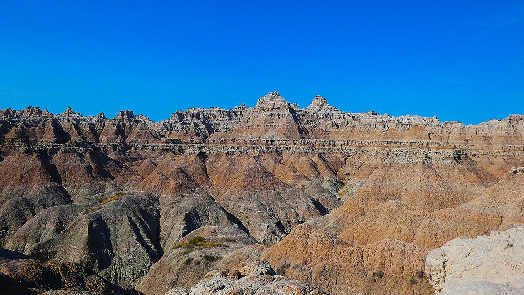
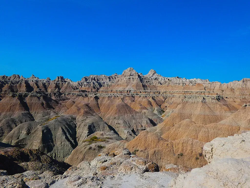
Layered Rock Formations: A Geological Timeline Written in Stone
Over the course of millions of years, the layered rocks of the Badlands were slowly stacked on top of each other like a layer cake, deposited by natural forces which range from shallow inland seas to rivers to wind. Each band of color you see tells a different story. The geology comprises a colorful layer-cake of various sedimentary rocks deposited between 28 to 75 million years ago by shallow seas, rivers, and wind, with distinct rock layers consisting of multi-colored sandstone, siltstone, mudstone, claystone, limestone, shale, and volcanic ash.
Walking through these formations is like flipping through the pages of Earth’s autobiography. These rock formations are characterized by their distinct layers, or strata, which reveal information about the changing environments and climates that existed in the region during different geologic time periods. The bands shift from dark marine deposits to lighter river sediments, then to volcanic ash layers that traveled hundreds of miles on ancient winds. It’s honestly mind-boggling when you think about the timescales involved.
Volcanic Ash Deposits: The Sharps Formation and Its Fiery Origins
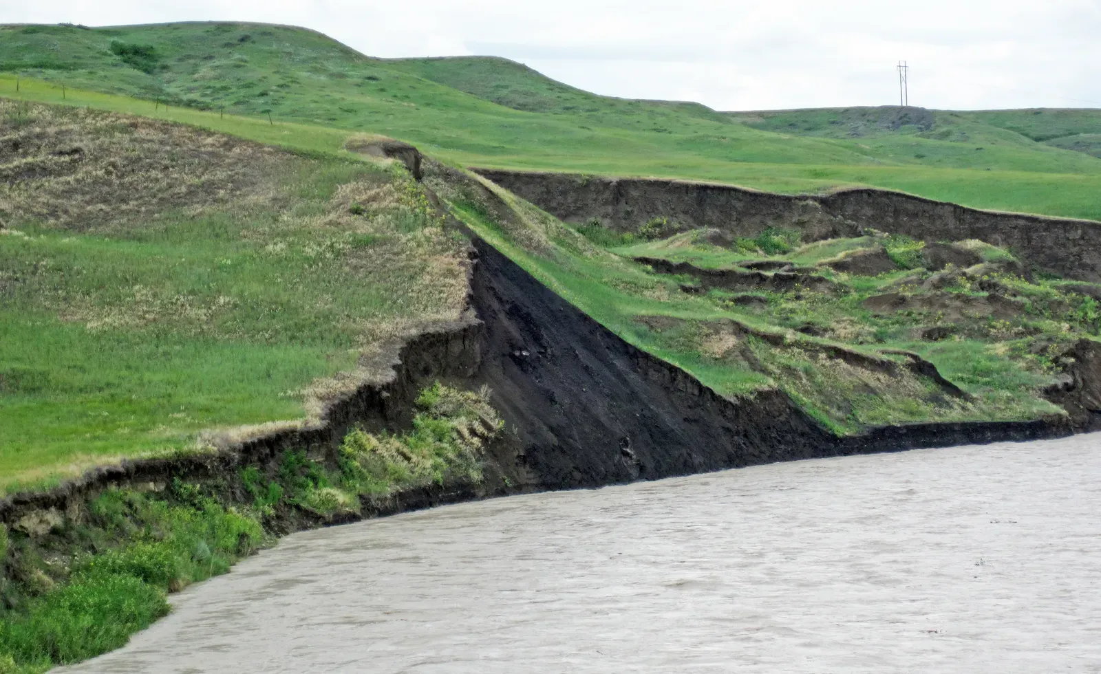
Here’s where things get really interesting. The volcanic ash originated from volcanoes located over 500 miles away in present day Nevada and Utah, blown eastward before settling in the park area, and over time, this deposited ash hardened into beige-colored volcanic tuff through the process of lithification. Imagine massive eruptions in the Great Basin sending plumes of ash so high into the atmosphere that winds carried them clear across multiple states. The base of the Sharps Formation is the Rockyford Ash, a volcanic tuff formed from ash that came from eruptions in the Great Basin, where Utah and Nevada are today.
This ash didn’t just fall and vanish. The ash was washed into the area along with eroded sediment from the Black Hills, making many of the rock layers an ash-sediment mixture, which often consists of 50% ash and 50% eroded sediment. The Sharps Formation represents the youngest geological layer in Badlands National Park, roughly 28 to 30 million years old, and it caps the entire sequence like frosting on that geological layer cake we mentioned earlier.
The Power of Water Erosion: Carving Canyons and Spires
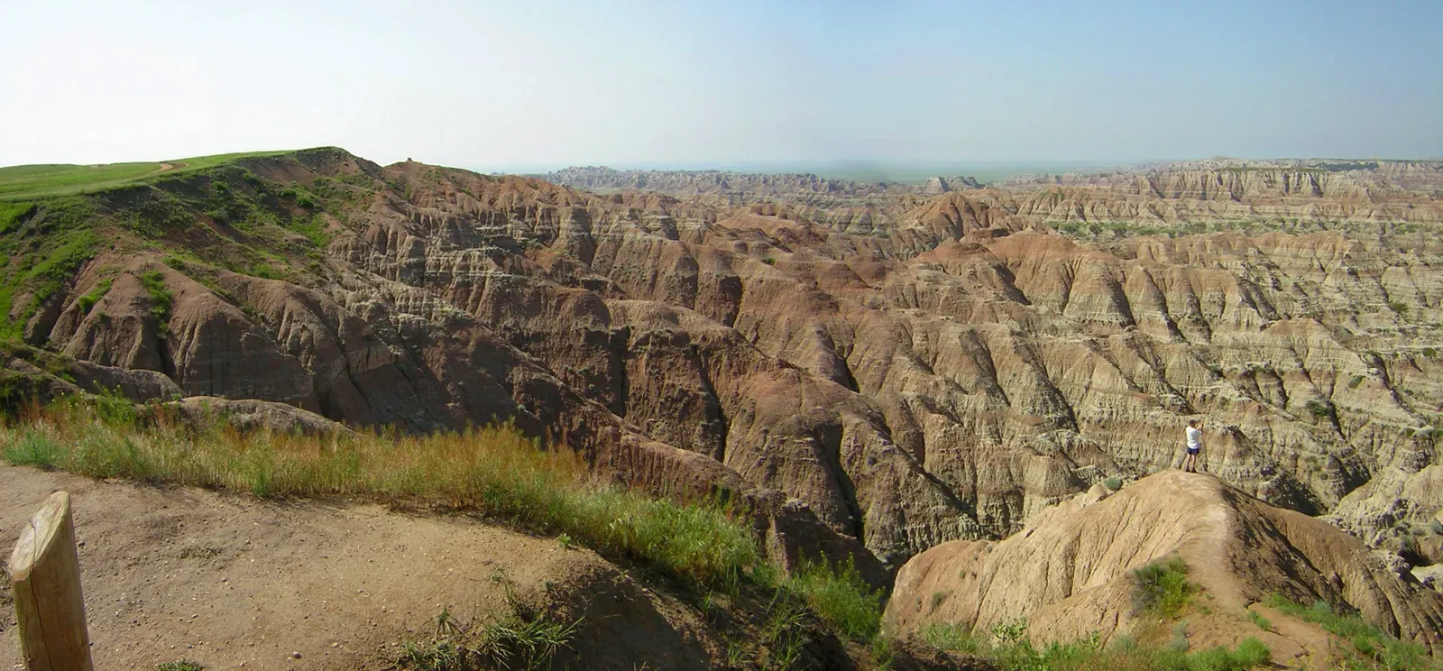
The serrated Badlands terrain did not exist until about 500,000 years ago when water began to cut down through the rock layers, carving fantastic shapes into what had been a flat flood-plain, exposing ancient fossil soils buried for millions of years. Water is the true sculptor here, the master artist behind every canyon, gully, and towering spire. Water is a major agent of erosion in the Badlands, as the park experiences periodic heavy rainfall events which result in erosion of the soft sedimentary rocks, washing away loose sediments and exposing underlying rock layers.
What’s fascinating is how quickly this happens. It has been estimated that the badlands of Badlands National Park erode at the relatively high rate of about one inch or 25 millimetres per year. Compare that to harder rocks like granite, and you’ll appreciate just how temporary these formations are. The Badlands erode at the rate of one inch per year, which is a rapid rate for rocks, in contrast with the granite of the Black Hills eroding at the rate of one inch per 10,000 years. Every rainstorm reshapes the landscape just a little more.
Theodore Roosevelt’s North Dakota Badlands: Glacial Influence and River Downcutting
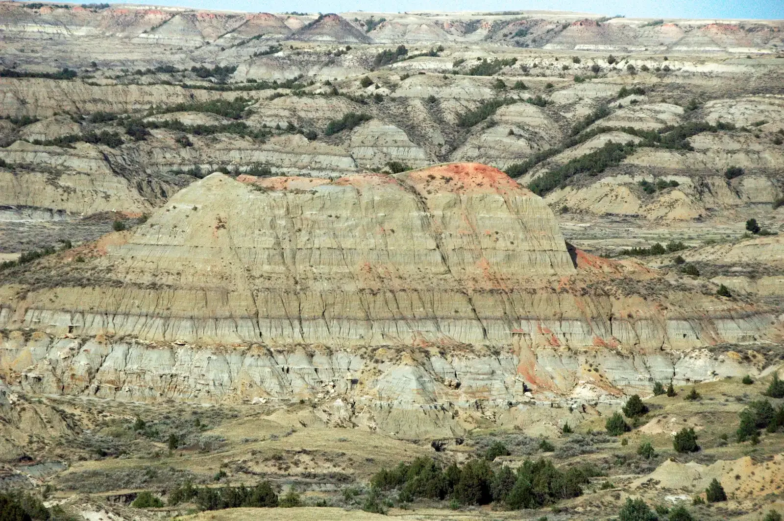
The North Dakota badlands have their own unique origin story. After the glacier diverted the Little Missouri River eastward, it flowed over a shorter, steeper route than before, initiating badlands development as a vigorous cycle of erosion and downcutting began, making the badlands ultimately a product of glacier processes. Without that glacial intervention, these dramatic landscapes might never have existed. The sedimentary layers exposed are mainly continental sediments deposited by rivers and streams flowing east to the Dakotas from the Rocky Mountains at the time of the Laramide orogeny, consisting of layers of poorly lithified siltstone, claystone, sandstone, and lignite coal.
Theodore Roosevelt himself fell in love with this rugged terrain. The badlands of Theodore Roosevelt National Park formed mainly through erosion by the Little Missouri River, attracting geological interest because of well-exposed rock formations, with two primary formations being the Bullion Creek Formation and the overlying Sentinel Butte Formation. Near the river’s headwaters in northeastern Wyoming, the river has cut down about 25 meters below its previous level, while near Medora, the valley floor is 80 meters lower than the pre-diversion level. That’s an astonishing amount of material carried away by water over time.
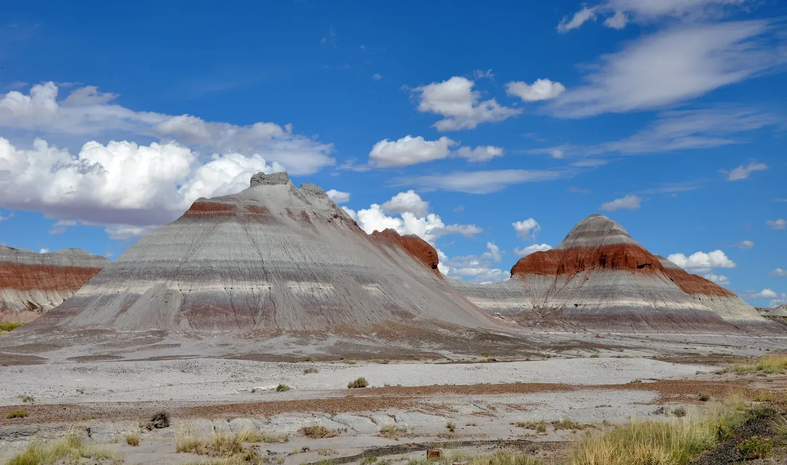
Bentonite Clay and Hoodoos: The Weird Shapes That Defy Gravity
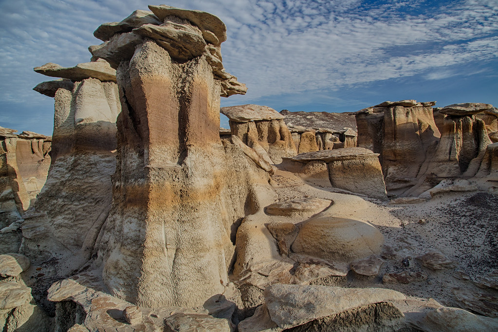
Walk through the badlands and you’ll encounter some truly bizarre formations. The Little Missouri River cut through sediments exposing about 620 feet of the Tongue River formation creating typical badlands topography, with sandstone concretions capping weird shapes in the bentonite clay now called “hoodoos”. These hoodoos look like they shouldn’t exist, like something out of a fantasy landscape. Lightning strikes and prairie fires can ignite coal beds which burn for many years, baking overlying sediments into a hard natural brick called porcelanite but locally called “scoria,” with the red color coming from the oxidation of iron released from the coal as it burns.
These hardened rocks are more resistant to erosion than the unbaked rocks nearby, so erosion has worn down the less resistant rocks, leaving behind a jumble of knobs, ridges, and buttes topped with durable red scoria caps. The bentonite clay itself has fascinating properties. Bentonite is composed principally of the clay mineral montmorillonite, which can swell conspicuously when wet, and the bentonites in the badlands can absorb up to several times their weight in water and are extremely slick and mobile when wet. This creates the perfect conditions for those fantastical shapes that make the badlands so photogenic and otherworldly.
Conclusion
The Dakota Badlands represent something special in our natural world. They’re not permanent monuments like mountains or ancient forests. Instead, they’re transient masterpieces, constantly changing, constantly eroding, reminding us that even the earth beneath our feet is temporary. Scientists estimate that in the next 500,000 years, the Badlands will have eroded completely.
These six geological marvels show us the power of time, the influence of ancient seas, distant volcanic eruptions, and the relentless work of water and wind. From the ancient Pierre Shale sea floor to the colorful layered formations, from volcanic ash blown hundreds of miles to the dramatic canyons carved by rivers, from glacier-influenced erosion to the strange hoodoos capped with red scoria, each feature tells part of a much larger story.
So what will you take away from this journey through geological time? Will you visit these landscapes while they still exist, walking among formations that won’t be here forever? The Dakota Badlands aren’t just rocks and dirt. They’re a reminder that our planet is alive, constantly reshaping itself, and that we’re privileged to witness this particular moment in its endless transformation.