When you think about dinosaurs roaming North America, you might picture them on landscapes pretty similar to what exists today. That couldn’t be further from reality. The ground beneath their feet was constantly shifting, literally rearranging the entire continent over millions of years. Honestly, I think it’s one of the most underappreciated chapters in the dinosaur story.
The continents you see around you today weren’t always separate. During the roughly 165 million years dinosaurs existed, this supercontinent slowly broke apart, with its pieces spreading across the globe through plate tectonics. The forces that cracked continents in half and thrust mountains skyward didn’t just change the scenery. They fundamentally rewrote where dinosaurs could live, what they could eat, and even which species survived.
Let’s be real, understanding how moving tectonic plates created mountains, inland seas, and isolated habitats makes you rethink everything about these ancient creatures. So let’s dive in.
When Pangaea Fractured: Setting the Stage for Dinosaur Diversity
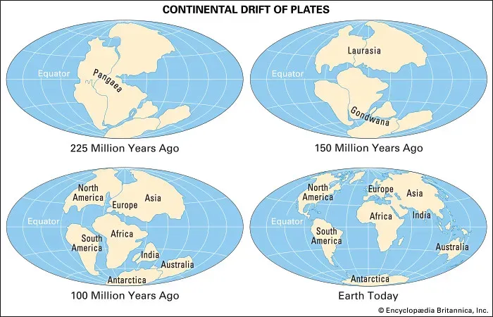
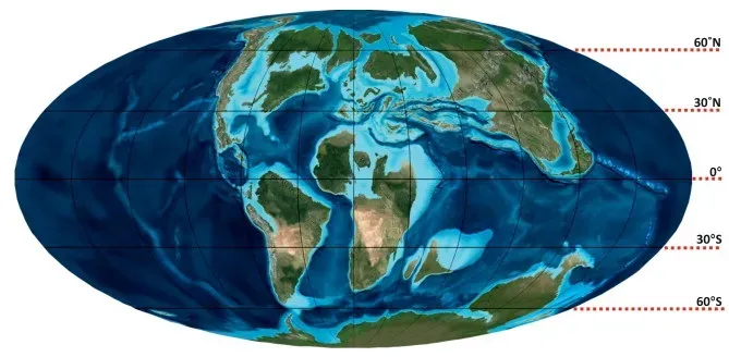
At the beginning of the age of dinosaurs during the Triassic Period, roughly 230 million years ago, the continents were arranged together as a single supercontinent called Pangea. Picture that for a moment – every landmass connected. Dinosaurs from what would become Africa could theoretically walk to future North America without crossing an ocean.
During the Triassic Period, dinosaur distribution was uniform due to the single continental landmass, with early species like coelophysoid carnivores and basal sauropodomorphs able to spread widely. There was no Atlantic Ocean yet, no vast seaways cutting through the middle of continents. Heat from Earth’s mantle began to fracture this massive crustal plate over tens of millions of years, causing the landmasses to rift and pull apart, with widening fissures filling with water and forming new oceans.
This wasn’t a sudden event, though. The breakup played out over countless generations of dinosaurs. This geographical evolution created new coastlines, altered global climate patterns, and isolated dinosaur populations on different landmasses, acting as a catalyst for evolution as each separated group began to develop unique physical traits. That isolation meant groups of dinosaurs that were once neighbors gradually became strangers evolving in completely different directions.
North America Drifts Northward: Climate Shifts and Habitat Transformations
Here’s something you might not expect. Approximately 200 million years ago during the late Mesozoic Era, North America was part of Pangaea situated near the equator, but as tectonic plates moved, North America gradually shifted northward away from the equatorial region. That movement wasn’t trivial.
This shift had various effects on the continent’s climate and ecology, as regions that were once warm and tropical became cooler over geological time. The fossil record shows tropical plants once thrived in areas that are now much colder. Think about that – dinosaurs in regions of modern-day Canada or Montana were experiencing very different climates than we associate with those places now. Warmer, wetter, sometimes outright tropical environments supported lush plant life, which in turn supported massive herbivorous dinosaurs and their predators.
The northward drift meant dinosaur habitats transformed continuously. Forests changed composition. By the end of the Cretaceous, oaks, hickories, and magnolias became common in North America. Seasons became more pronounced. All of this happened because the ground itself was migrating across latitudes, driven by relentless tectonic forces beneath.
The Western Interior Seaway: A Tectonic Gift That Split a Continent
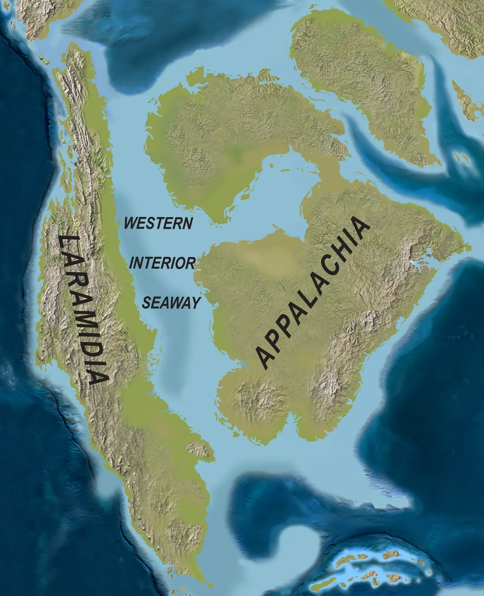
One of the most dramatic consequences of tectonic activity was the creation of an inland sea that literally split North America in two. The Western Interior Seaway was a large inland sea that existed roughly over the present-day Great Plains, splitting the continent into two landmasses, Laramidia to the west and Appalachia to the east, for 34 million years from the early Late Cretaceous to the earliest Paleocene. Imagine an ocean running right through the middle of the continent, from the Arctic to the Gulf of Mexico.
During the Cretaceous period, the ancient Farallon and Kula tectonic plates were subducting beneath the North American Plate, causing the overlying land to warp and form a large back-arc basin that ocean waters began to fill during sea level increases, producing the Western Interior Seaway. This wasn’t just some shallow puddle, either. At its largest extent, the seaway was 2,500 feet deep, 600 miles wide and over 2,000 miles long.
For dinosaurs, this changed everything. The southern embayment merged with the Mowry Sea in the late Cretaceous, forming a completed seaway that created isolated environments for land animals and plants, with relative sea levels falling multiple times and temporarily rejoining separated populations before separating them again. The dinosaur populations on either side evolved independently, leading to distinct species you wouldn’t find on the opposite shore.
Mountain Building and the Birth of the Rockies: Dinosaur Diversity Explodes
The story gets even more interesting when mountains enter the picture. During the early to middle Cretaceous, geological forces lifted the western United States, creating a huge mountain range called the Sevier Mountains that extended from the American southwest through Alberta, with the area just to the east flexing downward and creating the shallow Western Interior Seaway that flooded the continent, cutting it into three large islands densely populated with dinosaurs.
What’s remarkable is how this geography influenced speciation rates. New species of duck-billed and horned dinosaurs were being born at an explosive rate of every few hundred thousand years during the brief time when the two mountain ranges and the seaway coexisted, as isolated populations often evolve new features more rapidly. That’s incredibly fast in evolutionary terms.
The rise of the Sevier Mountains and the growing seaway caused dinosaur habitat to shrink on Laramidia, and geographic as well as ecological barriers created by the rise of mountain ranges and the seaway caused isolation of northern and southern populations of crested duck-billed and horned plant-eating dinosaurs. The mountains weren’t just scenic backdrops. They were active barriers forcing dinosaur populations into smaller, isolated pockets where rapid evolution could occur.
Laramide Orogeny: The Final Act of Mountain Building
The Laramide orogeny was a time period of mountain building in western North America that started in the Late Cretaceous, 80 to 70 million years ago, and ended 55 to 35 million years ago, occurring in a series of pulses with quiescent phases intervening. This wasn’t the same as the earlier Sevier mountain building – it was a distinct phase with its own character.
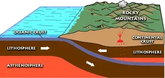
The Farallon plate began to subduct at an unusually shallow angle, sliding farther inland beneath western North America before finally sinking into the asthenosphere, which downwarped the center of the continent and created a basin that allowed waters of the Gulf of Mexico to meet with northern waters. That shallow subduction angle was critical. It meant tectonic forces were felt hundreds of miles inland, not just at the coast.
According to paleontologist Thomas M. Lehman, the Laramide orogeny triggered the most dramatic event that affected Late Cretaceous dinosaur communities in North America prior to their extinction, with this turnover event seeing the replacement of specialized and highly ornamented centrosaurine and lambeosaurines by more basal upland dinosaurs in the south. The changing topography literally rewrote which dinosaur types could thrive where. Upland dinosaurs moved in as the landscape rose and environments shifted.
Isolated Islands, Unique Dinosaurs: Evolution in Action
When the Western Interior Seaway was at its peak, North America wasn’t one landmass – it was effectively several islands. In Late Cretaceous North America, the Western Interior Seaway bisected the continent from north to south, isolating eastern and western regions from each other, and these two regions developed distinct faunal assemblages during this time. What you found on Laramidia looked very different from Appalachia.
The same species of at least some duck-billed dinosaurs lived from Canada through southern Utah at some points in the Cretaceous, yet during times of isolation these giant plant-eaters roamed a much smaller area than you might think given that many were larger than elephants. Isolation did more than just keep populations separate. It accelerated change.
Climatic changes periodically occurring as a result of orogenic uplift and basin segregation may have occurred sufficiently fast enough to outpace plants from crossing barriers, altering ecosystems substantially enough to create isolated biomes, supported by documented palynomorph evidence indicating isolated pollen provinces in Late Cretaceous sediments. Different plant communities meant different food sources. Different food sources meant specialized herbivores. And specialized herbivores supported distinct predator populations.
The Seaway’s Retreat and Reconnection: Bringing Populations Back Together
Eventually, what plate tectonics created, it also undid. The seaway closed off at the end of the Cretaceous and gradually disappeared due to regional uplift and mountain-building on the western side of North America. Around 70 million years ago during the very latest stages of the Cretaceous period, the Western Interior Seaway was displaced by slow uplift of the continent.
As the Rockies continued to rise and the shallow sea drained away, something fascinating happened. Eventually, the continued rise of the Rocky Mountains kept the sea away from the continent’s interior, opening up a vast territory for these dinosaurs to roam, which in turn reduced how fast new species evolved in the region to every few million years. More space meant less isolation. Less isolation meant slower speciation.
The reconnection of eastern and western North America allowed previously isolated dinosaur populations to mix again. Some species expanded their ranges dramatically. Others, already highly specialized for their isolated environments, may have struggled when facing new competition. By the time the asteroid struck 66 million years ago, the landscape dinosaurs inhabited looked profoundly different than it had just 20 million years earlier – all thanks to tectonic forces reshaping their world.
Conclusion: Plate Tectonics as the Invisible Architect
The tectonic forces that shaped North America during the Mesozoic Era were nothing short of transformative. They split continents, raised mountain ranges, flooded vast inland seas, and isolated populations long enough for evolution to work its magic. Without understanding plate tectonics, the dinosaur fossil record would seem random – scattered species appearing and disappearing without clear reasons.
But when you see how the ground itself was moving, fragmenting, uplifting, and reconnecting, everything clicks into place. Mountains created barriers. Seas created islands. Isolation created new species. Reconnection created competition. The dinosaurs weren’t just living on North America. They were living on a dynamic, ever-shifting stage that determined who survived and who vanished long before the final curtain fell.
What do you think about the idea that geology, not just biology, drove so much of dinosaur evolution? It makes you wonder what our world will look like millions of years from now.