You live on a planet that has been breaking itself apart, colliding, drowning in oceans, and erupting in lava for billions of years – and you can actually see the scars. All across the United States, ordinary-looking cliffs, canyons, and road cuts quietly hold records of vanished seas, supervolcanoes, and floods that made modern disasters look tiny. When you start to read the rocks, even a simple viewpoint pullout suddenly feels like a time machine. In this article, you’re going to travel from billion‑year‑old continental crust in the Midwest to an active supervolcano in the Rockies and the deepest caves of Kentucky. You’ll see where ancient reefs grew in warm tropical seas, where cataclysmic ice‑age floods tore across a whole state, and where a staircase of national parks lets you literally walk down through hundreds of millions of years of time. You will not hit every famous spot in the country, but you will come away with a clearer sense of just how old, strange, and alive Earth’s story really is – and how easy it is to stand right in the middle of it without realizing what you’re looking at. —
1. Grand Canyon, Arizona – A Nearly Two-Billion-Year-Long Rock Record
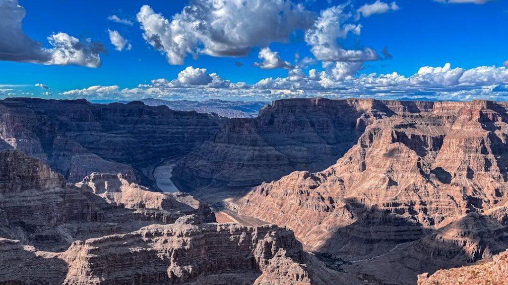
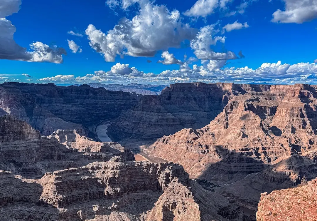
When you stand on the rim of the Grand Canyon and look down, you’re staring into a cross‑section of almost two billion years of Earth’s history laid bare. Near the top, you see younger, flat‑lying sedimentary rocks that formed on ancient seas, coastal plains, and deserts; down near the river, you see much older, dark metamorphic rocks that were buried, cooked, and deformed long before dinosaurs ever existed. Geologists sometimes call this canyon one of the best windows into geologic time on Earth because so many different rock layers and environments are stacked in a single, breathtaking cut. You can literally trace how the environment shifted from shallow marine to coastal dunes to rivers and back again as continents drifted and sea levels rose and fell. As you follow the Colorado River’s path in your mind, you’re also tracing a long process of uplift and erosion rather than one single carving event. The Colorado Plateau, where the canyon sits, was lifted thousands of feet, giving the river extra gravitational “oomph” to slice down through the rock over millions of years. Along the way, side canyons, landslides, and rockfalls widened and complicated the canyon into the maze you see now. If you hike down even partway, every switchback is like turning a page in a rock history book, with fossils, cross‑beds, and unconformities quietly marking chapters in an unimaginably long story. Did you expect one overlook to hold such a massive slice of Earth’s timeline?
—
2. Yellowstone, Wyoming – A Living Supervolcano and Boiling Planetary Plumbing

Yellowstone might feel like a national park built for postcards – colorful hot springs, bison in meadows, eruptions of Old Faithful – but what you’re really walking around is the collapsed roof of an enormous ancient volcano. The park sits inside a gigantic caldera left behind by some of the largest known eruptions on the planet, with the youngest of these calderas stretching roughly tens of miles across. Magma still lurks just a few miles beneath your feet, and the heat from this body of molten rock drives the geysers, hot springs, mud pots, and steam vents that make Yellowstone feel like a planet in the middle of a science experiment. When you see terraces of white and orange mineral deposits or rainbow‑rimmed pools, you’re looking at hot water bringing dissolved minerals up from deep below and then dropping them at the surface. Over time, the hotspot that powers Yellowstone has migrated relative to the moving North American plate, leaving a trail of ancient volcanic scars stretching to the southwest. You can think of the plate as a conveyor belt slowly sliding over a stationary blowtorch; every so often, the blowtorch punches through and leaves a caldera and lava flows behind. The fact that you can drive smoothly across this landscape shows you how good Earth is at healing its wounds, even after cataclysms on a truly continental scale. As you walk the boardwalks around a boiling spring, you’re seeing a rare chance to watch the deep, hot interior of the planet leak through its own crust in real time.
—
3. Bryce Canyon, Utah – Otherworldly Hoodoos from an Ancient Lake Bed

When you first look out over Bryce Canyon, it barely looks real: a forest of pink, orange, and cream‑colored rock spires, called hoodoos, clustered into amphitheaters that seem almost sculpted by hand. Those hoodoos are carved from the Claron Formation, a stack of fine‑grained sedimentary rocks that record a series of ancient lake and floodplain environments. Long before these rocks became a high‑elevation plateau, sediments quietly settled in basins, layer after layer, as water depth, climate, and chemistry changed. Over millions of years, those soft sediments hardened into limestone, mudstone, and siltstone, preserving subtle banding and colors that now light up at sunrise and sunset. The wild shapes you see today are a kind of slow‑motion magic show produced by frost, rain, and gravity. Water seeps into cracks, freezes and expands, prying blocks apart; slightly acidic rain dissolves some minerals more easily than others; and over time the combination produces walls, windows, and free‑standing pillars. What really blows your mind is that Bryce is part of a much larger “Grand Staircase” of rock layers that step down through time toward Zion and the Grand Canyon. That means the story recorded in Bryce’s cliffs is just one chapter in a much longer regional saga – and when you move from one park to another, you’re essentially flipping up and down through pages of the same giant geologic book.
—
4. Zion and the Grand Staircase – Walking Down Through Deep Time
If you drive from Bryce Canyon to Zion and then to the Grand Canyon, you might feel like you’re simply touring three different parks. In reality, you’re walking down a massive rock staircase that geologists call the Grand Staircase, where layers that form the top of one park show up lower down in the next. At Bryce, you mainly see the younger, pastel lake sediments of the Claron Formation. At Zion, you’re staring up at towering cliffs of Navajo Sandstone, the remains of giant ancient desert dunes that migrated across the region when the climate and position of the continent were very different. As you continue down toward the Grand Canyon, you expose older and older formations that once sat beneath those dunes. What makes this trio so powerful for understanding Earth’s past is how clearly it connects environments across time and space. The bottom rocks at Bryce are the top rocks at Zion, and the bottom rocks at Zion reappear as part of the uppermost Grand Canyon layers. You can almost imagine a single, enormous stack of rock being sliced by erosion, then revealed in different cross‑sections by different rivers. As you stand at a Zion overlook or look across the Grand Canyon’s layered walls, you’re really seeing the same planet in multiple moods: lake basin, sand desert, coastal plain, shallow sea, and deeply buried crust, all held in a single sweep of stone.
—
5. Yellowstone’s Deep Caves and Mammoth Cave, Kentucky – Underground Time Capsules
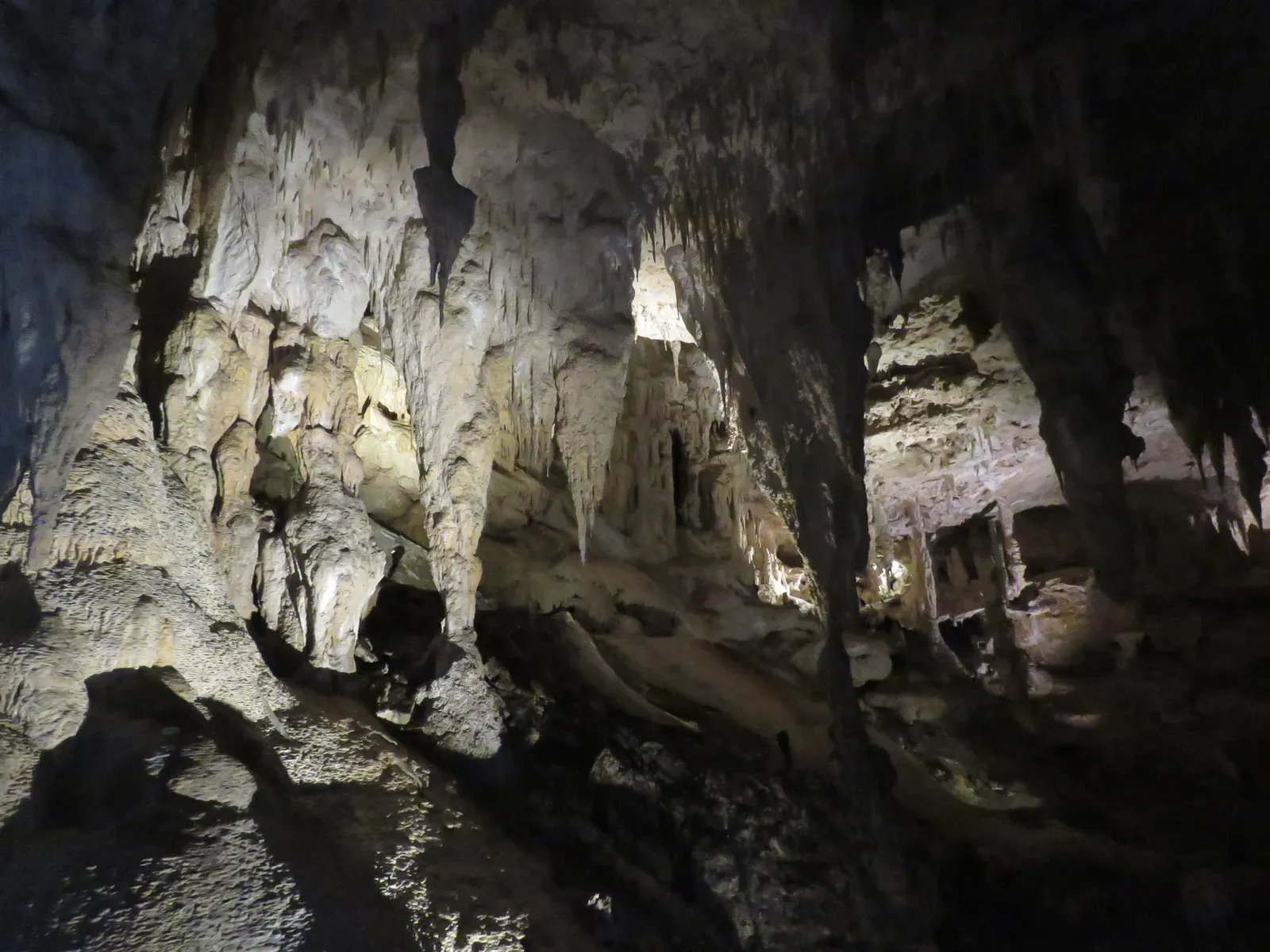
When you think about Earth’s ancient past, you probably picture mountains and canyons, not pitch‑black tunnels deep underground. Yet caves like Mammoth Cave in Kentucky hold incredibly rich records of past landscapes and climate. Mammoth Cave is the longest known cave system in the world, with more than hundreds of miles of mapped passages carved through thick layers of limestone. Those limestones once formed on the floor of warm, shallow seas filled with shells and marine life. When you walk through the cave, you’re literally walking along old seafloors and reef structures that were later lifted up, exposed to rainwater, and slowly hollowed out. Inside, the ceilings, walls, and dripstone formations quietly track changes in groundwater levels, rainfall chemistry, and even vegetation on the surface above through time. Thin mineral layers in stalagmites, for example, can act a bit like tree rings, archiving shifts in moisture and temperature. Similar processes operate in deep limestone caves in other parks, including parts of the broader Yellowstone region, where water percolating through carbonate rocks interacts with volcanic heat and gases. You may not see fossils and layers as clearly underground as you do in a canyon wall, but the rock is still telling you where oceans once spread, when land rose, and how Earth’s climate pulsed over tens of thousands of years.
—
6. Channeled Scablands, Washington – Scarred by Catastrophic Ice Age Floods
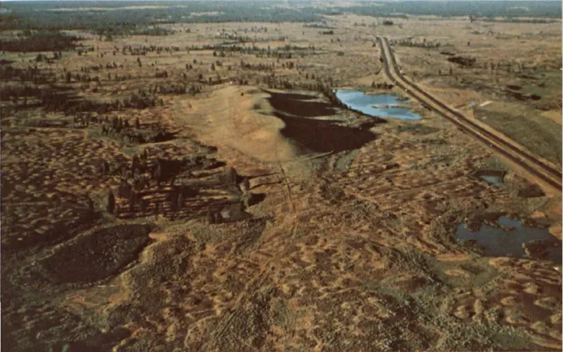
Eastern Washington’s Channeled Scablands do not look like the gentle farm country you might expect from a map of the region. Instead, huge swaths of land are scraped, grooved, and pitted, with dry canyons, isolated rock buttes, and giant gravel bars that seem wildly out of scale with the modest rivers that flow there today. For a long time, geologists argued about how such a landscape could form. The features did not fit with slow, ordinary erosion. Eventually, careful field work showed that the Scablands are the product of repeated, absolutely enormous floods that roared across the region at the end of the last ice age. When an ice dam holding back glacial Lake Missoula failed, walls of water hundreds of feet high surged across eastern Washington, stripping away soil, plucking out blocks of rock, and sculpting the “channeled” pattern you can still see from the air. If you walk along one of the dry coulees or stand near a basalt cliff cut by these floods, you are essentially standing in the trace of some of the most intense freshwater flows ever documented on Earth. The floods happened more than once, leaving layered deposits and erosional features that geologists can read like crime‑scene evidence. The story here matters for more than local scenery: it helped shift geology back toward accepting that rare, high‑energy events can shape landscapes drastically, alongside slow, everyday processes. Next time you see a modest creek meandering through this stripped‑bare country, it is a bit like watching a garden hose trickling across the empty bed of a stadium‑sized swimming pool that was violently drained long ago.
—
7. Morton Gneiss and the Ancient Crust of the Midwest, Minnesota
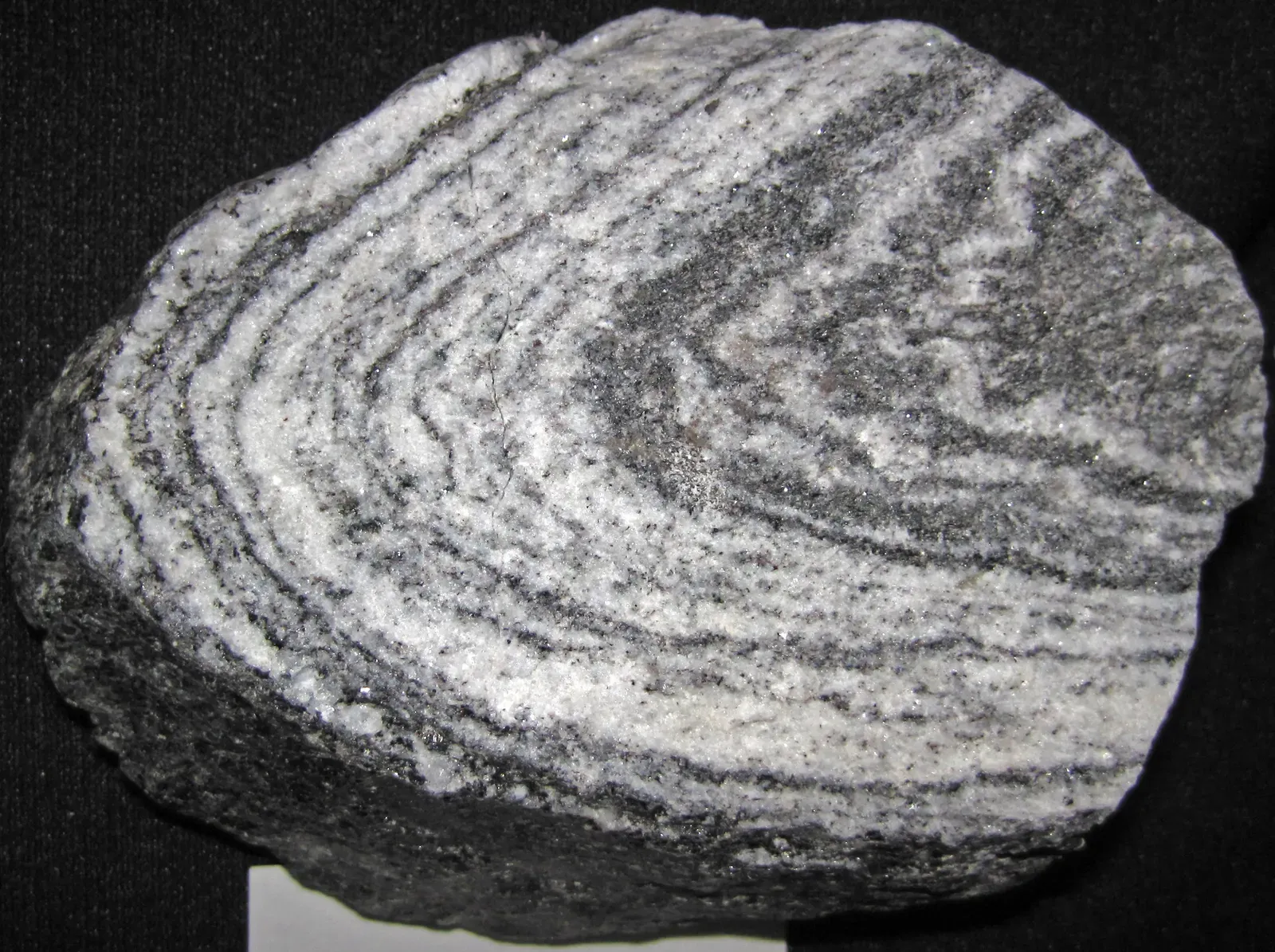
On the surface, a rock outcrop in southwestern Minnesota does not seem like a big deal. Yet some of the gneiss exposed there – often called Morton Gneiss after a local town – belongs to some of the oldest known continental crust in the United States, forming roughly three and a half billion years ago. These banded, swirling rocks have been squeezed, heated, and reworked many times, bearing witness to a young Earth that was far hotter and more tectonically active than today. When you run your hand across one of these polished outcrops, you are literally touching material that solidified when the planet’s crust was still assembling and life, if it existed at all, was microbial and primitive. Over the eons, glaciers and rivers stripped away younger covers of sediment, leaving windows into this ancient basement rock along river valleys. Geologists study the minerals and isotopes in these gneisses to reconstruct early tectonic events, like the collisions of tiny continental fragments that eventually welded together the stable heart of North America. To you, the rock might just look like beautiful decorative stone used on buildings or monuments, but its age and composition reveal a deep‑time story that dwarfs most of the other features in this list. It is like finding a surviving page from the first chapter of a book where almost every other page has been burned.
—
8. Fossil Reefs of the Ancient Seas, Wisconsin – Schoonmaker Reef
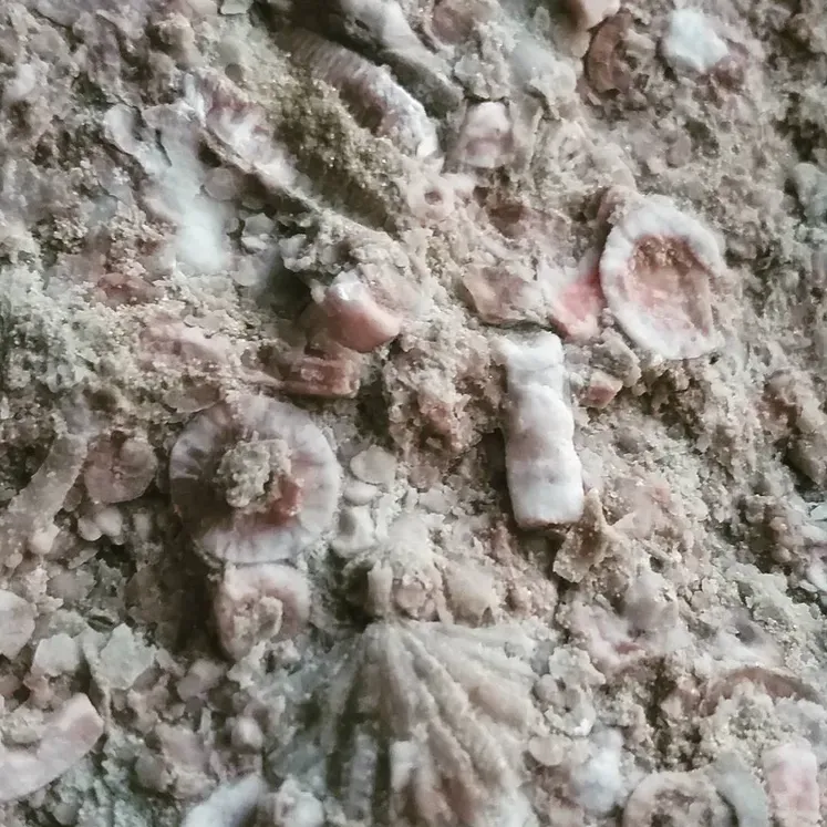
In a quiet part of Wauwatosa, Wisconsin, you can stand on what used to be a thriving coral reef – if you are willing to wind the clock back nearly four hundred and twenty‑five million years. Schoonmaker Reef is a fossilized reef complex formed in a warm, shallow sea during the Silurian Period, long before mammals, birds, or flowering plants existed. Today it appears as a rocky hill stretching several hundred feet, but close inspection reveals abundant fossilized remains of ancient marine organisms that once built this structure much the way modern coral reefs grow in tropical waters. When you picture Wisconsin, you probably think of forests and farmland, not a tropical coastline, yet the rocks insist that this place was once lapped by clear, warm ocean water teeming with invertebrate life. Geologically, this reef is important because it was one of the first ancient reefs ever described on mainland North America. By studying outcrops like this, you can learn how reef ecosystems responded to changes in sea level, climate, and chemistry as Earth cooled from earlier greenhouse intervals. You also get a reminder that continents wander and climates shift; a spot that is now far from the ocean at a cool latitude can carry rock evidence of an entirely different world. Standing on Schoonmaker Reef, you are effectively standing in the skeleton of a long‑vanished tropical ecosystem, preserved in stone instead of live coral and sand.
—
9. Lake Superior Agates and the Midcontinent Rift, Upper Midwest
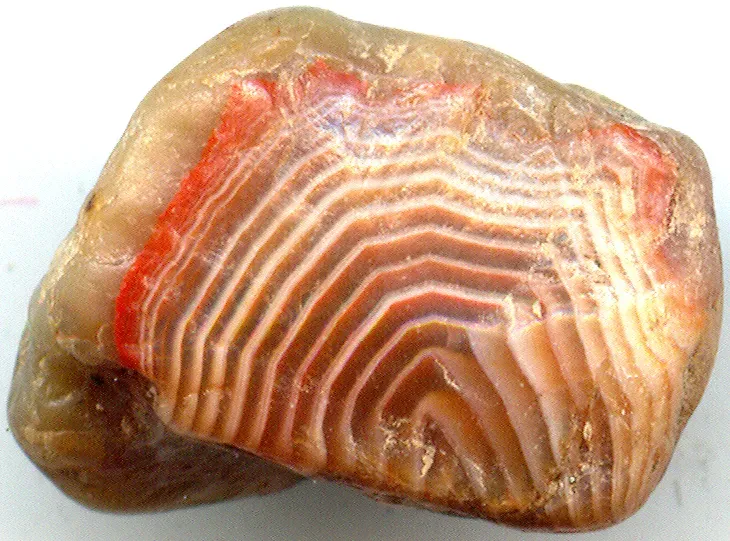
Walk along certain stretches of beach on Lake Superior, and you might spot small, banded, reddish stones that glow when wet or held to the light. These are Lake Superior agates, and they are not just pretty souvenirs; they are tiny relics of one of the most dramatic rifting events in North American history. About one point one billion years ago, the heart of the continent tried to split apart along what is now called the Midcontinent Rift, opening a long arc from the present Lake Superior region southwestward and then southeastward toward the interior of the United States. Huge volumes of basaltic lava poured out, building thick volcanic piles. Within gas bubbles in those flows, minerals precipitated and slowly formed the concentric bands you see as agate today. Later, when rifting failed and the region stabilized, erosion and repeated glaciations broke up the lava and scattered the agates into sediments across the surrounding states. When you pick up one of these stones on a modern shoreline, you are holding a polished fragment of a failed ocean in your hand – a “what if” moment in Earth history that never fully unfolded. If the rift had kept opening, the continent could have split, leaving an ocean basin where farm fields and forests now stand. Instead, you get a more subtle souvenir: small, hard jewels formed from ancient volcanic bubbles, carried by ice and water, waiting for you to notice them among the beach gravel.
—
10. Yosemite Valley, California – Granite Exposed by Uplift and Sculpted by Ice
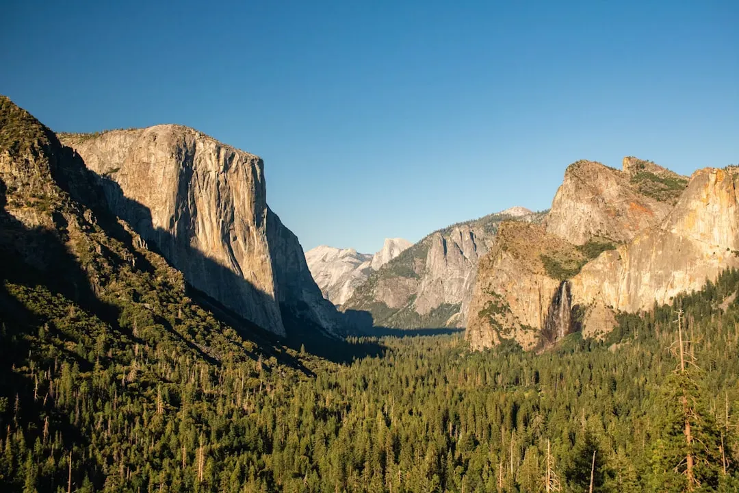
Yosemite’s sheer granite cliffs and iconic features like El Capitan and Half Dome might look timeless, but they are actually the outcome of several overlapping geologic stories. Deep underground, long before there was a valley, blobs of molten rock slowly cooled to form large granitic bodies within the crust as part of an ancient volcanic arc. Over tens of millions of years, erosion stripped away the volcanic cover and shallower rocks, eventually revealing the tougher granite at the surface. Then came uplift and, during the ice ages, glaciation: massive valley glaciers flowed down the drainages, grinding and plucking rock as they went. This process widened V‑shaped river valleys into the classic U‑shaped troughs and steep walls you see today. As you hike to a viewpoint or feel the smooth polish on certain slabs, you’re seeing the fingerprints of that ice. Striations on rock surfaces show you the direction of glacial flow, while perched boulders tell you where the ice once carried stones and dropped them as it melted. Waterfalls now plunge over cliffs that would not exist without that intense sculpting. Yosemite is a perfect place to realize that what looks like a single, unified landscape actually stitches together deep magmatic processes, long‑term erosion, tectonic uplift, and the relatively recent power of ice. In one valley, you get to see how Earth reworks its crust from the inside out and then lets weather and climate refine the details.
—
11. Badlands and Painted Deserts, South Dakota and Arizona – Colorful Fossil‑Rich Time Slices
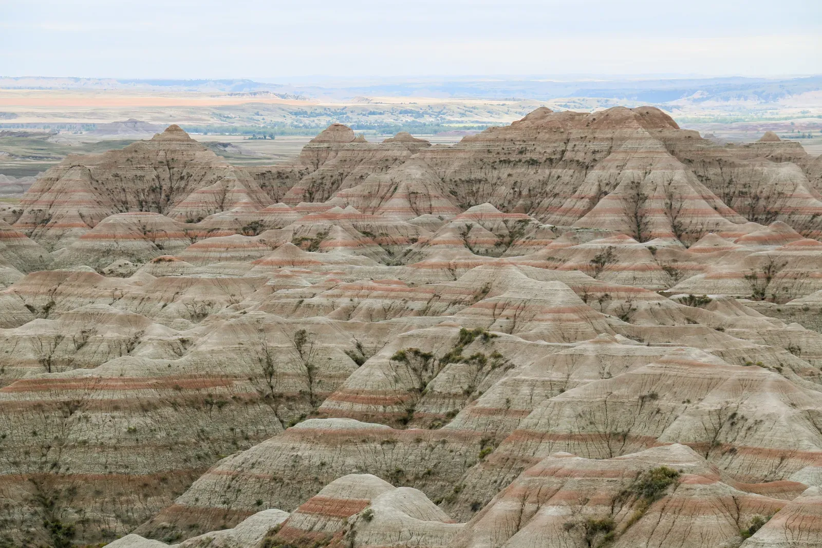
The banded buttes and eroding gullies of places like Badlands National Park in South Dakota and the painted badlands of northern Arizona are some of the most vivid outdoor museums you can walk through. Layer upon layer of mudstone, sandstone, and volcanic ash record changing floodplains, forests, and river systems over tens of millions of years. Fossils of ancient mammals, turtles, and other animals are common here, often weathering out of soft slopes where rain has washed away fine sediment. When you step onto a trail, you are placing your feet on surfaces that might not last long; the landscape is actively being reshaped by each storm, exposing fresh fossils and slowly erasing others. What makes these badlands especially powerful as windows into Earth’s past is how clearly they connect climate, ecosystems, and geologic processes. Changes in color from gray to purple to yellow mark shifts in mineral content and the conditions under which the sediments were laid down. Volcanic ash layers, sometimes preserved as pale streaks, can be dated and used as time markers, letting scientists pin down when certain animals lived or when the environment grew warmer, cooler, wetter, or drier. As you follow the curve of a ridge or look out over a maze of gullies, you are not just seeing erosion; you are seeing a slow‑motion documentary of how continents breathe, rivers wander, and life adapts over spans far longer than human history.
—
Conclusion – Standing in the Middle of Deep Time
When you pull all these places together in your mind – the abyss of the Grand Canyon, the steaming basins of Yellowstone, the delicate hoodoos of Bryce, the scraped Scablands, the ancient gneisses and reefs, the rift agates, and the ice‑shaped granite valleys – you start to feel something that is hard to get from maps or textbooks alone. You realize that the United States is not just a collection of states and highways; it is a patchwork of exposed pages from a planet‑sized archive. Every overlook, roadside outcrop, or quiet quarry has the potential to drop you into a different chapter: a tropical sea in Wisconsin, a rifting continent in the Midwest, a massive flood tearing across Washington, or magma simmering beneath Wyoming. Once you learn to read those clues, you will never look at bare rock the same way again. I still remember the first time I stood at the edge of a canyon and someone casually mentioned the age of the rocks under my boots; it felt like standing on the roof of a skyscraper without realizing how far down the foundation went. These 11 geological wonders give you that same jolt of perspective, each in their own way. They show you that Earth is not a static backdrop but an active, restless system that has been rebuilding and reinventing itself for billions of years. Next time you plan a trip, you might find yourself choosing not just for the views, but for the slice of deep time you want to stand inside for a day – so which chapter do you want to step into first?