The ground beneath your feet is far more dramatic than it looks. Across the United States, the land has been folded, torn apart, flooded, scorched by lava, and carved by rivers for billions of years. Every canyon wall, every volcanic crater, every cave passage is basically Earth writing its own autobiography in stone.
Some of these formations are so breathtaking, so impossibly ancient, that standing in front of them genuinely makes you rethink your sense of time. We’re talking about rocks that formed before complex life even existed on this planet. Ready to feel small in the best possible way? Let’s dive in.
1. The Grand Canyon, Arizona: Earth’s Greatest Open Book

You’ve probably heard of the Grand Canyon a thousand times, but here’s something that still stops people cold: when you stare at those canyon walls, you are literally looking at a physical timeline of nearly two billion years of Earth’s history. The major geologic exposures in the Grand Canyon range in age from the two-billion-year-old Vishnu Schist at the bottom of the Inner Gorge to the 270-million-year-old Kaibab Limestone on the Rim. That’s not a metaphor. Walk from the bottom to the top, and you’re walking through time itself.
The canyon itself formed much more recently than the rock layers it cuts through, only about five million years ago, as opposed to the rocks themselves, the youngest of which are a little less than 300 million years old. Rock layers like the Vishnu Schist and Kaibab Limestone act as a natural timeline, showcasing changing ancient environments from shallow seas to desert dunes, while the Colorado River remains the canyon’s primary sculptor, carving deep channels and exposing vibrant layers of sandstone, shale, and limestone. Honestly, no photograph does it justice.
2. Yellowstone Caldera, Wyoming: A Sleeping Giant Beneath Your Feet

Here’s the thing about Yellowstone. Most visitors show up to watch Old Faithful, take photos of colorful hot springs, and maybe spot a bison or two. What they’re actually standing on, however, is one of the most geologically violent places on the planet. The Yellowstone Caldera, also known as the Yellowstone Plateau Volcanic Field, is a Quaternary caldera complex spanning parts of Wyoming, Idaho, and Montana, driven by the Yellowstone hotspot, and is largely within Yellowstone National Park.
Molten rock rising from deep within the Earth produced three cataclysmic eruptions more powerful than any in the world’s recorded history, with the first caldera-forming eruption occurring about 2.1 million years ago. The caldera is underlain by two partially molten magma reservoirs, a shallower rhyolitic chamber extending from about 5 to 17 kilometers depth, and its surface features a dynamic hydrothermal system, including geysers like Old Faithful, hot springs, and fumaroles, powered by ongoing heat from the underlying magma. It’s essentially a pressure cooker with a very slow timer.
3. Bryce Canyon’s Hoodoos, Utah: Spires Sculpted by Freeze and Thaw

Bryce Canyon isn’t technically a canyon. Surprise! It’s actually a series of natural amphitheaters carved into the edge of the Paunsaugunt Plateau, and it’s home to the largest concentration of hoodoos anywhere on Earth. Bryce Canyon adds another dimension with its amphitheaters filled with colorful hoodoos, each shaped by frost wedging and rain. Think of them as nature’s version of drip castles on a beach, except they took millions of years to build.
Bryce Canyon received its unique geography due to the erosional effects of frost-wedging and the dissolving power of rainwater. Bryce Canyon National Park in Utah features thousands of colorful hoodoos – tall, thin spires of limestone, sandstone, and mudstone, sculpted by freeze-thaw cycles and water, and capped by resistant rock that protects the softer material below. When you visit at sunrise, those spires turn blazing orange and red. It’s something out of another world, and I think it genuinely ranks among the most surreal landscapes anywhere in the country.
4. Mammoth Cave, Kentucky: The World’s Longest Underground Labyrinth
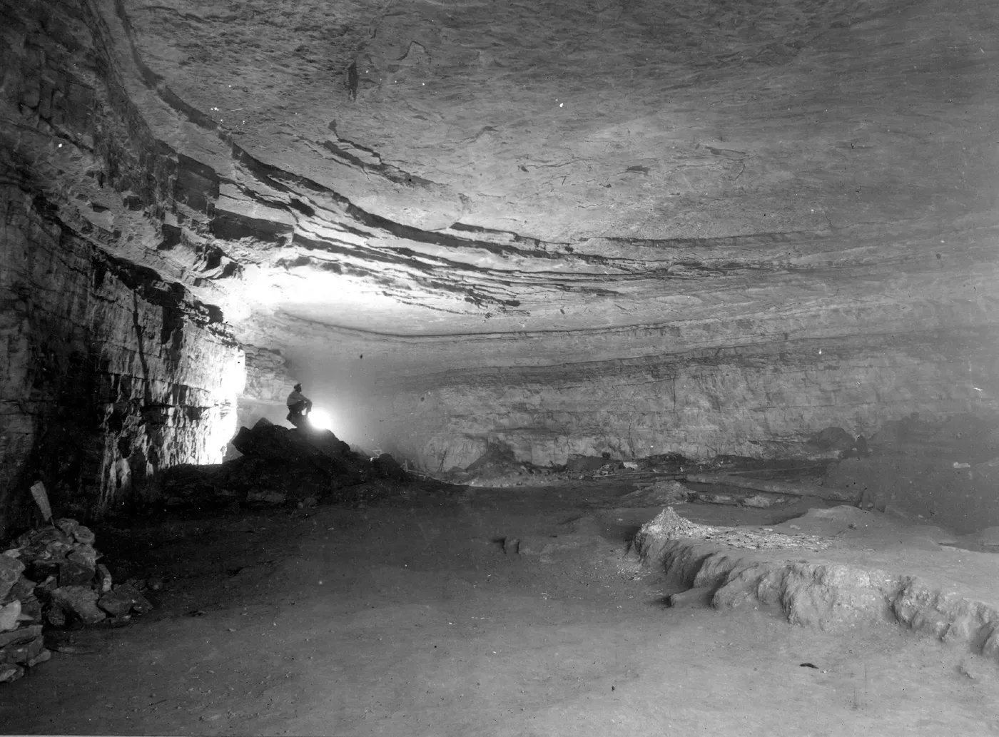
Most geological wonders stretch across the sky. Mammoth Cave stretches in the opposite direction, deep underground. As of 2025, more than 426 miles of passageways had been surveyed, over one and a half times longer than the second-longest cave system, Mexico’s Sac Actun underwater cave. To put that in perspective, that’s enough underground corridor to walk from New York City to Columbus, Ohio, without ever seeing daylight.
The sedimentary rocks that form the park were produced from sediments deposited when this area was submerged by an ancient ocean 330 million years ago, and the erosional force of the Green River has helped to carve the limestone into the unique and extraordinary karst topography of this region over millions of years. Mammoth Cave developed in Mississippian limestone covered by a layer of sandstone with limited permeability, and naturally acidic groundwater worked through cracks in the sandstone to melt away the limestone below. Water, patience, and chemistry. That’s all it takes to build the world’s most extraordinary underground network.
5. Half Dome, Yosemite, California: A Glacier’s Masterwork
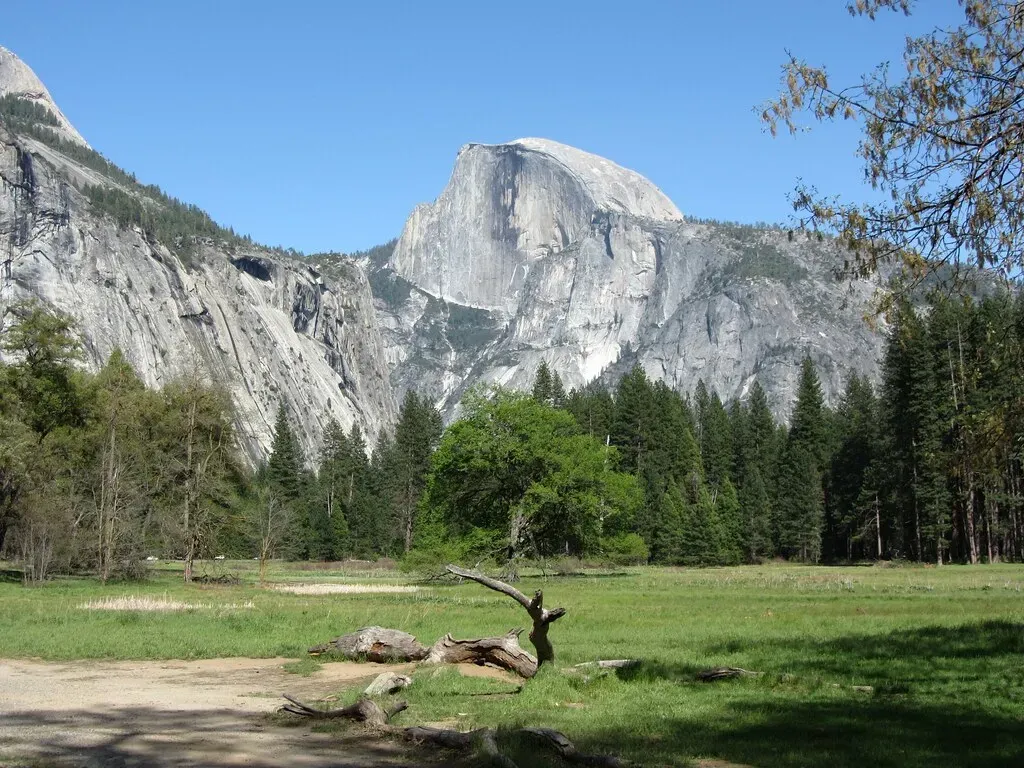
Half Dome is the classic and jaw-dropping example of an exfoliation dome, located in what is perhaps the world’s best example of a glacially carved canyon, and its rounded appearance is due to sheet jointing, also called exfoliation. It looks like some massive hand simply sliced it cleanly in two. In a way, that’s almost what happened.
The granitic pluton that formed the Sierra Nevada was slowly eroded, releasing pressure and causing the expansion of the underlying rock. Joints formed parallel to the Earth’s surface, which have since been exhumed and exposed, and the sheer vertical face of Half Dome parallels regional joints and was carved out by glaciers. Yosemite National Park features granite monoliths like El Capitan and Half Dome, sculpted by glaciers during the Ice Age. When you realize that ice shaped this extraordinary landscape, ice that has since entirely vanished, the scale of geological time becomes almost incomprehensible.
6. Crater Lake, Oregon: Born from a Volcanic Catastrophe

Crater Lake did not always exist. What stands in its place today was once a towering mountain, and its transformation into the deepest lake in the United States happened in a single catastrophic event. Just under 2,000 feet deep, Crater Lake is the deepest lake in the United States and the second deepest in the Western Hemisphere. Mount Mazama, at one time rising over 12,000 feet in the Cascade Range, erupted around 8,000 years ago, and the cataclysmic emptying of the magma chamber caused the mountain to collapse, forming a deep caldera that subsequently filled with rain and snowmelt, creating Crater Lake.
Formed around 7,700 years ago after the collapse of the Mount Mazama volcano, Crater Lake is the deepest lake in the United States, with a depth of nearly 2,000 feet. No streams flow in or out of the crater. The water you see there today is entirely made up of rain and snowfall accumulated over millennia. The lake is so isolated, so self-contained, that its clarity is almost unnerving. It’s electric blue, and the color doesn’t feel real.
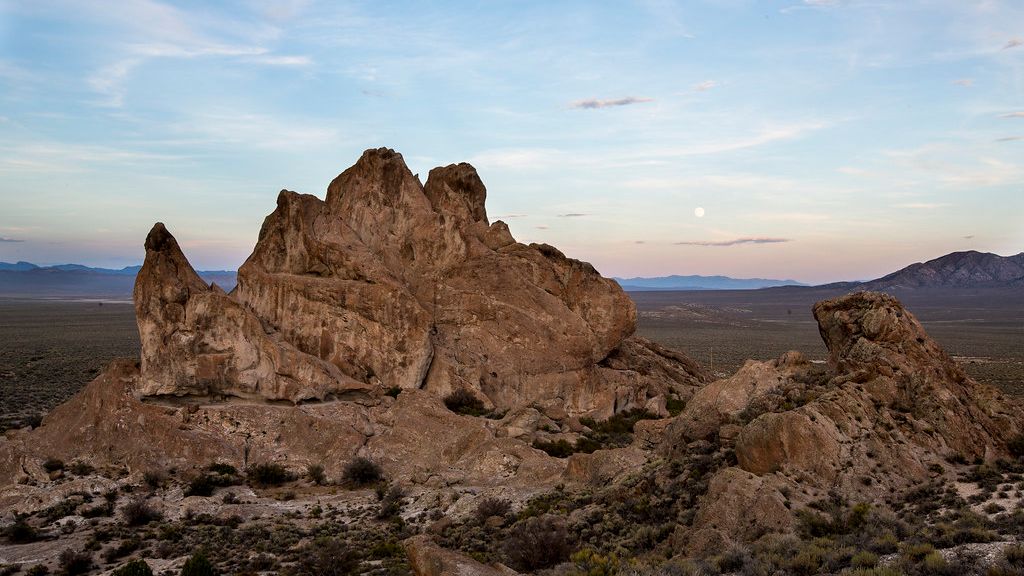
7. Devils Tower, Wyoming: A Volcanic Monolith That Defies Easy Explanation
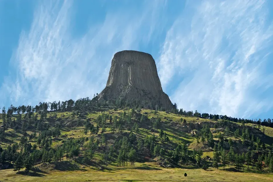
Rising nearly 1,300 feet above the surrounding plains of northeastern Wyoming, Devils Tower is the kind of formation that makes geologists argue and everyone else simply stare. Beyond Yellowstone, Devils Tower rises as a striking volcanic monolith, its columned structure unlike anything else in the country. It has the appearance of a massive bundle of hexagonal pencils bundled together, which sounds ridiculous until you’re actually standing in front of it.
The simplest explanation that can be offered is that it is a stock, a body formed by magma that cooled underground and became exposed due to erosion. Bits and pieces, sometimes even columns, of the formation are continuously eroding, meaning it was larger in the past and could eventually disappear. It’s hard to say for sure exactly what sequence of volcanic events created its perfectly symmetrical columns, but the result is genuinely one of the most striking landforms anywhere in North America. In Steven Spielberg’s 1977 film Close Encounters of the Third Kind, the formation in Moorcraft, Wyoming, was cast as a UFO landing zone, which honestly makes a certain kind of sense.
8. The Wave, Arizona and Utah: Wind-Painted Stone

Located on the border of Arizona and Utah within the Paria Canyon-Vermilion Cliffs Wilderness, The Wave is a mesmerizing and otherworldly geological formation that has become an iconic symbol of the American Southwest. You need a permit to get there, and those permits are extremely competitive, which means thousands of people enter a lottery every day just for the chance to visit. That alone tells you something.
The Wave is characterized by its undulating, wave-like patterns etched into the sandstone rock, creating a mesmerizing and dreamlike landscape. These intricate and delicate patterns were formed over thousands of years by the erosive forces of wind and water, sculpting the sandstone into a work of art. The result looks less like geology and more like painting. Every ripple, every curve, every gradient of red and orange tells the story of ancient dunes that once shifted across a desert that no longer exists.
9. Arches National Park, Utah: Over 2,000 Natural Stone Bridges

Most people expect to see a few arches when they visit Arches National Park. What they don’t always anticipate is the sheer number. Arches National Park alone holds over 2,000 stone arches, many standing precariously yet beautifully against desert skies. That’s not a typo. More than two thousand naturally formed arches in a single national park. It feels almost unreasonably generous for one place to have that many.
In the American Southwest, particularly within the Colorado Plateau, erosional processes have sculpted over 2,000 natural sandstone arches in Arches National Park, Utah, primarily from Jurassic Entrada Sandstone weakened by jointing, salt dissolution, and cycles of freeze-thaw weathering. The world-famous Delicate Arch, the remnant of a former fin, is one of the most striking, eye-catching, and well-photographed arches, while the airy Landscape Arch is one of the widest in the world with a base of over 300 feet. Walk through at sunset and the sandstone ignites. It’s the kind of place that makes you wonder why you ever thought skyscrapers were impressive.
10. Monument Valley, Arizona and Utah: The Southwest’s Cathedral of Stone
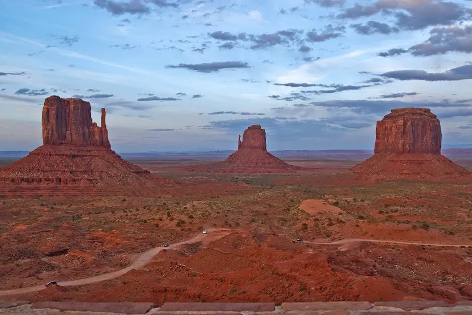
Stretching across the Arizona-Utah border, Monument Valley is one of the most iconic landscapes in America. Its towering red sandstone buttes rise from the desert floor like natural skyscrapers. You’ve seen this landscape in films and photographs countless times, and yet arriving in person still somehow surprises you. The scale simply cannot be communicated through a screen.
Monument Valley’s towering sandstone buttes rise dramatically from the desert floor, creating some of the most photographed views in the Southwest. The valley is part of the Navajo Nation, and guided tours share stories of its cultural and spiritual importance. Each formation has a name and a history tied to Navajo tradition. This is not just a geological wonder. It’s a living cultural landscape where the rocks carry meaning that extends far beyond the science. The geology and the human story are inseparable here.
11. The Badlands, South Dakota: An Alien World Written in Sediment

Badlands contains some of the world’s most bizarre and alien-looking landscapes, classic examples of badland topography. The poorly consolidated bedrock consisting of loose sediment and volcanic ash is quickly eroded by infrequent rainstorms. The resulting mud mounds, spires, and ridges resemble miniature mountain ranges. Driving into the Badlands for the first time genuinely feels like landing on another planet. Nothing in the surrounding flat prairie prepares you for it.
The richly textured landscape of the United States is a product of the dueling forces of plate tectonics, weathering, and erosion. Over the 4.5 billion-year history of the Earth, tectonic upheavals and colliding plates have raised great mountain ranges while the forces of erosion and weathering worked to tear them down. The Badlands are an almost perfect illustration of that process in real time. Every rainstorm reshapes them slightly, meaning the landscape visitors see today is different from what existed a century ago, and completely different from what will exist a century from now. In geological terms, you’re watching a slow-motion demolition in progress.
Conclusion: The Earth Beneath You Has Always Been Restless
What’s remarkable about all eleven of these formations isn’t just their beauty. It’s the fact that they exist at all. Each one survived billions of years of heat, ice, erosion, volcanic fury, and tectonic upheaval to become something you can walk up to and touch. From ancient canyons carved by rivers to towering volcanic peaks and unique rock formations, these sites tell a story billions of years in the making, serving as windows into Earth’s dynamic history and showcasing processes like erosion, volcanic activity, and plate tectonics.
The next time you stand at the rim of a canyon or under a towering arch, remember: you aren’t just a tourist at a scenic overlook. You are a tiny, brief presence in the middle of an incomprehensibly long story. The rocks were here long before us. They will likely outlast everything we’ve ever built. There’s something humbling about that, maybe even a little liberating. So which of these formations would you most want to stand in front of first? Tell us in the comments below.