There is a place tucked away in the quiet flatlands of northeastern Louisiana that most people have never heard of, yet it holds some of the most mind-bending secrets of the ancient world. It sits quietly on the edge of Macon Ridge, overlooking a river floodplain, hiding millennia of mystery beneath layers of earth and time. You might drive past the region without giving it a second thought. That would be a mistake.
Centuries ago, when Stonehenge was being built and Queen Nefertiti ruled Egypt, American Indians were building earthen monuments in north Louisiana. Hand by hand and basketful by basketful, men and women shaped nearly two million cubic yards of soil into stunning landscapes. The result was a massive 72-foot-tall mound, enormous concentric half-circles, and earthworks that dwarfed every other earthen monument site for over two thousand years. So, who were these people, and how on earth did they pull it off? Let’s dive in.
1. It Was Built by Hunter-Gatherers, Not Farmers – and That Changes Everything
Here’s the thing that truly blows archaeologists’ minds about Poverty Point. While research about the society that built Poverty Point continues, it is clear that those who moved the earth, basket by basket, were hunter-gatherers. The group that constructed it was always on the move, looking for plants and animals. Not cultivating crops for support in between hunts, they had to move frequently to access new food sources – making such a building feat utterly remarkable.
At nearly the same time as the pyramids were being built in Egypt, people in the New World were building cities, establishing trade routes that crossed thousands of miles, and creating a complex society in an age that predated agriculture. Hunter-gatherers, previously considered by archaeologists and anthropologists not to have a complex enough social structure to pull off monumental engineering, were leaving their mark on history in a spectacular fashion. Honestly, if that doesn’t rewrite your understanding of ancient human capability, nothing will.
2. The Scale of Construction Is Almost Incomprehensible
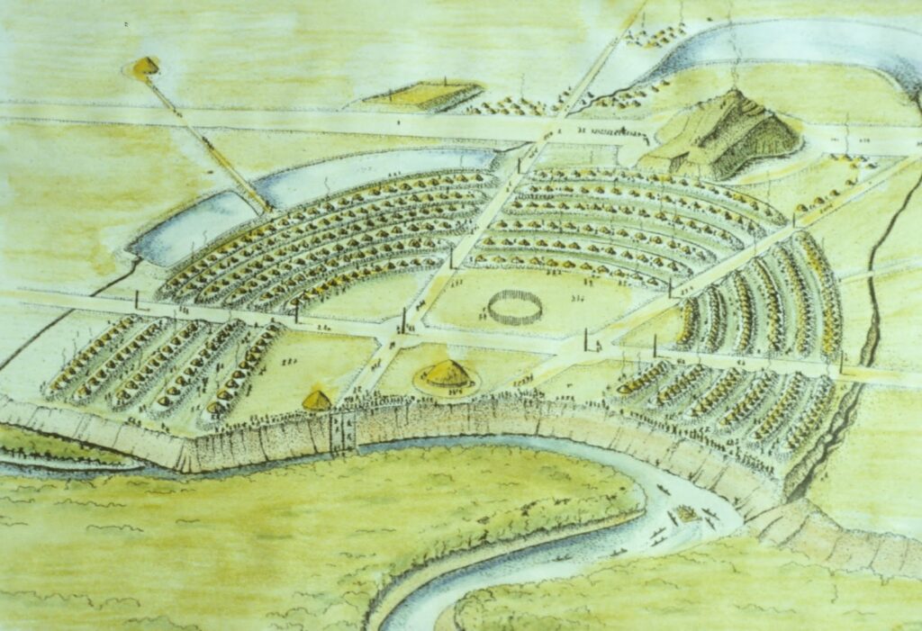
The Archaic Period people of the city gathered and moved over one million cubic meters of soil to create this lived-in environment. Spread out over seven square kilometers and never faced in stone, these structures and other public works blend into the land out of which they were built. Think about that for a moment – no machines, no wheels, no bulldozers. Just human hands and woven baskets, day after day.
Scientists estimate that roughly 53 million cubic feet of soil were moved during construction of the site, which was inhabited for 600 years. A cubic foot of soil weighs between 75 and 100 pounds. Conservatively, that is about 3.9 billion pounds of dirt – the equivalent of roughly 288,000 African elephants. And in case you’re wondering exactly how the Poverty Pointers moved the soil, the answer is: baskets. No wheels. No animals. Just baskets.
3. The Earthworks Held the Title of Largest in North America for Over Two Millennia
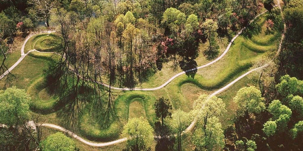
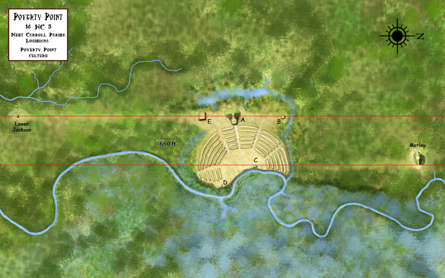
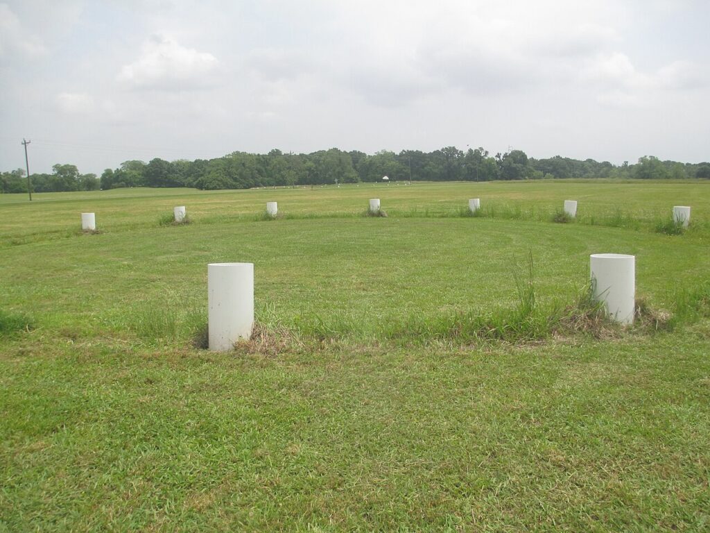
The complex comprises five mounds, six concentric semi-elliptical ridges separated by shallow depressions, and a central plaza. It was created and used for residential and ceremonial purposes by a society of hunter-fisher-gatherers between 3,700 and 3,100 years ago. It is a remarkable achievement in earthen construction in North America that was unsurpassed for at least 2,000 years. Let that sink in. Two thousand years of no rival. That is a record that makes most modern achievements look temporary.
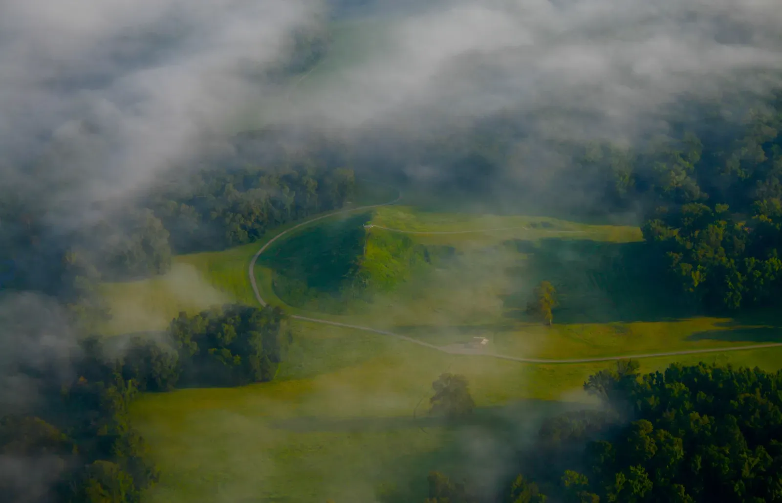
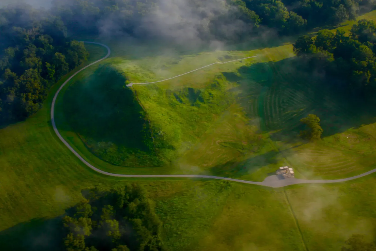
The mound complex is a singular achievement in earthen construction in North America – it was not surpassed for at least 2,000 years, and only then by people supported by a farming economy. The central construction consists of six rows of concentric ridges, parts of which were as high as five feet. The ridges form a semi-ellipse or C-shape, divided into sections by at least four aisles. The diameter of the outermost ridge measures nearly three-quarters of a mile. It’s hard to even picture this from ground level – which is partly why it wasn’t even recognized as man-made until the age of aerial photography.
4. Nobody Knew It Was Man-Made Until a Pilot Looked Down in the 1950s
The site is named after the plantation on which it was discovered in the mid-1800s, when it was believed to be a natural formation. It was not discovered to be man-made until the 1950s, when aerial photographs revealed the complex and sophisticated pattern of the earthwork. Imagine that. A masterpiece of ancient engineering, hiding in plain sight for thousands of years, mistaken for hills created by nature. It’s a little humbling, honestly.
Neither colonists nor archaeologists recognized these ridges as built monumental structures until the summer of 1953, when archaeologist James Ford happened to look at Army Corps aerial photographs of the region that revealed their distinct man-made composition. One accidental glance downward from a plane, and an entire chapter of human history was suddenly rewritten. In 1960, John Griffin, who at the time was the Southeast Regional Archaeologist for the National Park Service, suggested to the Federal government that Poverty Point be declared a national monument. At first the United States Congress declined to support the protection. The site was designated as a National Historic Landmark on June 13, 1962.
5. Poverty Point Was the Center of an Enormous Ancient Trade Network
At its peak 3,000 years ago, it was part of an enormous trading network that stretched for hundreds of miles across the continent. Since no stone of any kind is local to this part of the lower Mississippi, all stone would have been brought into the city through trade. You can almost think of Poverty Point as the ancient world’s version of a major port city – a place where goods, ideas, and people converged from vast distances.
When looking at the stone used for various artifacts and building purposes, scientists have found rocks and minerals at the site that came from as far north as Iowa and as far east as the Appalachians. When scientists discovered more than 70 tons of rocks there, it became clear the extent to which residents were involved in trade with other communities. Nearly 200 objects, including beads, pendants, needles, and thin sheets of copper, long thought to have come from the upper Midwest, have been found at Poverty Point. That is a trading web that would impress even modern logistics managers.
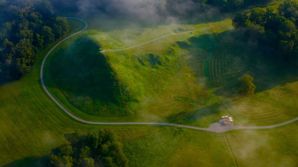
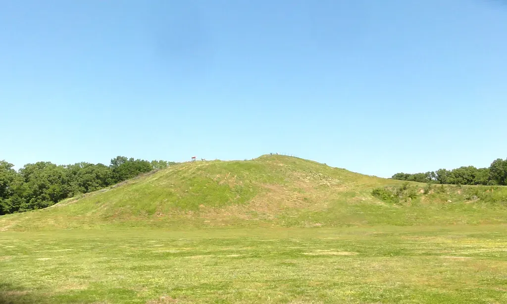
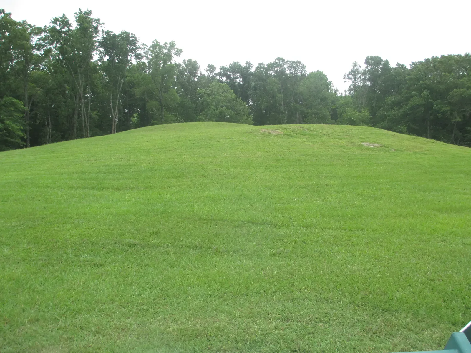
6. The Site’s Mound A Is One of the Largest Earthen Mounds in All of North America
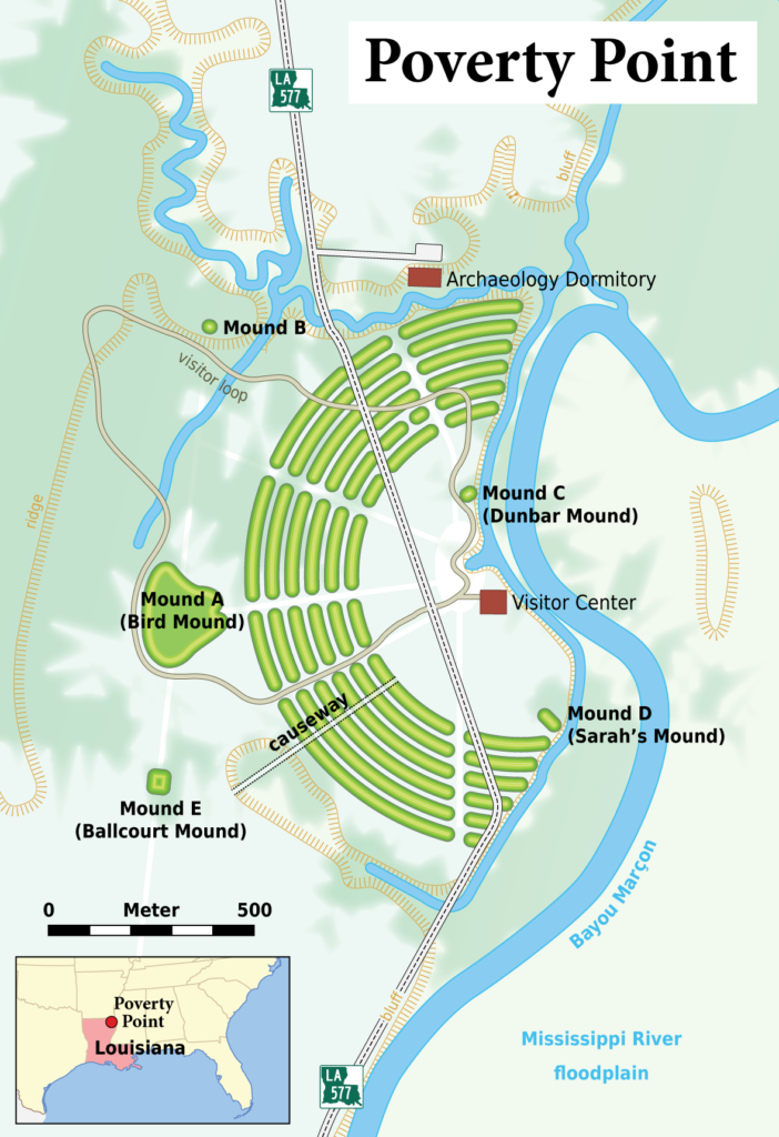
Around 1300 B.C.E., 350 years after they began building at the site, the people of Poverty Point built their last and largest monument, now known as Mound A. Carefully placed in the center behind the arched ridges, Mound A is seventy-two feet high, 710 feet long, and 660 feet wide. At its widest it appears like a set of outstretched wings, narrowing to a point like the beak of a bird flying west. It is a solid earthen structure built in three discernible stages.
To build each stage from the base elevation up, they purposefully used three distinct kinds of soil. These soils are different in color and composition and may have been gathered and used at each stage for conceptual or structural purposes. The careful arrangement of these soils further reveals the highly organized and conscious nature of this construction. This wasn’t random dirt-piling. It was deliberate, methodical, and engineered with an intent we are still working to fully understand.
7. The People Who Lived Here Had a Surprisingly Rich and Diverse Diet
The Poverty Point people’s food was acquired through fishing, gathering, and hunting. Their subsistence was broad-based due to the different seasonal foods that were available. Their diet consisted of large mammals like deer, small mammals like possum, various fish and turtles, mollusks, nuts, fruits, berries, and aquatic roots. Far from a desperate, wandering people scraping by, these were resourceful individuals who knew their environment inside and out.
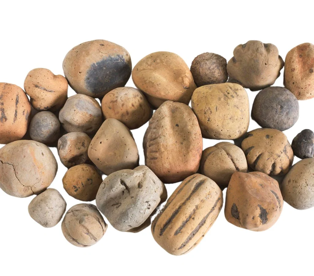
The vast majority of artifacts recovered at Poverty Point are small, baked shapes made of loess, found in a wide variety of forms referred to as “Poverty Point Objects” or PPOs. Archaeologists generally conclude the fired earth objects were used in cooking. When placed in earth ovens, the objects were shown to hold heat and aid in cooking food. Think of PPOs as the ancient equivalent of cooking stones – a clever, practical solution developed by people who had no access to metal pots or clay vessels for high-temperature cooking. It’s surprisingly ingenious.
8. Today It Holds UNESCO World Heritage Status – One of Very Few U.S. Sites to Do So
On June 22, 2014, at the 38th Session of the World Heritage Committee in Doha, Qatar, Poverty Point State Historic Site was inscribed as the 1,001st property on the World Heritage List. The Poverty Point complex is recognised internationally as an important site not just because of its scale, the integration of the earthworks, and the extent to which the complex is intact, but crucially because it was built by hunter-fisher-gatherers. That last point is everything. It’s what sets it apart from virtually every other monumental site on the planet.
Unlike some other sites that have been altered and tremendously disturbed by modern projects and excavations, it is estimated that less than one percent of the site has been disturbed. Though the population varied by season, the area was a large complex settlement that continued to have year-round occupants for over 600 years. Relatively little is known about the Poverty Point society’s name, language, or religion. In other words, you are looking at a site that is almost perfectly preserved, still holding the vast majority of its secrets – and that is both thrilling and deeply mysterious.
A Wonder That Refuses to Be Fully Explained
Poverty Point National Monument is one of those rare places that genuinely stops you in your tracks once you understand what you’re looking at. Archaeologists and anthropologists today continue to be puzzled over how such a loosely connected and constantly moving group of people could come together to fashion the complicated, planned mound complex at Poverty Point. The questions are still piling up faster than the answers, and that’s what makes this place so endlessly fascinating.
The city flourished through 1100 BCE, but the population seems to have declined after this time, and the city was abandoned sometime before around 500 BCE. No one knows why the people left Poverty Point any more than why others left the many sites abandoned across the continent. A civilization that rose to extraordinary heights simply walked away – leaving behind ridges, mounds, and millions of artifacts, but no written word, no explanation, and no farewell. It remains one of the great unresolved stories of the ancient Americas.
If you’ve never considered visiting a prehistoric earthwork site before, Poverty Point might just be the one to change your mind. It was built by ordinary people doing something extraordinary – without a single wheel, draft animal, or written blueprint. What do you think drives a community of wandering hunter-gatherers to build something meant to outlast them by thousands of years? Tell us in the comments.