You’ve probably heard of Atlantis. The legendary city swallowed by the sea, forever immortalized in stories and myth. Thing is, Atlantis isn’t the only place that vanished from our maps.
What if entire civilizations simply disappeared without a trace, leaving only whispers and scattered clues behind? We’re talking about worlds that once thrived with life, culture, and mystery. Some of these places were genuinely real, others perhaps embellished through time. Either way, they challenge everything we thought we knew about ancient history.
From continents consumed by rising seas to monuments older than the pyramids, these lost worlds spark endless questions. So let’s dive in. Get ready to explore ten fascinating places that history nearly forgot.
Atlantis: The Legend That Won’t Die
The legend of Atlantis began with ancient Greek philosopher Plato, who described a technologically advanced civilization that supposedly sank into the ocean in a single day and night of misfortune. Around 360 B.C., Plato described a powerful, advanced island civilization that existed 9,000 years before his time, located beyond the Pillars of Hercules with glorious architecture, advanced technology, and a strong military. Honestly, the story sounds almost too perfect to be true.
Most historians and scientists throughout history have concluded that Plato’s account of the lost kingdom was fictional, arguing the Greek philosopher invented Atlantis as his vision of an ideal civilization and intended the story of its demise to be a cautionary tale of the gods punishing human hubris. No written records of Atlantis exist outside of Plato’s dialogues, and despite modern advances in oceanography and ocean-floor mapping, no trace of such a sunken civilization has ever been found.
Yet theories persist. One of the most widely accepted theories links Atlantis to the Minoan civilization on the island of Crete and the nearby volcanic island of Thera, modern Santorini. Recently, archaeologist Michael Donnellan announced a discovery he believes could be the legendary lost city, asserting he found submerged structures off the coast of Cádiz, Spain, which correspond closely with descriptions given by Plato. The debate rages on.
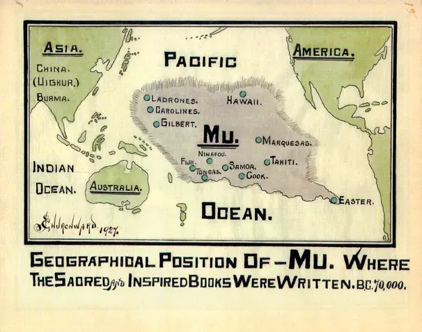
Lemuria and Mu: Continents of the Imagination
Lemuria started as a legitimate scientific hypothesis gone wild. British zoologist Philip Sclater wrote an essay in 1864 wondering how Madagascar could be home to dozens of species of lemurs while the entire continents of Africa and India had what he believed to be far fewer. His solution? A lost continent connecting them.
During the latter part of the 19th century, Helena Blavatsky, occultist and founder of theosophy, placed Lemuria in her mystical-religious doctrine, claiming this continent was the homeland of human ancestors called Lemurians, and her writings had a significant impact on Western esotericism, popularizing the myth. Things got stranger from there. Blavatsky claimed the ancient Lemurians were giant, 15-foot-tall hermaphrodites with four arms who lived alongside the dinosaurs.
James Churchward later popularised Mu as an alternative name for a lost Pacific Ocean continent in a series of books, beginning with Lost Continent of Mu, the Motherland of Man in 1926, followed by The Children of Mu and The Sacred Symbols of Mu. Lemuria finally fell off the map in the 1960s when Alfred Wegener’s theory of plate tectonics became widely accepted, as tectonic activity explains continental drift, which eliminates the need for hypothetical land bridges. Still, believers remain to this day.
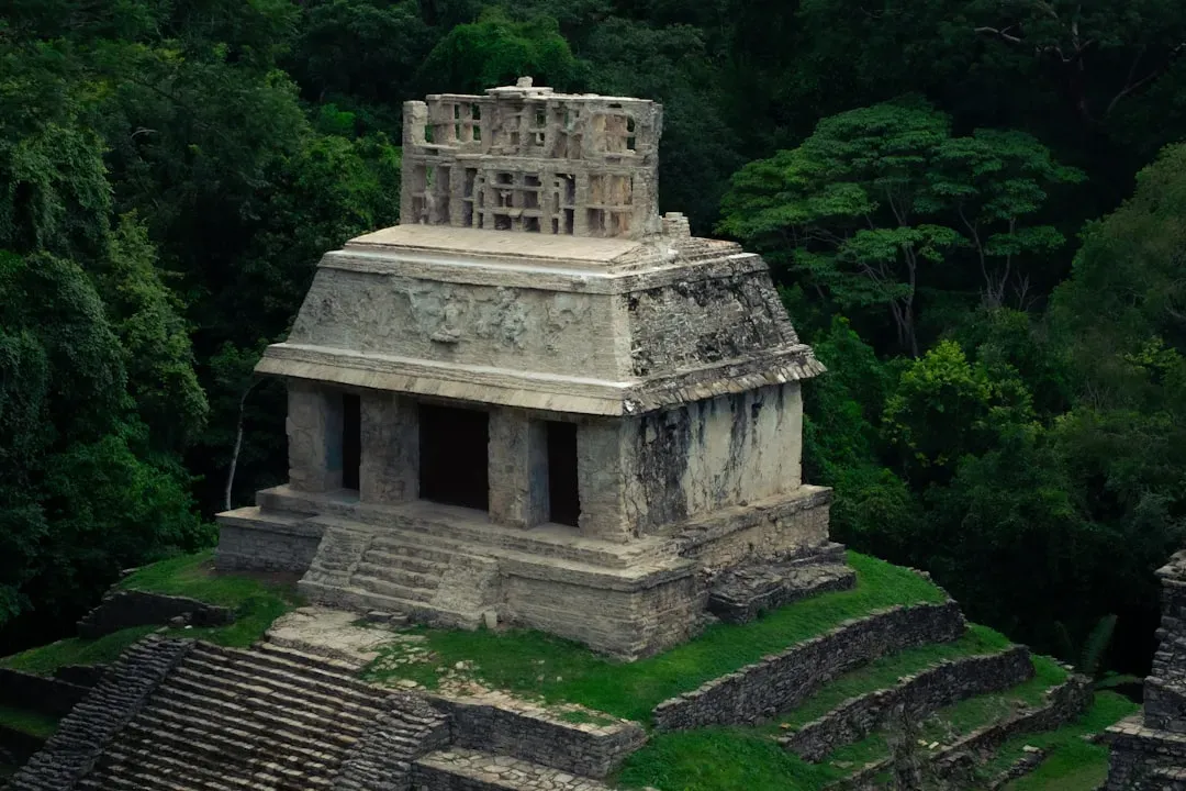
Göbekli Tepe: The Temple That Shouldn’t Exist
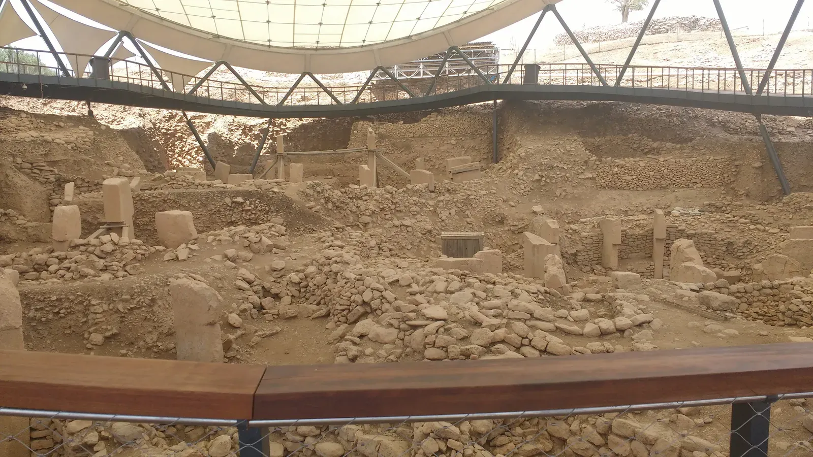
Let’s be real, Göbekli Tepe changes everything. Massive carved stones about 11,000 years old, crafted and arranged by prehistoric people who had not yet developed metal tools or even pottery, predate Stonehenge by some 6,000 years, and the place is called Göbekli Tepe, which a German archaeologist who has worked there is convinced is the site of the world’s oldest temple.
Known as Göbekli Tepe, the megalithic settlement is perched on a mountain ridge in Upper Mesopotamia, what is now southeastern Turkey, and the Neolithic site, which translates to belly hill in Turkish, is two times older than Stonehenge and contains a series of elaborate circular enclosures constructed of massive T-shaped limestone columns. Many of the pillars feature intricate carvings of abstract symbols and wild animals, including lions, foxes, gazelles and birds.
Here’s the thing that blows my mind. Göbekli Tepe’s builders were on the verge of a major change in how they lived, thanks to an environment that held the raw materials for farming, and within 1,000 years of its construction, settlers had corralled sheep, cattle and pigs, and at a prehistoric village just 20 miles away, geneticists found evidence of the world’s oldest domesticated strains of wheat with radiocarbon dating indicating agriculture developed there around 10,500 years ago. The temple may have come before the city, not the other way around.
Doggerland: Europe’s Drowned Heartland
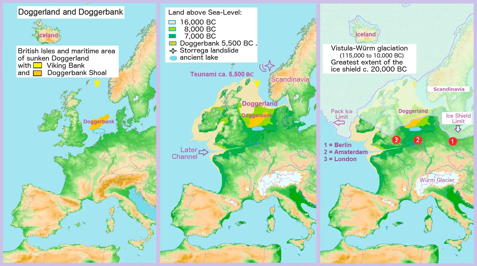
Doggerland was a large area of land in Northern Europe, now submerged beneath the southern North Sea. Picture this: where fishermen now trawl for cod, thousands of people once hunted deer and gathered hazelnuts. During the early Holocene following the glacial retreat at the end of the Last Glacial Period, the exposed land area of Doggerland stretched across the region between what is now the east coast of Great Britain, northern France, Belgium, the Netherlands, north-western Germany, and the Danish peninsula of Jutland.
Between 10,000 and 7,000 years ago, Doggerland was inundated by rising sea levels, disintegrating initially into a series of low-lying islands before submerging completely. The end came dramatically. Researchers have confirmed a tsunami, triggered by an underwater landslide near Norway known as the Storegga slides, hit around 6150BCE.
In the late 1990s this mysterious Mesolithic land finally received a name, with the term Doggerland coined by University of Exeter archaeologist Bryony Coles, who named it after Dogger Bank, a submerged sandbank 60 miles off the English coast frequented by Dutch fishing vessels known as doggers. For the past half-century, beachcombers and hobbyists searching the coastal and intertidal zones have collected harpoon tips, flint shards, and mammal bones, as well as fragments of human skulls, femurs, and jaws. It’s like finding pieces of Atlantis, except this one was actually real.
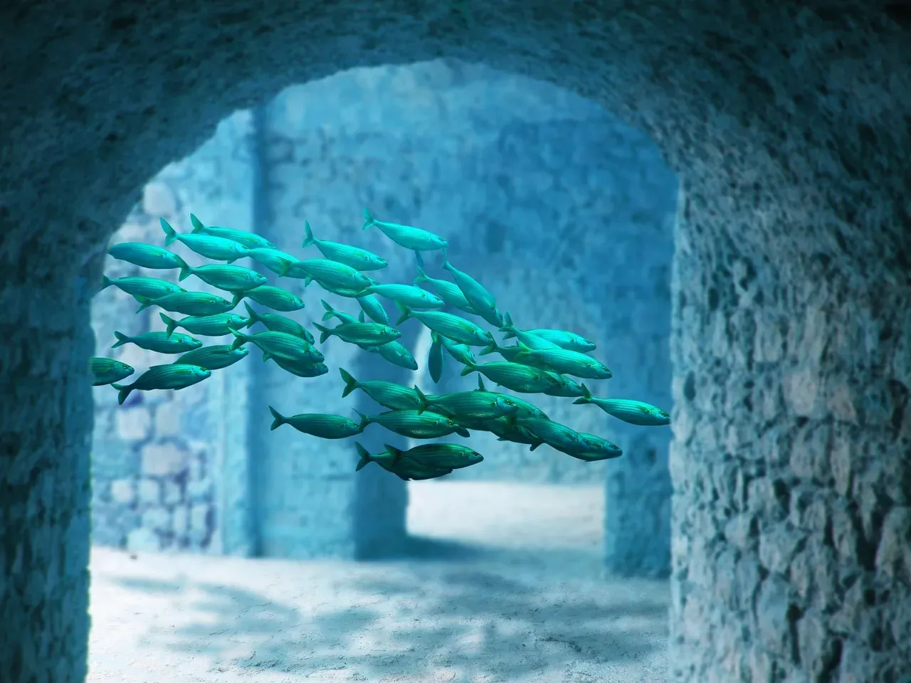
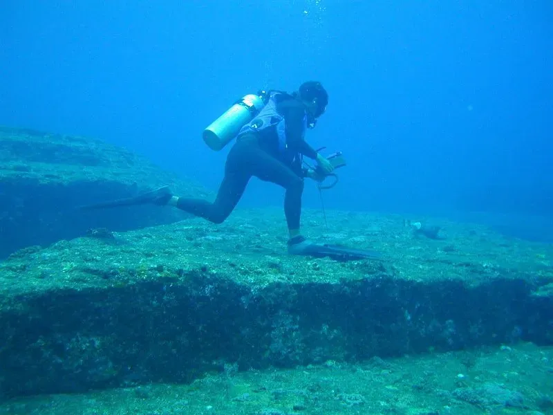
Thonis-Heracleion: Egypt’s Sunken Gateway
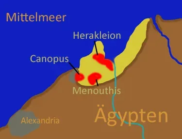
About 2,700 years ago, the Egyptian port city Thonis-Heracleion served as the gateway to the Mediterranean, but the urban center was lost in time for thousands of years until the early 2000s when a group of divers stumbled upon some ancient artifacts and eventually discovered that an entire city was buried underwater off the Egyptian coast, complete with bridges, 16-foot statues, animal sarcophagi and other ancient marvels.
An Egyptian port city on the Mediterranean Sea, Thonis-Heracleion served as a major trading hub prior to the founding of nearby Alexandria around 331 B.C., and mythical hero Heracles and Helen of Troy both supposedly spent time there. Talk about legendary real estate. Around the second century B.C., the city center collapsed due to soil liquification, possibly triggered by earthquakes, tsunamis, or floods, and eventually all of Thonis-Heracleion sank underwater where it remained lost to time until being rediscovered in the early 2000s by marine archeologists.
Since then, large statues, animal sarcophagi, temple ruins, pottery shards, jewelry, coins, and even 2,400-year-old fruit baskets have been pulled from the waves, thus shining new light on this real-life Atlantis. The city’s preservation is remarkable, offering insights into ancient Mediterranean trade and culture.
The Indus Valley Civilization: An Enigma in Plain Sight
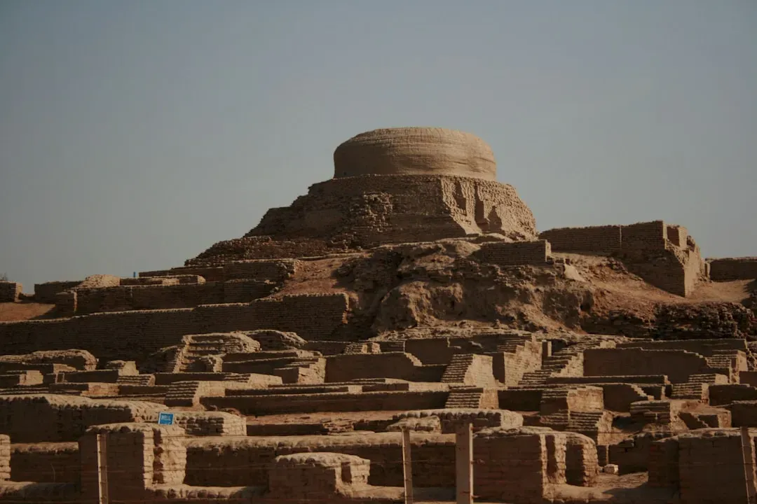
The Indus civilization, also known as the Harappan civilization, was one of the largest in ancient history, extending over parts of India, Pakistan, and Afghanistan and containing as many as five million people. Evidence shows that the Indus Valley Civilization had developed highly advanced agricultural and sewage systems for its time, and it also had a written language and accounted for 10% of the world’s population at the time of its peak.
Then it vanished. The Indus thrived until around 1800 BC when most of the population began emigrating from their cities. While it was once believed that the Indus were pushed out by an Aryan invasion, further research reveals that was not the case, with recent research instead pointing towards a shift in the monsoon cycle, which would have greatly impacted their ability to produce crops.
Some suggest that many of the river banks dried up before a sudden flood came through, wiping out more of the population, and other natural events such as earthquakes or epidemics may have also contributed to the Harappans’ sudden demise. The mystery deepens because their written script remains undeciphered. Without understanding their language, we’re left guessing about their culture, beliefs, and ultimate fate.
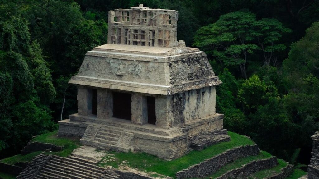
The Maya Collapse: When Cities Turned to Jungle
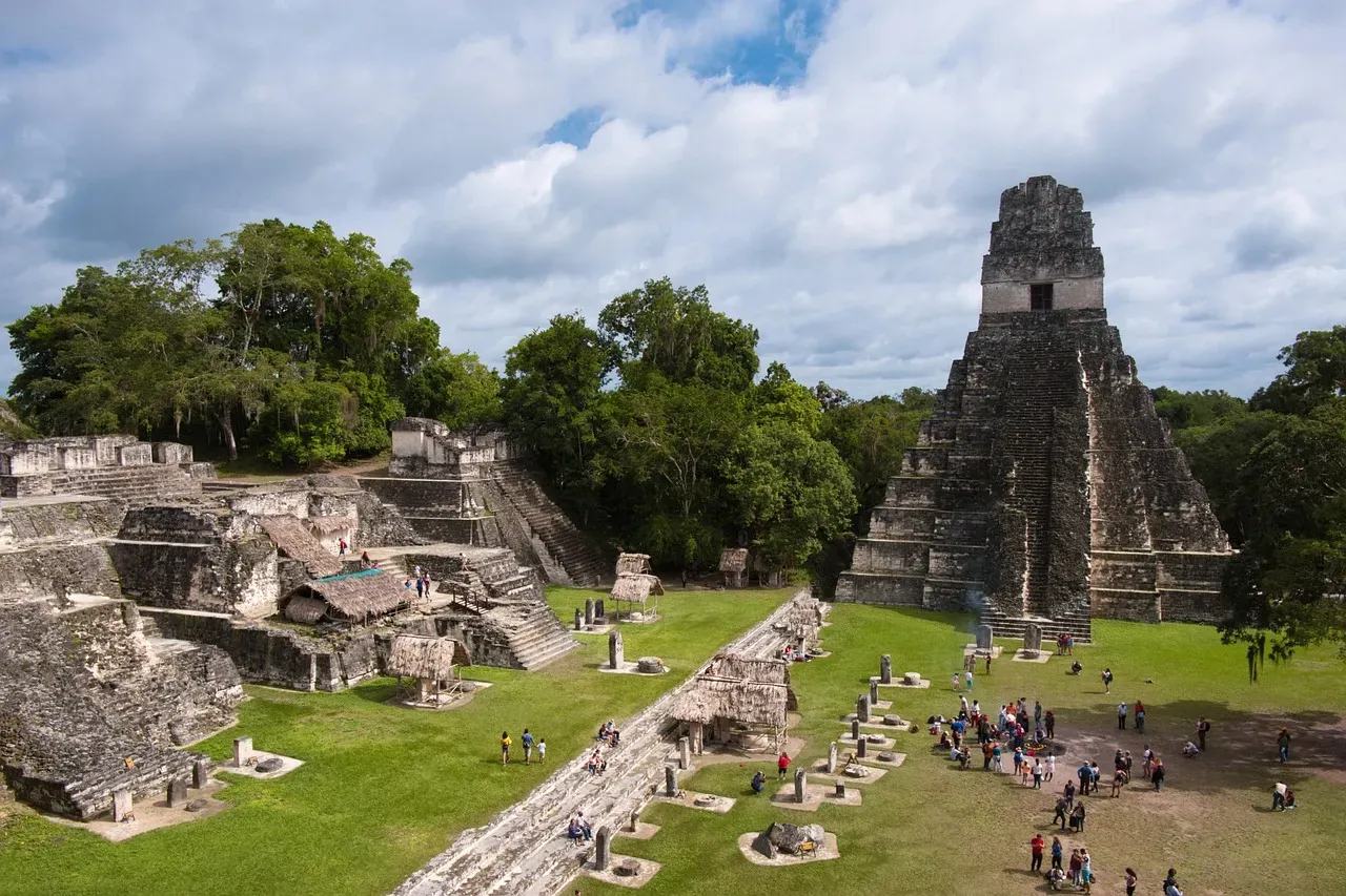
The Maya Empire was once located in modern-day Mexico, Guatemala, and Belize, and at the time, the Maya were one of the most advanced civilizations on Earth, known for their mathematical, architectural, and engineering abilities. This lost civilization contained large cities, monuments, and roads, as well as technologies that helped advance their growing communities, and between massive pyramids and terraced farms, the Maya civilization achieved some impressive feats.
Around 900 AD, the Maya civilization experienced a drastic decline, and within just a few decades, the population had been wiped out by seemingly mysterious forces. I know it sounds crazy, but entire cities were simply abandoned. Historians suggest that this decline was probably due to significant climate change and natural disasters in the region, as well as ongoing warfare and famine throughout their cities.
The jungle slowly reclaimed their magnificent stone temples. By the time Spanish conquistadors arrived centuries later, most Maya cities were already ghost towns, their towering pyramids hidden beneath thick vegetation. The collapse remains one of archaeology’s most debated mysteries.
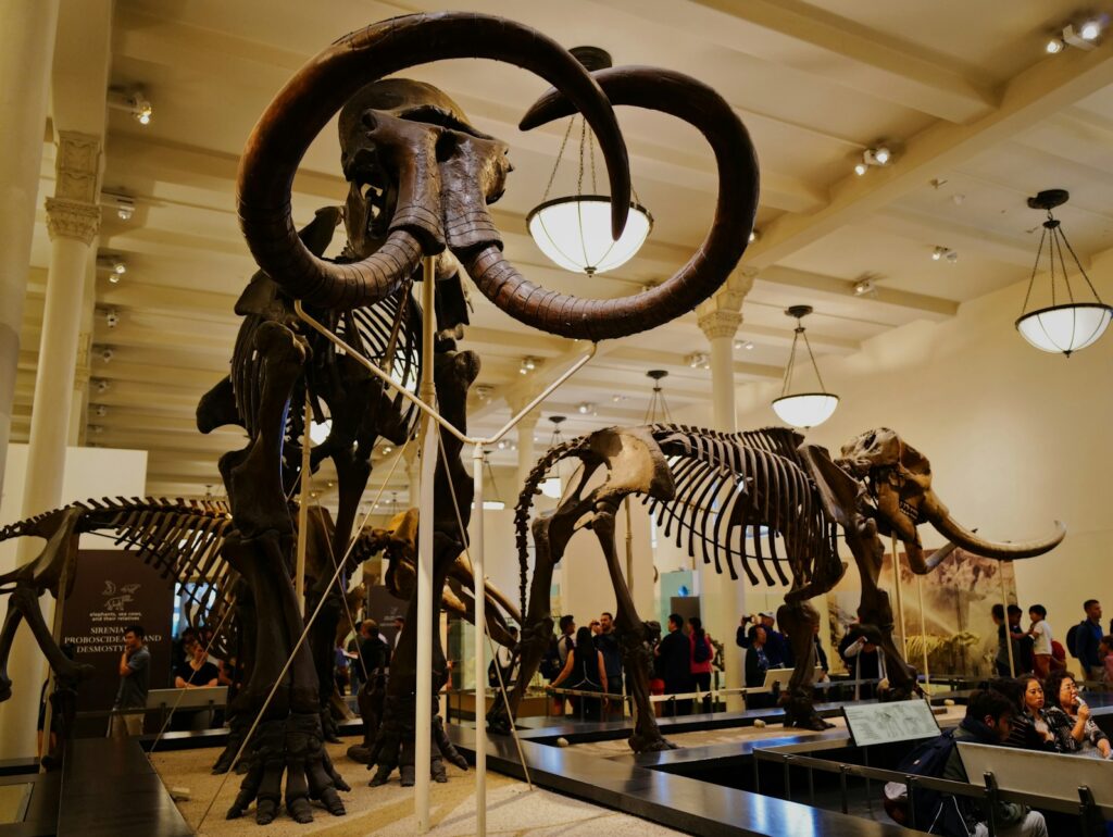
Cahokia: North America’s Forgotten Metropolis
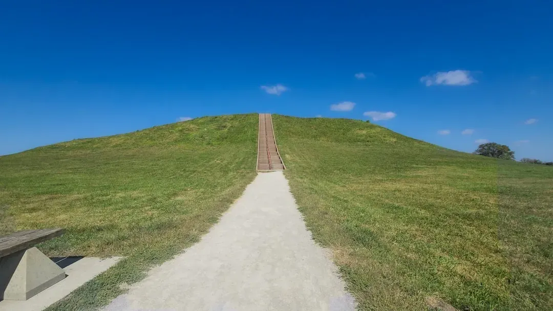
One of their largest cities, Cahokia, was located near modern-day Collinsville, Illinois, estimated at six square miles, featuring a massive central plaza, large earthen pyramids, and wood structures similar in shape to Stonehenge that were used to track the stars. Some estimate the population of Cahokia at 40,000, with many living in villages outside the main city.
That’s larger than London was at the same time. Yet most people have never heard of it. This city was known for its buildings, plazas, and massive mounds across the region, and there were approximately 120 earthen mounds across Cahokia, one of which was over 100 feet tall and required 14 million baskets of dirt to create.
Experts don’t know with certainty what led to the gradual demise of the Mississippians, with popular theories suggesting that the decline was the result of environmental degradation or of famine and disease resulting from poor sanitation. According to experts, the population was washed out, literally, by a massive flood sometime around 1200 AD. The site stands today as a haunting reminder of a sophisticated civilization that history nearly erased.
Angkor: The Jungle’s Hidden Empire
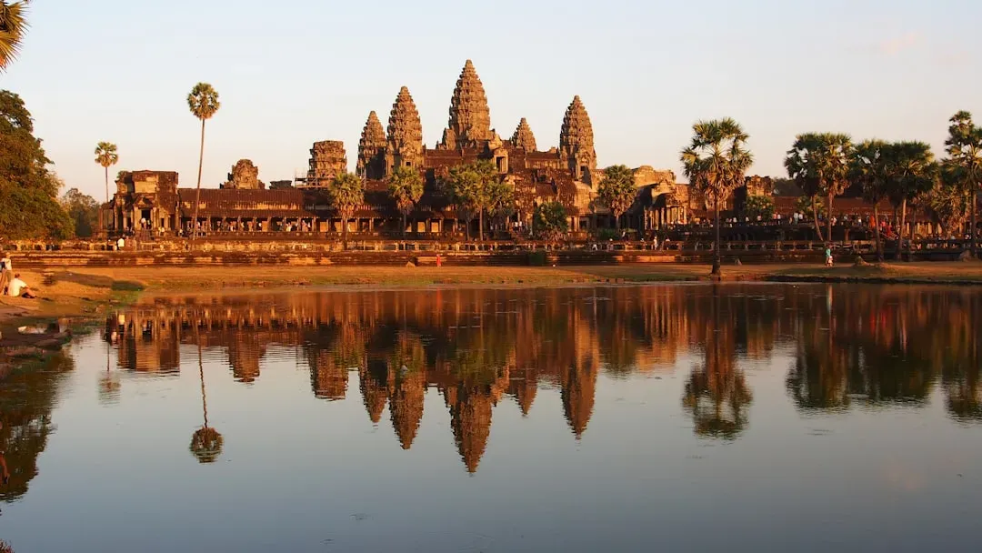
On the other side of the world, the Khmer empire had spread across modern-day Cambodia, and Angkor was one of the civilization’s largest cities, with an extensive system of roads and canals and an estimated population of as many as one million people. The scale is staggering when you think about it.
The Khmer empire was at its height between 1000 and 1200 CE, and experts are unsure what caused the civilization to disappear, leaving its cities at the mercy of the relentless jungle, with theories ranging from war to environmental catastrophe. Trees grew through temple roofs, roots wrapped around stone faces, and nature reclaimed what humans had built.
Unlike some lost worlds, Angkor was rediscovered relatively recently, with French explorers stumbling upon the magnificent ruins in the mid-1800s. Today, Angkor Wat remains the largest religious monument in the world, a testament to the architectural genius of the Khmer people. Yet the question lingers: why did they abandon such a magnificent city?
Yonaguni Monument: Nature or Lost Civilization?
The Yonaguni Monument was first discovered in the 1980s off the coast of Japan by a team of divers, and the so-called monument resembles what some people call the ruined remains of a lost civilization that has since fallen into the ocean. Off the coast of Japan’s Yonaguni Island lies an underwater rock structure, at least 165 feet long and 65 feet wide, that resembles a manmade step pyramid, and discovered in the 1980s and now known as the Yonaguni Monument, it is believed by some researchers to be the ruins of an ancient civilization.
Here’s where things get controversial. Many other researchers contend that Japan’s Atlantis is nothing more than a curious natural phenomenon shaped by tectonic uplift and ocean currents. Historians, archeologists, and geologists have heavily disputed this Japanese Atlantis as nothing more than a natural formation of rocks at the bottom of the ocean caused by the movement of plate tectonics, and the Yonaguni Monument will most likely remain a source of endless intrigue and mystery until further research and exploration of the site are conducted.
Geometric shapes, right angles, what appear to be stairs. Natural erosion or ancient engineering? The debate continues, with passionate advocates on both sides refusing to budge.
What Do These Lost Worlds Tell Us?
These ten lost worlds share common threads. Rising seas, changing climates, natural disasters, and human choices all played roles in their disappearance. Throughout the course of human history, great civilizations have been built, thrived, and declined, and some seem to have suddenly disappeared, with some civilizations leaving clues as to what caused their demise while the loss of others remains a mystery.
Those studying the Doggerland area are finding that the climate change faced by Mesolithic people is analogous to our own, as Mesolithic peoples were forced out of Doggerland by rising water that engulfed their low-lying settlements, and climate scientists say that a similar situation could affect the billions of people who live within 60 kilometers of a shoreline today, if polar ice caps continue to melt at an accelerated pace.
The past isn’t as dead as we think. These lost worlds whisper warnings and remind us that even the mightiest civilizations can crumble. Göbekli Tepe challenges our assumptions about human development. Doggerland proves entire landscapes can vanish beneath the waves. The Maya collapse demonstrates that environmental pressures can topple empires.
Every discovery raises more questions. How many other lost worlds lie buried or submerged, waiting to be found? What happened to the people who lived there? And perhaps most importantly, what can we learn from their stories to avoid repeating their mistakes? continue to unravel, one fascinating discovery at a time.