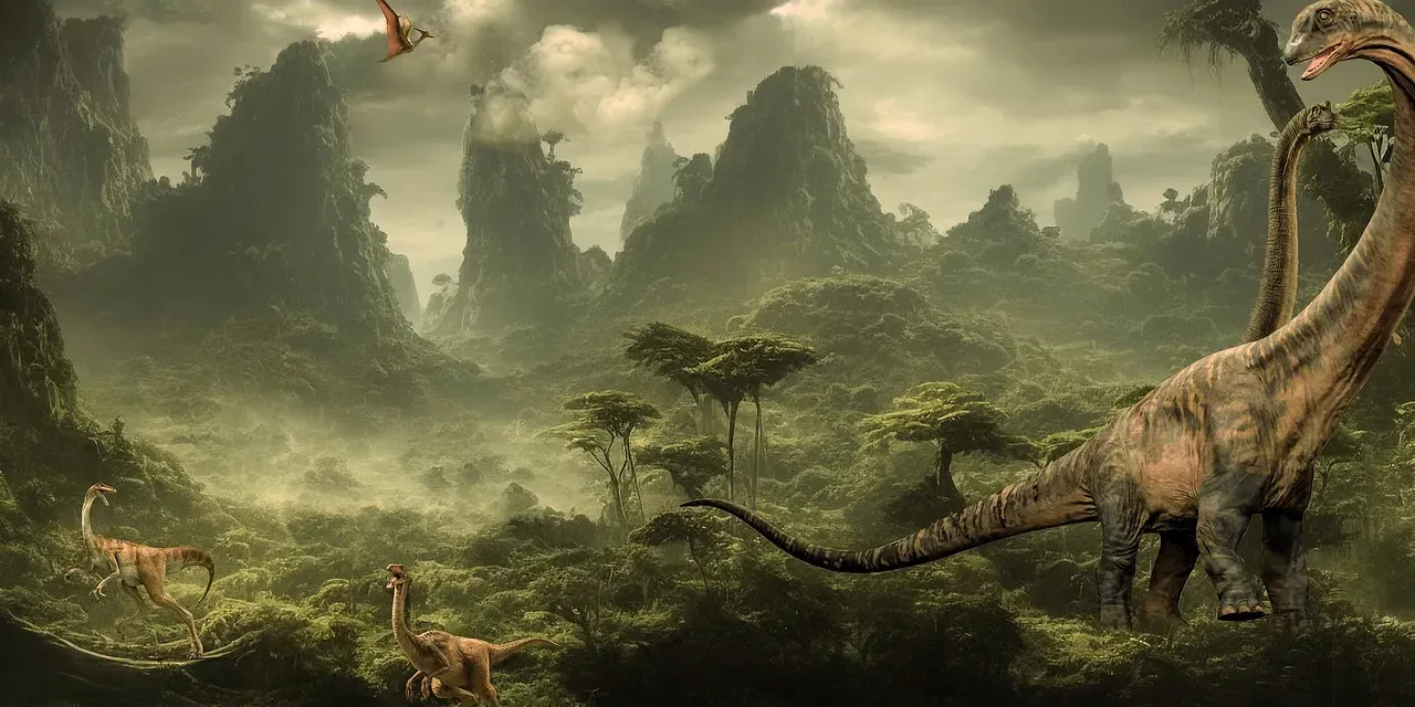
You might think you know the story of North American dinosaurs, but what shaped the very ground they walked on? Long before Triceratops roamed the plains and Tyrannosaurus stalked its prey, massive geological forces were quietly writing the script. The continents weren’t where they are today. Oceans sliced through landmasses. Mountains rose from flat earth, and ancient supercontinents tore themselves apart. These weren’t just background scenery for the dinosaur drama. They were the stage directors.
The landscapes we imagine when we picture dinosaurs existed only because continents collided, drifted, and split with devastating force. What you’ll discover is that geology didn’t just provide a home for these creatures. It created isolated kingdoms, evolutionary hotspots, and extinction zones. So let’s dive in.
The Assembly of Pangaea and the Dawn of the Dinosaur Age
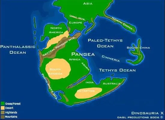
Before the Triassic began, approximately 252 million years ago, the plates had moved in such a way that all of the major landmasses had collided with each other, forming a supercontinent which is called Pangea. Picture nearly all the land you know crammed into one massive chunk surrounded by a single vast ocean. The Appalachians are part of a zone of continental collision that includes the Marathon and Ouachita Mts. in the United States, the Atlas Mountains in Africa, and the Caledonide Mountains in Greenland, the British Isles, and Scandinavia.
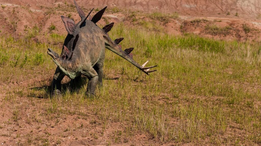
This wasn’t a peaceful union. When continents smash together, they don’t just bump and bounce off. When this happens, their edges are thrust up into mountains if neither plate is denser than the other. The collision zone created some of the tallest peaks Earth had ever seen. The impact completed the assembly of Pangaea and drove the Appalachian region to Himalayan-scale elevation. Imagine mountains towering where gentle rolling hills now stand. The Late Triassic also saw the origin of the dinosaurs, and they had reached the east coast of the United States not long after they evolved in the first place. These early dinosaurs weren’t walking across the sprawling continent we know. They were navigating a very different world.
The Breakup of Pangaea and Rift Valley Habitats
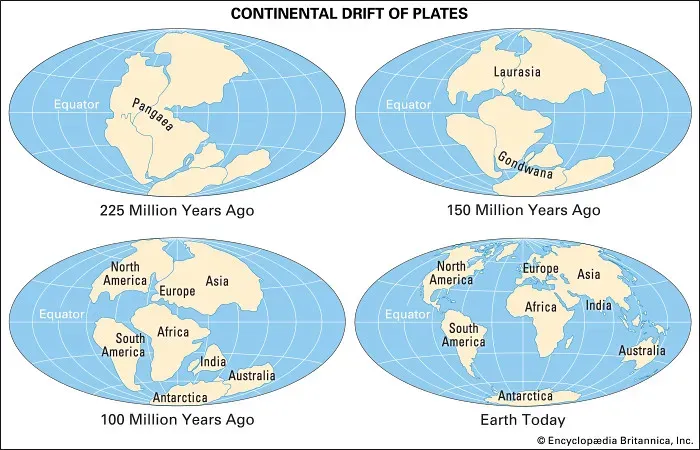
Pangea began to break up toward the end of the Triassic, first along the boundary between North America and Africa. Nothing lasts forever, especially supercontinents. The forces that built Pangaea eventually reversed, tearing it apart with volcanic fury. Pangea first began to be torn apart when a three-pronged fissure grew between Africa, South America, and North America, with rifting beginning as magma welled up through the weakness in the crust, creating a volcanic rift zone.
As the two continents began to move in different directions, long narrow rift valleys formed along the seam, and the eastern margin of North America in the Late Triassic featured a number of long, linear lakes and basins, from Nova Scotia to South Carolina. These weren’t ordinary lakes. They were deep basins flanked by active faults and volcanoes, creating unique microclimates. Think of the East African Rift Valley today but filled with dinosaurs instead of elephants. Early dinosaurs flourished in these rift valleys, leaving behind abundant footprints but surprisingly few bones. The sedimentary rocks preserved in the rift basins record the presence of dinosaurs in the Northeast.
The Formation of the Western Interior Seaway
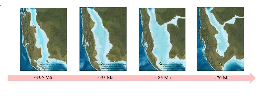
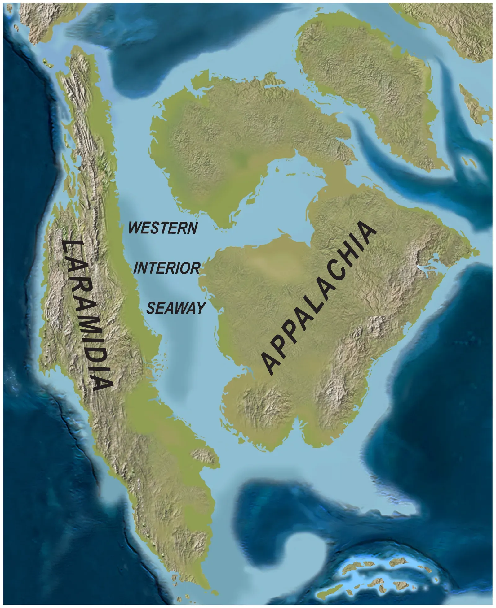
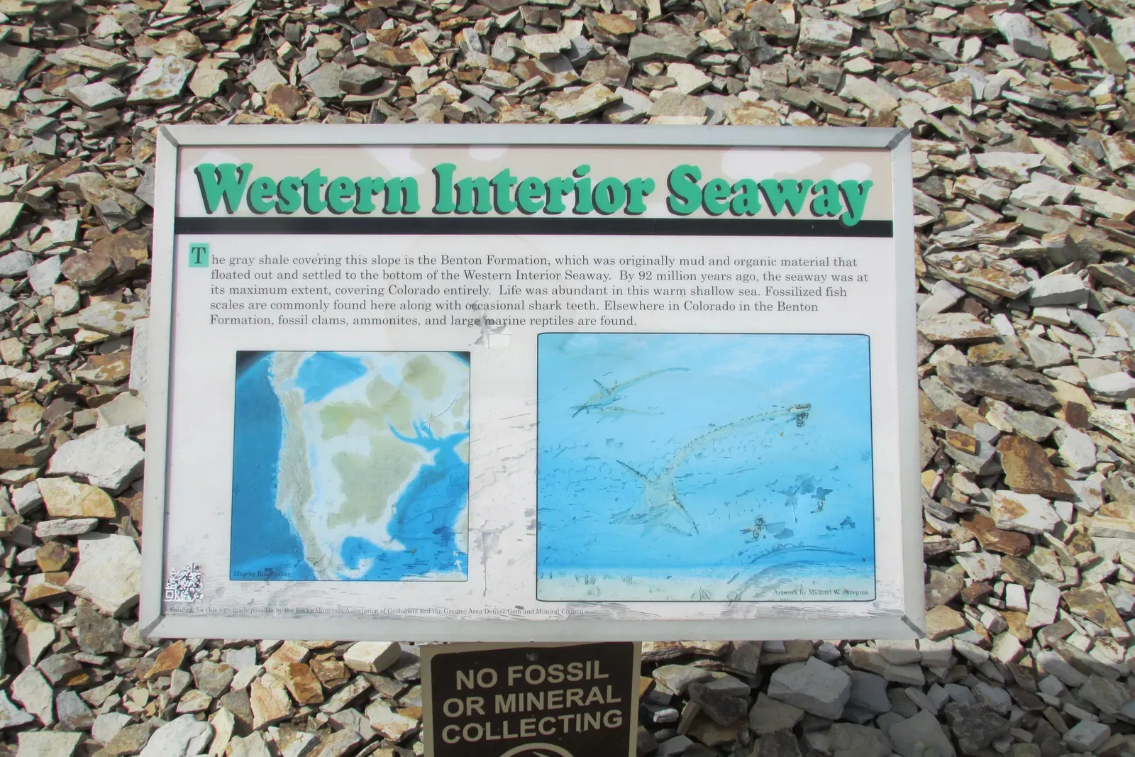
Here’s where things get wild. The Western Interior Seaway was a large inland sea that existed roughly over the present-day Great Plains of North America, splitting the continent into two landmasses, Laramidia to the west and Appalachia to the east, and existed for 34 million years from the early Late Cretaceous to the earliest Paleocene. Imagine standing in Kansas and looking out at ocean water stretching to the horizon. Not a distant coastline. An actual sea, hundreds of meters deep.
The ancient Farallon and Kula tectonic plates were in the process of subducting beneath the North American Plate, which caused the overlying land to warp and form a large back-arc basin, with ocean waters beginning to fill in the basin during a series of sea level increases, producing the Western Interior Seaway. This wasn’t just any body of water. At its largest extent, the seaway was 2,500 ft deep, 600 mi wide and over 2,000 mi long. The seaway turned North America into two isolated island continents. Dinosaurs on one side evolved independently from those on the other, like Darwin’s finches but on a continental scale.
Laramidia: The Western Dinosaur Kingdom
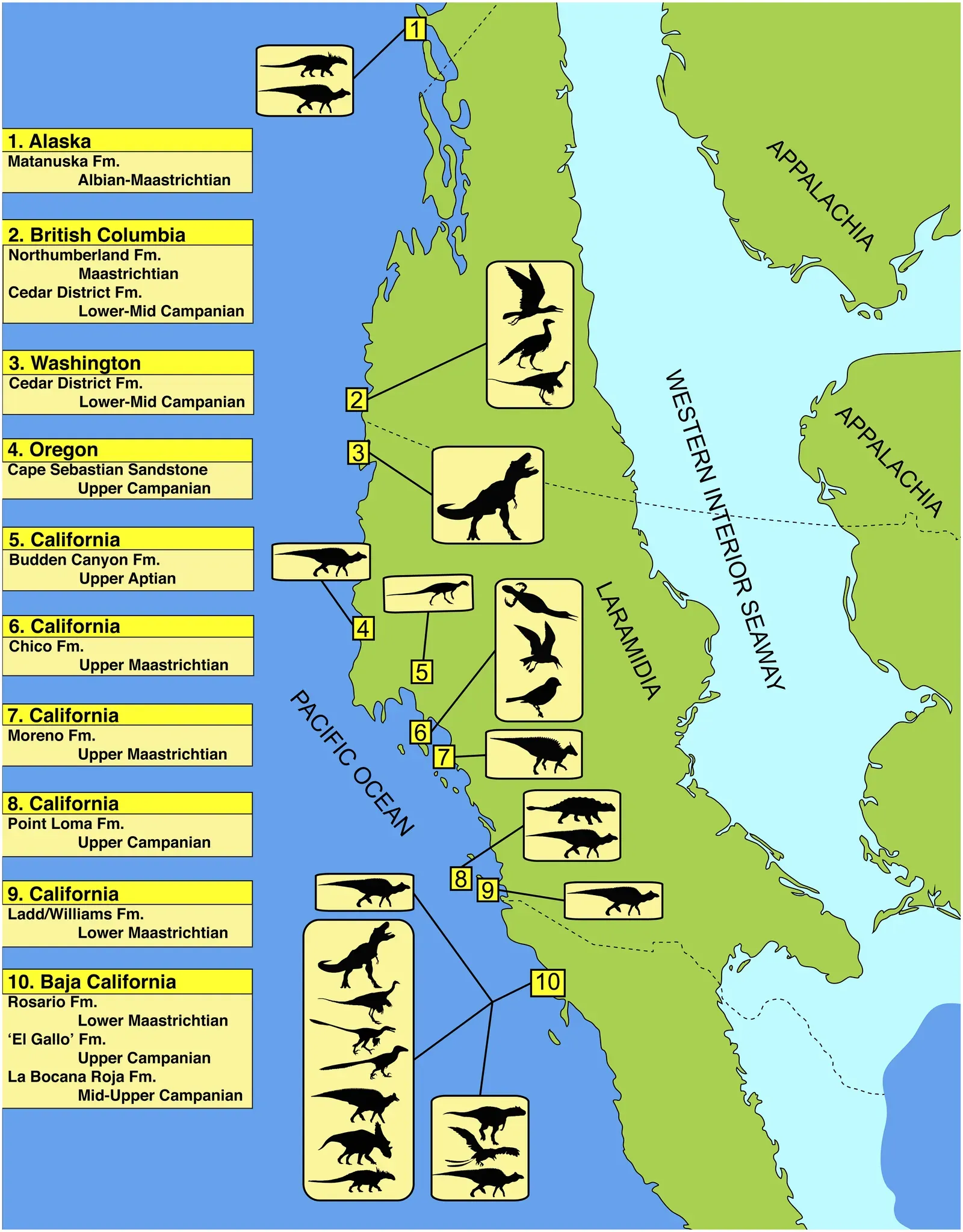
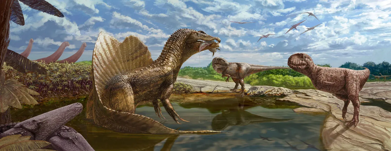
Laramidia was an island continent that existed during the Late Cretaceous period, when the Western Interior Seaway split the continent of North America in two. If you’ve ever seen a dinosaur skeleton in a museum, chances are it came from Laramidia. This narrow strip of land running from Alaska to Mexico became one of the richest dinosaur habitats ever. Geological conditions were generally favorable for the preservation of fossils in Laramidia, making the western United States one of the most productive fossil regions in the world.
In Laramidia, the Rocky Mountains were uplifting, creating lots of sediment that washed into huge alluvial plains along the Western Interior Seaway, and this was an area with high rates of sediment deposition, which was ideal for fossil formation. Dead dinosaurs washing downstream got buried quickly, preserved before scavengers could scatter the bones. The hadrosaurs, the so-called duck-billed dinosaurs, showed a staggering variety of forms in Laramidia. But it wasn’t just hadrosaurs. Tyrannosaurs, horned ceratopsians, dome-headed pachycephalosaurs, and armored ankylosaurs all thrived here.
Appalachia: The Forgotten Eastern Landmass
While Laramidia gets the spotlight, the eastern half of North America formed Appalachia, an island land mass separated from Laramidia for nearly 40 million years due to tectonism and sea-level fluctuations. Honestly, we know far less about Appalachian dinosaurs, and for good reason. By the late Cretaceous, the now ancient Appalachian Mountains were eroding away, which makes fossil formation almost impossible.
The only areas that were building up sediments were narrow flood plains very close to the Atlantic Ocean, where carcasses could float down estuaries and out to sea, being battered by the ocean and nibbled on by sharks, with little pieces falling to the ocean bottom in lag deposits that would eventually be buried by sediments. What fossils we do find are fragmentary, isolated teeth and bones mixed with marine sediments. Its fauna was isolated, and developed very differently from the tyrannosaur, ceratopsian, hadrosaurid, pachycephalosaur and ankylosaurid dominated fauna of Laramidia. Nodosaurs, those club-tailed armored dinosaurs, were far more common in Appalachia than out west.
The Laramide Orogeny and Mountain-Building Events
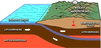
The Laramide orogeny was a time period of mountain building in western North America, which started in the Late Cretaceous, 80 to 70 million years ago, and ended 55 to 35 million years ago. Mountains rose where plains once stretched. The orogeny is commonly attributed to events off the west coast of North America, where the Kula and Farallon Plates were sliding under the North American Plate. But here’s the strange part: most mountains form near plate boundaries, yet the Rockies rose deep within the continental interior, over a thousand kilometers from the subduction zone.
A marked increase in North American dinosaur biodiversity can be attributed to dynamic orogenic episodes, with detailed fossil occurrences documenting an association between the shift from Sevier-style, latitudinally arrayed basins to smaller Laramide-style, longitudinally arrayed basins and a well substantiated decreased geographic range and increased taxonomic diversity of megaherbivorous dinosaur species. Translation? Mountain building created isolated pockets where dinosaurs evolved into unique species. According to paleontologist Thomas M. Lehman, the Laramide orogeny triggered the most dramatic event that affected Late Cretaceous dinosaur communities in North America prior to their extinction.
How Mountains Created Dinosaur Diversity Hotspots
Mountains don’t just sit there looking pretty. They reshape climates, redirect rivers, and isolate populations. Plant communities have been shown to be sensitive to subtle changes in altitude, rainfall, and humidity, and the climatic changes occurring as a result of orogenic uplift and basin segregation may have occurred sufficiently fast enough to outpace plants from crossing these barriers, altering ecosystems substantially enough to create isolated biomes.
The shift to smaller Laramide-style basins and rapid diversification events within restricted basins, with isolation events contemporaneous with known tectonic activity in the region, demonstrate that the nearly identical biogeographic histories of Ceratopsidae and Hadrosauridae are attributable to mountain building. Think about it. You’ve got related species of horned dinosaurs and duck-bills living just a few hundred kilometers apart but separated by newly formed mountain ranges. They can’t interbreed. They adapt to local conditions. New species emerge. The spectacular fossil fauna and flora preserved in the Upper Cretaceous terrestrial strata of North America’s Western Interior Basin record an exceptional peak in the diversification of fossil vertebrates in the Campanian, which has been termed the zenith of dinosaur diversity.
The Final Act: Seaway Retreat and Dinosaur Reunification
Eventually, all good things come to an end. Near the end of the Cretaceous, the Western Interior Seaway began to withdraw, resulting in both halves of North America reuniting, and as the seaway withdrew, a coastal plain expanded southward, with powerful geologic forces beginning to fold and distort the rocks of Idaho, Utah, and Wyoming, beginning the processes that would form the Rocky Mountains. The seaway drained away as the land rose, reconnecting the two isolated landmasses.
As the Western Interior Seaway retreated in the Maastrichtian, Laramidia and Appalachia eventually connected. Dinosaurs that had been evolving separately for tens of millions of years could finally meet. Western tyrannosaurs encountered eastern species they’d never seen. But this reunion was short-lived. The end of the Cretaceous is famously marked by a major extinction that killed off all dinosaurs except birds, and this extinction is attributed to an impact in the Yucatan. Just when the continent finally came back together, the curtain fell on the Age of Dinosaurs.
Conclusion
Geology wasn’t just the backdrop for dinosaurs. It was the architect of their world, the sculptor of their evolution, and ultimately, part of their downfall. From the towering peaks formed by continental collisions to the shallow seas that split North America in two, every geological event shaped where dinosaurs lived, what they ate, and how they evolved. The Laramide Orogeny carved out isolated basins that became crucibles of diversity. The Western Interior Seaway created two parallel worlds of evolution.
When you look at a dinosaur fossil, you’re not just seeing an ancient animal. You’re seeing the product of continental drift, mountain building, and ocean invasions that unfolded over hundreds of millions of years. So next time you picture a T. rex stalking its prey, remember: the ground beneath its feet had a story all its own. What do you think would have happened if Pangaea never broke apart?