America is often thought of as a young country. Two hundred and fifty years of national history, a few centuries of colonial records, and then… what? Silence? Not even close. Beneath the soil of this continent lie secrets that predate Columbus by thousands of years, and some of them are so puzzling that even the sharpest scientific minds of 2026 haven’t been able to crack them.
You might be surprised to learn that US history doesn’t start with the Declaration of Independence in 1776, but millions of years before that, with a host of discovered artifacts and ancient ruins leaving us with far more questions than answers. From giant earthen mounds in Illinois to mysterious geoglyphs scratched into the California desert, is packed with ancient enigmas that deserve far more attention than they get. Let’s dive in.
1. Cahokia Mounds, Illinois: The Vanished Metropolis
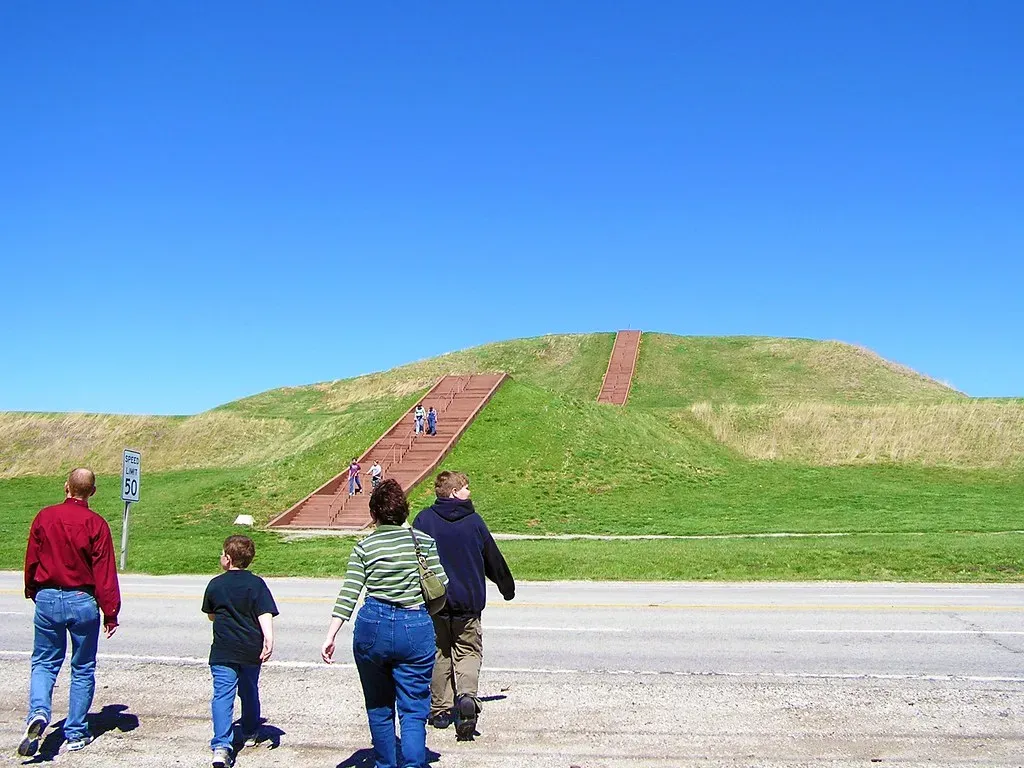
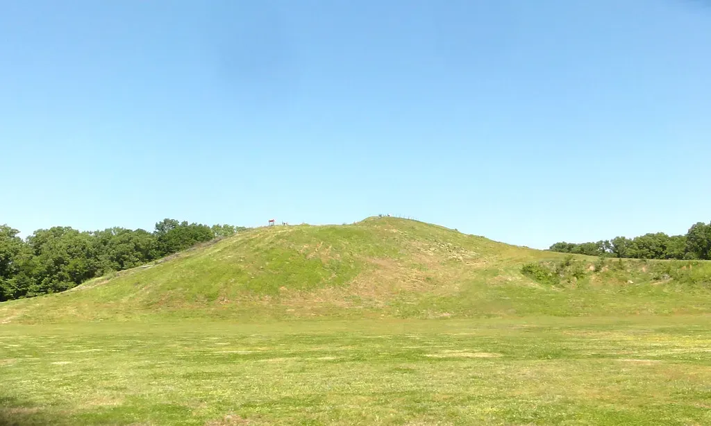
Imagine a city larger than London once stood right in the heart of North America. That’s not a metaphor or an exaggeration. Cahokia was first occupied in 700 CE and flourished for approximately four centuries, reaching a peak population of as many as 20,000 individuals, making it the most extensive urban center in prehistoric America north of Mexico. Think about that for a second. A thriving metropolis, complete with plazas, neighborhoods, and towering earthen pyramids, rising up from the Illinois floodplain long before European settlers even dreamed of crossing the Atlantic.
Among the largest features at Cahokia are an enormous central plaza encompassing nearly 40 acres and the pyramidal Monks Mound, built between 900 and 1200 CE, which rises to 100 feet, covers more than 14 acres, and contains more than 25 million cubic feet of earth. So who were these people, and where did they go? Archaeologists continue to be puzzled by the fact that there are no legends, records, or mention of this once-grand city in the lore of neighboring tribes, including the Osage, Omaha, Ponca, and Quapaw. This strange silence has led some experts to theorize that something particularly dreadful happened at the site, something the surrounding tribes wished to forget. Honestly, that alone gives you chills.
2. Chaco Canyon, New Mexico: Roads That Led Nowhere
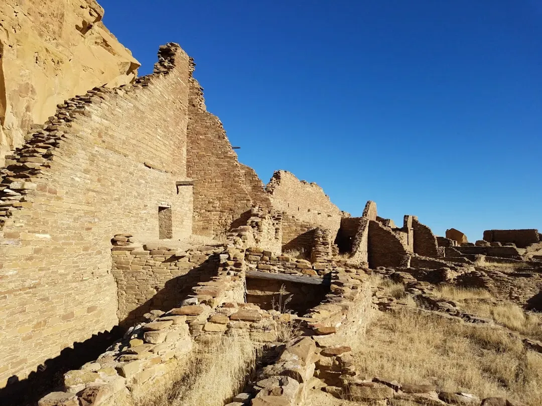
Since the discovery of the prehistoric ruins of Chaco Canyon, New Mexico, their purpose has baffled archaeologists. Research challenges the long-held assumption that Chaco was a center of trade and instead reveals evidence of brilliant astronomy by the ancient Pueblo people. Here’s the thing – you might picture ancient roads as simple dirt paths, but what you’d find at Chaco is something far more deliberate and deeply strange. Workers carved these roads into the sandstone bedrock, reaching widths of up to 30 feet, an impractical size for a society that had no wheeled vehicles or pack animals.
Researchers have found a sacred road system near Chaco Canyon in New Mexico, revealing the cosmological and spiritual significance of these ancient pathways. A team from Dartmouth College used advanced lidar technology to identify roads running parallel to each other at the Gasco site, pointing to these roads being built for Indigenous rituals, not transportation, with the paths appearing to align with significant celestial events. You’re not just looking at a road. You’re looking at a monument to the sky. Landscape, directions, the sun and moon, and the movement of shadow and light were used by the Chacoan builders to connect with a cosmic order, and while the Chacoans left no written text, their thoughts are preserved in their works.
3. The Lost Colony of Roanoke, North Carolina: CROATOAN
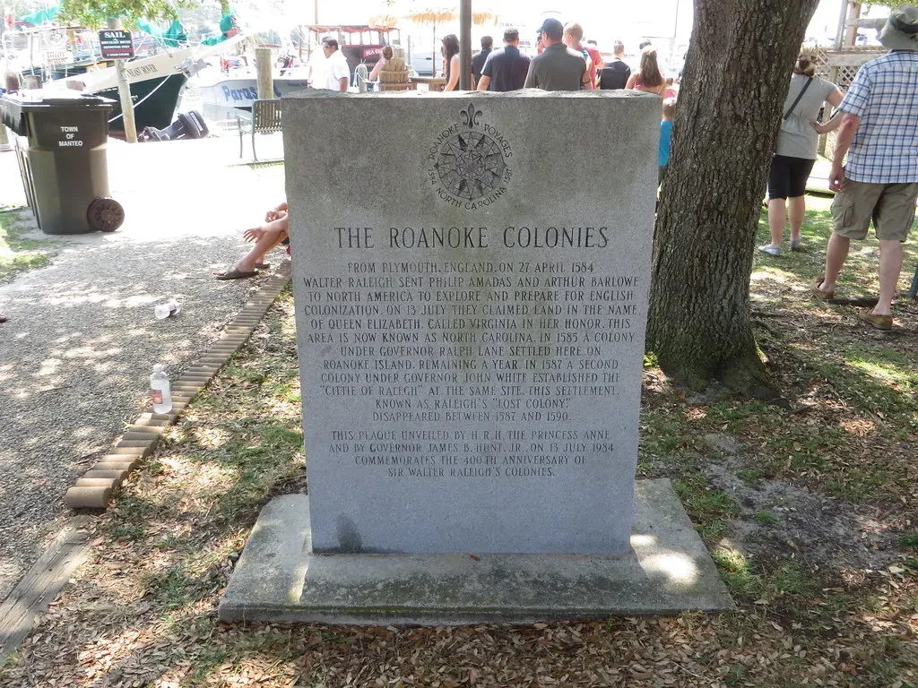
In 1587, 117 men, women, and children settled on Roanoke Island in North Carolina. Three years later, every single one of them had vanished. In 1587, English settlers established a colony on Roanoke Island in North Carolina, but by 1590, all traces of the settlement had mysteriously disappeared. The only clue left behind was the word “Croatoan” carved into a post, which could refer to a Native American tribe or an island off the North Carolina coast. That carved word has haunted historians for over four centuries.
Some documents suggest Chief Powhatan killed some of the colonists, but there is no archaeological evidence to back that up. Other theories propose the residents were attacked by the Spanish or that the colonists simply died of natural causes. The discovery of English pottery thought to belong to the colonists at a nearby site offered a clue as to the fate of those 115 men, women, and children, but the truth remains elusive more than 430 years later. I think what makes this mystery so emotionally powerful is the image of an entire community simply erased, as though the earth swallowed them whole.
4. Mystery Hill (America’s Stonehenge), New Hampshire: Who Really Built It?
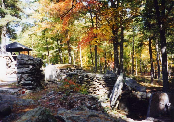
Although locals sometimes call it “America’s Stonehenge,” Mystery Hill bears little resemblance to the English megalith. Instead, it is a complex of stone structures and artificial caves, most likely only as old as the 17th century. However, exact dating may never be possible, as the ruins suffered from tampering at the hands of a 1930s landowner who was convinced the structures were the remains of a 7th-century Irish monastic colony. The tragic irony? His enthusiastic “fixing” of the site may have permanently destroyed the evidence needed to solve it.
It may not be as mighty as England’s famous stone circle, but America’s Stonehenge is equally shrouded in mystery, and nobody really knows who constructed the manmade chambers, walls, and ceremonial meeting places. Parts of the site have been carbon-dated to 4,000 years ago, while the stone chambers and walls are more reminiscent of early American settlers in the 1700s. There are supposedly Phoenician, Iberian Punic, and Ogham inscriptions, although some think these could have been left by later Indigenous peoples or be colonial graffiti. It’s a site where every answer spawns three more questions, and the timeline feels genuinely scrambled.
5. The Great Serpent Mound, Ohio: The Cosmic Snake
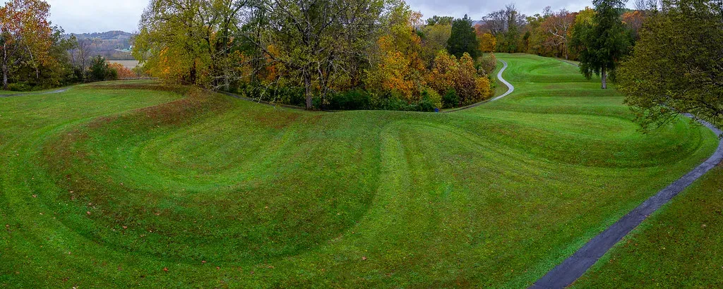
You have to see this one from the air to truly grasp it. Great Serpent Mound is more than 1,300 feet long, 20 to 25 feet wide, and protrudes from a grassy ridge by up to three feet, making it the world’s largest serpent effigy. It winds across a plateau in a snake-like shape and is believed to have been constructed by Indigenous Ohioans, yet archaeologists haven’t been able to specify the culture or date, with estimates varying from 321 BC to AD 1070. That’s nearly fourteen centuries of uncertainty – a margin so wide it’s almost hard to believe.
Archaeologists haven’t been able to pinpoint a specific culture or explain why it was constructed, with estimates varying from 321 BC to AD 1070. There are also three burial mounds nearby, two created by the Adena culture between 800 BC and AD 100 and one by the Fort Ancient culture from AD 1000 to 1650. The serpent design itself is hauntingly precise, elegantly coiled, with what appears to be an egg or oval shape in its open mouth. Was it a celestial map? A ceremonial effigy? A spiritual marker? No one really knows, and that mystery makes it one of the most visually arresting ancient sites anywhere in the world.
6. Casa Grande Ruins, Arizona: The Four-Story Enigma
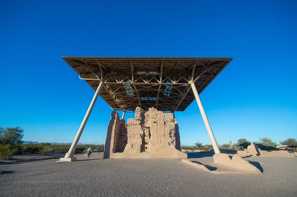
Rising out of the flat Arizona desert like some ancient ghost tower, Casa Grande has baffled every expert who has ever laid eyes on it. Archaeologists understand some things about Casa Grande in Arizona: they know it was probably constructed in the early 13th century, that the builders used adobe, and that the full complex included several other adobe structures and a ball court, once surrounded by a wall. What they still don’t know is what the four-story central building was actually for: a guard tower, a grain silo, a house of worship, or something else entirely.
The site was abandoned nearly half a century before Columbus’s voyage to the Americas, long after the nearby Hopi had moved away, and was too ruined for early Spanish explorers to do their own investigating into what it had been. Today, the main building is under a protective roof built by Civil Conservation Corps workers in the 1930s, and the historical ruins are a federally protected national park, making this the first prehistoric ruin to become a park in . The structure itself is imposing and oddly beautiful, a four-story adobe giant standing in quiet defiance of everything we think we know.
7. The Blythe Intaglios, California: Desert Giants From Above
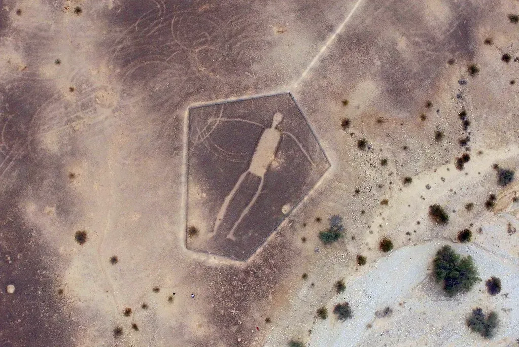
Peru has its Nazca Lines, and California has its own version. Let’s be real, the Blythe Intaglios are just as jaw-dropping, and far fewer people have even heard of them. The Blythe Intaglios are like an American version of Peru’s Nazca Lines. The oversized figures, the largest of which is 171 feet long, were probably created between 450 and 2,000 years ago and are generally credited to the Mojave and the Quechan. The geoglyphs were only discovered in the 1930s by a pilot flying overhead, and their purpose remains unknown. They may be connected to sacred ceremonial dances once held in the area or could even be ancient star maps.
Researchers believe the local Mojave people were the likely creators of the site. However, as with the Nazca Lines, they can’t explain how the Mojave would have seen them from their intended aerial view, or what purpose they actually served. That’s the part that gets me every time. These enormous human figures and animals were clearly meant to be seen from high above. They were created by people with no aircraft, no satellite imagery, and no drone cameras. Yet the scale and precision suggest an intentional design meant for a vantage point the creators could never physically reach. The dedication required to build something you’ll never see properly is extraordinary.
8. Poverty Point, Louisiana: Engineering the Impossible
Here is a site that the academic world is still struggling to fully explain. Poverty Point is a massive network of earthwork construction. The network includes mounds, concentric ridges, and a central plaza. It is believed to have been constructed by Native Americans who inhabited the lower portion of the Mississippi Valley between 1100 and 1700 BC. However, the purpose is not clear, and archaeologists suggest they were used as settlements, a trading center, or a ceremonial and religious center.
Rising from Louisiana’s landscape, the Poverty Point Mounds represent one of North America’s most sophisticated ancient construction projects. The site’s precise geometric design and enormous scale required advanced engineering knowledge that seemed impossible for its time period. Archaeological studies suggest it was an ancient residential, trade, and ceremonial center, but researchers still aren’t fully certain why this sophisticated earthwork complex was constructed. It’s thought Poverty Point was abandoned sometime around 1100 BC, and another Indigenous group moved in for a brief period around AD 700. For a civilization without metal tools or beasts of burden, what was built here is nothing short of staggering.
9. Judaculla Rock, North Carolina: The Endless Billboard
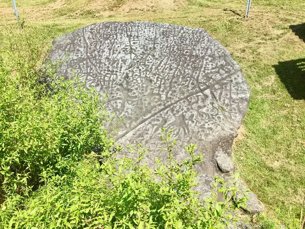
Think of it as the ancient world’s equivalent of a message board, except nobody can agree on what the messages say. For years, the Cherokee people who lived near the soapstone boulder now known as Judaculla Rock used it as a sort of billboard, etching so many petroglyph designs into the North Carolina stone that even today it’s difficult to tell exactly how many there are. The boulder also sports seven grooves, described as the mythical footprints of a legendary giant, which contemporary archaeologists attribute to ancient masons mining the soapstone to make bowls. Research has been slow because soapstone is naturally fragile, and the Cherokee also still see the rock as a sacred artifact.
This soapstone boulder was once a sacred site for the Cherokee people, who believed that an ancient giant creature called Judaculla landed here when jumping from one mountain to another. Carvings of stick figures, claw marks, and winged shapes are etched into the rock, which archaeologists have dated to between 2000 and 200 BC. The carvings are layered so densely on top of one another that it’s nearly impossible to determine which images were added first or what the original message was supposed to be. It’s like reading a palimpsest in stone, where every generation added its own voice without erasing what came before.
10. White Sands Footprints, New Mexico: Rewriting Human History
If you thought you understood when humans first arrived in North America, prepare to be surprised. The discovery of fossilized footprints in White Sands National Park offered evidence that humans roamed North America 21,000 to 23,000 years ago, much earlier than previously thought. However, the findings of the original 2021 study were disputed by a second study in 2022, which claimed the footprints were just 15,000 to 13,000 years old. A third study in 2023 reaffirmed the original findings. The confusion all came down to the dating techniques used, which are still up for debate in some scientific circles.
Research on the fossilized footprints revealed them to be possibly 21,000 to 23,000 years old, meaning they predate the park’s signature gypsum dunes and represent some of the oldest known human footprints in North America. Covering around a mile, it’s also the longest track of fossilized human footprints ever discovered. They were made mostly by children and teenagers, including one child under three, and other prints show that these people crossed paths with mammoths and giant sloths. Pause on that image for a moment. A toddler leaving a footprint in soft mud, wandering through a landscape shared with woolly mammoths, and that tiny impression surviving in the earth for more than 20,000 years. It’s one of the most emotionally resonant archaeological finds this country has ever produced.
Conclusion
What’s remarkable about all ten of these sites is that they refuse to be neatly packaged. Instead of the Great Wall of China or Stonehenge, these are all ancient American ruins and landmarks. is a relative newcomer to the world stage, but there have been people long living on this continent, and they have left traces of their presence just as mysterious as those found in other countries. Each of these mysteries is a doorway into a world we barely understand, a reminder that the story of humanity on this land runs far deeper than most people realize.
You don’t need to travel to Egypt or Peru to stand in the presence of the ancient and unexplained. You can drive to Illinois, walk through a New Mexico park, or hike into the Arizona desert and find questions that have outlasted every civilization that tried to answer them. Maybe that’s the real gift of archaeology: not the answers it delivers, but the sense of wonder it keeps alive. Which of these mysteries would you most want to investigate? Tell us in the comments below.