If you want to feel the weight of deep time in your bones, you do not need a textbook or a lab coat – you just need the right landscapes. Across the United States, a handful of places quietly hold chapters of Earth’s story that stretch back more than a billion years, from ancient seas and colliding continents to roaring volcanoes and grinding ice. When you stand in front of these rocks, you are not just sightseeing; you are looking straight into the planet’s memory.
In this guide, you are going to travel – at least in your imagination – from the bottom of the Grand Canyon to the steaming basins of Yellowstone and the fossil-rich hills of South Dakota. At each stop, you will see how a particular cliff, canyon, dome, or reef freezes one moment in a very long story. By the end, you will have a mental map of Earth history written not in charts but in cliffs, lava, sand, and stone. And you may find yourself planning a very different kind of road trip.
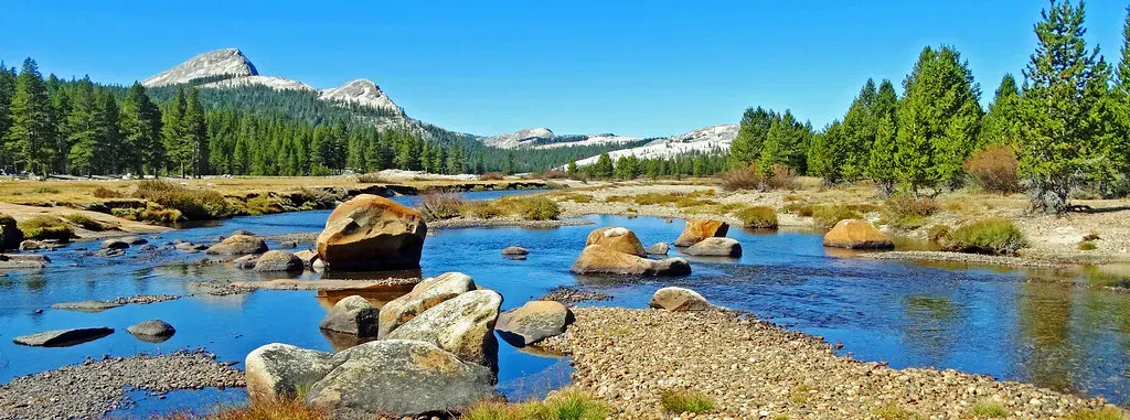
1. Grand Canyon, Arizona: A Vertical Timeline Nearly Two Billion Years Deep
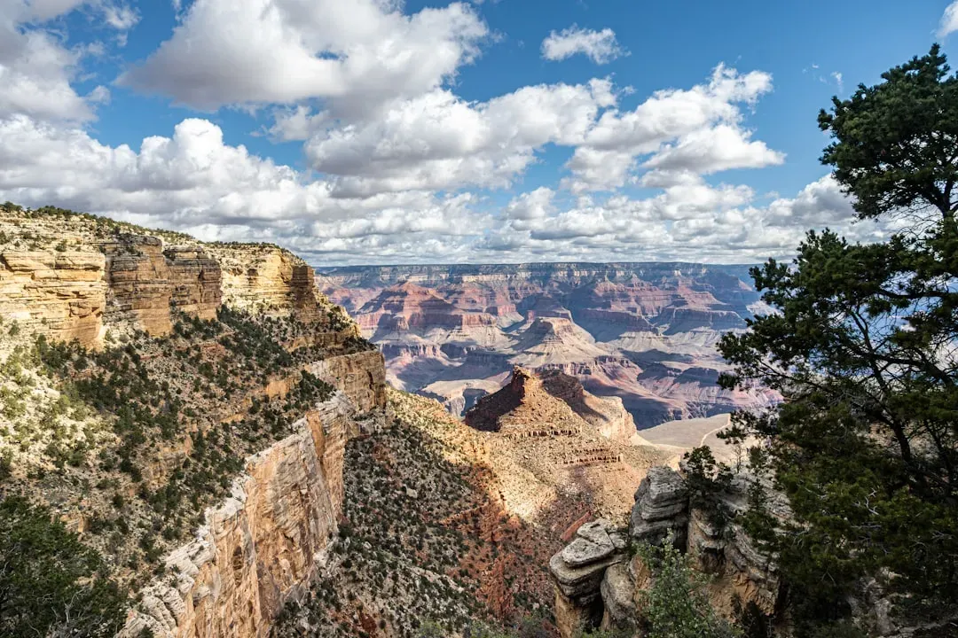
When you walk to the rim of the Grand Canyon and look down, you are staring into a rock record that spans roughly from about 1.8 billion years ago to around 270 million years ago. At the very bottom, the dark, highly deformed rocks of the Vishnu Basement complex represent some of the oldest known rocks in the region, formed when early continental crust was being reshaped under intense heat and pressure. Higher up, flat-lying sedimentary layers record long-lost beaches, river plains, coastal swamps, and warm seas laid down over immense spans of time.
What makes the canyon so powerful for you as a visitor is not just the age of the rocks but how clearly you can see their relationships. You can trace sharp boundaries called unconformities where whole chapters of time are missing, eroded away before younger layers were stacked on top. As you follow the strata with your eyes from layer to layer – the ancient Vishnu rocks, then tilted Grand Canyon Supergroup sediments, then the horizontal Paleozoic “staircase” – you effectively watch North America evolve from a developing crustal block to a shallow tropical sea teeming with early marine life. It is one of the clearest places on Earth to physically see that deep time is real, not just an abstract idea.
2. Yosemite Valley, California: Granite, Glaciers, and the Birth of a Mountain Range
In Yosemite Valley, you are surrounded by enormous walls of pale, crystalline rock – mostly granitic varieties that solidified from magma deep underground during the age of the dinosaurs. These rocks belong to a huge body called the Sierra Nevada batholith, which formed as an ancient subduction zone fed magma into the crust over tens of millions of years. Later uplift and erosion stripped away the overlying rocks, exposing the once-buried granites as towering cliffs like Half Dome and El Capitan.
Fast forward to the relatively recent geologic past, and glaciers carve the valley into its iconic U-shaped profile. As thick ice moved through the canyon, it quarried slabs from the granite walls, smoothed surfaces, and steepened cliffs, leaving behind hanging valleys and polished domes. When you stand on Glacier Point or hike toward Half Dome today, you are seeing two stories at once: a deep-time tale of magma chambers and continental growth, and a much younger chapter where ice sculpted the raw granite into a dramatic, camera-ready landscape.
3. Rocky Mountain National Park, Colorado: Ancient Crust Lifted Toward the Sky
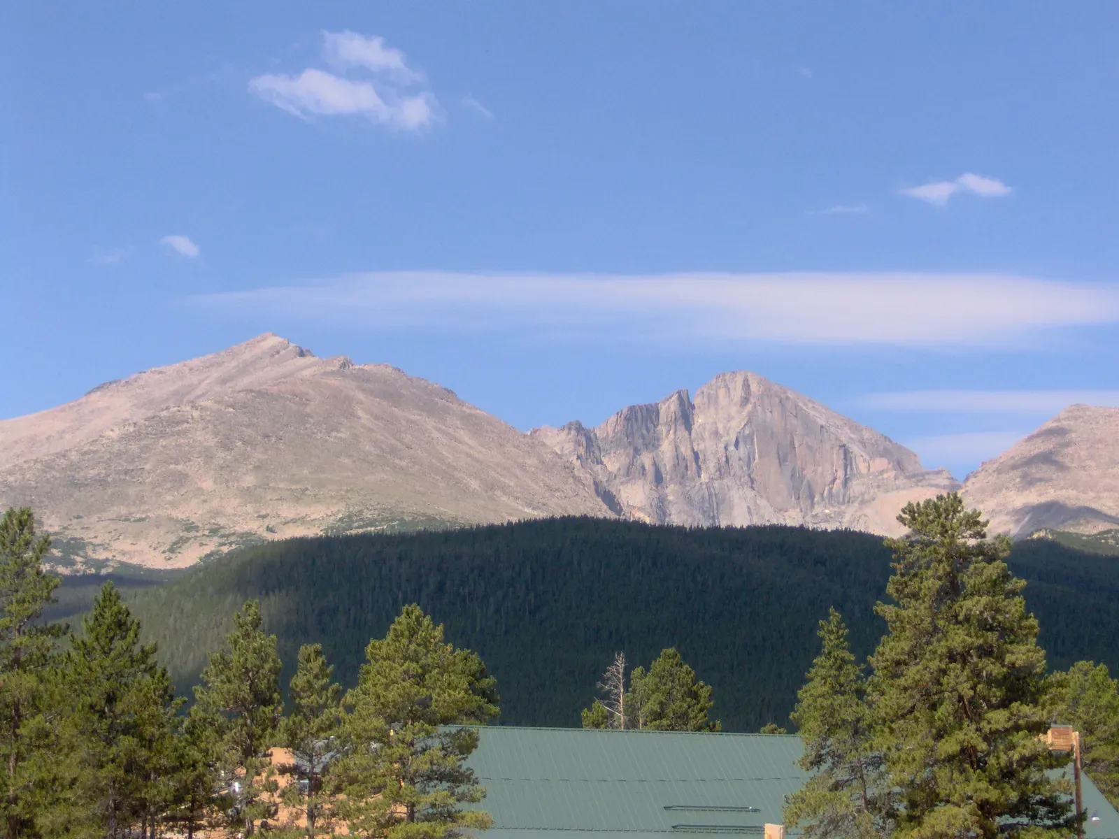
In Rocky Mountain National Park, you walk on some of the oldest rocks in the continental interior, yet you are standing on peaks that only rose to their modern heights relatively recently in geologic terms. Much of the park’s core consists of ancient crystalline rocks – granites and metamorphic gneisses – that formed over a billion years ago deep within the crust. These rocks slept at depth for ages, later overlain by younger sedimentary layers.
Then, starting roughly around seventy million years ago, crustal blocks began to heave upward during what geologists call the Laramide orogeny. That uplift bent and fractured the crust, pushing old basement rocks toward the surface to become high peaks like Longs Peak. Glaciers later carved cirques, horns, and U-shaped valleys into those uplifted blocks. When you drive Trail Ridge Road or hike across alpine tundra, you are literally walking on once-buried basement rock that was hoisted upward and then scraped by ice, turning deep crust into skyline.
4. Yellowstone, Wyoming: A Restless Hotspot Above a Growing Supervolcano
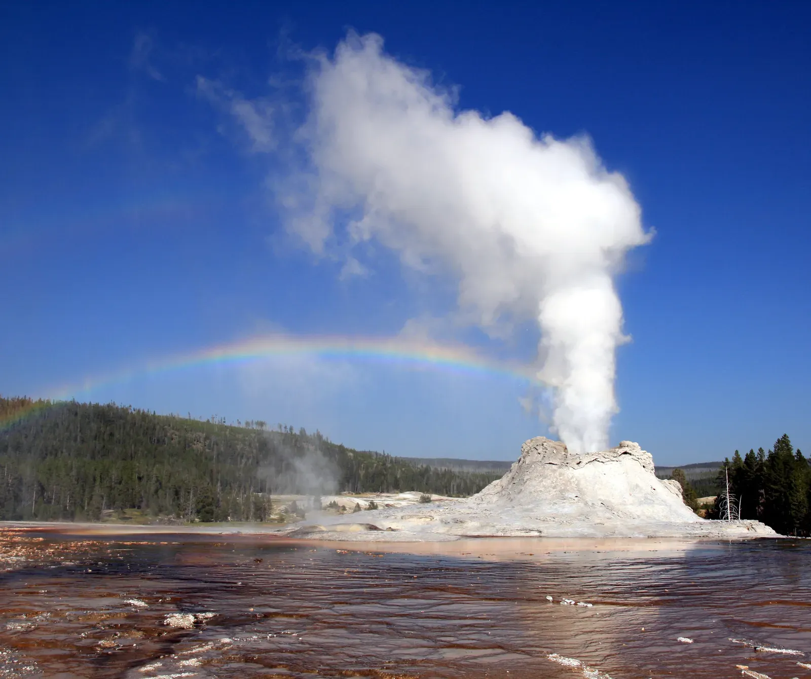
Yellowstone lets you see planetary heat in action. Beneath your feet lies a powerful mantle hotspot that has fueled enormous volcanic eruptions over the last few million years. Three exceptionally large explosive eruptions created huge calderas and spread ash across much of North America, while smaller eruptions and lava flows continued to reshape the region. The result for you is a landscape full of volcanic plateaus, obsidian-rich lava, and hydrothermal activity that hints at heat still rising from below.
When you watch Old Faithful erupt or walk past a boiling mud pot, you are seeing groundwater interacting with this lingering magmatic heat in the shallow crust. Hot, mineral-rich fluids alter the surrounding rocks, depositing colorful silica and sulfur around vents and springs. If you look beyond the tourist boardwalks, you can see how repeated eruptions, faulting, and uplift have produced a high plateau scarred by collapsed calderas and cut by river canyons. It is a reminder that Earth is not a finished product; in Yellowstone, the story is still being written.
5. Devils Tower, Wyoming: Frozen Magma and Giant Stone Columns
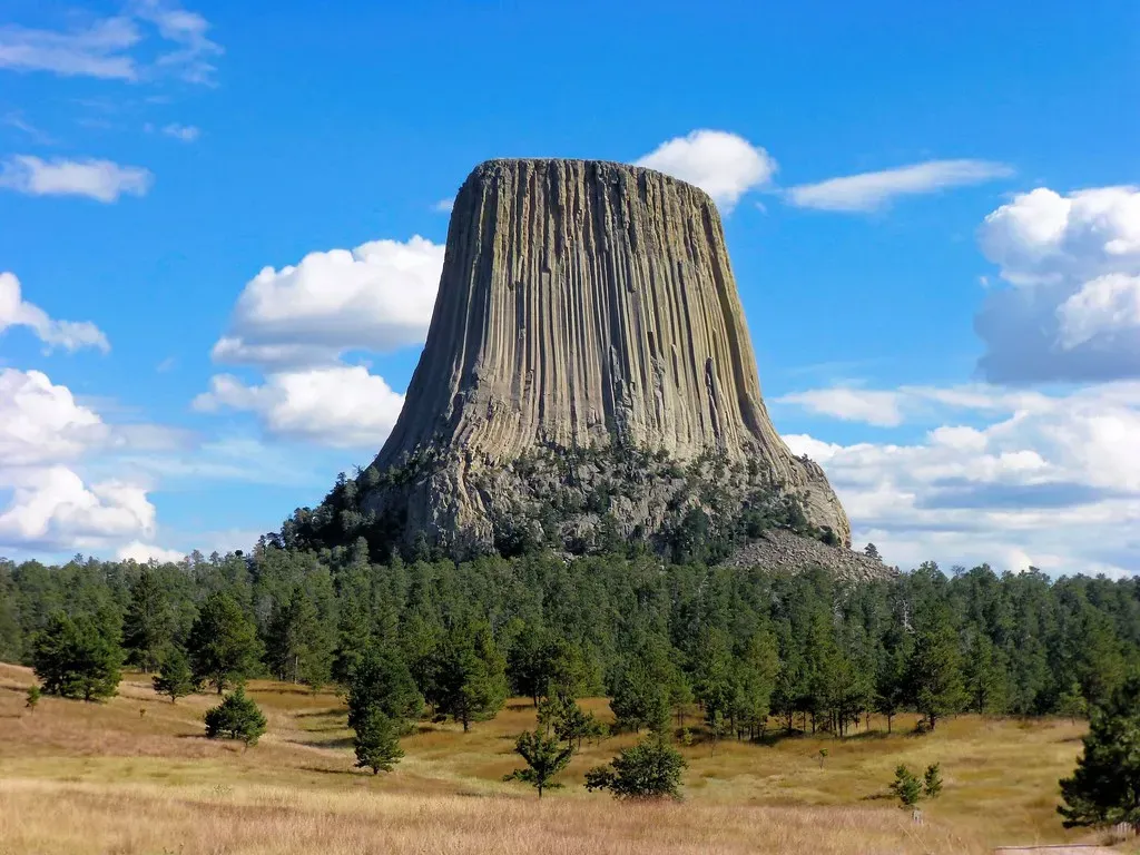
Devils Tower rises abruptly from the surrounding landscape, a solitary pillar of igneous rock that gives you a textbook look at how magma can solidify underground. Most evidence points to the Tower being either the core of an ancient volcanic conduit or a shallow intrusion that never quite made it to the surface as a full eruption. As the molten rock cooled slowly, it cracked into tall, hexagon-like columns in a pattern called columnar jointing, which forms when cooling and contraction create regularly spaced fractures.
Over millions of years, the softer surrounding sedimentary rocks eroded away, leaving the harder igneous core standing high above the plains. When you walk the loop trail at the base, you can see fallen columns piled as talus and look up at vertical joints running the full height of the monolith. It is like seeing the internal plumbing of an ancient volcano stripped bare, with gravity and weather having done the excavation work for you.
6. Badlands National Park, South Dakota: Eroding Hills That Reveal an Age of Mammals
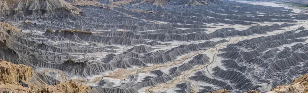
Unlike many sites that show you ancient seas or deep crust, the Badlands open a window into a much younger chapter: the age after the dinosaurs, when mammals were diversifying across North America. The colorful, banded hills and spires are made of sedimentary rocks and volcanic ash layers deposited during the last few tens of millions of years. They include river and floodplain deposits that once supported early horses, rhinos, and other now-extinct animals whose fossils you can still find in the layers.
What makes the Badlands so compelling for you is how quickly they are changing. Soft rock erodes fast in this semi-arid climate, creating sharp ridges, gullies, and intricate patterns that can visibly shift over a human lifetime. As rain and wind carve deeper each year, new fossils are exposed in the freshly eroded slopes. When you stand on an overlook, you are seeing both a record of the relatively recent geologic past and a landscape that is actively reshaping itself in front of you.
7. Mammoth Cave, Kentucky: A Hidden Labyrinth in Ancient Seafloor Limestone
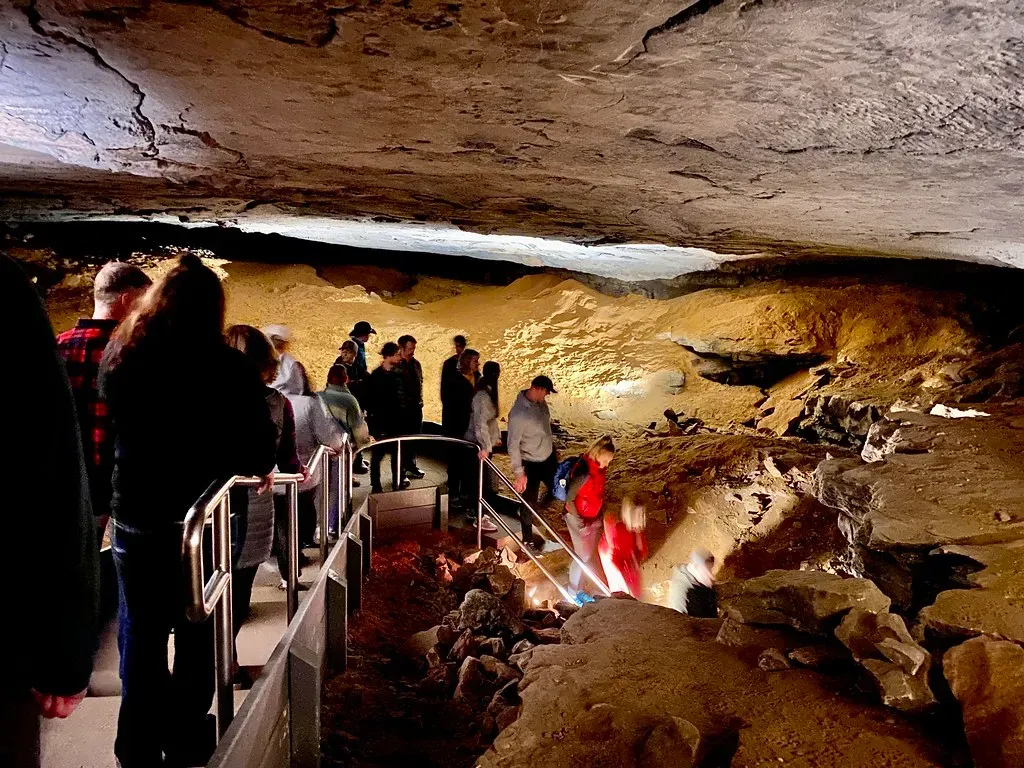
Mammoth Cave is not just a long cave system; it is the world’s longest known cave network, and it exists because of a precise match between rock type, water, and time. The cave passages are carved into thick layers of limestone that originally formed as sediments on the floor of warm, shallow seas hundreds of millions of years ago. Over time, slightly acidic groundwater seeped through fractures in the limestone, dissolving it away and enlarging cracks into tunnels and rooms.
When you explore the cave today, you move through stacked levels of passages that record changes in underground water flow as the landscape above was uplifted and rivers cut deeper valleys. You can see old, dry tunnels higher up and active, water-filled conduits at lower levels, each tied to a different stage in the region’s geologic evolution. The stalactites, stalagmites, and flowstones you admire are the slow, ongoing work of dripping mineral-rich water, quietly continuing a story that began in an ancient ocean.
8. Hawaii Volcanoes National Park, Hawaii: A Living Factory of New Oceanic Crust
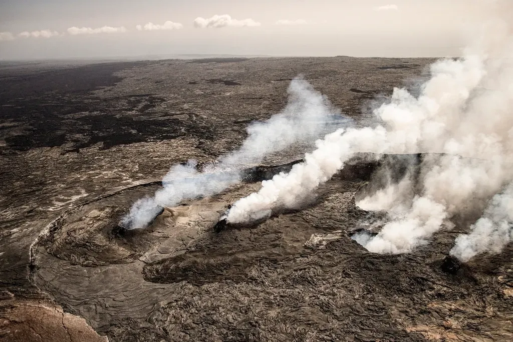
On the Island of Hawaii, you get to watch brand-new rock being born right in front of you. Like Yellowstone, Hawaii sits above a mantle hotspot, but here the activity is mostly gentle, basaltic volcanism rather than explosive caldera eruptions. Repeated outpourings of fluid lava from volcanoes such as Kīlauea and Mauna Loa build up shield-shaped mountains that rise from the seafloor to form islands. Each flow cools into fresh basalt, adding another thin layer to the growing pile.
When you walk over hardened lava fields, you can often see multiple generations of flow surfaces stacked or cross-cutting each other – smooth, ropy pahoehoe, rough aa, and collapsed lava tubes. These layers preserve snapshots of eruptions that might have happened decades or centuries apart, letting you literally step across different moments in recent geologic time. At the same time, the chain of islands and seamounts stretching northwest from Hawaii records the longer-term track of the Pacific Plate moving over the stationary hotspot, turning the Pacific Ocean into a moving canvas of volcanic history.
9. Crater Lake, Oregon: A Collapsed Volcano Filled with Remarkable Blue Water
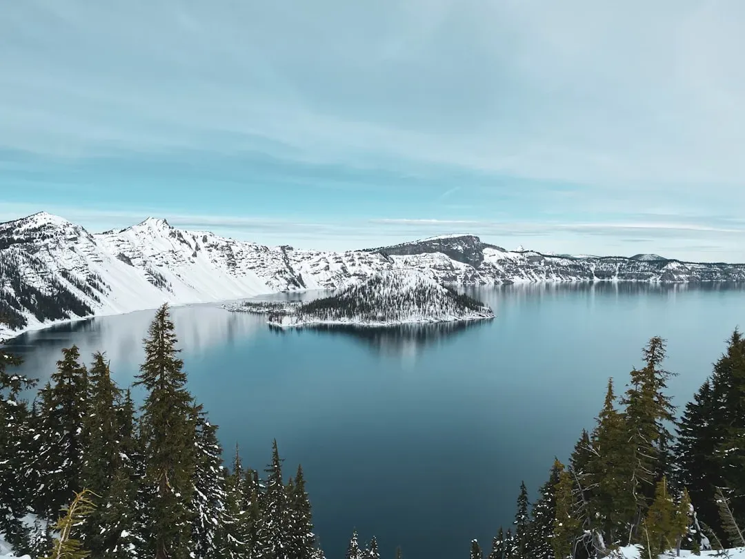
Crater Lake looks serene, but its origin story is anything but calm. Around seven to eight thousand years ago, a large stratovolcano known as Mount Mazama erupted violently, emptying much of its magma chamber in a short period. Without internal support, the summit area collapsed inward, forming a deep, steep-walled depression called a caldera. Over time, snow and rain filled the caldera, creating the strikingly deep, clear lake you see today.
As you drive the rim road or hike along the caldera edge, you can pick out remnants of the old volcanic structure – surviving peaks on the rim and Wizard Island, a younger cinder cone that rose from the caldera floor during later eruptions. Ash from Mazama’s climactic eruption can be traced across much of the Pacific Northwest, letting geologists tie distant sediments to this single event. For you, Crater Lake offers an unusually clean cross section through a large volcano, revealing what happens when a magma chamber drains so fast that the entire summit collapses.
The Guadalupe Mountains thrust abruptly out of the desert in West Texas and southeastern New Mexico, but their rock tells the story of a vanished sea. Here you are walking on the remains of a massive Permian reef system, built roughly around a quarter of a billion years ago by marine organisms along the margin of an inland basin. This ancient reef complex, known as the Capitan Reef, encircled a body of water called the Delaware Basin and was later buried beneath younger sediments.
Today, uplift and erosion have stripped away much of the overlying rock, exposing the reef as towering limestone cliffs and canyons. When you hike trails near Guadalupe Peak or explore nearby Carlsbad Caverns, you move through cross-sections of this fossil reef, seeing old reef slopes, lagoon deposits, and deep-basin sediments frozen in place. The setting feels dry and rugged now, but every ledge and wall around you is a direct reminder that this was once a thriving tropical marine ecosystem, long before dinosaurs ever appeared.
11. Glacier National Park, Montana: Ancient Sediments Carved by Modern Ice
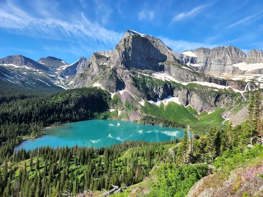
In Glacier National Park, you encounter some of the oldest relatively undeformed sedimentary rocks in North America, known as the Belt Supergroup. These rocks were laid down more than a billion years ago in an ancient inland sea or series of basins, accumulating layer after layer of mud, sand, and carbonate. Many of these layers preserve fine laminations and even early microbial structures, giving you a rare, detailed look at Earth’s environment long before complex animals evolved.
Much later, during the ice ages of the last couple of million years, thick valley glaciers sculpted this resistant rock into sharp peaks, knife-edge ridges, and deep U-shaped valleys. As you hike to places like Grinnell Glacier or stand along Going-to-the-Sun Road, you can see striations and polished surfaces where moving ice scraped across the bedrock. The contrast is striking: extremely ancient sedimentary layers wearing scars from very recent ice, stacked together into one view. It is a place where deep time and the last heartbeat of the ice age share the same skyline.
Conclusion: Reading Deep Time on Your Next Road Trip

When you step back and look at all these places together, you start to realize that the United States is like an open book of Earth history, with each park and monument offering you a different chapter. In the Grand Canyon you read a vertical stack of nearly two billion years of rock; in Yosemite and the Rockies you see how continents grow and mountains rise; in Yellowstone and Hawaii you watch heat from the deep Earth build new crust; in Mammoth Cave and the Guadalupe Mountains you explore the long-vanished seafloors that once covered the land. Badlands and Glacier add the more recent chapters, where mammals, ice, and erosion shape the surface we know today.
You do not have to memorize ages or rock names to appreciate any of this; you only need to remember that every layer and landform around you is there for a reason. On your next trip, try pausing at a canyon rim, a lava field, or a mountain pass and asking yourself what that view is telling you about time, change, and the planet’s past. Once you start seeing landscapes as stories frozen in stone, it becomes hard to look at any cliff or valley the same way again – what part of Earth’s long story do you want to stand inside next?