Our planet has been building, breaking, and reshaping itself for roughly four and a half billion years. Most of that work happens so slowly it is invisible. You cannot watch a mountain form. You cannot feel a continent drift. Yet the results of all that slow, titanic effort are scattered across the Earth in plain sight, sometimes so strange they genuinely make you question whether you are still on the same planet you grew up on.
From a desert that bleeds red in Antarctica to a salt flat so perfectly flat that NASA uses it to calibrate its satellites, the Earth has produced geological wonders that defy easy explanation. Some of them took a billion years to make. Others are still being made right now, under your feet, without you even knowing it. If you think you have seen it all, you haven’t. Let’s dive in.
The Eye of the Sahara: Earth’s Most Mysterious Bullseye
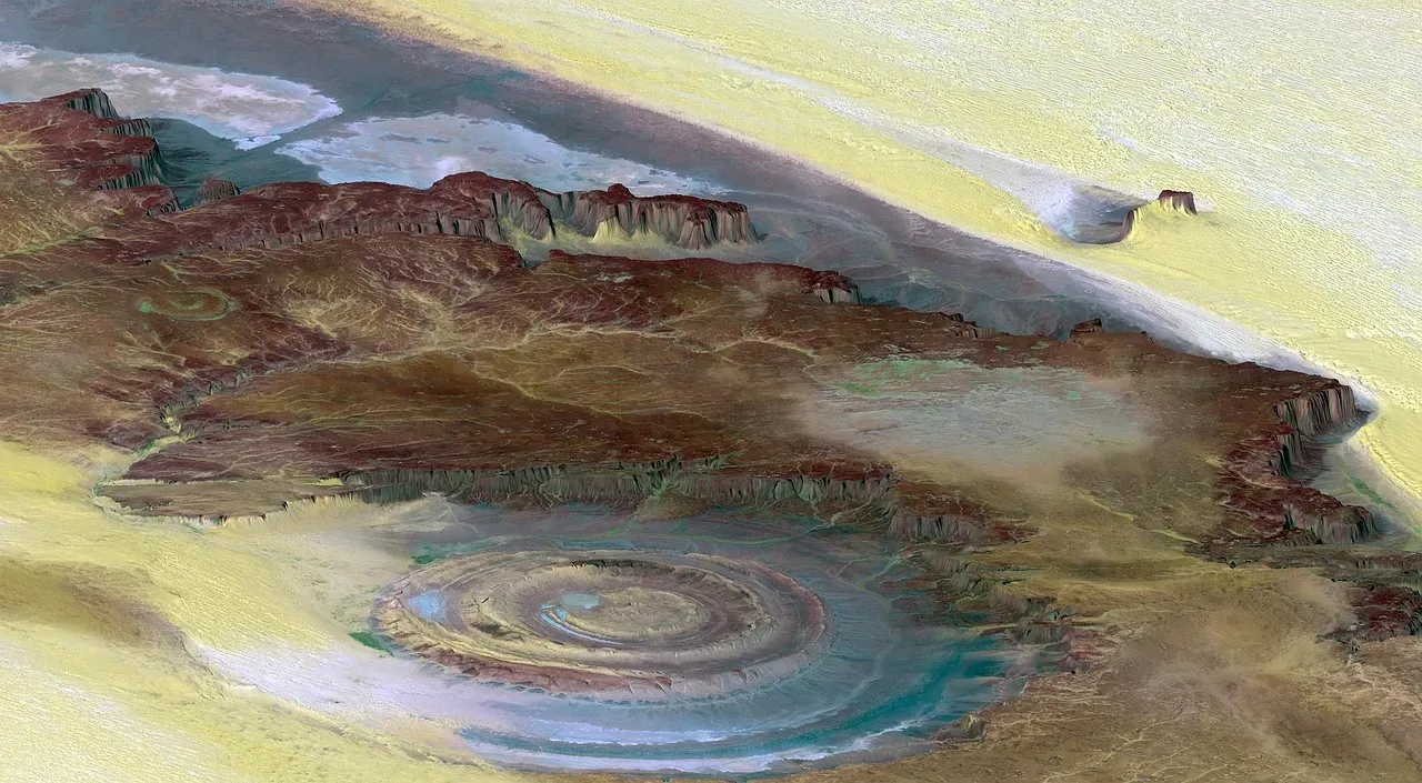
Picture yourself looking out the window of the International Space Station. Below you, the Sahara Desert stretches endlessly. Then, out of nowhere, you see it: a perfect bullseye, carved into the Earth as if a giant pressed a thumb into wet clay. In the Sahara Desert of Mauritania, a colossal series of concentric rings stretches roughly 25 miles across, known as the Richat Structure, or the “Eye of the Sahara.” The mysterious formation is large enough for early space missions to have used it as a landmark.
Geologists initially thought the site was created by an asteroid impact, but there isn’t enough melted rock among the rings to support this theory, and there’s no evidence to suggest a volcanic eruption either. The structure is now understood to be a deeply eroded geological dome. Millions of years ago, molten rock pushed upward beneath sedimentary layers without breaking through the surface, and over time, uplifted rock layers eroded at different rates, leaving the dramatic ringed pattern. Honestly, even with a scientific explanation in hand, it still looks like something deliberate. Something ancient and unknowable left its fingerprint here.
The Giant’s Causeway: Nature’s Staircase to Nowhere
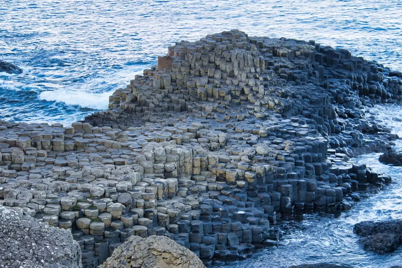
You’ve probably seen pictures of it and assumed they were digitally enhanced. They weren’t. Giant’s Causeway is a natural geological formation located in Northern Ireland that consists of over 40,000 hexagonal basalt columns, interlocked like puzzle pieces, made of cooled and hardened lava erupted from a volcanic fissure about 60 million years ago. The columns vary in height and width, with some reaching as high as 39 feet.
This process, known as columnar jointing, created interlocking pillars as the lava cooled from the top and bottom simultaneously, and over millions of years, erosion removed surrounding material, exposing the formation. Legend has it that the giant Finn McCool fashioned the Giant’s Causeway to walk across the sea to Scotland and face his great rival Benandonner. Given how impossibly geometric the whole thing looks, you almost want the legend to be true. Science has an explanation, but mythology feels just as reasonable when you’re standing at the edge of those stone steps, staring at the sea.
Salar de Uyuni: The World’s Largest Mirror
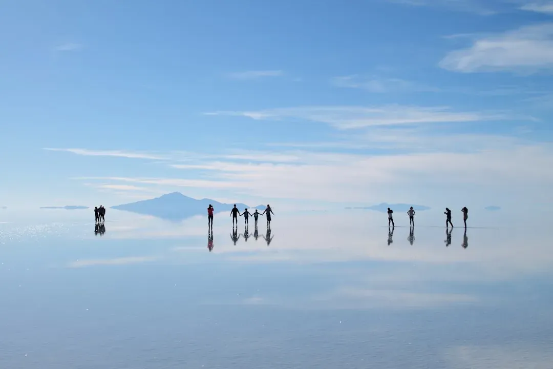
Salar de Uyuni is the largest salt flat in the world, with an area of approximately 10,582 square kilometres, situated in southwestern Bolivia near the crest of the Andes Mountains, at an elevation of nearly 12,000 feet above sea level. It was formed as a result of transformations of seven Late Pleistocene lakes whose progressive desiccation led to the accumulation of extensive evaporitic salt deposits, and is now covered by an 8-metre-thick layer of salt so flat that the average elevation varies by less than one metre over the entire area.
The large area, clear skies, and exceptional flatness of the surface make the Salar ideal for calibrating the altimeters of Earth observation satellites. When it rains, something magical happens: a thin layer of water turns the entire surface into a perfect mirror, and suddenly the line between sky and land disappears, so you can literally walk into the clouds. Below all that mesmerizing beauty, the Salar de Uyuni desert sits atop about 11 million tons of highly sought-after lithium. It is simultaneously one of the most romantic landscapes on Earth and one of its most valuable mineral reserves.
Blood Falls, Antarctica: A Glacier That Bleeds
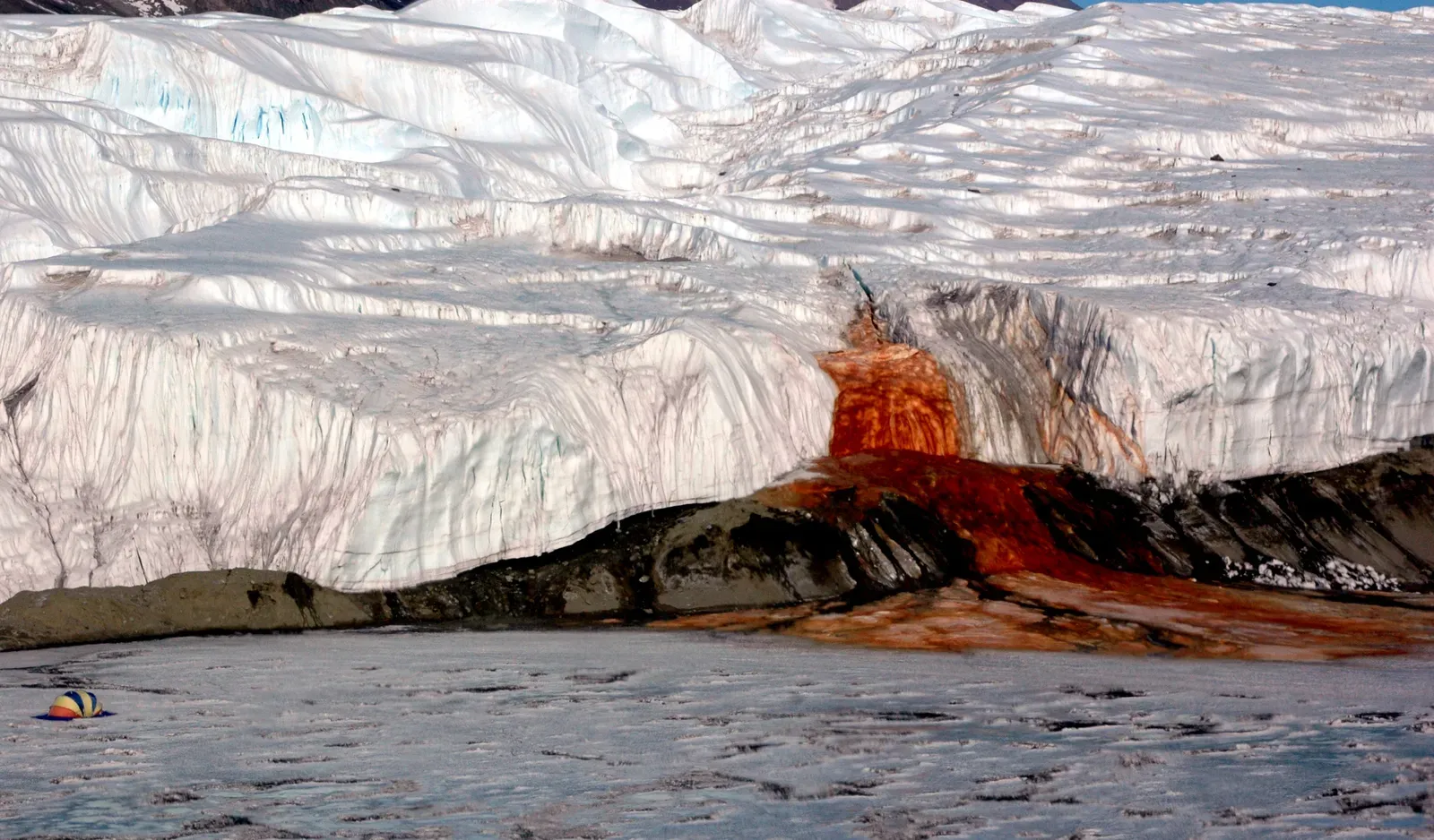
Here’s the thing about Antarctica: you expect it to be white and brutal and boring. Then you discover Blood Falls, and your mental picture shatters completely. Blood Falls is a geological phenomenon located in Antarctica’s Taylor Glacier, getting its name from the outflow of iron-rich salty water that flows from the glacier, giving it the appearance of blood. The water is highly saline and contains a high concentration of iron, which creates a reaction with the oxygen in the air, causing it to turn a deep red color, similar to blood.
The water flows from an underground reservoir beneath the glacier that is believed to have been sealed off from the outside world for millions of years, kept liquid due to geothermal heating from the Earth’s interior. The high salt and iron content makes it inhospitable to most forms of life, but it is home to a unique community of microorganisms that have adapted to survive in this harsh environment. Think about that for a moment. Life, surviving in a sealed underground brine reservoir in one of the coldest places on Earth. The planet never stops surprising you.
Bryce Canyon’s Hoodoos: The Stone Army of Utah

A hoodoo is a tall, thin spire of rock formed by erosion, typically consisting of relatively soft rock topped by harder, less easily eroded stone that protects each column from the elements. While hoodoos exist in places like Cappadocia in Turkey and the Badlands of Canada, nowhere else on the planet has as many hoodoos as Bryce Canyon National Park, where entire amphitheaters are packed with thousands of them, stretching as far as the eye can see.
The hoodoos at Bryce Canyon experience more than 200 freeze-thaw cycles each year. In winter, melting snow seeps into cracks and then freezes at night. When water freezes, it expands by almost ten percent, prying open cracks and gradually widening them. The Paiute people who have inhabited the area for centuries have their own origin story for the hoodoos of Bryce Canyon. As the story goes, long before the Paiute people lived in the region, the land was inhabited by the To-when-an-ung-wa, or The Legend People. Their story, in which misbehaving creatures were turned to stone, feels oddly poetic when you stand inside that amphitheater of red and orange spires, surrounded by silence.
Wave Rock, Australia: A Frozen Ocean in the Outback
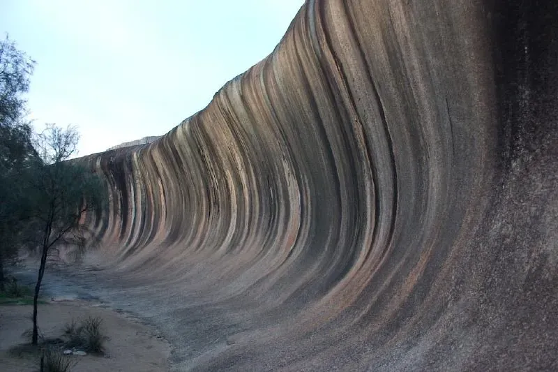
I think there is something uniquely disorienting about Wave Rock. You drive through endless wheat fields in the Australian outback, and then suddenly, out of flat, dry land, a massive granite wave rears up as if the ocean itself got lost and froze mid-crash. Wave Rock is a natural rock formation shaped like a tall breaking ocean wave, about 15 metres high and around 110 metres long, forming the north side of a solitary hill known as Hyden Rock. The 2.7-billion-year-old, 110-metre-long slab of naturally eroded rock captured the world’s attention in the 1960s, when a photograph of it was published in National Geographic magazine.
Because of its shape, it’s easy to assume that Wave Rock formed because of flowing water or blowing wind, but that doesn’t seem to be the case. There’s not enough wind or flowing water in the area to cause that much erosion, even over millions of years. The biggest clue is that the landform’s wave shape continues below the current ground level for at least a metre without flattening out, leading to the conclusion that it was born underground. Wave Rock has cultural significance to the Ballardong people, who call it Katter Kich. Local tribes believed that Wave Rock was a creation of the Rainbow Serpent, created in her wake as she dragged her swollen body over the land.
The Chocolate Hills of the Philippines: A Landscape From a Dream
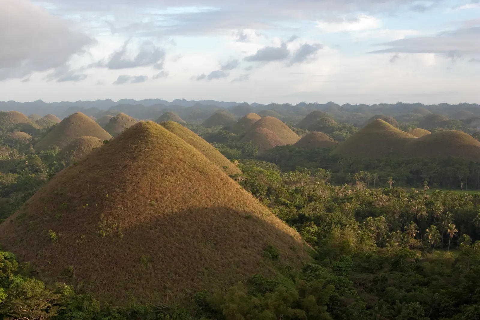
You know that moment in a dream when the landscape looks almost normal, but not quite? That is exactly what the Chocolate Hills feel like. The Chocolate Hills are a truly unusual rock formation, consisting of at least 1,260 hills, with as many as 1,776 hills spread over an enormous area of more than 50 square kilometres. These cone-shaped hills are made of limestone and covered in lush green vegetation during the rainy season, turning brown in the dry season, resembling rows of chocolate kisses.
They are on the Philippine Tourism Authority’s list of tourist destinations in the Philippines, have been declared the country’s third National Geological Monument, and have been proposed for inclusion in the UNESCO World Heritage List. Geologists think these hills are made of limestone shaped by water erosion, but no one has really nailed down exactly how they formed into such consistent, strangely spaced cones. The scientific community is still working on a fully satisfying explanation, which somehow makes the whole thing more wonderful, not less.
The Cave of the Crystals, Mexico: A World Beneath the World
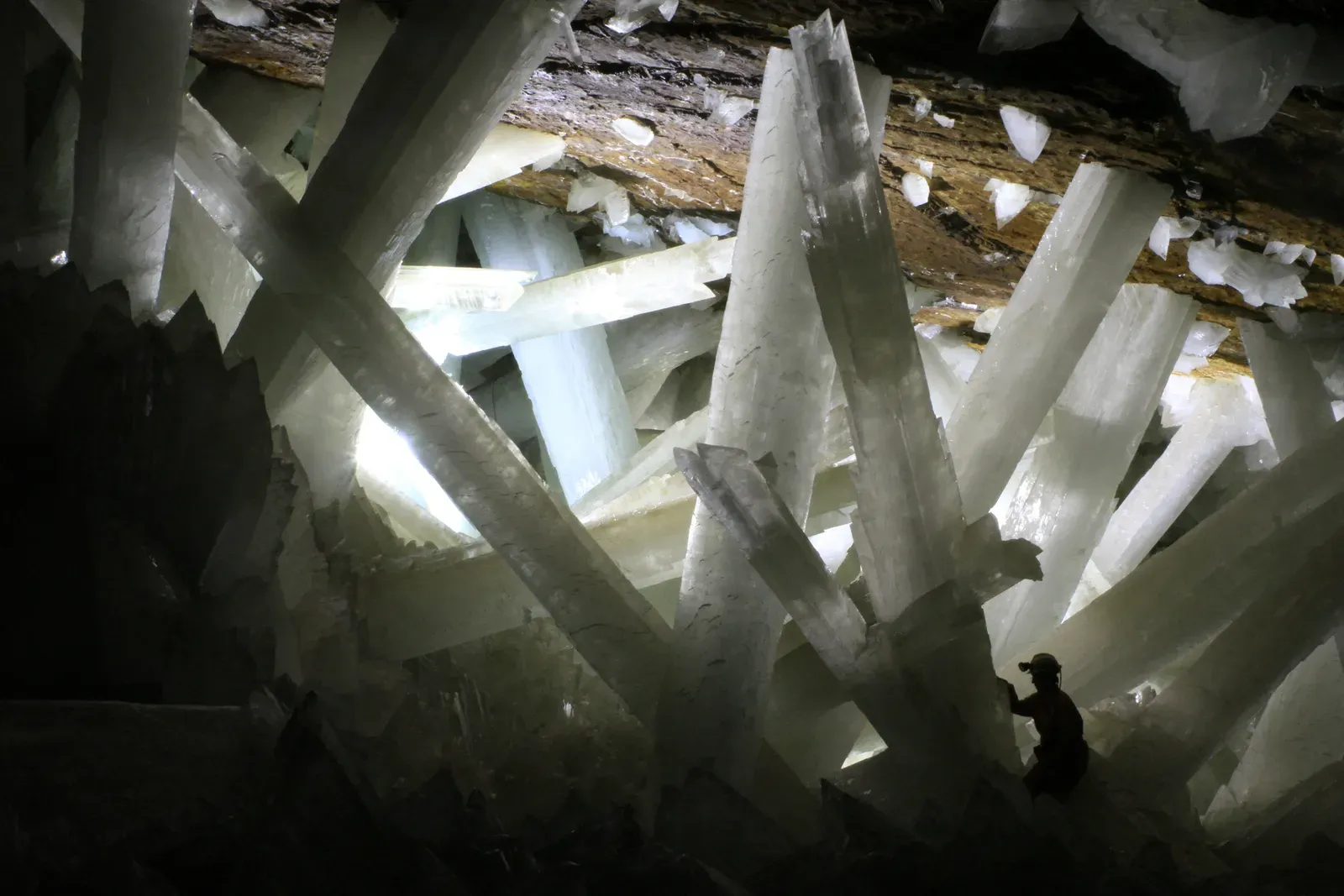
If you were to design a cave from scratch for a science fiction film, you might come up with something like the Cave of the Crystals in Naica, Mexico. The otherworldly crystals in the Cave of the Crystals in Mexico can reach sizes larger than houses, by far the largest such crystals known on the planet. They apparently grow at incredibly slow rates, gypsum formations that take as long as a million years to reach more than two stories tall.
Researchers speculate that microscopic pockets of liquid within these giant crystals might hold microbes. The cave itself is so hot, reaching temperatures near 60 degrees Celsius with extreme humidity, that unprotected humans can only survive inside for about ten minutes. It’s hard to say for sure what is more staggering: the sheer scale of the crystals or the fact that they grew in total darkness, in superheated mineral-rich water, completely unseen for hundreds of thousands of years. The Earth was keeping a secret down there, and it’s a spectacular one.
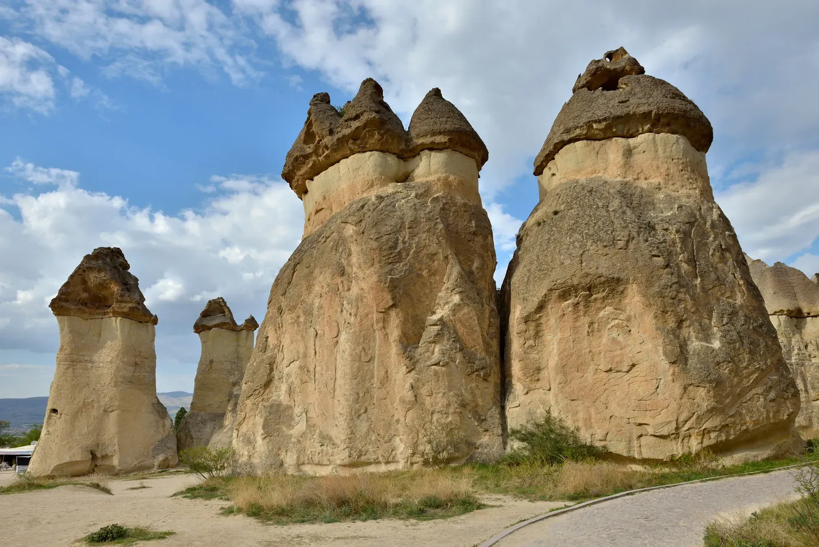
Cappadocia’s Fairy Chimneys, Turkey: Where People Carved Homes Into the Sky
Feel free to use my photos, but please mention me as the author and send me a message.
This image is not in the public domain. Please respect the copyright protection. It may only be used according to the rules mentioned here. This specifically excludes use in social media, if applicable terms of the licenses listed here not appropriate.
Please do not upload an updated image here without consultation with the Author. The author would like to make corrections only at his own source. This ensures that the changes are preserved.Please if you think that any changes should be required, please inform the author.Otherwise you can upload a new image with a new name. Please use one of the templates derivative or extract., CC BY-SA 3.0)
Cappadocia, in the Central Anatolian Plateau of Turkey, is famous for its unique landscape and unusual rock formations. The development of this landscape dates back to the Late Miocene epoch, roughly 10 million years ago, when volcanoes spread pyroclastic deposits over an area of about 20,000 square kilometres. The volcanism continued for several millions of years and laid down thick and colourful ignimbrite layers.
The evolution of the Cappadocian landscape starts with nearly horizontal plateaus, which are then dissected along cooling fractures to form mushroom-like structures locally known as “fairy chimneys.” Different layers of ignimbrites have different resistance to erosion, and when the chimneys are isolated, the caps play an important role in slowing further erosion of the softer layers beneath them. These hoodoos in Cappadocia are so liveable that houses have been carved directly into the formations. Entire underground cities were dug out here too, making Cappadocia one of the few places on Earth where geology quite literally became architecture.
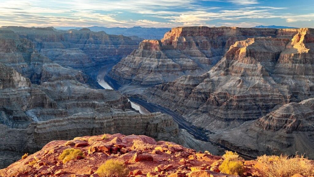
The Great Unconformity: A Billion Years of Missing Rock
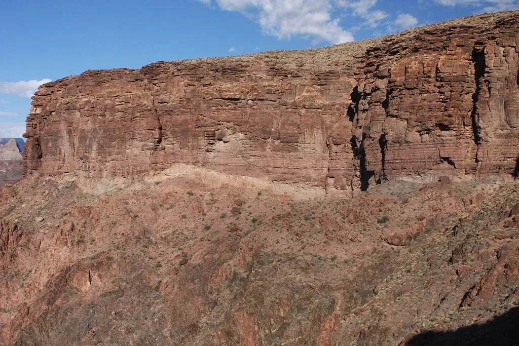
Of all the bizarre geological mysteries on this list, this one might be the most mind-bending, because it is about something that is not there. The Great Unconformity is a huge gap in the geological record: layers of rock dating from about 1.2 billion to 250 million years ago are completely missing from certain areas around the globe. This enormous chunk of lost time can be seen clearly in the stratigraphy of the Grand Canyon, where there is plenty of rock full of fossils from the Cambrian period, but the layer beneath it is basement rock formed roughly 1 billion years ago and empty of fossils.
An emerging theory, called “Snowball Earth,” may explain where the rock disappeared to. Around 700 million years ago, Earth was encased in snow and ice. Moving glaciers peeled off the planet’s crust with the help of lubricating sediments, pushing it into oceans where it was reabsorbed by subducting tectonic plates. Many questions remain unanswered, though, such as the multimillion-year gap between the end of Snowball Earth and the start of the Cambrian period. You can stand at the rim of the Grand Canyon and stare at that invisible gap in time. Nearly a billion years, gone. No explanation yet that fully satisfies every geologist. The Earth, it turns out, keeps some of its deepest secrets well.
Conclusion: The Planet That Never Stops Surprising You

The Earth is not a static backdrop to human history. It is an active, restless, ancient machine that has been building wonders long before we arrived to name them. The formations explored here are not outliers. They are reminders that the world operates on timescales and forces that dwarf anything we can fully grasp. A crystal that took a million years to grow. A salt flat that holds enough lithium to power the world’s electric cars. A glacier that bleeds red in one of the most remote places on the planet.
Every one of these formations carries a story that stretches back millions, sometimes billions, of years. You don’t need to be a geologist to feel the weight of that. You just need to stand in front of one of these places and let it sink in. The planet has been at work for an unimaginable length of time, and it is still not finished. Next time you walk across ordinary ground, you might want to wonder: what is forming beneath your feet right now? What will it look like in a hundred million years? What would you have guessed?