If you want to feel time in your bones, not just read about it in a textbook, the United States is one of the best places on Earth to do it. Scattered across deserts, canyons, mountains, and badlands are rocks that quietly record nearly four billion years of planetary drama: colliding continents, vanished oceans, mass extinctions, and climates so alien they might as well belong to another world.
As you explore these places, you are not just sightseeing; you are walking into chapters of a story that started long before humans, trees, or even complex animals existed. You stand where shorelines came and went, where dinosaurs sank into mud, where volcanic ash entombed forests, and where ancient microbes built reefs in shallow seas that no longer exist. These ten US geological sites will help you read that story for yourself and feel just how deep Earth’s past really runs.
Grand Canyon, Arizona: A Vertical Timeline Two Billion Years Deep
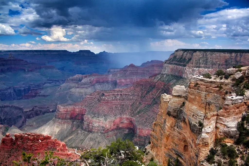
When you first look over the edge of the Grand Canyon, it is easy to focus on the sheer size of the chasm, but the real shock hits when you realize you are looking at nearly two billion years of history in one sweeping view. At the very bottom, the dark, crumpled rocks of the Vishnu Basement – mainly schists and related rocks – formed more than one and a half billion years ago from ancient volcanic islands and sediments mashed and baked during early continental collisions. Above them, younger, flatter sedimentary layers stack up like pages in a book, each one a different environment: tidal flats, deserts, shallow seas, and river systems laid down over hundreds of millions of years. ([en.wikipedia.org](https://en.wikipedia.org/wiki/Geology_of_the_Grand_Canyon_area?utm_source=openai))
You also see something you rarely get to see so clearly anywhere on the planet: time missing. The Great Unconformity, a huge gap where hundreds of millions of years of rock were eroded away, separates those ancient basement rocks from much younger layers. That break hints at powerful forces – uplift, erosion, changing sea levels – that can completely erase pieces of the record. As you hike down from the rim toward the river, every switchback drops you deeper into time, until you are walking through rocks that formed long before multicellular life flourished in the oceans. You are not just descending into a canyon; you are walking backward through Earth’s memory.
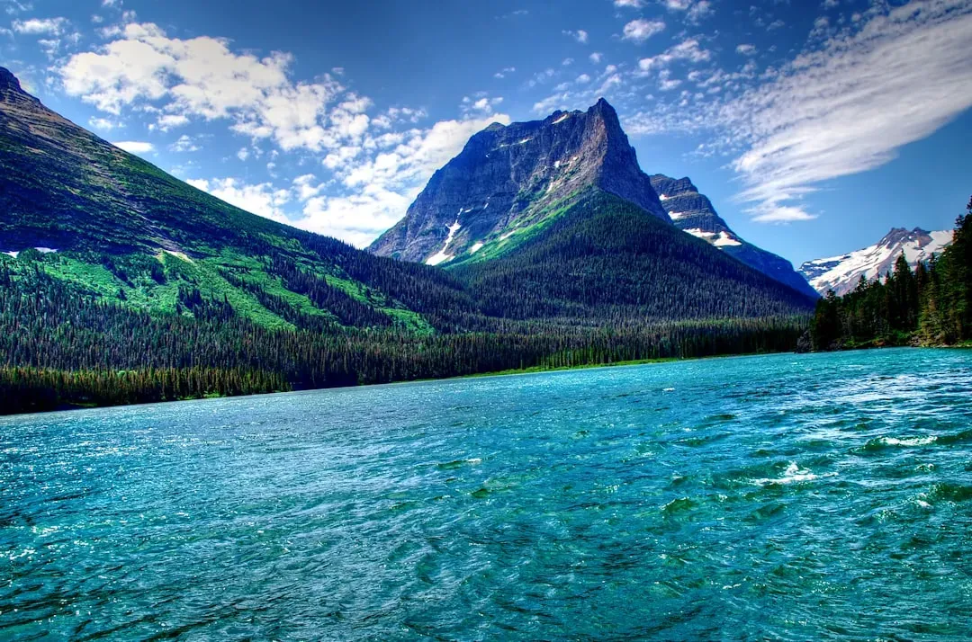
Yellowstone, Wyoming–Montana–Idaho: A Living Window Into Earth’s Fiery Interior
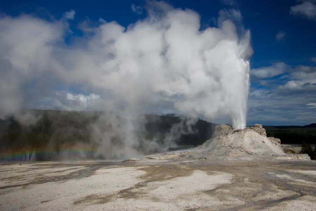
At Yellowstone, you are standing over one of the most dramatic expressions of Earth’s internal heat anywhere on the globe. The geysers, hot springs, and bubbling mud pots that surround you are the surface symptoms of a vast volcanic system that has erupted in truly colossal events over the last few million years. Several of those eruptions were powerful enough to blanket large parts of North America in ash and carve out giant calderas that only later filled and softened into the landscape you see now. The hot waters flowing through the rocks today carry dissolved minerals that continually build terraces, cones, and colorful mineral crusts, writing the story of heat and water in real time.
But Yellowstone’s secrets of deep time go beyond dramatic eruptions. The park sits at the leading edge of a hotspot that has burned its way across the continent, leaving a chain of progressively older volcanic fields stretching to the west. When you follow that trail, you essentially trace the motion of the North American Plate over tens of millions of years, like watching a slow-motion plate-tectonic movie. Combining that with fossil forests, glacial valleys, and ancient lake sediments, you can read Yellowstone as a layered archive of shifting climates, changing landscapes, and a restless planet that never stays still for long.
John Day Fossil Beds, Oregon: Colorful Hills and a Record of Changing Worlds
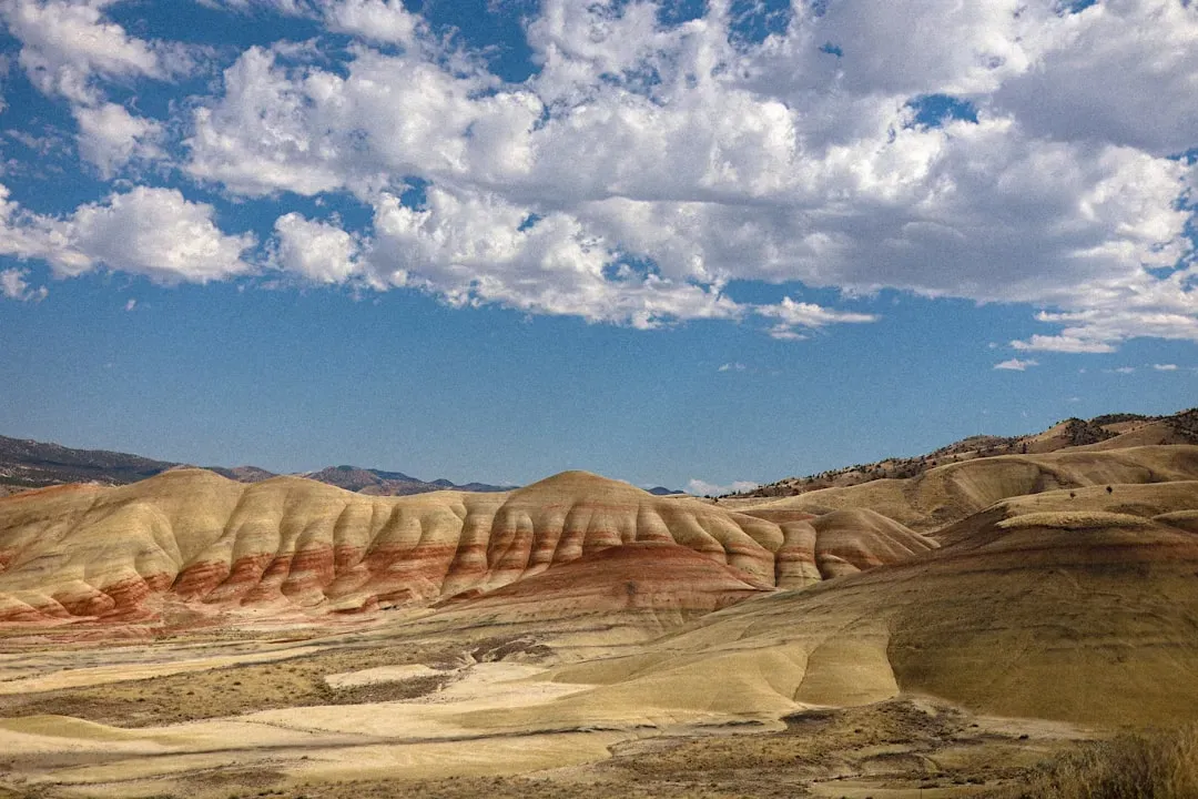
When you walk through the John Day Fossil Beds in Oregon, the layered, pastel-colored hills feel almost otherworldly, but they hold a very down-to-Earth story about how environments and animals transform over tens of millions of years. The rocks here preserve an unusually continuous record from roughly the Late Cretaceous into the Miocene, capturing ancient river deltas, volcanic ash layers, and floodplain deposits. Buried within those layers are remarkably well-preserved fossils of early horses, rhinos, saber-toothed relatives, and plant communities that lived in climates that shifted from warm, lush forests to cooler, drier shrublands. ([nps.gov](https://www.nps.gov/joda/learn/nature/geologicformations.htm?utm_source=openai))
What makes John Day so powerful for you as a visitor is that you can literally see climate and ecosystems morph in the rock colors and formations around you. Volcanic eruptions from distant volcanoes repeatedly dusted this region with ash, which later hardened into rock and preserved the remains of the animals and plants that died here. As you trace the layers upward, species appear, change, and vanish, revealing how life responds to rising mountains, shifting rainfall patterns, and changing temperatures. It is like scrolling through an ancient social feed of evolution, except the posts are bones, leaves, and the subtle chemistry of buried soils.
Badlands National Park, South Dakota: Fossil-Rich Landscapes of Lost Mammal Worlds
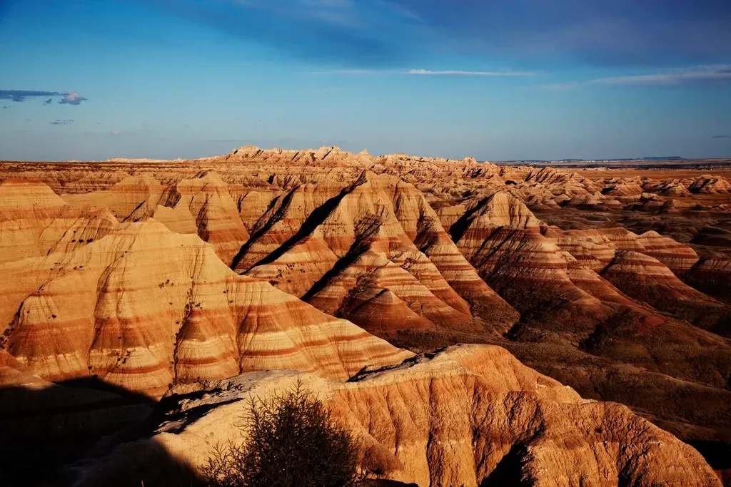
The eroded spires and gullies of Badlands National Park may look harsh and lifeless at first glance, but they hide one of the richest records of early mammal evolution in North America. The soft sedimentary rocks here, mostly from the late Eocene and Oligocene epochs, formed from river and floodplain deposits that once supported thriving ecosystems of early camels, three-toed horses, oreodonts, and other now-extinct mammals. Over time, wind and water stripped away the upper layers, leaving a maze of buttes and ravines that constantly spill new fossils onto the surface for paleontologists – and sometimes lucky visitors – to find.
For you, the Badlands are a crash course in how quickly landscapes and life can change on geological timescales. The rocks record a period of cooling climate and expanding grasslands, when forests retreated and grazing mammals diversified into new roles. You can stand in one spot and literally see stacked worlds: old river channels, buried soils, and volcanic ash layers that serve as time stamps. Each small bone in the dirt is a data point in a long-running natural experiment, showing how mammals adapted, migrated, or disappeared as the Great Plains evolved from subtropical woodlands into the open prairies you recognize today.
Devils Tower, Wyoming: The Frozen Heart of an Ancient Volcano
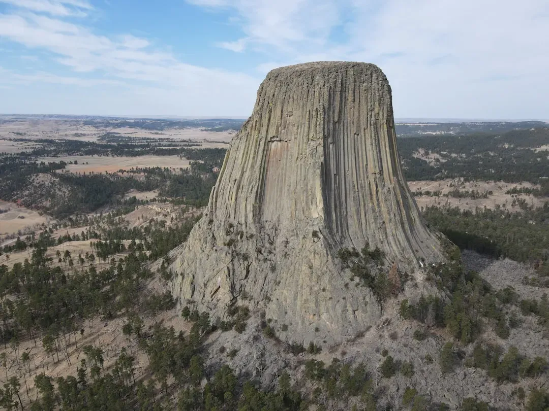
Devils Tower rises from the Wyoming landscape like something planted by a giant, but what you see is actually the exposed core of an ancient volcanic structure. Molten magma once pushed up into overlying sedimentary rocks here, cooling slowly underground to form tall, hexagonal columns of igneous rock. Over millions of years, softer surrounding rocks eroded away, leaving the resistant central plug standing alone. When you walk the loop trail around its base, you are circling what used to be a molten intrusion, now weathered but still holding the shape and texture of its fiery origin.
This site gives you a tangible feel for how erosion is just as important as eruptions in shaping the planet’s surface. Without the patient scouring of water, wind, and gravity, Devils Tower would still be buried and invisible. By exposing this volcanic heart, erosion lets you read an interior chapter of Earth’s volcanic processes that is usually hidden. You can see the vertical columns that formed as the magma slowly cooled and contracted, and you can imagine the wider volcanic landscape that once surrounded it, long since shaved off and carried away as sediment to distant basins and seas.
Craters of the Moon, Idaho: A Young Lava Landscape With Ancient Lessons
At Craters of the Moon, you step into a landscape so black and jagged it almost feels like you have left Earth. The vast lava fields, cinder cones, and lava tubes here formed from eruptions over the last several thousand years, geologically speaking a blink of an eye. But this young volcanic terrain teaches you about processes that have been shaping the planet for billions of years: how magma rises along faults, how gases escape, and how lava spreads, cools, and fractures. You can walk on ropey pahoehoe flows, climb cinder cones, and peer into collapsed lava tubes to see how the molten interior once drained away.
Even though the rocks themselves are relatively young, the setting reflects deeper, older forces tied to the movement of the North American Plate over time. The volcanic fields align with a zone of crustal stretching tied to wider tectonic patterns that have existed for tens of millions of years. When you piece together Craters of the Moon with other volcanic and tectonic features across the West, you get a sense that what looks like a frozen disaster zone is actually a momentary snapshot in a long-running cycle of rifting, magmatism, and surface renewal that stretches deep into Earth’s past.
Glacier National Park, Montana: Ancient Microbial Seas and Carved Ice Valleys
Glacier National Park stuns you today with sharp peaks and U-shaped valleys carved by ice, but some of its most important secrets belong to a far older world. Near some areas, you can find Precambrian rocks that preserve stromatolites – layered structures built by microbial communities in shallow seas more than a billion years ago. These ancient microbial mounds record a time when simple life forms were already reshaping the planet’s chemistry, especially oxygen levels in the atmosphere and oceans. ([nps.gov](https://www.nps.gov/subjects/fossils/about-fossils.htm?utm_source=openai))
Layer those fossil-rich ancient seas under the evidence of much more recent glaciations, and you get a staggering time stack. Ice has repeatedly advanced and retreated here during the last couple of million years, sculpting cirques, hanging valleys, and sharp arêtes that you hike through today. When you stand on a ledge looking across the park, you are literally seeing the interplay of two extremes: some of the oldest visible sedimentary rocks in the region, built by microscopic life, draped in the scars of very recent ice ages. It is a vivid reminder that Earth recycles and repurposes its landscapes, combining traces of deep microbial time with the raw force of moving ice.
Petrified Forest National Park, Arizona: Stone Trees From a Lost Triassic Ecosystem
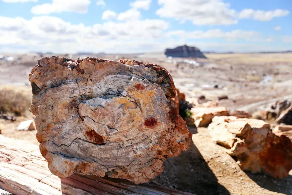
In Petrified Forest National Park, your brain keeps insisting you are looking at logs until you touch one and feel solid quartz under your hand. These petrified trees lived and died during the Late Triassic, over two hundred million years ago, when this region was a lowland floodplain near the equator. Fallen trunks were buried in sediment and soaked in mineral-rich groundwater, which slowly replaced the original wood with silica and other minerals. Over immense spans of time, those minerals crystallized into colorful varieties of quartz, preserving growth rings, bark textures, and internal structures in spectacular detail.
The surrounding rocks also tell you about the strange world those trees once shaded. Fossils of early dinosaurs, crocodile relatives, and other reptiles show that this was a dynamic, swampy landscape full of evolutionary experiments before dinosaurs came to dominate the Jurassic. As erosion strips away the softer mudstones and sandstones, it frees the petrified logs and scatters them across the surface like driftwood from another age. When you wander among them, you are walking through an open-air time capsule that captures both the biology and the sedimentary processes of a chapter in Earth’s history that feels almost mythic compared to the present day.
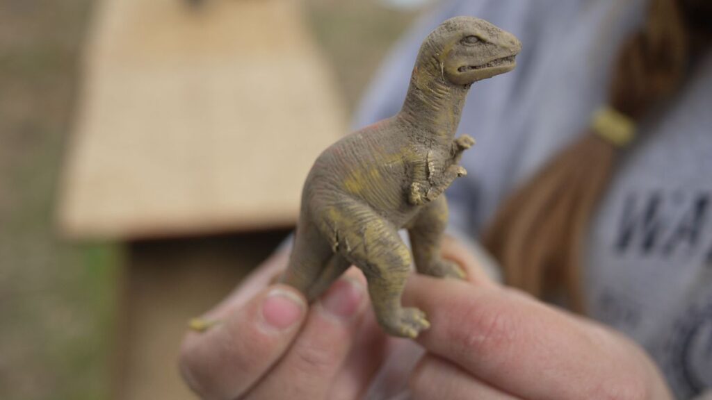
Morrison Formation Sites, Western US: Dinosaur Graveyards of the Late Jurassic
Across several states in the American West, from Colorado and Utah to Wyoming and New Mexico, the Morrison Formation crops out as a seemingly ordinary set of mudstones and sandstones. Once you learn to read it, though, you realize you are standing in the middle of one of the most important dinosaur archives on the planet. These rocks were laid down in river valleys, floodplains, and lakes about one hundred and fifty million years ago, preserving the bones of famous giants like Apatosaurus, Diplodocus, Stegosaurus, and Allosaurus. Many sites within the Morrison have yielded dense bone beds that let you reconstruct ancient ecosystems in surprising detail.
For you as a visitor, places like Dinosaur National Monument or various quarry sites become doorways into that Late Jurassic world. You see the actual sediment layers that entombed whole skeletons during floods or droughts, and you learn how subtle differences in grain size, color, and mineral content record different parts of the landscape. Even though the dinosaurs steal the show, the Morrison also preserves trackways, plant remains, and invertebrate traces that round out the picture. Looking beyond the individual skeletons, you get to think about long-term patterns: how climate zones shifted, how river systems migrated, and how continents slowly changed shape as the supercontinent Pangaea continued to break apart.
Black Hills and Ancient Gneisses, South Dakota–Wyoming: Glimpses of Earth’s Early Crust
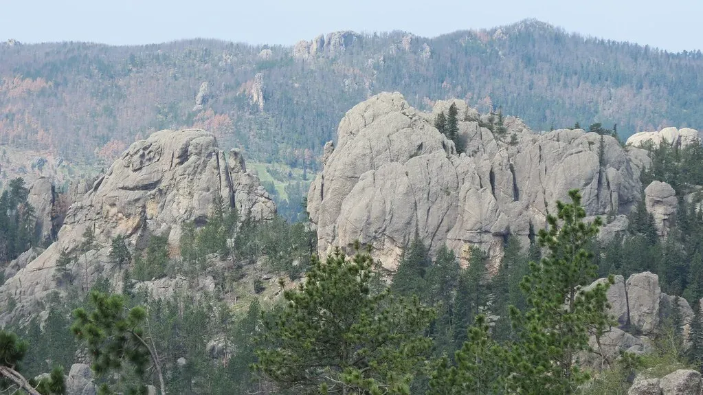
In and around the Black Hills of South Dakota and Wyoming, you can find some of the oldest rocks in the United States, including ancient gneisses and schists that formed well over two and a half billion years ago. These high-grade metamorphic rocks are pieces of early continental crust that survived billions of years of tectonic recycling. When you see their banded patterns and folded layers, you are looking at the frozen record of deep crustal processes – burial, heating, deformation – that took place long before complex life appeared. They are, in a sense, the bones of an early version of the continent you live on now.
Surrounding these old crystalline cores are younger sedimentary and igneous rocks, along with evidence of multiple uplift and erosion cycles that have reshaped the region repeatedly. The Black Hills themselves are like a geological onion, with older rocks exposed in the center and progressively younger rocks around the edges. When you walk or drive through the area, you are really circling a time spiral: ancient crust in the middle, younger layers outside, and modern soils and vegetation draped over everything. It is one of the clearest places in the country where you can feel, in your own footsteps, how continents grow, warp, and weather across immense spans of time.
Conclusion: Standing Still While Time Flows Beneath Your Feet
As you move from the Grand Canyon’s abyss to Yellowstone’s steaming basins, from fossil-rich badlands to buried impact scars, you start to realize that deep time is not an abstract number; it is a physical thing you can touch. Each site you visit gives you a different angle on that reality: ancient microbial reefs, petrified forests, dinosaur graveyards, volcanic hearts, and basement rocks that witnessed early continental collisions. You learn to read layers, unconformities, fossils, and landforms the way you read words on a page, and suddenly the Earth around you stops being a static backdrop and becomes a living archive.
The real shift happens inside you, though, when you recognize that your own lifetime is a hair-thin scratch on this enormous timeline. Instead of making you feel small in a depressing way, it can be strangely freeing: you get to be one curious observer in a story that began long before you and will continue long after. Next time you stand at a viewpoint or pick up an interesting rock on a trail, you might find yourself asking a new question: if this stone could tell its full story, how far back would it take you – and what part of that journey would you most want to see?