If you ever need proof that Earth is not just a planet but an artist with an absurdly long attention span, you only have to look at its rocks. Over millions of years, invisible forces have bent, cracked, melted, dissolved, and sandblasted solid stone into shapes so bizarre and beautiful that they almost feel unreal. You show up with a camera and a pair of hiking boots; the planet shows up with several hundred million years of tectonics and erosion.
As you explore these formations, you’re really time-traveling. Every arch, canyon, column, and cave is a frozen moment in a story that’s still unfolding. The landscapes you see today are not finished products; they’re snapshots in an ongoing experiment driven by gravity, water, ice, wind, and fire. Once you start recognizing the patterns behind the beauty, you’ll never look at a cliff or a ridgeline the same way again.
1. The Grand Canyon, USA – A Mile-Deep History Book Carved by a River
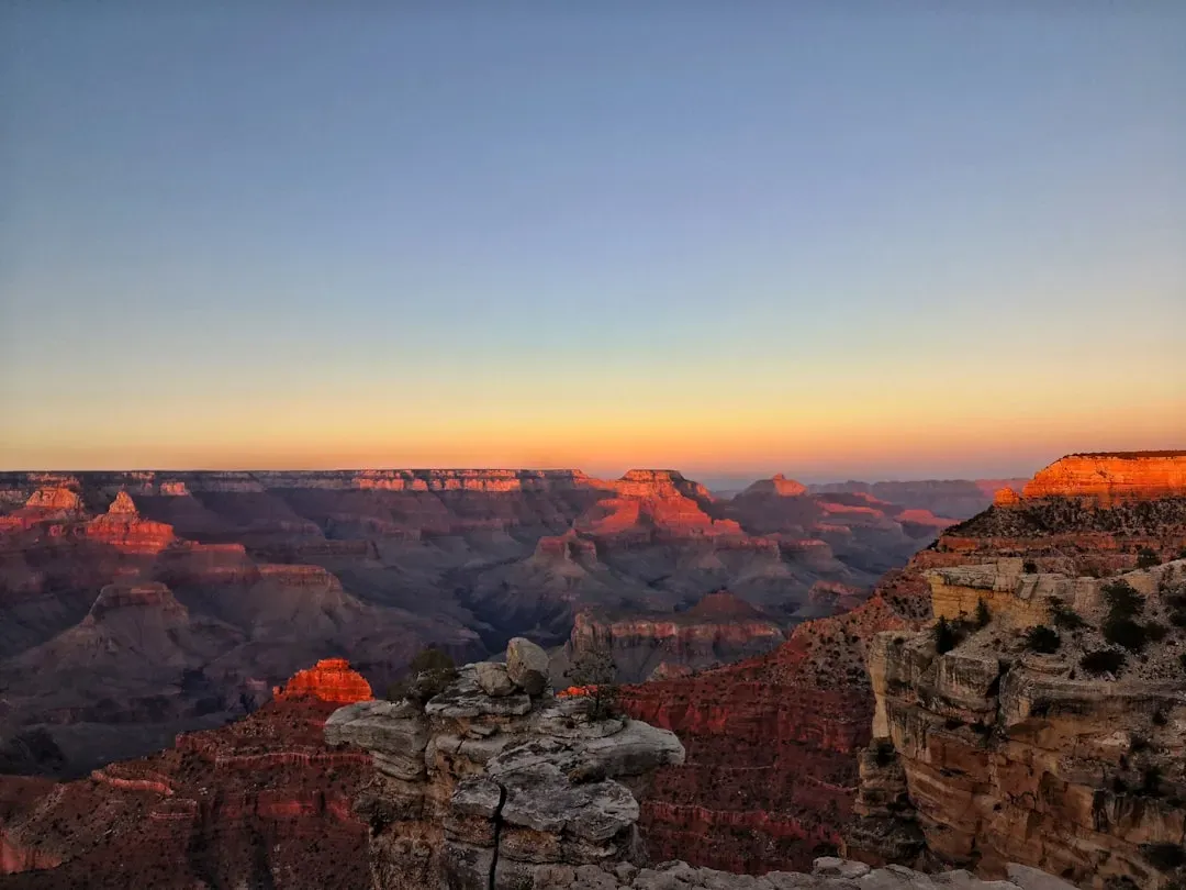
When you stand on the rim of the Grand Canyon, you are looking down into almost two billion years of Earth’s history laid open like a giant encyclopedia. Layer upon layer of sandstone, limestone, and shale record ancient seas, deserts, and swamps that came and went long before humans existed. What makes it truly jaw-dropping is that the Colorado River, powered by gravity and a steadily uplifting plateau, sliced this enormous trench through solid rock over millions of years.
You can think of the Colorado River as a relentless sculptor with a very slow chisel: water, sediment, and time. As the Colorado Plateau gradually rose, the river cut down faster, deepening the canyon while side streams gnawed away at the walls and widened it into a complex maze of tributary canyons. If you hike from the rim to the river, you’re literally walking back through time, with each step taking you deeper into older rock, until you stand beside some of the oldest exposed rocks on the planet.
2. Giant’s Causeway, Northern Ireland – Hexagons Forged in Fire
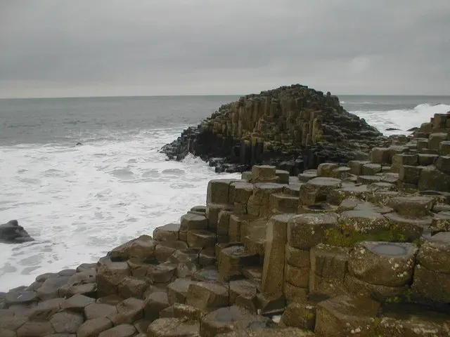
At first glance, Giant’s Causeway looks so geometric that you might suspect some ancient civilization carved it – until you learn that the sculptor was cooling lava. Around sixty million years ago, intense volcanic activity flooded this part of what is now Northern Ireland with thick basalt lava flows. As that lava slowly cooled and contracted, it cracked into tens of thousands of columns, many of them forming those eerie, almost perfect hexagons you can walk across today.
Imagine drying mud on a hot day forming polygonal cracks; now scale that up to a searing-hot lava flow tens of meters thick. The same physics is at work, just with molten rock instead of wet soil. Over time, waves and weather stripped away softer material and sharpened the shapes, leaving behind this surreal stone pavement spilling into the sea. When you hop from column to column, you’re literally walking on a frozen pattern of ancient thermal stress.
3. Uluru (Ayers Rock), Australia – A Desert Monolith from a Buried Mountain Range
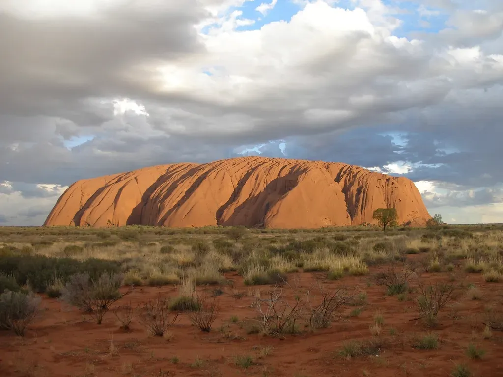
Uluru feels almost otherworldly: a single massive sandstone monolith rising abruptly from an otherwise flat desert plain. What you see, though, is just the tip of an ancient geological iceberg. The rock that makes up Uluru was once part of a thick pile of sand and gravel deposited in huge alluvial fans at the base of long-eroded mountain ranges hundreds of millions of years ago. Those sediments were buried, compressed, and turned into hard rock, then tilted and later exposed as softer surrounding layers wore away.
Over immense spans of time, erosion removed the weaker rocks around Uluru, leaving this resistant block standing like a solitary sentinel. Wind, rain, and temperature swings didn’t spare it entirely; they carved out caves, flutes, and smooth streaks that accent its surface like brushstrokes on a sculpture. When you circle its base, you’re tracing the edge of a structure that continues underground, a reminder that the landscapes you see are just what erosion has chosen to reveal so far.
4. Arches National Park, USA – Stone Fins Turned into Gravity-Defying Arches
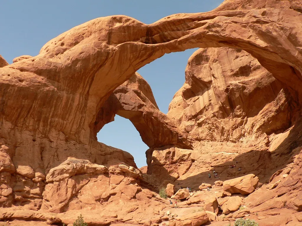
In Arches National Park in Utah, you walk through a forest made not of trees but of stone fins, spires, and delicate bridges. Most of the famous arches, like Delicate Arch and Landscape Arch, formed in thick layers of Entrada Sandstone that were fractured by ancient movements of buried salt and regional uplift. Those fractures divided the rock into narrow slabs – fins – that erosion could then attack from both sides. Over time, small holes grew larger as wind, water, and gravity pried loose weaker pieces.
Eventually, some of those holes became full arches, with a graceful span connecting two massive supports. It’s a great example of how instability can create beauty: once a small cavity forms, stress concentrates around it, encouraging more rock to break away and enlarge the opening. You’re essentially looking at rock caught mid-collapse, frozen in a temporary balance. Every arch you see is in a race between the forces that created it and the forces that will someday bring it down.
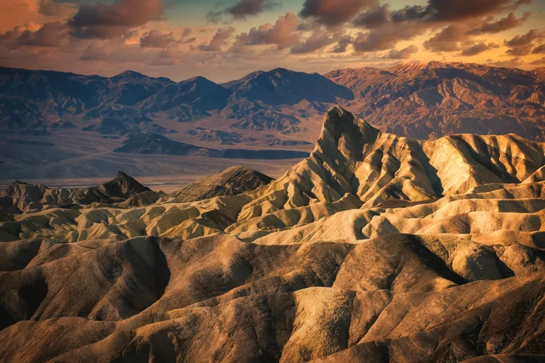
5. Bryce Canyon, USA – Hoodoos Sculpted by Ice and Rain
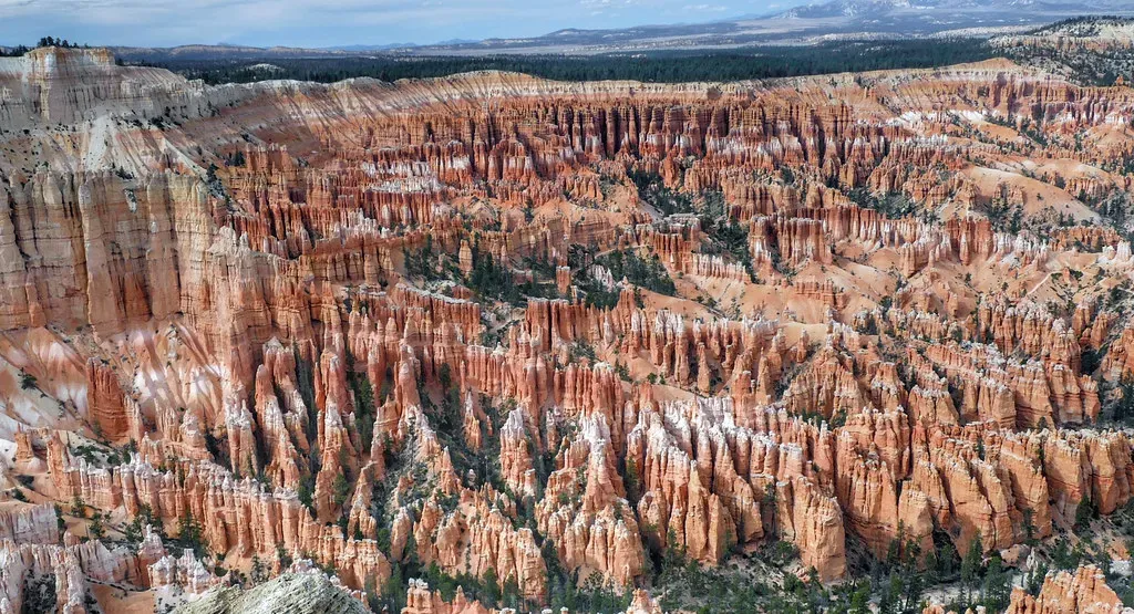
Bryce Canyon’s hoodoos look like a crowd of stone figures gathered for some strange meeting, but they’re actually expressions of something far less mystical: differential erosion. The rock layers here are mostly soft sediments, with harder, more resistant caps perched above weaker material. Water seeps into cracks, and in winter it freezes, expands, and wedges those cracks wider. Over many freeze-thaw cycles, chunks of rock break off unevenly, leaving thin spires protected at the top by a tougher “caprock.”
Rain and surface runoff then carve amphitheaters into the edge of the plateau, exposing these spires like teeth in a slowly eroding jaw. Because no two cracks and no two layers are exactly alike, each hoodoo develops its own bizarre shape and color pattern. When you wander among them at sunrise or sunset, you’re walking through a three-dimensional diagram of how climate and rock type interact, with ice playing the quiet but ruthless role of sculptor.
6. Cappadocia, Turkey – Fairy Chimneys Born from Ancient Supervolcanoes
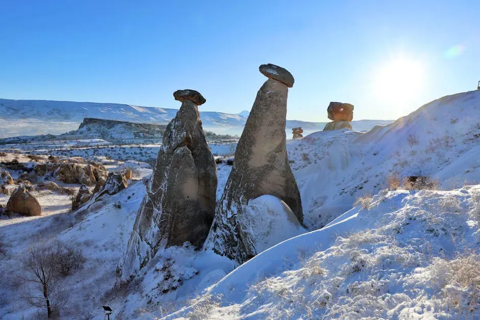
In central Turkey’s Cappadocia region, you find a dreamlike landscape of cones, pinnacles, and so-called fairy chimneys that look like something out of a fantasy movie. The backstory is anything but gentle: millions of years ago, colossal volcanic eruptions blanketed the area with thick layers of ash that welded into a relatively soft rock called tuff. Later, harder layers of basalt and other volcanic materials formed protective caps on top of some portions of that tuff.
Over time, wind and water gnawed away at the tuff, especially where it wasn’t protected by harder rock, carving valleys and leaving isolated columns with capstones on top. Those caps act like umbrellas, shielding the softer rock beneath from erosion and preserving the tall, thin chimneys you see today. When you walk through the valleys, you’re navigating the eroded remains of an ancient volcanic plateau, shaped by the slow, patient work of rainstorms and river channels cutting into a volcanic blanket.
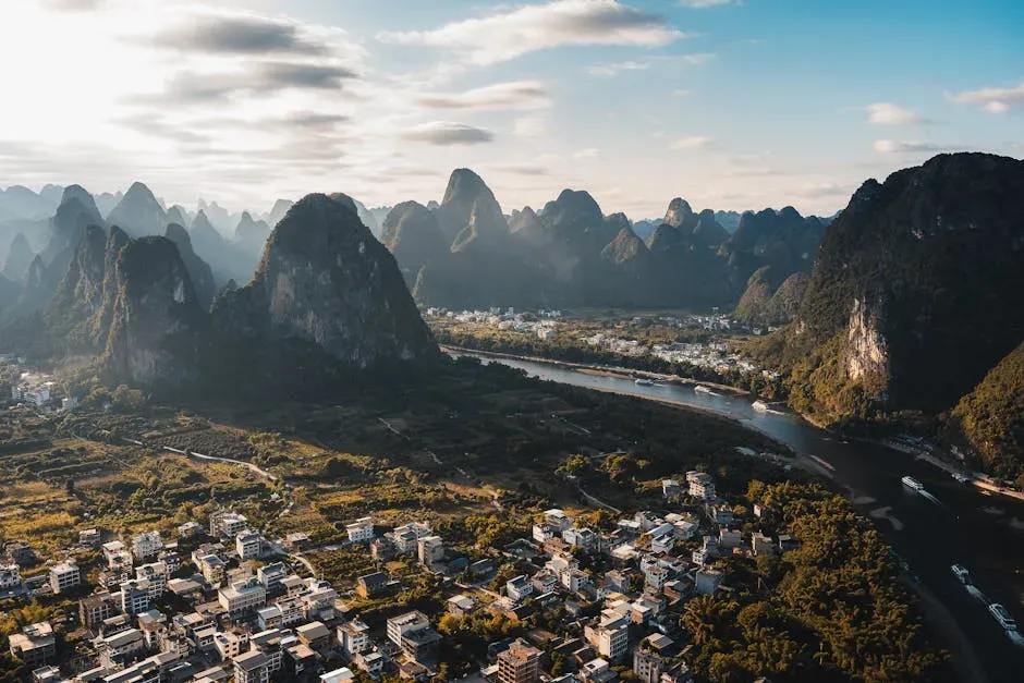
7. Zhangjiajie Sandstone Pillars, China – Forests of Rock Raised by Tectonics and Water
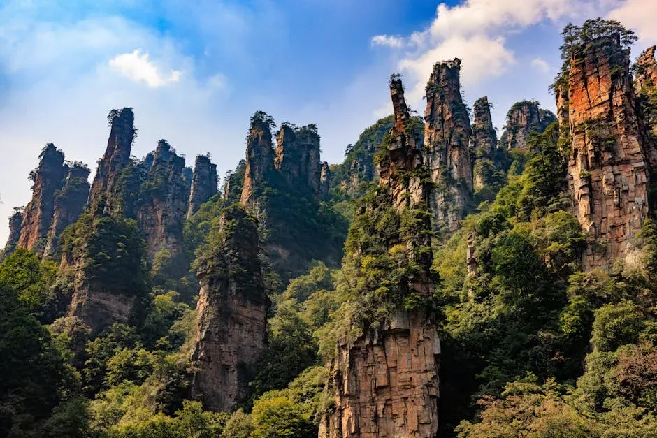
The sandstone pillars of Zhangjiajie National Forest Park in China look like giant stone skyscrapers sprouting trees instead of antennas. These towers began as fairly continuous sandstone layers laid down in an ancient basin. Later, tectonic forces lifted and fractured that rock, creating a dense network of joints and cracks that set the stage for extreme sculpting by weather. Rainwater infiltrated those fractures, dissolving and weakening the rock along them.
As the climate did its work, entire blocks of sandstone slowly detached from surrounding material, leaving behind isolated columns where rock was slightly more resistant or less fractured. Vegetation found footholds on the tops and ledges, adding to the surreal atmosphere. You can picture the landscape as a once-solid plateau that has been extensively “unzipped” along pre-existing lines of weakness, with gravity and flowing water finishing the job over countless wet seasons.
8. Antelope Canyon, USA – A Slot Canyon Painted by Flash Floods
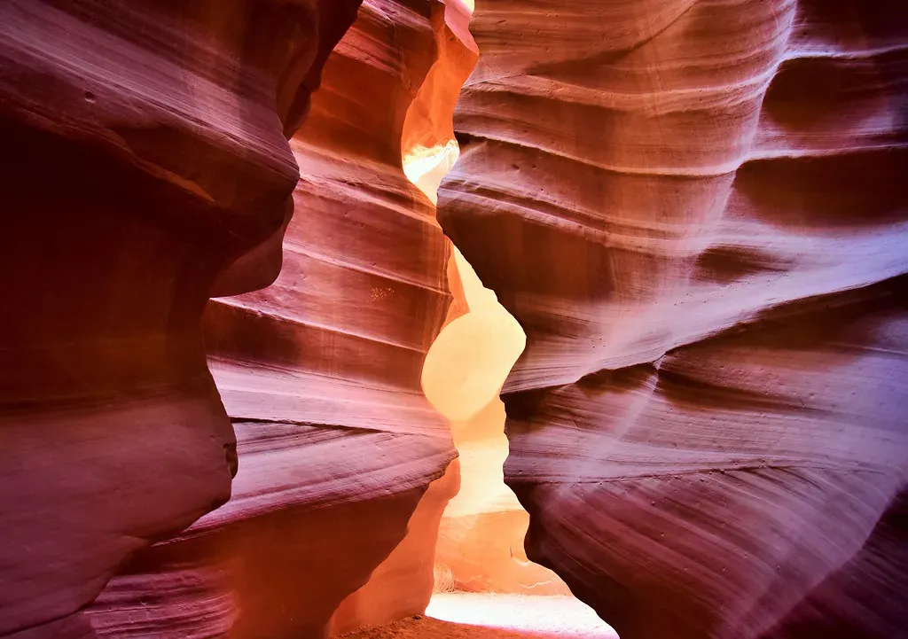
Antelope Canyon in Arizona looks like someone sculpted sandstone with ribbons of light and water. In reality, it’s the work of sudden, violent flash floods funneling through narrow cracks in the rock. The sandstone here is relatively soft, and when rare but intense desert storms hit, torrents of water rush through confined channels, carrying sand and debris that act like a sandblaster. Over thousands of such events, those narrow cracks widened and deepened into twisting slot canyons.
The smooth, flowing curves on the walls come from that abrasive slurry grinding the rock in ever-changing patterns as water levels rise and fall during floods. Because the canyon is so narrow, light filters in from above in delicate beams and glows, highlighting subtle color changes in the rock layers. When you walk through, it feels serene, but you are literally inside a pathway carved by sudden, dangerous floods that still occasionally roar through today.
9. Devil’s Tower, USA – Ancient Magma Revealed by Relentless Erosion
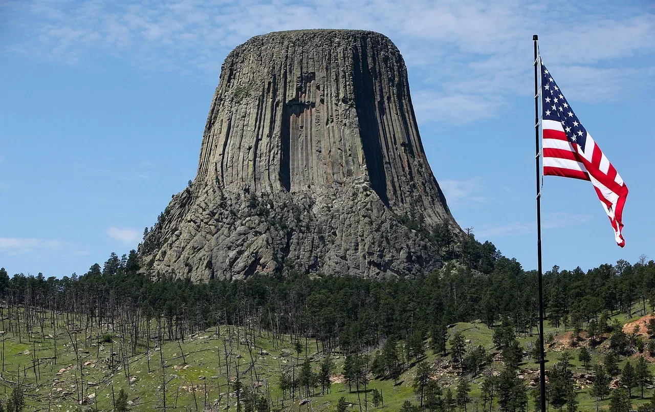
Devil’s Tower in Wyoming rises abruptly from rolling hills like a volcanic monument, its vertical columns forming a striking, fluted pattern. The core of this tower began as molten rock that intruded into surrounding sediments about fifty million years ago, then cooled slowly underground. As it cooled, the rock contracted and cracked into tall, polygonal columns, similar in principle to the basalt columns at Giant’s Causeway but on a larger, vertical scale.
Over millions of years, the softer sedimentary rocks that once buried this intrusion were worn away by streams, rain, and frost, eventually exposing the tougher igneous core. What you see today is that resistant plug standing high above the stripped landscape around it. When you hike around the base, you’re circling the exposed heart of an ancient volcano-related structure, watching erosion’s tendency to tear down the weak and leave the strong standing alone.
10. Karst Caves and Towers, Southeast Asia – Landscapes Dissolved from the Inside Out
In places like Vietnam, southern China, and parts of Thailand, you’ll see dramatic limestone towers rising abruptly from flat plains or the sea, often accompanied by extensive cave systems. These karst landscapes begin with thick beds of limestone or similar soluble rock, laid down long ago in shallow seas. Slightly acidic rain and groundwater, made corrosive by dissolved carbon dioxide, slowly seep into cracks and bedding planes, dissolving the rock from within.
Over time, underground voids become caves, sinkholes open at the surface, and entire blocks collapse, while isolated towers of less-fractured or more resistant rock remain standing. Where uplift and erosion strip away soils, the bare limestone forms those iconic jagged peaks. When you paddle between them or walk through a cathedral-like cave, you’re moving through a landscape that owes its shape as much to chemical processes as to physical erosion, with water patiently eating rock molecule by molecule.
11. Iceland’s Rift Valleys and Volcanic Landscapes – Where Plates Pull Apart Under Your Feet
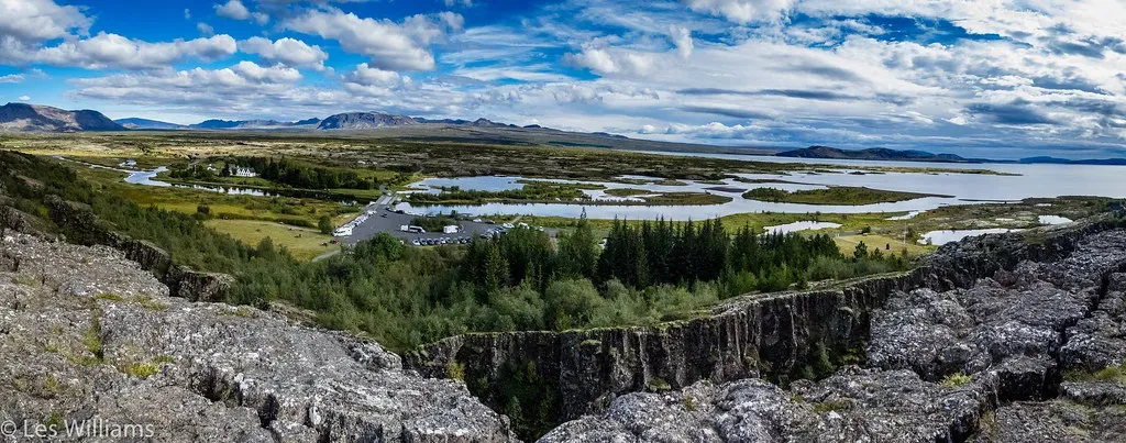
In Iceland, you can literally walk along the boundary where two tectonic plates are pulling away from each other. The island sits astride the Mid-Atlantic Ridge, where the North American and Eurasian plates slowly diverge. As they separate, magma rises to fill the gap, creating new crust, while faults and fissures open at the surface. Over time, repeated eruptions, lava flows, and earthquakes have built and broken this young landscape into rift valleys, steep scarps, and lava plateaus.
Water and ice then get to work on these fresh volcanic materials, carving gorges, waterfalls, and bizarre lava formations. In places like Thingvellir, you can literally see the walls of the rift where the land has dropped between parallel faults. Elsewhere, cooled lava fields twist into strange shapes, and glacial meltwater slices channels through still-young rock. If most landscapes feel like old books, Iceland feels like a draft still being edited, showing you plate tectonics and erosion in fast-forward compared with much of the world.
Conclusion: Reading the Planet’s Slow-Motion Stories
Once you start paying attention, you realize every dramatic landscape you visit is basically a crime scene with the culprits – water, wind, ice, gravity, and heat – still hanging around. The Grand Canyon’s depth, Uluru’s lonely bulk, Antelope Canyon’s curves, and Giant’s Causeway’s geometry all come down to the same core idea: different rocks, under different conditions, respond differently to the same ancient forces. Your eyes catch the beauty, but the real thrill comes when your mind starts to see the processes behind it.
Next time you find yourself staring at a cliff, a cave, or an oddly shaped boulder by a trail, try asking what was here before and what might be here long after you. You do not need to be a geologist to start reading these slow-motion stories; you just need curiosity and a willingness to imagine time on a scale far beyond your own life. And once you see Earth as an artist that never stops working on its canvas, it is hard not to wonder: which of these ancient masterpieces would you most want to stand inside and try to read for yourself?