If you grew up thinking geology was just memorizing rock names, these places will flip that idea on its head. Scattered across the United States, there are lesser-known landscapes where you can literally walk through ancient oceans, volcanic eruptions, lost forests, and vanished climates, sometimes within a single afternoon hike.
In these eight quiet corners, you are not just sightseeing; you are time traveling. You trace the scars of continents tearing apart, lava oozing across plains, and glaciers grinding mountains into dust. By the end, you may find it hard to look at any cliff, canyon, or hillside the same way again.
1. Grand Staircase–Escalante, Utah: A Layered Time Machine Of The West
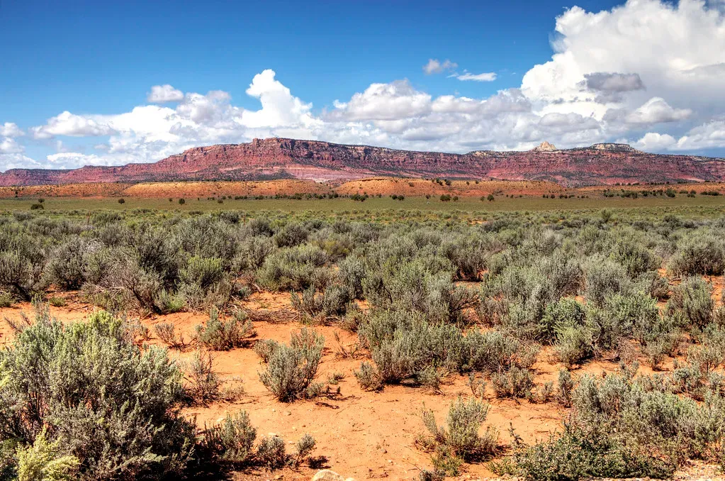
When you stand along Highway 12 looking out over Grand Staircase–Escalante, you are staring into an immense geological staircase that rises from the depths of the Grand Canyon toward the high plateaus of Utah. Each “step” is a stack of sedimentary rocks laid down in ancient deserts, rivers, lakes, and seas, then tilted and hoisted thousands of feet as the Colorado Plateau rose. You can literally drive from younger rocks to older ones, watching colors shift from soft pinks to chocolate browns and blinding whites as you move through tens of millions of years of Earth history. ([en.wikipedia.org](https://en.wikipedia.org/wiki/Grand_Staircase?utm_source=openai))
As you wander side roads toward Devils Garden or along Hole-in-the-Rock Road, you walk between hoodoos and arches carved from Jurassic Entrada Sandstone, a rock that began as dunes in a desert that existed long before the dinosaurs died out. Wind and rare desert floods now chip away at those grains, sculpting bizarre shapes that look like they belong on another planet. What feels like a remote playground of rock is actually an open-air textbook on how climate, sea level, and tectonic uplift shape a continent over time. ([en.wikipedia.org](https://en.wikipedia.org/wiki/Devils_Garden_%28Grand_Staircase%E2%80%93Escalante_National_Monument%29?utm_source=openai))
2. John Day Fossil Beds, Oregon: Volcanic Ash Turned Storybook
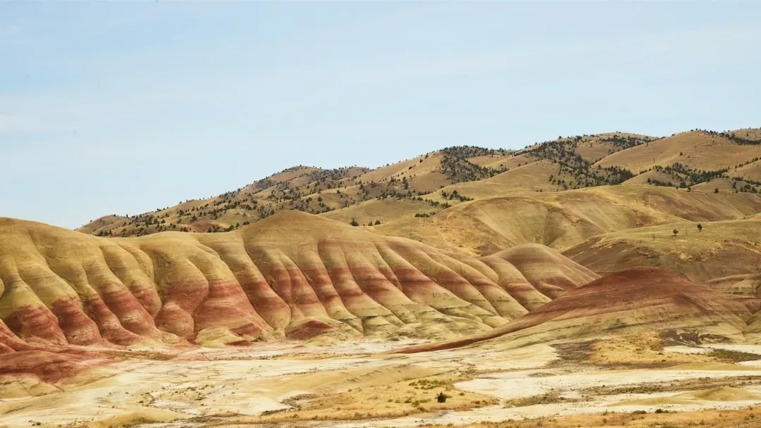
At John Day Fossil Beds in eastern Oregon, you stare at hills so vividly banded in greens, reds, and golds that they almost look fake, but you are really seeing stacked sheets of volcanic ash and ancient soils. For roughly 40 million years, eruptions from distant volcanoes rained ash across river valleys and forests here, burying plants and animals that would later become some of the most detailed fossil records of mammal evolution on the planet. As you walk the trails at Painted Hills or Sheep Rock, you are literally walking over old forests, wetlands, and savannas preserved in place. ([nps.gov](https://www.nps.gov/joda/learn/nature/geologicformations.htm?utm_source=openai))
Because those ash layers hardened into soft sedimentary rocks, modern streams easily carve them into rounded hills and badlands, exposing new fossils almost every season. You can stand at an overlook and imagine the climate shifting from steamy subtropical swamp to cooler, drier steppe as horses shrank, then grew again, and strange ancestors of dogs and cats prowled the floodplains. You are not just looking at pretty stripes; you are seeing how living things struggle, adapt, and sometimes vanish as the planet’s temperature and landscapes lurch from one state to another. ([nps.gov](https://www.nps.gov/joda/learn/nature/geologicformations.htm?utm_source=openai))
3. Craters of the Moon, Idaho: Walking Across Fresh Planetary Scars
If you have ever wondered what it would feel like to walk on newborn Earth, Craters of the Moon in Idaho gets you surprisingly close. Here you wander across dark basalt lava fields that only finished erupting a few thousand years ago along a fracture in the crust called the Great Rift. Instead of one towering cone, you see dozens of cinder cones, fissures, lava lakes, and pressure ridges, all frozen mid-eruption like someone hit pause on a volcanic movie. ([nps.gov](https://www.nps.gov/crmo/learn/education/geology-for-students.htm?utm_source=openai))
When you scramble into lava tubes or look out across the rippled surface of old flows, you are seeing how fluid basalt spreads in thin sheets, sometimes inflating like a balloon as gas-rich magma pushes up from below. The fact that this is a relatively young volcanic field on the otherwise stable interior of North America tells you that even “quiet” parts of the continent can open cracks and leak magma when stress builds. You feel small out there, but you also feel strangely aware that the ground you trust is more restless than it looks. ([nps.gov](https://www.nps.gov/crmo/learn/education/geology-for-students.htm?utm_source=openai))
4. Apostle Islands Sea Caves, Wisconsin: Sandstone Sculpted By Ice And Waves
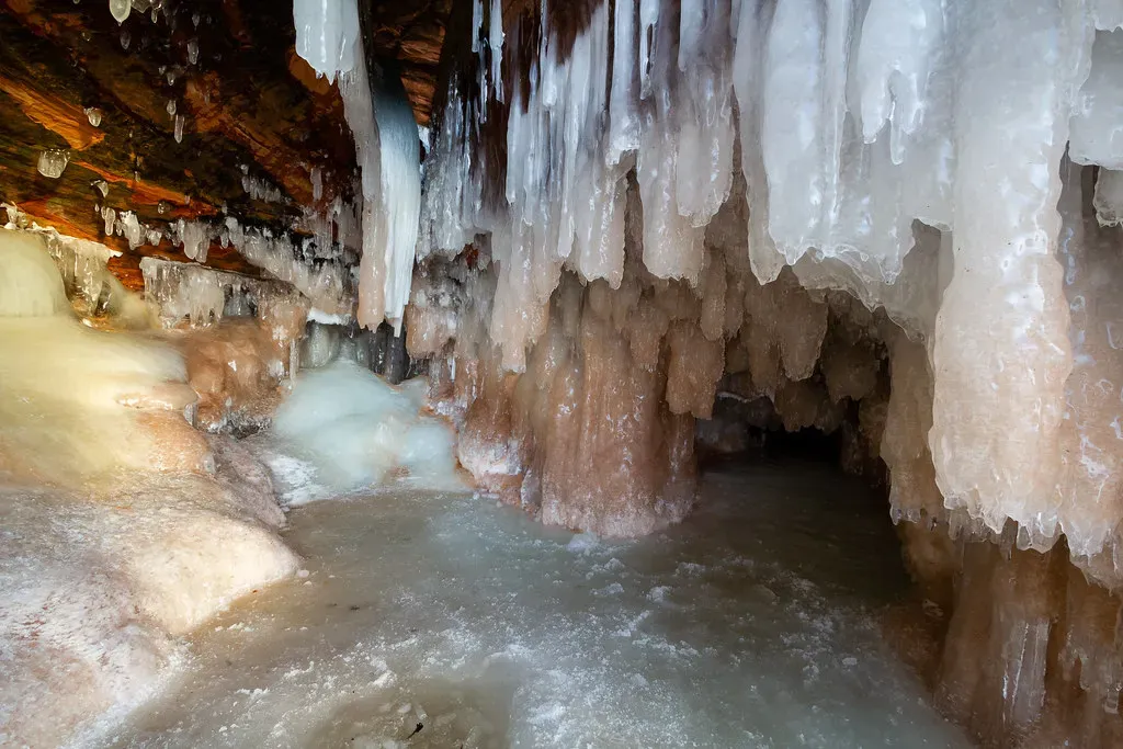
On the south shore of Lake Superior, the Apostle Islands sea caves show you what happens when soft sandstone, wild storms, and ancient ice team up. The cliffs here are part of the Bayfield Group, sandstones laid down by braided rivers and shallow water nearly a billion years ago, long before complex life crawled on land. Those layers vary in hardness, and the thinner, weaker beds of the Devils Island Formation are especially vulnerable to wave attack, which is why arches, honeycombed walls, and vaulted chambers have been carved into them over thousands of freeze-thaw cycles. ([nps.gov](https://www.nps.gov/apis/learn/nature/geologicformations.htm?utm_source=openai))
As you kayak beneath red overhangs in summer or hike the ice in a bitter winter, you are watching an ongoing tug-of-war between rock strength and lake power. Past glaciers excavated the basin of Lake Superior and stripped away debris, then as the ice melted and the crust rebounded, changing water levels exposed different bands of sandstone to wave energy. Every icicle dangling from a cave roof and every new fracture line you notice is proof that even old, supposedly solid rock is slowly being chewed into new forms by climate and water. ([nps.gov](https://www.nps.gov/apis/learn/nature/geologicformations.htm?utm_source=openai))
5. Guadalupe Mountains, Texas: A Fossilized Reef In The Desert
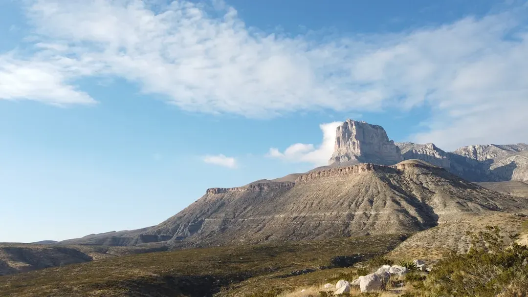
In far West Texas, the Guadalupe Mountains rise out of the Chihuahuan Desert like the spine of some buried creature, and in a sense that is exactly what they are. When you hike here, you are walking on the remains of a massive Permian-age reef that once rimmed a warm inland sea known as the Delaware Basin. What used to be a thriving community of sponges, algae, and other marine life is now hardened into limestone cliffs and canyons that tower above dry desert flats, giving you front-row access to a three-dimensional cross section of an ancient ocean. ([nps.gov](https://www.nps.gov/crmo/learn/education/geology-for-students.htm?utm_source=openai))
Over time, that reef was buried under additional sediments, then uplifted and tilted as tectonic forces stretched the region, allowing erosion to slice into it and reveal its skeleton. When you peer into canyon walls, you see fossil-rich layers that record subtle changes in sea level and water chemistry, a reminder of how sensitive marine ecosystems are to shifts in climate and geography. Standing on a desert ridge while picturing waves lapping at your feet drives home how dramatically coastlines can migrate when the planet’s conditions change. ([nps.gov](https://www.nps.gov/crmo/learn/education/geology-for-students.htm?utm_source=openai))
6. New Madrid Seismic Zone, Missouri Region: A Quiet Landscape Hiding Deep Faults
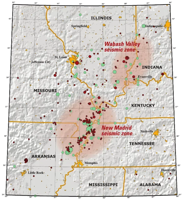
The flat fields and gentle riverbanks of the central Mississippi Valley feel about as far as you can get from a dramatic mountain range, yet you are standing over one of the most quietly troubling seismic zones in North America. The New Madrid Seismic Zone, centered in the Missouri–Arkansas–Tennessee region, produced a series of enormous earthquakes in the early nineteenth century that rattled church bells on the East Coast and permanently altered the course of the Mississippi River. When you drive across this region today, you see few obvious faults, but subtle low ridges, sunken areas called sand blows, and oddly bent river courses hint at buried structures in the crust. ([nps.gov](https://www.nps.gov/crmo/learn/education/geology-for-students.htm?utm_source=openai))
Unlike the flashy plate boundary faults out west, these faults cut through thick, ancient rocks deep beneath younger sediments, probably reactivating old zones of weakness as stress builds inside the plate. That makes this area a reminder that you cannot judge seismic risk only by how rugged the surface looks. If you pay attention to small details in the landscape, like uplifted terraces or ponds sitting in elongated depressions, you start to see how an apparently calm region can still carry the memory – and potential – of surprisingly powerful tectonic events. ([nps.gov](https://www.nps.gov/crmo/learn/education/geology-for-students.htm?utm_source=openai))
7. Valley of Fire State Park, Nevada: Frozen Sand Dunes In Flame Colors
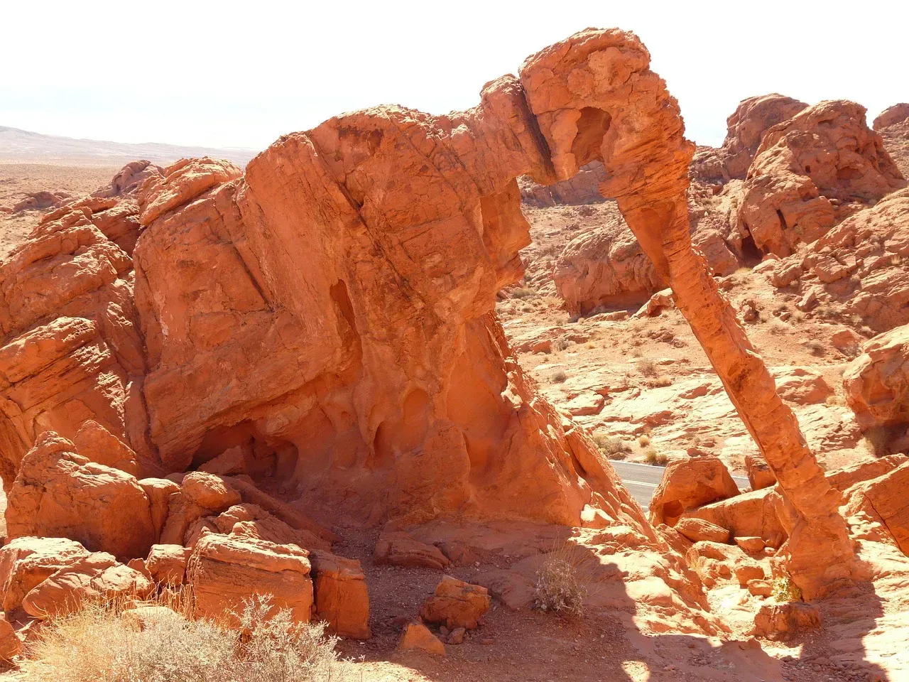
Just an hour or so from the bright lights of Las Vegas, Valley of Fire plunges you into a world of twisted red rock that looks like it was painted by a pyromaniac. Those flaming cliffs and domes are mostly Aztec Sandstone, the lithified remains of some of the largest sand dunes the continent has ever seen. As you walk up close, you can trace ancient dune cross‑beds – slanted layers that show you the direction the wind blew when this was an enormous desert in the Jurassic Period, at a time when dinosaurs would have left tracks across the same sands you now hike. ([nps.gov](https://www.nps.gov/crmo/learn/education/geology-for-students.htm?utm_source=openai))
Later, groundwater carrying dissolved minerals bled through the rock, staining some layers deep red while leaving others pale, and ongoing erosion carved the psychedelic shapes you see today. When you squeeze through a narrow slot or stand in the shade of a delicate arch, you are experiencing how rock that once felt endless and uniform has been selectively weakened along fractures and softer bands. The park quietly teaches you that even a desert landscape famous for dryness is really a story written by water and wind over immense stretches of time. ([nps.gov](https://www.nps.gov/crmo/learn/education/geology-for-students.htm?utm_source=openai))
8. Cape Blanco and The Southern Oregon Coast: Edges Under Constant Attack
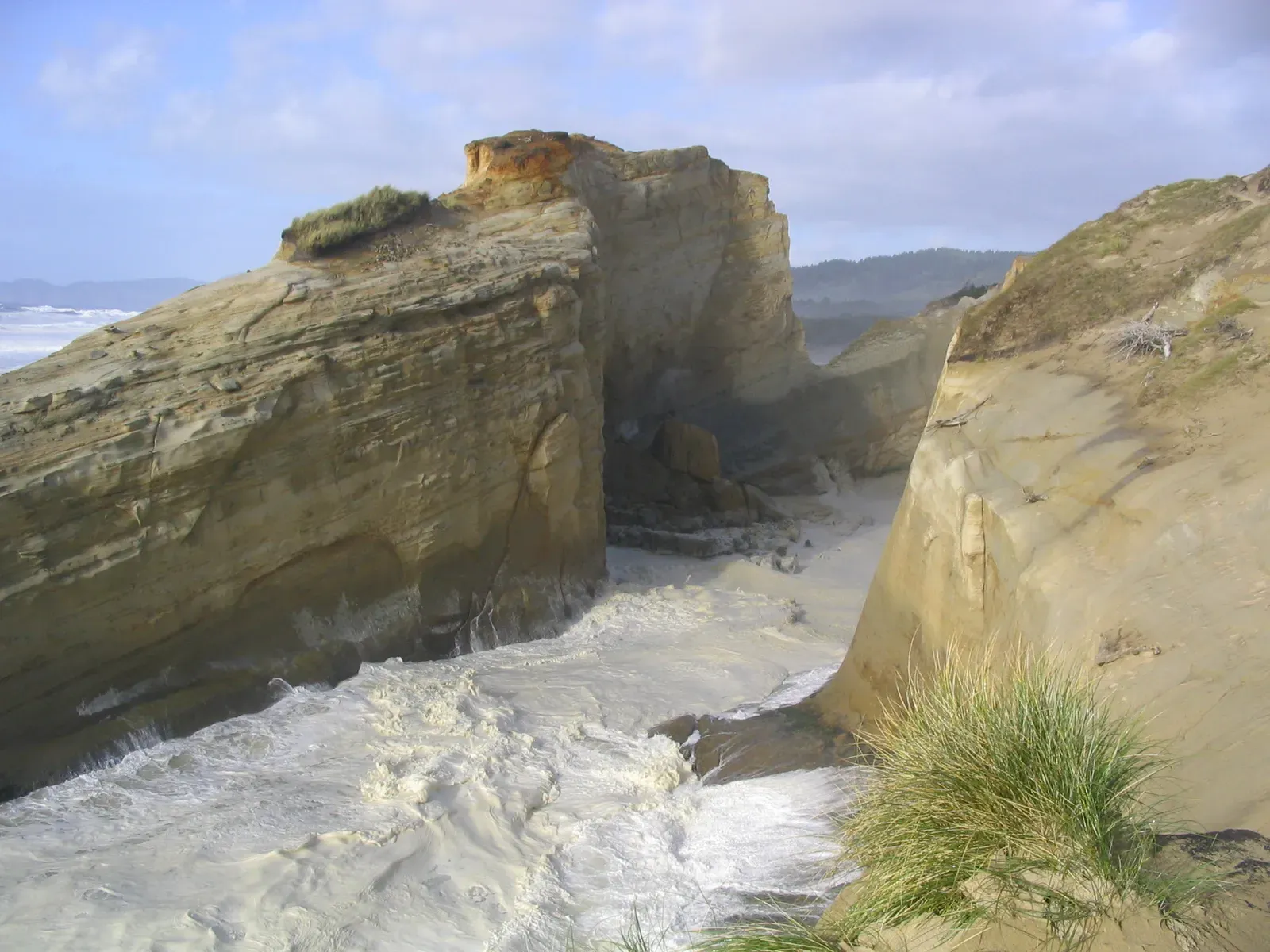
At first glance, the sea cliffs around Cape Blanco and the southern Oregon coast just look rugged and storm‑battered, but if you pay attention, you can watch continents eroding in real time. Here, layered sandstones, mudstones, and occasional volcanic rocks meet pounding Pacific waves and fierce winter storms that undercut slopes and trigger landslides. You see stacks and arches stranded offshore, remnants of headlands that used to be connected to the mainland before the sea carved them away grain by grain. ([nps.gov](https://www.nps.gov/crmo/learn/education/geology-for-students.htm?utm_source=openai))
This coastline also sits near the Cascadia Subduction Zone, where an oceanic plate dives beneath North America, slowly crumpling and uplifting the margin. Subtle marine terraces – flat benches cut by waves and then raised above sea level – tell you that the land has been heaving upward in fits and starts between big offshore earthquakes. When you stand on a high bluff listening to the surf, you are literally on the edge of a continent still being shaped by deep tectonic forces and relentless coastal erosion, a reminder that no shoreline is ever truly fixed. ([nps.gov](https://www.nps.gov/crmo/learn/education/geology-for-students.htm?utm_source=openai))
Conclusion: Seeing The Ground Beneath You With New Eyes
Once you have wandered places like Grand Staircase–Escalante, the John Day hills, or the black flows of Craters of the Moon, it gets harder to call geology “boring rocks.” You begin to feel that every ridge and gully is a frozen moment in an ongoing film, captured halfway between what was and what will be. Even in quiet farm country or along a forested lake shore, you start looking for tilted beds, odd landforms, or suspiciously straight valleys that whisper about buried faults and lost climates.
The real gift of these hidden geological sites is that they train you to read the planet, not just look at it. You realize that Earth is not a finished product but a restless, improvising system, and you are lucky enough to be here for a tiny slice of its performance. Next time you pass a road cut or stare out an airplane window, you might catch yourself wondering what story those layers would tell if you stopped to listen – what do you think you would see differently now that you know how much the ground remembers?