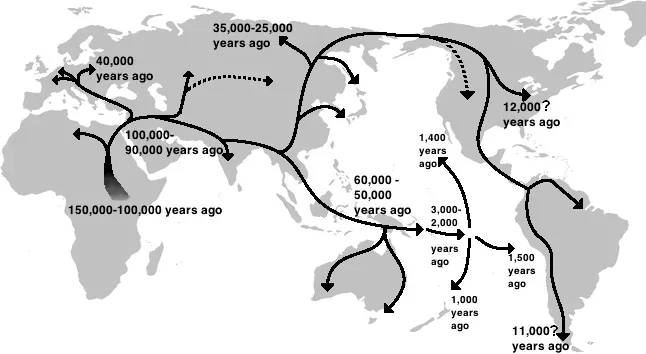
You’ve probably heard about the first people who arrived in the Americas, traveling from Asia thousands of years ago. What if the path they took wasn’t just a simple crossing, but an entire lost world that shaped the course of human history? The Bering Land Bridge has long fascinated archaeologists, geneticists, and climate scientists alike. This massive stretch of land, now submerged beneath the icy waters of the Bering Strait, held mysteries about how and when humans first made their way to North America.
New discoveries are turning long-held assumptions upside down. Recent research is revealing that the timeline of this ancient migration might be far more compressed than anyone imagined. With every sediment core pulled from the ocean floor and every genetic marker analyzed, we’re piecing together a story that’s both more complex and more thrilling than we ever thought possible. Let’s dive in.
When Did The Land Bridge Actually Appear?
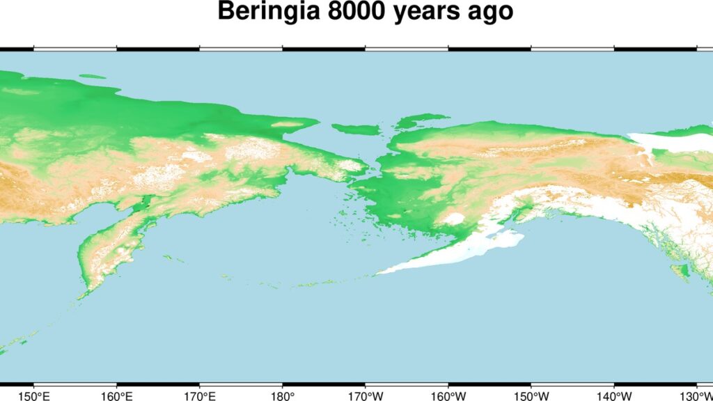
For decades, scientists believed the Bering Land Bridge emerged around seventy thousand years ago, staying open for tens of millennia. Recent data show that sea levels became low enough for the land bridge to appear only 35,700 years ago. This finding has sent shockwaves through the scientific community. Think about what this means: the window for humans to cross from Asia to the Americas suddenly got a lot narrower.
The new data reveal this emergence occurred at a time when global temperatures were relatively stable, raising questions about the correlation between temperature, sea level and ice volume. Here’s the thing: if climate wasn’t the only driver, then what else was at play? It seems that ice sheets can respond to forces beyond just warming and cooling cycles, adding layers of complexity to our understanding of Earth’s climate history.
How Human Migration Timing Just Got More Interesting
Genetic studies tell us that ancestral Native American populations diverged from Asian populations about 36,000 years ago, the same time that the Bering Land Bridge emerged. The coincidence is remarkable. What does this suggest? It hints that as soon as the land bridge opened, human populations seized the opportunity to move into new territory.
The finding raises questions about why humans decided to migrate as soon as the land bridge opened, and how humans made their way across the land bridge with no previous knowledge of the landscape. I know it sounds crazy, but imagine walking into completely uncharted territory, not knowing what lay ahead or what resources you’d find. Yet these ancient peoples did exactly that, driven by something we can only guess at. Perhaps following migrating herds, perhaps driven by population pressure, or maybe just that restless human curiosity that propels us into the unknown.
The Massive Scale Of Beringia
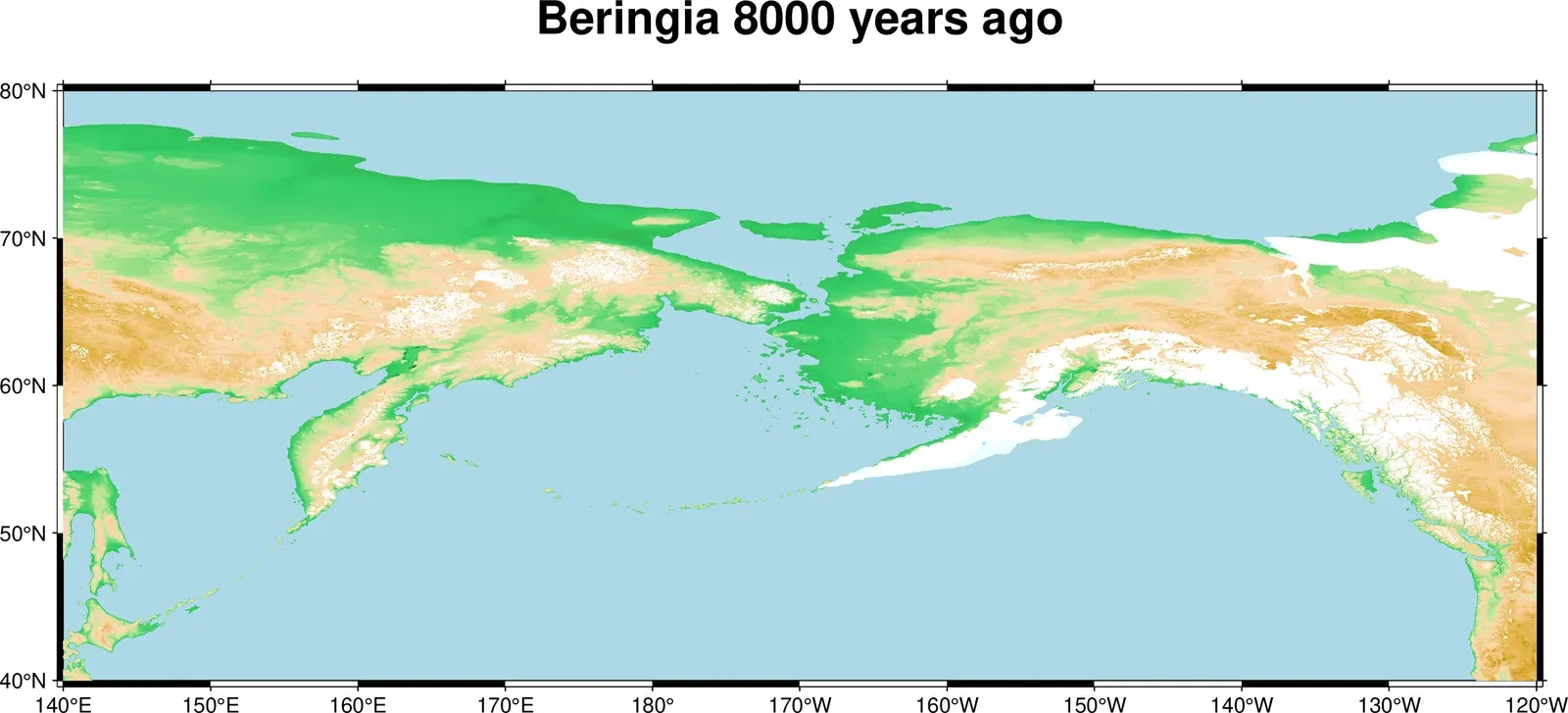
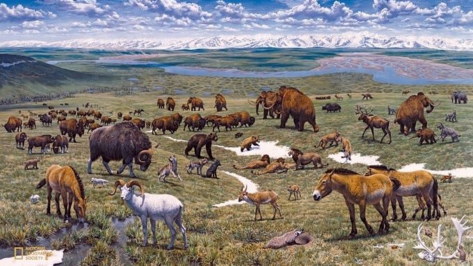
At its greatest extent, the Bering land bridge was up to 1,000 km wide and covered an area as large as British Columbia and Alberta together, totaling about 1.6 million square kilometers. This wasn’t just a narrow strip of exposed seabed. It was a vast territory, a subcontinent in its own right. Honestly, calling it a bridge doesn’t do it justice.
Beringia itself was not an inhospitable wasteland. Paleoecological studies suggest it was a patchwork of tundra, grasslands, and shrubs, providing adequate resources for survival. Mammoths, bison, horses, and caribou roamed across these windswept plains. For hunter-gatherer peoples adapted to harsh northern climates, Beringia would have been rich hunting ground. The landscape supported complex ecosystems that sustained both megafauna and the humans who depended on them.
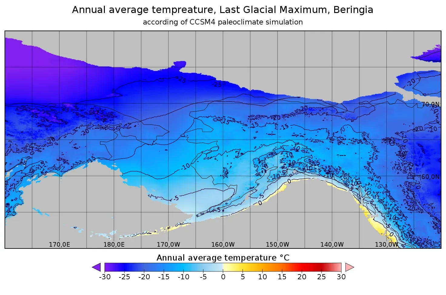
Climate’s Surprising Role In Opening And Closing The Gateway
Water levels in the Bering Strait helped drive global climate patterns during ice age episodes dating back more than 100,000 years. Let’s be real, most people think of the Bering Strait as a minor geographic feature. Yet this narrow passage wielded outsized influence over global climate systems. When it closed, it altered ocean circulation patterns that affected temperatures across entire hemispheres.
When the strait closed, circulation warmed Greenland and parts of North America by about 3 degrees Fahrenheit, enough to reverse the advance of ice sheets in those regions. Over thousands of years, this warming melted enough ice to raise sea levels and reopen the strait. Then the cycle repeated itself. It’s fascinating how this relatively small feature could trigger such cascading effects, creating a kind of climate pendulum that swung back and forth for millennia.
New Evidence From Arctic Ocean Sediments
Scientists are using innovative techniques to unlock the secrets buried in Arctic Ocean sediments. Analyses include looking at microfossils in the sediments including pollen grains and diatoms, evaluating the sediment chemistry, and looking for sedimentary ancient DNA bound to the sediments. These tiny fossilized remnants tell us what plants and animals existed on the now-submerged landscape. It’s hard to say for sure, but these cores might contain evidence of human activity that’s been underwater for more than ten thousand years.
These analyses will allow the team to identify plants and animals that were present on the low-lying Bering Land Bridge as well as to identify what types of wetlands were present, helping better understand conditions for animals and humans that migrated between Asia and North America thousands of years ago. Every sample provides another pixel in the larger picture. When you pull up mud from the sea floor and find traces of ancient pollen or DNA, you’re literally holding evidence of a lost world in your hands.
The Standstill Hypothesis And Genetic Mysteries
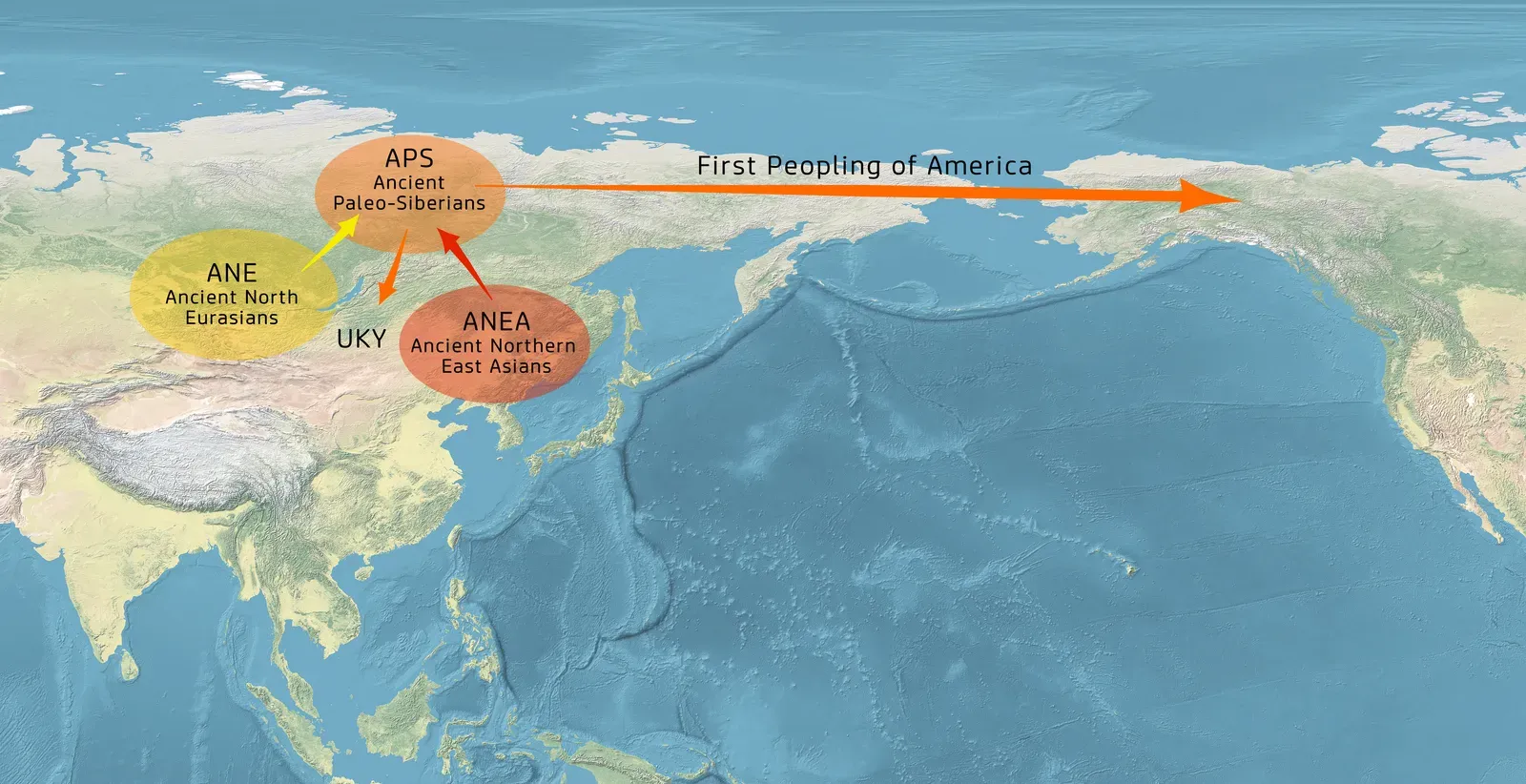
Some researchers propose that Beringia served as a temporary homeland for migrating populations, where humans lived for thousands of years before moving southward, a concept often called the “Beringian Standstill Hypothesis.” This theory suggests people didn’t just pass through quickly. They paused, adapted, and developed unique genetic signatures while isolated in this Arctic refugium.
The divergence between the Paleosiberians and the population that gave rise to the Beringians occurred approximately 24 thousand years ago, and the formation of Beringians, including Native American ancestors, began through interaction with newcomer East Asia-related peoples around 20 thousand years ago. The genetic evidence points to a complex mixing of populations in Beringia itself. These weren’t just migrants passing through. They were people who created new communities, adapted to extreme conditions, and eventually gave rise to the Indigenous peoples of the Americas. Their genetic legacy lives on in millions of people today.
Archaeological Footprints Of Ancient Beringians
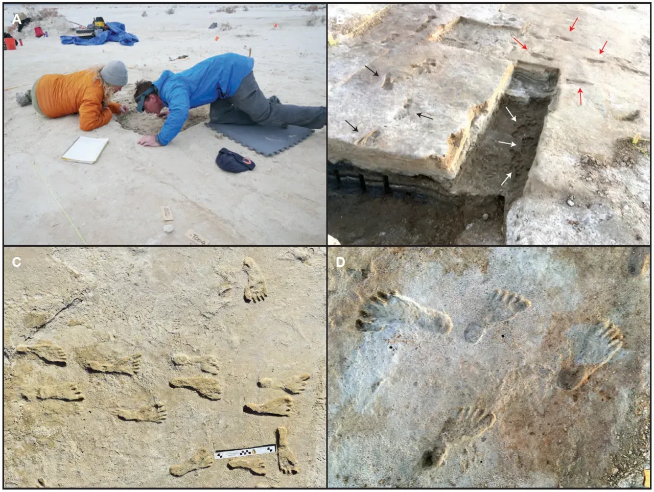
The earliest well-dated archaeological sites near the mouth of the Yana River have yielded thousands of stone and non-stone artifacts, and a large quantity of associated faunal remains, including steppe bison, reindeer, hare and mammoth, with dates concentrated around 34.5 to 31.5 thousand years ago. These sites provide tangible proof that humans thrived in some of the coldest, most challenging environments on Earth. The artifacts reveal sophisticated hunting strategies and tool-making techniques.
Analyses of biomarkers and microfossils suggest early humans burned Beringian landscapes as early as 34,000 years ago. The authors of these studies suggest that fire was used as means of hunting megafauna. Picture this: ancient hunters deliberately setting fires to drive massive herds of animals into kill zones. This wasn’t passive hunting. It was landscape management on a grand scale, demonstrating that these people possessed advanced ecological knowledge and sophisticated planning abilities. The idea that they simply wandered across looking for food doesn’t hold up anymore.
Looking Back From 2026: What We Now Understand
As we stand in 2026, the story of the Bering Land Bridge has been dramatically rewritten. The timeline has compressed, the complexity has increased, and our respect for the resilience and ingenuity of ancient peoples has deepened. The new findings are interesting in relation to human migration because they shorten the time between the opening of the land bridge and the arrival of humans in the Americas, though the timing of human migration into North America remains unresolved.
What once seemed like a straightforward migration story has become a multifaceted saga involving climate feedback loops, genetic adaptations, and human determination in the face of brutal Arctic conditions. Every discovery adds new dimensions to our understanding. The Bering Land Bridge wasn’t just a pathway. It was a crucible where modern human populations adapted to extreme northern environments, setting the stage for the peopling of an entire hemisphere.
Looking at the evidence now assembled from ocean sediments, genetic analysis, and archaeological excavations, we can see how this vanished land shaped not just migration routes but the very genetic makeup of millions of people living today. The ancestors who crossed Beringia carried with them adaptations forged in one of Earth’s harshest environments, adaptations that helped them succeed in populating two vast continents.
What do you think drove those first migrations across the exposed land bridge? Was it simply following food sources, or did ancient peoples possess a deeper sense of exploration that we can barely imagine today? The more we learn, the more questions emerge about the courage, adaptability, and vision of humanity’s ancient travelers.