You live on a planet that has been rebuilt over and over again by water you’ll never see. Long before modern rivers carved their familiar paths and today’s lakes filled their basins, vast prehistoric waters flooded continents, shifted climates, and quietly rewrote the rules of life on Earth. If you could peel back time like pages in an atlas, you’d see whole inland seas appearing, draining, and leaving behind new worlds for plants and animals to explore.
These ancient lakes and rivers were not just big puddles on a map; they were powerful engines of change. They steered the spread of species, created fertile soils that still feed people today, and even nudged global climate at critical moments. As you read through these eight examples, you’re really tracing the ghostly blue fingerprints of ancient climate swings, vanished ice sheets, and landscapes that would feel completely alien if you could stand there. And yet, their legacy is under your feet every day.
1. Lake Agassiz: The Freshwater Giant That Rewired North America
Imagine standing where the Red River Valley is today and seeing not farmland, but an inland sea stretching past the horizon in every direction. That was Lake Agassiz at its peak, a monstrous glacial lake formed as the Laurentide Ice Sheet melted at the end of the last Ice Age. Fed by torrents of meltwater, it expanded to cover a region bigger than all of today’s Great Lakes combined, spreading across what is now Manitoba, Ontario, Saskatchewan, Minnesota, and North Dakota. ([en.wikipedia.org](https://en.wikipedia.org/wiki/Lake_Agassiz?utm_source=openai))
As Lake Agassiz swelled and shrank through different phases, its spillways shifted, sending enormous floods south into the Mississippi system, east toward the Great Lakes, and northwest toward the Arctic. Each drainage event carved new channels, rearranged watersheds, and released huge pulses of freshwater into the oceans that may have disrupted ocean circulation and climate. When you look at the flat, fertile Red River Valley today, you are really seeing the old lake bottom – fine clays and silts laid down in quiet water that now act like a natural pantry for prairie agriculture. ([roadmarker.geosocmn.org](https://roadmarker.geosocmn.org/content/lake-agassiz?utm_source=openai))
2. Glacial River Warren: The Megaflood Channel Beneath Your Feet
Now picture what happened when that enormous Lake Agassiz finally found a lower exit. The result was Glacial River Warren, a short-lived but ferocious river that drained the lake between roughly thirteen and ten and a half thousand years ago. The flow was on a different scale from anything you know today: a torrent so large it scoured a wide valley across the Upper Midwest, far wider than the modern Minnesota River that now trickles along its floor. Where you see gently rolling farmland and bluffs, you are really standing in the scar left by catastrophic ice‑age plumbing. ([en.wikipedia.org](https://en.wikipedia.org/wiki/Glacial_River_Warren?utm_source=openai))
This prehistoric river acted like a conveyor belt, rushing water and sediment from the interior of the continent toward the Mississippi and ultimately the Gulf of Mexico. Along its route, it left terraces, boulder fields, and rich alluvial soils that set the stage for later ecosystems – prairies, hardwood forests, and eventually human settlements that took advantage of the wide valley and easy travel route. If you have ever driven across southern Minnesota and wondered why the river valley seems absurdly oversized, you are seeing the lingering footprint of River Warren’s ice‑age fury, long after the floodwaters disappeared. ([en.wikipedia.org](https://en.wikipedia.org/wiki/Glacial_River_Warren?utm_source=openai))
3. Paratethys: The Inland Sea That Became a Chain of Lakes
Shift your gaze to Eurasia and roll time back several million years, and you find Paratethys, a vast inland sea that once stretched from central Europe deep into western Asia. During the middle to late Cenozoic, it formed a shallow, mostly landlocked water body separated from the open oceans, making it more like a staggeringly oversized lake than a typical sea. At its greatest size, it covered a huge swath of what is now continental Europe and parts of Central Asia, easily ranking as the largest inland sea in Earth’s history. ([en.wikipedia.org](https://en.wikipedia.org/wiki/Paratethys?utm_source=openai))
As tectonic forces uplifted mountain ranges and sea connections narrowed, Paratethys gradually fragmented. Over millions of years, it broke up into a mosaic of basins that eventually gave rise to modern relics like the Black Sea, the Caspian Sea, and the Aral Sea. That slow dismembering created isolated habitats where fish, mollusks, and other organisms evolved in their own directions, leading to unique species lineages. When you look at today’s patchwork of brackish and saline seas across this region, you are really seeing the final, shrunken echoes of a single colossal water body that quietly shaped the biodiversity of an entire continent. ([en.wikipedia.org](https://en.wikipedia.org/wiki/Paratethys?utm_source=openai))
4. Lake Lahontan: The Desert Lake That Built a Hidden Wetland World

If you have ever driven through Nevada and thought the landscape looked hopelessly dry and empty, it might surprise you to know you are crossing the floor of a long‑vanished lake. During the last glacial period, Lake Lahontan filled much of what is now northwestern Nevada and parts of neighboring states. It rose hundreds of meters deep in places and spread across multiple sub‑basins, creating a cool, wetter world where shorelines wrapped around mountains and bays extended into valleys that are now bare desert. ([en.wikipedia.org](https://en.wikipedia.org/wiki/Lake_Lahontan?utm_source=openai))
As climate warmed and dried, Lake Lahontan retreated, leaving behind stranded shorelines etched into hillsides, thick piles of lake sediments, and isolated remnants like modern Pyramid Lake and Walker Lake. Those remnants still support distinctive desert aquatic ecosystems, with fish and bird communities that rely on the last scraps of the old lake. When you see those sharp bathtub rings on Nevada’s slopes, you are reading an old water level record carved in stone – a reminder that today’s dry basins were once busy hubs of wetlands, spawning grounds, and migration stopovers for wildlife crisscrossing Ice Age North America. ([en.wikipedia.org](https://en.wikipedia.org/wiki/Lake_Lahontan?utm_source=openai))
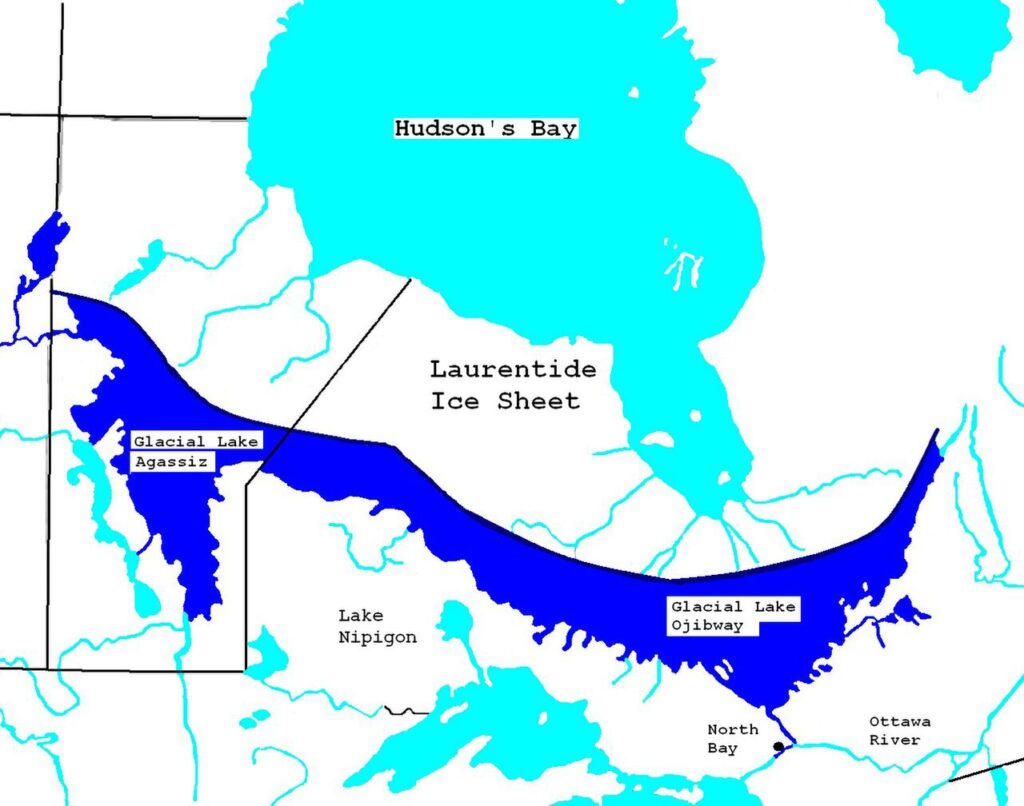
5. Lake Ojibway: The Northern Floodgate With Global Reach
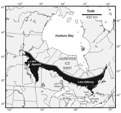
Farther east in Canada, another enormous glacial lake waited behind retreating ice: Lake Ojibway. Formed in what is now northern Ontario and Quebec, it pooled meltwater along the western edge of the waning Laurentide Ice Sheet and may have been roughly comparable in size to a late phase of Lake Agassiz, with which it was likely connected. Around eighty‑five hundred years ago, this combined system reached its maximum, storing staggering amounts of fresh water in a landscape that is now largely boreal forest and muskeg. ([en.wikipedia.org](https://en.wikipedia.org/wiki/Lake_Ojibway?utm_source=openai))
When those lakes finally drained catastrophically toward Hudson Bay and the North Atlantic, they unleashed a massive freshwater pulse into the ocean. Many researchers think that sudden outflow may have disrupted ocean circulation patterns and nudged regional climates, particularly in the North Atlantic realm. For ecosystems, the story runs deeper than one big flood: the periodic rise and fall of these lakes created shifting mosaics of shorelines, wetlands, and river connections where fish, birds, and mammals could move, adapt, or vanish. If you walk the low, flat terrain of northern Canada today, it can feel monotonous – but hidden in the topography and sediments is the record of a dynamic lake landscape that flickered on and off in geologic moments. ([en.wikipedia.org](https://en.wikipedia.org/wiki/Lake_Ojibway?utm_source=openai))
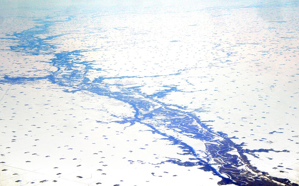
6. The West Siberian Megalake: A Hidden Giant Beneath the Taiga
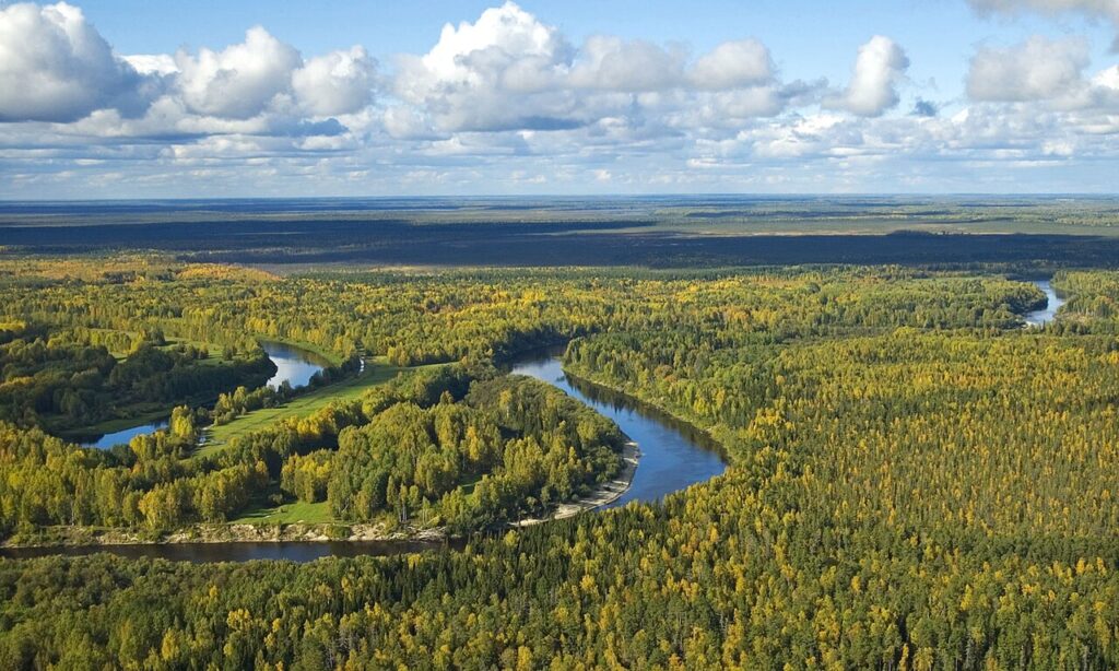
Cross the Arctic Circle into Siberia in your mind, and you find another Ice Age titan: a huge proglacial lake or series of lakes that once filled parts of the West Siberian Plain. Here, meltwater from northern ice sheets and dammed river systems gathered in one of the world’s flattest regions, creating a broad inland water body whose exact shape and timing are still actively studied. Geologists have traced ancient shorelines, stranded deltas, and lacustrine sediments that point to a much wetter past beneath the forests and bogs you see now. ([livescience.com](https://www.livescience.com/2861-huge-ancient-lake-discovered-russia.html?utm_source=openai))
For ancient ecosystems, this West Siberian Megalake acted like a massive sponge and mixing zone. It captured sediment and nutrients from vast river catchments, provided habitat for cold‑adapted fish and waterbirds, and connected drainage basins that are now separate. As the lake system drained and fragmented, it left behind peatlands, floodplains, and river networks that would become crucial corridors for plants, animals, and eventually human groups moving across northern Eurasia. The modern patchwork of wetlands and sluggish rivers still reflects that watery inheritance, like a faded watermark on today’s landscape. ([livescience.com](https://www.livescience.com/2861-huge-ancient-lake-discovered-russia.html?utm_source=openai))
7. Paleo‑Lake Mega‑Chad: Africa’s Inland Sea of Life
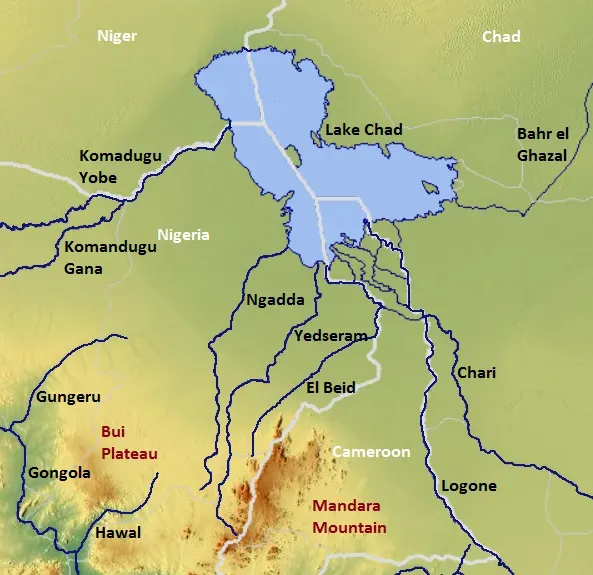
Turn your attention to the southern Sahara, and the transformation is almost shocking. Where you now picture dry sand and sparse scrub, repeated humid phases over the last several hundred thousand years filled the Chad Basin with a lake so large it is often called Mega‑Chad. At its maximum, this prehistoric lake spread across large areas of Chad, Niger, Nigeria, and Cameroon, turning what is now the edge of the desert into a shallow inland sea dotted with islands, deltas, and extensive wetlands. ([reddit.com](https://www.reddit.com/r/geology/comments/1ko4ozg?utm_source=openai))
In those wetter periods, you would have seen hippos, crocodiles, fish, and waterbirds thriving where dunes later marched in. The lake transformed the region into a biodiversity hotspot and a migration corridor, linking central African river systems and providing resources for early human populations who followed shorelines rich in fish and game. As climate oscillated, Mega‑Chad repeatedly grew and shrank, leaving behind beach ridges, fossil river channels, and fertile lowlands that still influence where people farm and graze animals today. Modern Lake Chad is only a tiny remnant, but its fluctuating waters continue the ancient pattern of boom‑and‑bust wet phases that once powered immense ecosystems. ([reddit.com](https://www.reddit.com/r/geology/comments/1ko4ozg?utm_source=openai))
8. The Okavango Paleo‑Megafan: A Fossil Blueprint for a Living Delta
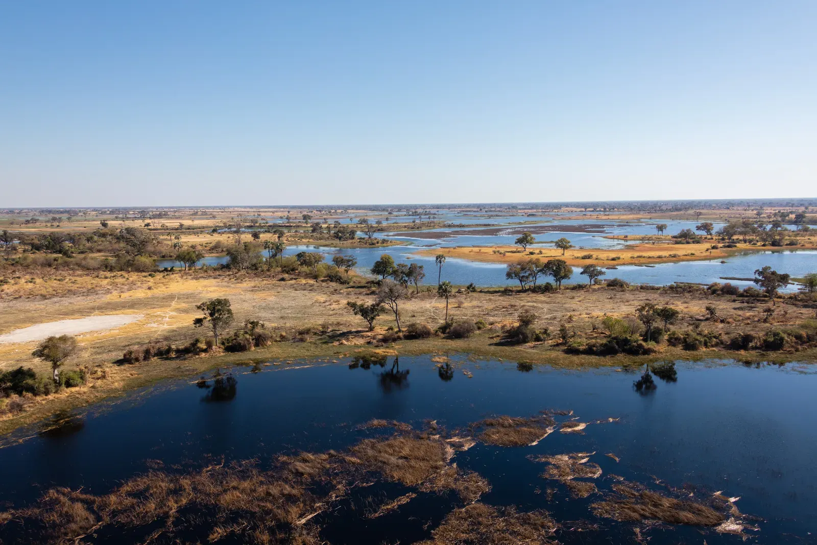
When you look at today’s Okavango Delta in Botswana – a lush fan of channels and wetlands spilling into the Kalahari – you are really seeing the latest chapter of a long story written by older river systems. Geological and remote‑sensing studies reveal that in the northern Kalahari Basin there are giant fossil megafans, including an ancient Okavango megafan stretching roughly one hundred and fifty kilometers or more. These prehistoric river‑built fans formed when rivers carried water and sediment far into what is now semi‑arid interior, creating broad, seasonally wet landscapes where life could flourish despite an otherwise dry climate. ([ntrs.nasa.gov](https://ntrs.nasa.gov/api/citations/20160010182/downloads/20160010182.pdf?utm_source=openai))
Those paleo‑megafans pre‑structured the basin, carving subtle slopes and sediment patterns that still guide the modern Okavango’s channels and wetlands. For ancient ecosystems, the fans acted like enormous green carpets rolled out into the desert, supporting grasses, woodlands, and a riot of herbivores and predators, much like the wildlife spectacle you associate with the region today. As climate and tectonics shifted, old channels dried up or were abandoned, but their ghost outlines remain in the subsurface. When you watch a satellite image of seasonal floods pulsing through the Okavango, you are really seeing water reoccupy a space that rivers have been experimenting with for hundreds of thousands of years. ([ntrs.nasa.gov](https://ntrs.nasa.gov/api/citations/20160010182/downloads/20160010182.pdf?utm_source=openai))
Conclusion: Reading the Ghost Rivers Beneath the Modern World
When you stitch these stories together, a clear pattern emerges: prehistoric lakes and rivers were not just background scenery, they were the main architects of the landscapes and ecosystems you see now. Each giant water body – whether it was Agassiz spreading over the northern plains, Paratethys draping itself across Eurasia, or Mega‑Chad filling the Sahara – created temporary worlds of shorelines, deltas, and migration corridors. As they drained, fragmented, or shrank, they left behind fertile soils, rearranged river networks, and genetic highways that plants, animals, and people used to move and adapt. You live with the consequences every time a river follows an oddly oversized valley or a productive farming region sits on suspiciously flat, silty ground.
Thinking this way changes how you see your own surroundings. That quiet prairie, that dusty basin, that meandering river might all be shadows of much wilder water stories that played out long before your species arrived. By paying attention to ancient shorelines, fossil deltas, and buried megafans, you gain a kind of x‑ray vision for Earth’s past and a deeper respect for how quickly environments can flip from desert to inland sea and back again. The real question is: now that you know how radically water has reshaped the planet before, how do you imagine today’s lakes and rivers will sculpt the world you leave to the future?