If you think archaeology is about steadily solving mysteries one neat layer at a time, these sites will shake that belief. Again and again, archaeologists went in expecting answers, only to walk away with even bigger questions, stranger timelines, and evidence that just did not fit the tidy narratives in our textbooks. In a few cases, the first shovelfuls of soil seemed reassuringly normal – then deeper trenches, better dating techniques, or wider surveys ripped the floor out from under earlier explanations.
What makes these places so gripping is not wild speculation about lost super-civilizations or aliens, but the opposite: the hard, stubborn data that keeps refusing to behave. Radiocarbon dates collide with assumptions about when humans could build certain things. Monumental structures show up where there is supposed to be nothing but small villages. Entire cities vanish from the record with almost theatrical drama. Let’s walk through ten sites where the more we learned, the less comfortable the story became – and where, even in 2026, honest archaeologists have to admit that some parts simply do not make sense yet.
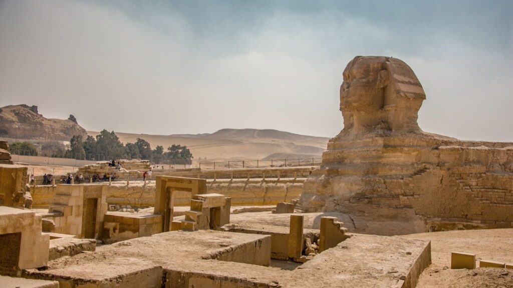
Göbekli Tepe, Turkey: A Monumental Temple Before Farming
Imagine assuming you know roughly when large religious monuments first appeared – then finding out you were off by several thousand years. That is exactly what happened with Göbekli Tepe, a hill in southeastern Turkey that excavators initially thought was just another modest mound. Once systematic digging began in the 1990s, researchers uncovered massive T‑shaped stone pillars arranged in circular enclosures, carved with foxes, snakes, birds, and other animals, and firmly dated to the early pre‑pottery Neolithic, long before settled farming villages were expected to exist in that region.
The deeper excavations went and the more structures they mapped, the worse things got for the standard story. Instead of a small shrine attached to an early village, Göbekli Tepe appears to be a large communal ritual complex used by hunter‑gatherer groups, then deliberately buried on purpose over time rather than simply abandoned. That flips the old idea that religion and monuments came after agriculture, suggesting instead that shared ritual might have been a driving force that pulled people into larger, more organized communities. Every new building uncovered on the hill seems to intensify that puzzle, not settle it.
Yonaguni Monument, Japan: Natural Rock or Drowned Architecture?
When divers first documented the stepped, terrace‑like formations off Yonaguni Island in the 1980s, it looked temptingly like a submerged stone complex: broad platforms, straight edges, what seemed like staircases and sheer walls. At first glance, it was easy to imagine a sunken city or ceremonial pyramid swallowed by rising seas at the end of the last Ice Age. The problem is that the more geologists and archaeologists have examined Yonaguni, the harder it has become to pin it down as either fully natural or clearly human‑made.
Field studies of the island’s geology show that the underwater structures line up closely with natural sandstone bedding planes and fractures, and the majority of specialists lean toward a natural origin shaped by erosion, waves, and tectonics. At the same time, the monument’s uncanny regularity, sharp angles, and resemblance to deliberately cut terraces keep fueling arguments that people at least modified the formation. No tools, artifacts, or cultural layers have been securely tied to the site, which is a crucial missing piece. So Yonaguni sits in a frustrating gray zone: too geometric for many to accept as random geology, yet too archaeologically “empty” to be recognized as a confirmed ruin.
Puma Punku, Bolivia: Precision Stonework Without a Clear Blueprint
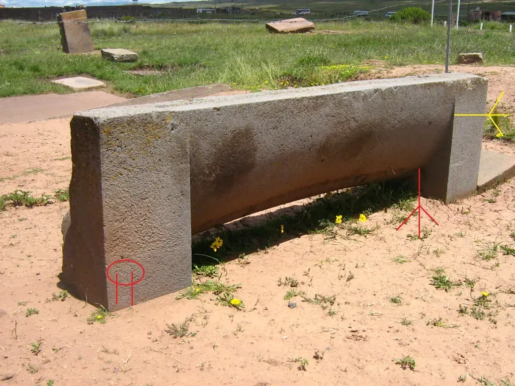
Puma Punku, part of the Tiwanaku complex high on the Andean altiplano, is one of those places that looks deceptively simple in photos and utterly baffling up close. Early explorers already knew they were looking at a collapsed monumental platform, but excavation and careful mapping revealed something stranger: huge multi‑ton blocks with intricate recesses, grooves, and near‑perfect right angles, some of which interlock in ways that feel almost like a stone version of modular furniture. Radiocarbon dating and stratigraphy tie major construction phases to roughly the first millennium of the Common Era, well within the known timeline of the Tiwanaku culture.
So why did more excavation make it harder to explain? Because as archaeologists recovered more blocks and fragments, they realized how systematically the pieces fit together, yet they still lacked evidence for the full original layout or clear traces of the tools and methods used. We know pre‑Columbian Andean societies were capable of sophisticated masonry using stone tools, abrasives, and clever engineering, so there is no need to invoke exotic technology. But Puma Punku’s level of precision, combined with its abrupt partial destruction and abandonment, makes it an outlier even within its own cultural tradition. The site keeps forcing a more nuanced picture of what Andean builders could do – and why they did it in this one particular place.
Nabta Playa, Egypt: Stone Circles in the Pre‑Desert
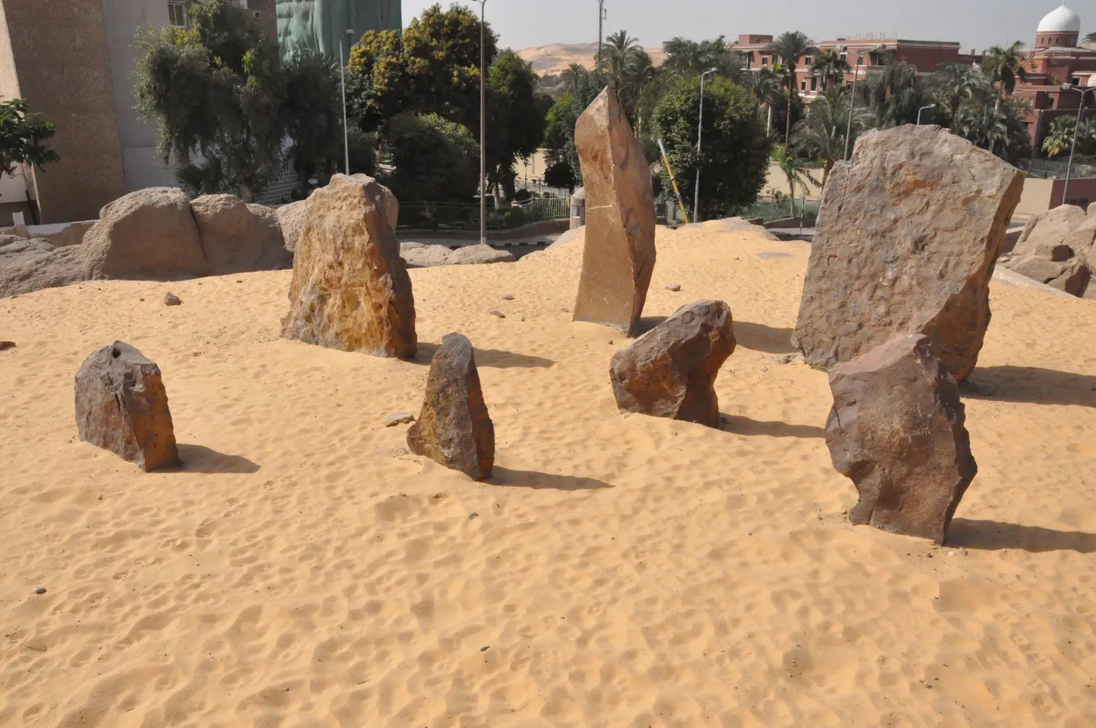
Long before the familiar temples and pyramids rose along the Nile, seasonal communities were gathering deep in what is now the Egyptian Sahara at a site called Nabta Playa. Initial surveys spotted scattered stone circles and alignments around an ancient lake bed, which were intriguing but not shocking. As excavation and dating progressed, though, it became clear that some of these features were much older than Egypt’s dynastic monuments, belonging to early pastoralists more than six thousand years ago who were herding cattle and practicing complex rituals in a harsh, shifting environment.
The more data came in, the more questions multiplied. Some stone arrangements appear to line up with solstices or particular star risings, leading to cautious arguments that these communities were tracking the sky with impressive precision for mobile herders. But the evidence is patchy and the alignments are debated, and it is easy to over‑interpret a few plausible lines on the horizon. What Nabta Playa definitely does show is that ritualized landscapes and possibly astronomical awareness emerged far from river valleys and kings, among people whose material remains are otherwise modest. That realization has forced archaeologists to rethink where and how complex symbolic behavior should appear in early North Africa.
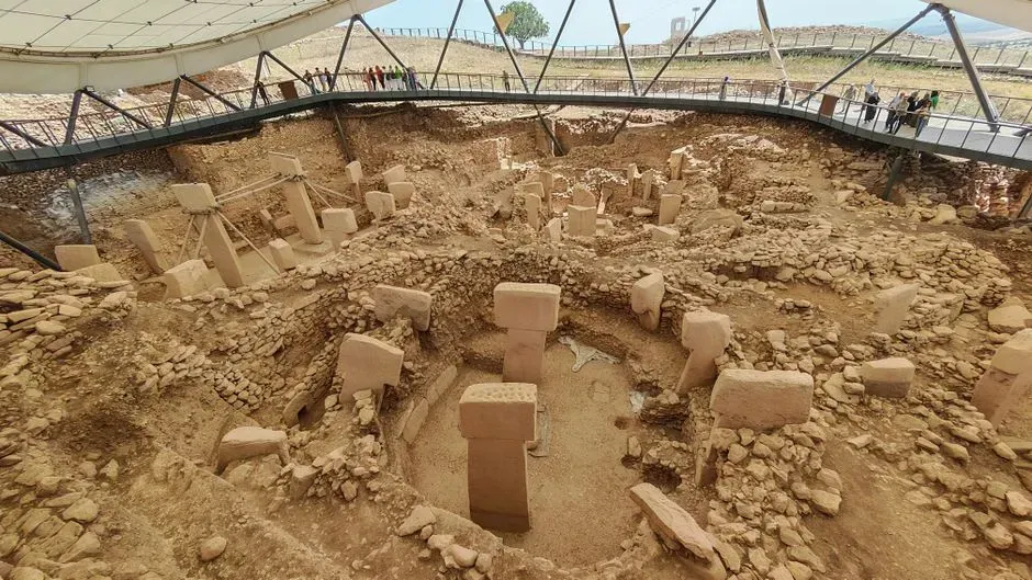
Çatalhöyük, Turkey: A City Without Streets or Obvious Hierarchy
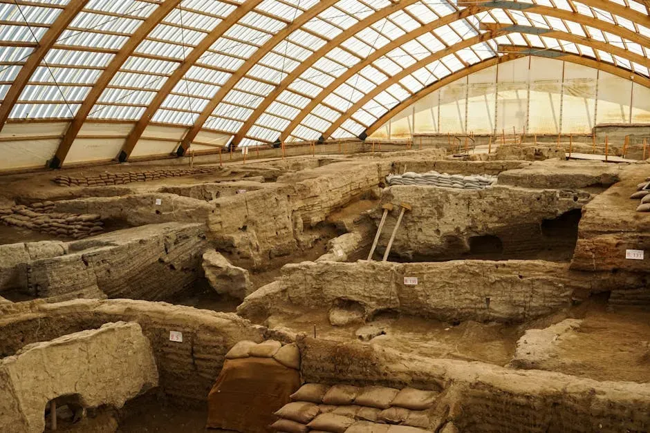
When excavations began at Çatalhöyük in central Turkey in the 1960s, the site was already recognized as a very large Neolithic mound. Early trenches suggested a dense settlement of mudbrick houses dating back more than eight thousand years, which was exciting but still just within the expected arc from small farming villages to early towns. As decades of fieldwork unfolded, however, a more unsettling picture emerged: a sprawling, tightly packed “city” with no streets, no clear public buildings, and a social structure that stubbornly refuses to fit simple models of chiefs and elites.
Residents apparently moved across rooftops and entered homes via ladders, with domestic and ritual life woven together inside similar‑looking buildings. Burials, wall paintings, and symbolic objects turn up across many houses rather than being restricted to obvious temples or palaces. As more of the site has been exposed, archaeologists have found variation and complexity but not the neat spatial hierarchy many expected. That has made Çatalhöyük one of the most uncomfortable case studies for the idea that urbanism inevitably comes packaged with clear social ranking and monumental architecture. Instead, it points to a messier spectrum of ways large communities can organize themselves.
Sacsayhuamán, Peru: Cyclopean Walls and Missing Context
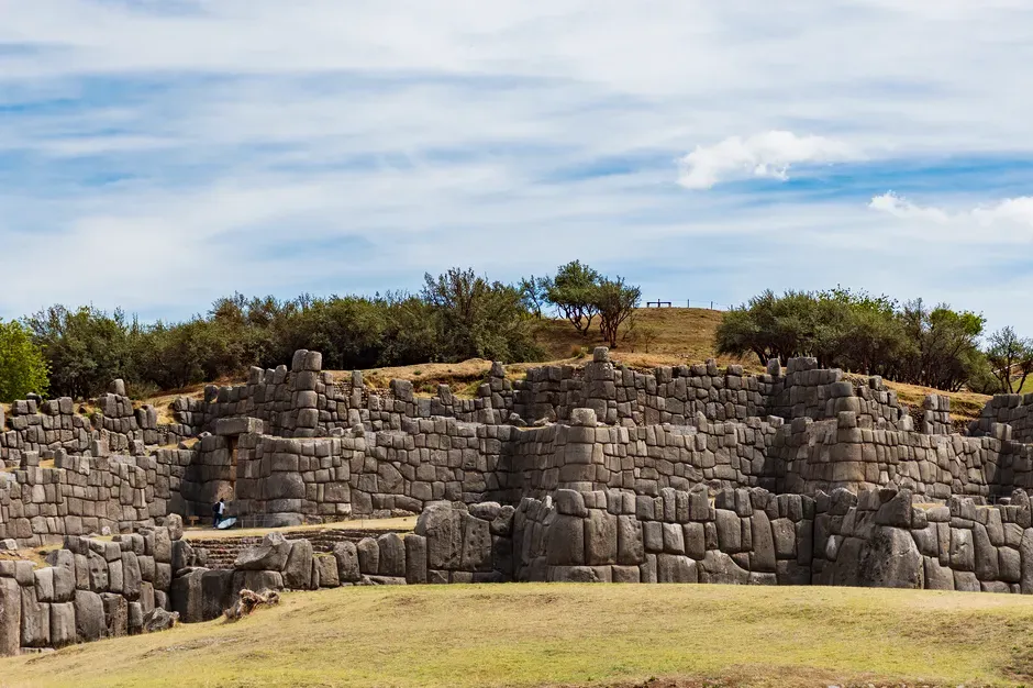
Overlooking the modern city of Cusco, the fortress‑like complex of Sacsayhuamán was already impressive in colonial accounts: huge zigzagging walls of carefully fitted stone forming a massive terrace system. Initial archaeological work confirmed that the Inca used and expanded the site, tying it into their political and ceremonial capital. That seemed straightforward enough. Then excavations and architectural studies started revealing earlier construction phases and subtle differences in masonry styles that hinted at a deeper, layered history not easily pinned to a single builder.
The biggest headache is the combination of extreme precision and incomplete context. Many of the largest blocks weigh dozens of tons, fitted together without mortar in complex patterns that resist easy reconstruction of the building sequence. At the same time, the Spanish conquest and later quarrying stripped away upper structures and associated material culture that might have clarified the original functions. As archaeologists have peeled back more of the hilltop, they have gained tantalizing evidence for long‑term ceremonial use but no simple, settled explanation for how the labor was organized over time or why particular parts of the complex were built in such dramatically over‑engineered ways.
Stone Spheres of Costa Rica: Perfect Shapes, Elusive Purpose
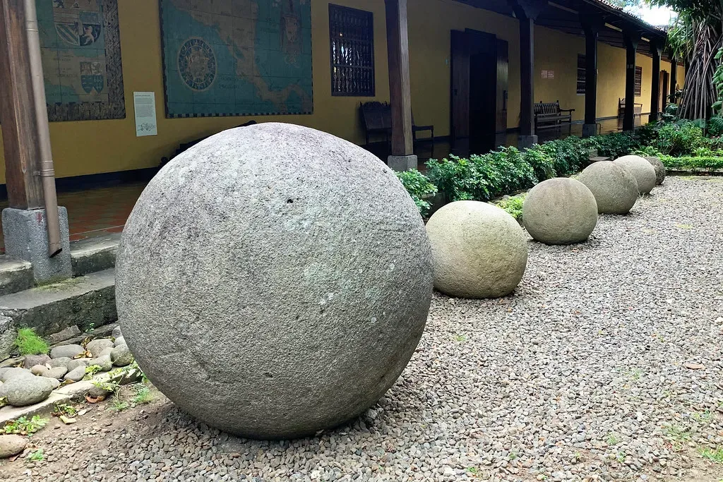
The stone spheres of Costa Rica were not excavated all at once; many were unearthed accidentally during twentieth‑century banana plantation work in the Diquís Delta. Early reports described them as almost eerily round, with some measuring more than two meters in diameter. When archaeologists began documenting them more systematically, they hoped that careful excavation around in‑situ examples would reveal clear patterns: alignment with buildings, association with elite burials, or consistent placement in plazas that would point to a shared symbolic system.
Instead, later digs often turned up scattered contexts, disturbed settings, and frustrating ambiguity. Some spheres are found near mounds or architectural features, others alone, and many had been moved long before scientific documentation. Radiocarbon dating of nearby materials suggests a pre‑Columbian origin over several centuries, but not a single tight moment where a single culture spread them like a signature. The better we know their distribution, the harder it is to argue for one tidy explanation – be it astronomical markers, territorial symbols, or status objects. They have become a prime example of how archaeological visibility does not always translate into interpretive clarity.
Derinkuyu and the Cappadocian Underground Cities, Türkiye
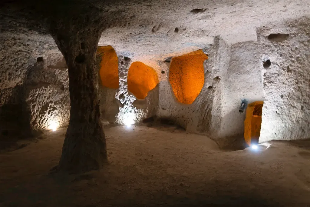
When local people in Cappadocia expanded basements and storage rooms and accidentally punched through into hidden tunnels, they were not expecting to reveal a vast underground world. Early explorations of places like Derinkuyu showed multilevel networks of rooms connected by passageways, with ventilation shafts and massive rolling stone doors. Initially, it was tempting to see them as purely Byzantine or early medieval refuges, dug in response to specific waves of conflict. As archaeologists continued to map deeper levels and compare architectural details across the region, though, the story became far more layered.
Multiple construction and reuse phases suggest these complexes were expanded and modified over many centuries, likely beginning in pre‑Christian times and continuously adapted for storage, refuge, and perhaps even seasonal occupation. Yet secure dates for the earliest excavations into the soft volcanic tuff remain patchy, and clear inscriptions or artifacts tying specific rooms to specific eras are rare. The more tunnels and chambers get cleaned and surveyed, the more obvious it becomes that no single explanation – whether “war refuge,” “monastic retreat,” or “hidden city” – captures their full history. They force archaeologists to accept a long, messy evolution of use that we may never fully reconstruct.
Rujm el‑Hiri (Gilgal Refaim), Golan Heights: Concentric Rings Without a Clear Story
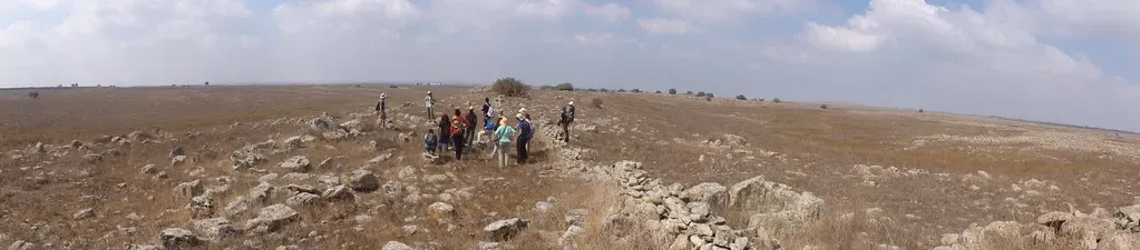
From the air, Rujm el‑Hiri looks like a prehistoric crop circle in stone: multiple concentric rings of basalt rocks surrounding a central mound on a lonely plateau. Ground surveys and excavations in the late twentieth century revealed that the structure is genuinely ancient, built in the Bronze Age by pastoral or semi‑sedentary communities who hauled a staggering amount of stone to create it. At first, some archaeologists hoped it would turn out to be a straightforward ceremonial center or burial complex with a recognizable pattern from other sites in the Levant.
Instead, deeper work revealed stratified use over centuries, ambiguous burial evidence, and possible astronomical alignments that are intriguing but debated. Some researchers argue that sightlines from specific points match solstice sunrises, while others caution that with so many stones and potential viewpoints, it is easy to find patterns that may be coincidental. The central cairn added later only complicates the phasing. In the end, Rujm el‑Hiri has become one of those sites where every new trench answers a technical question – how stones were piled, how layers relate – while leaving the big “why” stubbornly unresolved.
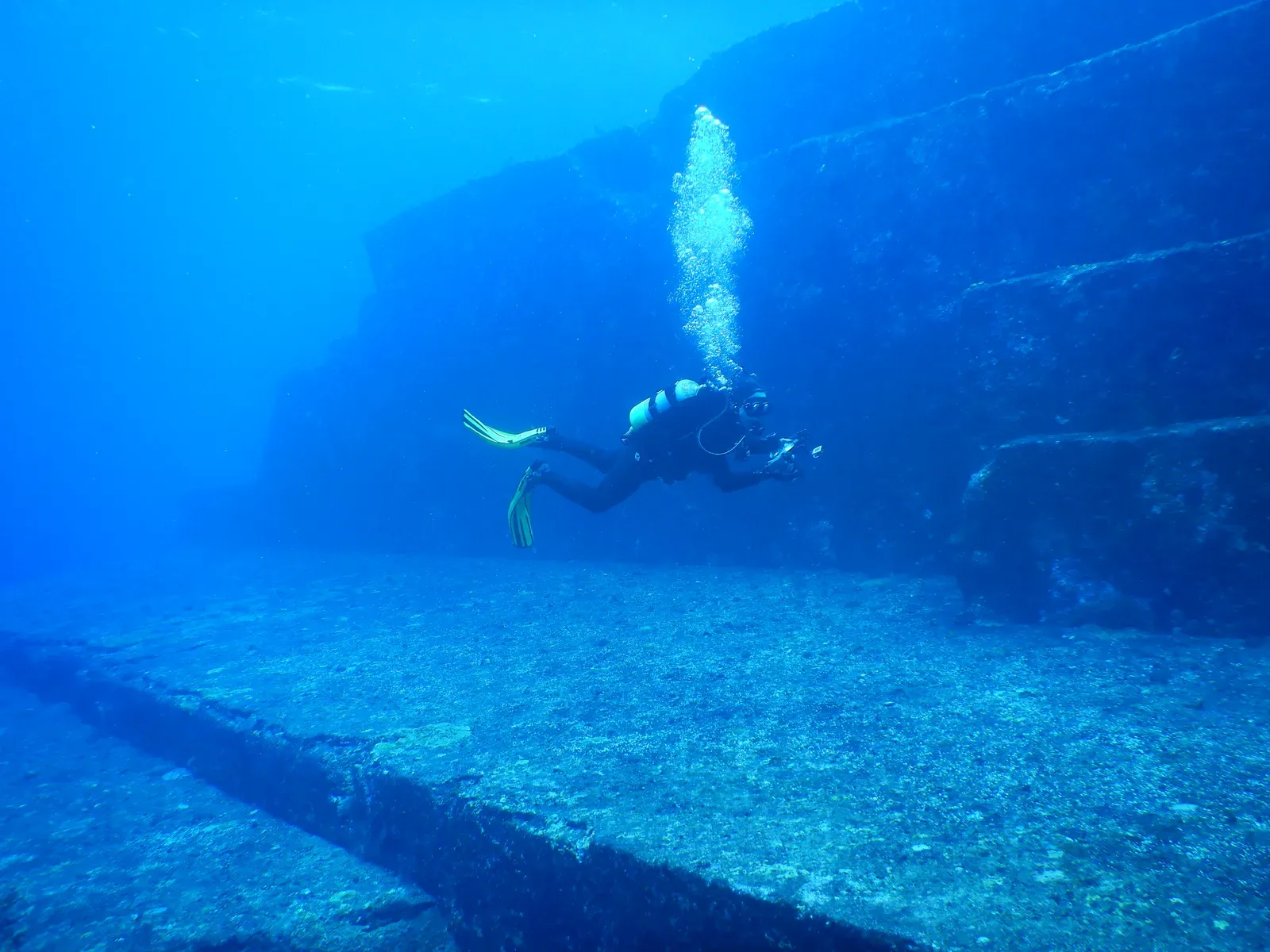
Heracleion (Thonis), Egypt: A Lost Port City That Won’t Sit Still
For centuries, Heracleion was basically a rumor in classical texts and scattered inscriptions, a trading hub somewhere near the mouth of the Nile that had supposedly sunk beneath the sea. When underwater archaeologists actually found its ruins in Aboukir Bay, it felt like a triumph of scholarship: a legendary city confirmed. Early mapping of monumental statues, sphinxes, stelae, and harbor installations seemed to support the idea of a single thriving port that met a dramatic end, perhaps in an earthquake or sudden subsidence.
As more seasons of underwater excavation and survey have unfolded, however, the picture has turned increasingly tangled. Instead of a neatly bounded city, the area contains overlapping harbor basins, religious structures, and shipwrecks spanning several centuries, all affected by gradual subsidence, Nile channel shifts, and multiple flood events. Distinguishing between one “city” and a broader, evolving port landscape has become a challenge, and so has tying specific destruction layers to specific historical episodes. Heracleion now functions as a cautionary tale: even when you finally find the lost city you were looking for, its archaeological reality might refuse to match the crisp narrative you had in mind.
Conclusion: When the Ground Refuses to Play Along
What ties all of these sites together is not secret knowledge or suppressed discoveries, but the opposite: an honest admission that the evidence is messy, incomplete, and sometimes deeply awkward for our favorite tidy timelines. I find that strangely reassuring. It means archaeology is still alive, still willing to have its stories overturned by a stubborn pillar, a confusing date, or a site plan that simply will not behave. In my view, the biggest lesson from Göbekli Tepe, Yonaguni, Puma Punku, and the rest is that we are probably underestimating both how inventive past people were and how weird natural processes can be.
Personally, I think the most responsible stance is a mix of humility and curiosity: reject the easy fantasies, but also stop pretending our current models are final. The more carefully we excavate and the more precise our dating and mapping become, the more we should expect to be surprised – and sometimes embarrassed – by what turns up. Maybe that is the real thrill here: not that these places hint at impossibilities, but that they keep reminding us how small our window onto the past really is. When you look at these ten sites, which puzzles do you think will still be unsolved fifty years from now, and which might suddenly make sense with one new layer of evidence?