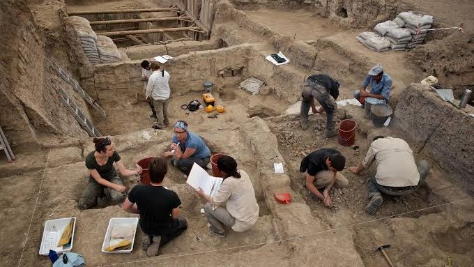
For most of human history, our ancestors’ journeys were invisible lines, lost to time and imagination. We had bones in caves, stone tools in riverbeds, and a few scraps of ancient DNA, but the actual paths people walked remained hazy guesses drawn on speculative maps. Only in the last couple of decades have scientists begun to trace those routes with enough confidence to say not just where humans ended up, but how they likely got there.
What changed is the toolkit. Researchers are now combining ancient DNA, improved dating methods, satellite imagery, ocean-floor mapping, and even climate simulations to rebuild a travel diary that stretches back tens of thousands of years. The results are sometimes surprising, sometimes controversial, and always humbling. Let’s walk through six major migration routes that have gone from vague arrows on a textbook diagram to well-supported, data-driven stories of how our species spread across the planet.
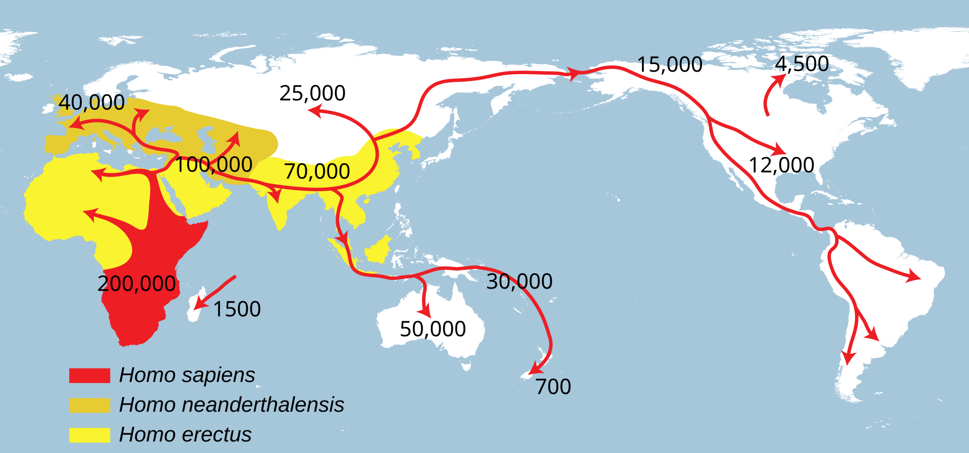
The Southern Coastal Route Out of Africa into Asia
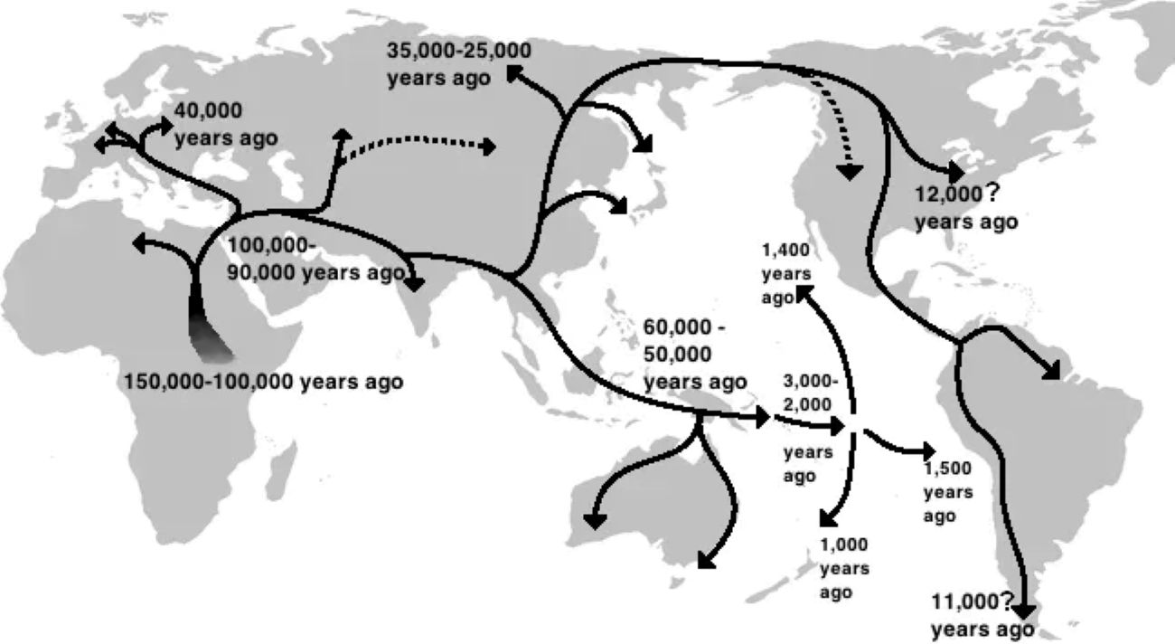
If you were taught that humans left Africa mainly through the Sinai Peninsula and the Levant, the so‑called northern route, that picture is now being rewritten in a big way. Growing genetic and archaeological evidence points to a major early expansion following a southern path out of East Africa, across or around the Red Sea, and then along the coasts of Arabia, India, and onward into Southeast Asia. This “beach‑comber highway” idea was once a niche hypothesis; now it is treated as a central piece in the story of how Homo sapiens spread so fast across the Old World.
Ancient DNA from modern populations in South Asia and coastal Southeast Asia, together with improved dates from sites in Arabia and India, supports the idea that people were hugging shorelines rich in shellfish, fish, and other marine resources as early as roughly sixty to seventy thousand years ago. Climate reconstructions show that during windows of lower sea level, narrow crossings like the Bab el‑Mandeb strait between Africa and Arabia would have been far easier to traverse. When you put that together with the archaeology, the coastal route stops being a romantic speculation and starts looking like a very practical solution for hungry, mobile hunter‑gatherers following food and favorable weather.
The Early Levantine Corridor into Eurasia
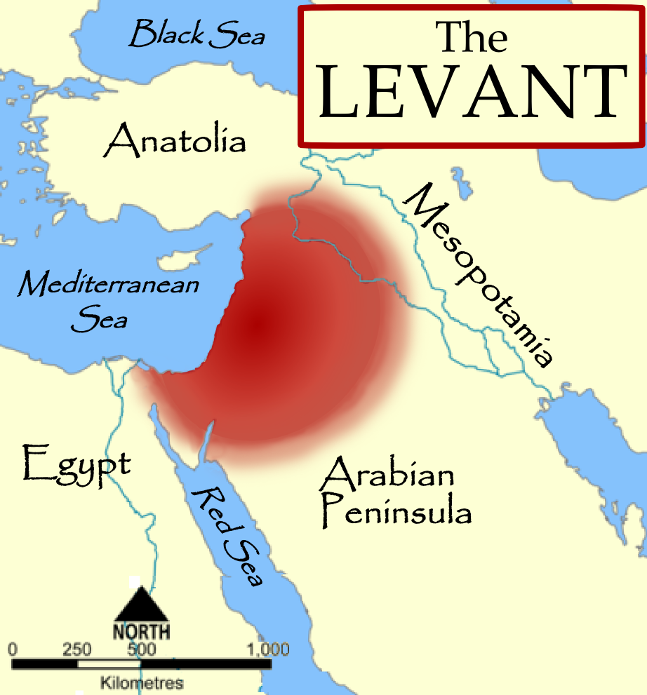
That said, the classic northern corridor through the Levant has not been discarded; it has just become far more nuanced. What used to be drawn as one simple arrow out of Africa into the Near East is now understood as a series of pulses and retreats tied to climate swings, competition with Neanderthals, and shifting landscapes. Fossils from sites in Israel and surrounding regions had hinted at early excursions, but it was hard to tell which of those groups actually contributed to later populations and which were evolutionary false starts.
Recent ancient DNA work, combined with sharper radiocarbon and luminescence dating, has made it clear that some of these early Homo sapiens moving through the Levant tens of thousands of years before the big global expansion were not just one‑off visitors. Some lineages linked to them show up in later Eurasian genomes, suggesting that the Levantine corridor acted like a repeatedly opened doorway, not a single, one‑time exit. I think of it almost like a busy border crossing that opened and closed with the climate: during greener, wetter phases, people pushed north; when conditions deteriorated or competition intensified, populations shrank back or disappeared, leaving only faint traces in the genetic record that we are finally starting to decode.
Crossing into Sahul: The Route to Australia and New Guinea
For a long time, the peopling of Australia and New Guinea – together known as Sahul – was framed as a kind of miracle: somehow, very early humans managed open‑water crossings to reach a continent separated by deep seas. That broad story still stands, but the details have become much clearer and less mystical. With better sea‑level reconstructions and high‑resolution maps of submerged continental shelves, scientists can now sketch at least two likely island‑hopping routes through what is today Indonesia into Sahul, rather than imagining a single heroic leap.
One pathway appears to have threaded through the islands of what is now eastern Indonesia, while another may have skirted more to the north, passing through a chain of stepping‑stone islands when sea levels were much lower. Ancient DNA from Indigenous Australians and Papuans, along with genetic signals in some island Southeast Asian populations, point to an early, rapid movement into Sahul on the order of tens of thousands of years ago, making this one of the oldest successful long‑distance dispersals by our species. Personally, I find this route especially moving: it is hard not to picture small groups scanning distant horizons, timing their crossings with tides and winds, and trusting their lives to knowledge passed down through generations of coastal living.
Through the Green Sahara into North Africa and Beyond
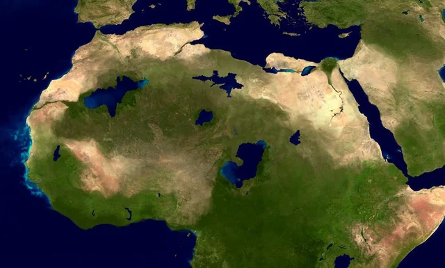
When we think “Sahara,” we picture endless sand and blistering heat, but that image is deeply misleading for much of human prehistory. Several times over the last few hundred thousand years, the Sahara flipped into a giant green savanna dotted with lakes and rivers, a place where hippos, giraffes, and, crucially, human groups thrived. Only in recent years, with satellite imagery, sediment cores, and improved dating of rock art and archaeological sites, have scientists been able to trace how these “Green Sahara” periods created migration corridors through what is now one of the harshest parts of the planet.
These humid phases allowed people to move northward from sub‑Saharan regions into North Africa and then westward or eastward along the Mediterranean fringe. Genetic studies of present‑day North Africans and Sahel populations, as well as ancient remains from North African sites, reveal complicated mixtures of ancestries that make more sense once you accept that the Sahara was periodically more like a vast, passable parkland than an impenetrable desert wall. To me, this flips a common mental map: instead of a sharp boundary between “black Africa” and “North Africa,” we see a dynamic, breathing region that opened and closed, mixing populations in pulses that scientists are just now able to reconstruct with real confidence.
The Pacific Coast Route into the Americas
Perhaps no migration story has been argued over as fiercely as the first peopling of the Americas. For most of the twentieth century, the dominant model imagined small bands walking through an interior ice‑free corridor between massive North American ice sheets. In the last couple of decades, that timeline has fallen apart under the weight of better dates from early sites and the realization that the interior corridor would not have been hospitable early enough. In its place, a coastal migration along the Pacific rim has moved from fringe idea to leading explanation.
What has changed is the convergence of ancient DNA from some of the earliest human remains in the Americas, underwater and shoreline archaeology, and reconstructions of the late Ice Age coastline. A coastal route, with people moving by foot and probably by simple watercraft along a rich marine environment, fits both the genetic branching patterns and the early appearance of humans far to the south in the Americas. The frustrating part is that many of the most important early sites are likely underwater today due to rising post‑glacial sea levels, so researchers are literally hunting along drowned shorelines using sonar and submersibles. Still, the broad outline – a Pacific coastal highway colonized by adaptable maritime foragers – now looks much more like a solid, data‑supported story than the speculative sketch it once was.
The Beringian Standstill and the Inland Spread Across the Americas
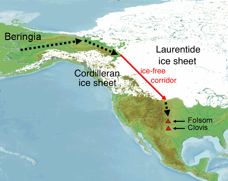
Even if the first Americans reached the continent via a Pacific coastal pathway, that is only half the tale. Another big piece of the puzzle that scientists have only recently teased out is what happened in Beringia – the now‑submerged landmass that once connected Siberia and Alaska – and how people radiated from there into the rest of the Americas. Genetic data from ancient remains in both Siberia and the Americas suggest something like a “Beringian standstill,” a period when ancestral Native American populations lived in relative isolation in that northern region before dispersing southward.
Improved ice‑sheet and climate models, along with new ancient DNA from early North and South American individuals, now allow researchers to track at least two major waves of movement from this ancestral population into the broader continents. Some groups seem to have followed more interior riverine routes as ice retreated, while others retained stronger links to coastal environments. What was once presented as a single, tidy colonization now looks more like a braided river of migrations, splits, and local adaptations. For me, this complexity is the best antidote to oversimplified maps: it reminds us that real people lived through these transitions, making local choices that rippled across entire continents.
Conclusion: Why These Routes Still Matter Today
![Conclusion: Why These Routes Still Matter Today (Skin colour and vitamin D: An updateProvided under Creative Commons free license (p.1, with link to Attribution 4.0 International (CC BY 4.0) page)"This is an open access article under the terms of the Creative Commons Attribution License, which permits use, distribution and reproduction in any medium, provided the original work is properly cited. © 2020 The Authors. Experimental Dermatology published by John Wiley & Sons Ltd" [1], CC BY-SA 4.0)](https://nvmwebsites-budwg5g9avh3epea.z03.azurefd.net/dinoworld/5c0caa84ff9b200276143667595846ed.webp)
When you zoom out, a pattern appears that I think is easy to miss in all the technical detail: humans have always been astonishingly mobile, opportunistic, and curious. These six routes – out of Africa’s coasts and corridors, across drowned shelves to Sahul, through a once‑green Sahara, and along and beyond Pacific shorelines – are not just arrows on an ancient map. They are evidence that our species has repeatedly treated shifting climates and changing landscapes not only as threats, but also as invitations to explore. In an age when modern borders feel rigid and politics around migration are often toxic, the deep history tells a very different story about what it means to be human.
My own view is that the more precisely we map these ancient journeys, the less sense simplistic ideas about “pure” populations or fixed homelands make. Everyone alive today is the product of people who moved, mixed, adapted, and tried their luck in new places when old ones changed. That is not a weakness in our story; it is the source of our resilience. So the next time you see a world map, maybe it is worth imagining those invisible, overlapping trails of past migrations underneath it – because in a very real sense, every line eventually leads to us. Does knowing that change how you see where you belong?