There is something almost electrifying about realizing that the land you walk on has been quietly shaping human beings for tens of thousands of years. Long before cities, smartphones, or written language, the earth itself was the teacher. Deserts, rainforests, river valleys, canyon walls, and frozen tundra didn’t just give people a place to live. They told them who to be.
Every ritual, every building style, every food tradition, every spiritual belief held by these ancient peoples was, in some profound way, an answer to the landscape that surrounded them. Honestly, it’s one of the most humbling ideas in all of human history. So let’s dive into eight extraordinary ancient tribes whose entire cultures were sculpted, tested, and transformed by the prehistoric landscapes they called home.
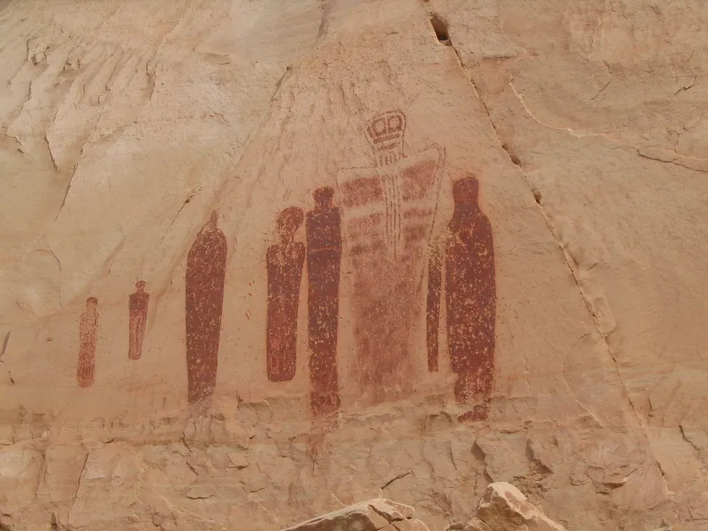
1. The Ancestral Puebloans: Children of the Canyon and the Colorado Plateau
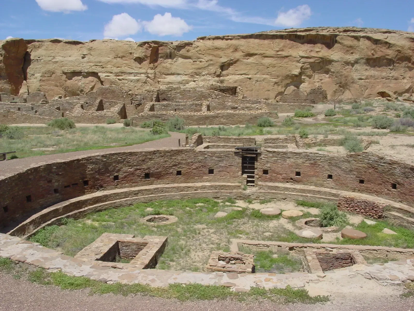
You can’t talk about landscape-shaped cultures without starting here. The Ancestral Pueblo homeland centers on the Colorado Plateau, but extends from central New Mexico on the east to southern Nevada on the west. This is high, rugged, arid country where water is precious and the geology is dramatic. The landscape didn’t just inspire these people. It practically wrote their architectural rulebook.
Archaeologists call the most common forms of their ceremonial structures great houses and great kivas, round semi-subterranean structures used as spaces for religious purposes or large gatherings. The largest and most elaborate of these structures are located in Chaco Canyon, New Mexico, which was an influential center between about A.D. 900 and 1150. Think about that for a moment. A canyon so commanding, so prehistoric in its grandeur, that it became the spiritual capital of an entire civilization. The rock walls didn’t just shelter people. They were woven directly into belief systems.
2. The Hohokam: Masters of the Desert River Basin
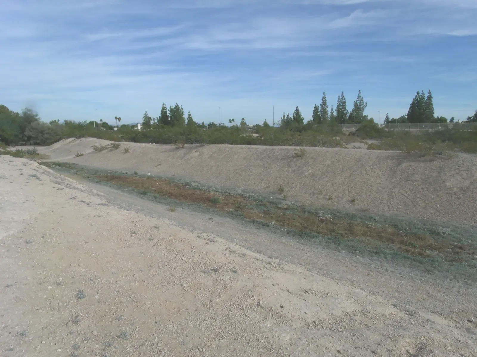
Here’s the thing about deserts. Most people think they are death zones. But the Hohokam looked at the scorching semi-arid landscape of what is now southern Arizona and saw something else entirely. The word Hohokam is a Piman language term for “all used up” or “exhausted,” and the name given by archaeologists to the ancient farming peoples of the southern deserts of Arizona. The Hohokam lived in the Phoenix Basin along the Gila and Salt Rivers, in southern Arizona along the Santa Cruz and San Pedro Rivers. Their survival blueprint was the river itself.
Although floodwater irrigation may have been practiced earlier, it was during their Pioneer Period that the first irrigation canal was built, a 3-mile channel in the Gila River valley that directed river water to the fields. The Hohokam’s development of complex canal networks in the following millennium was unsurpassed in pre-Columbian North America, and this agricultural engineering was one of their greatest achievements. You have to give them serious credit. Hohokam farmers truly had mastered the desert, in the sense that they were able to successfully grow crops in the same locations for hundreds of years and create a large, well-organized, prospering society.
3. The Kuku Yalanji: Rainforest People of Far North Queensland
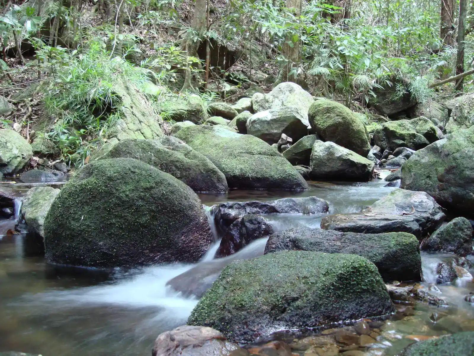
Imagine a landscape so ancient, so biologically dense, that it predates almost everything you know. That is the world the Kuku Yalanji of Australia call home. The Kuku Yalanji people are the Indigenous inhabitants of the land and have a history dating back 50,000 years to the earliest human occupation of Australia. They are true rainforest people, living in complete harmony with their environment. Half a century of millennia. Let that sink in.
Central to Kuku Yalanji spirituality are Dreamtime stories, a complex and symbolic narrative of the creation of the world and all its features. These stories are passed down through generations and serve as a guide to understanding the land, its resources, and the spiritual significance of various sites within the rainforest. Each plant, animal, and geographical feature has a story, and these narratives connect the past, present, and future in a seamless stream. For the Eastern Kuku Yalanji people, many natural features of the landscape have spiritual significance, including Wundu (Thornton Peak), Manjal Dimbi (Mount Demi), Wurrmbu (The Bluff) and Kulki (Cape Tribulation). The rainforest isn’t just scenery to them. It is a living sacred text.
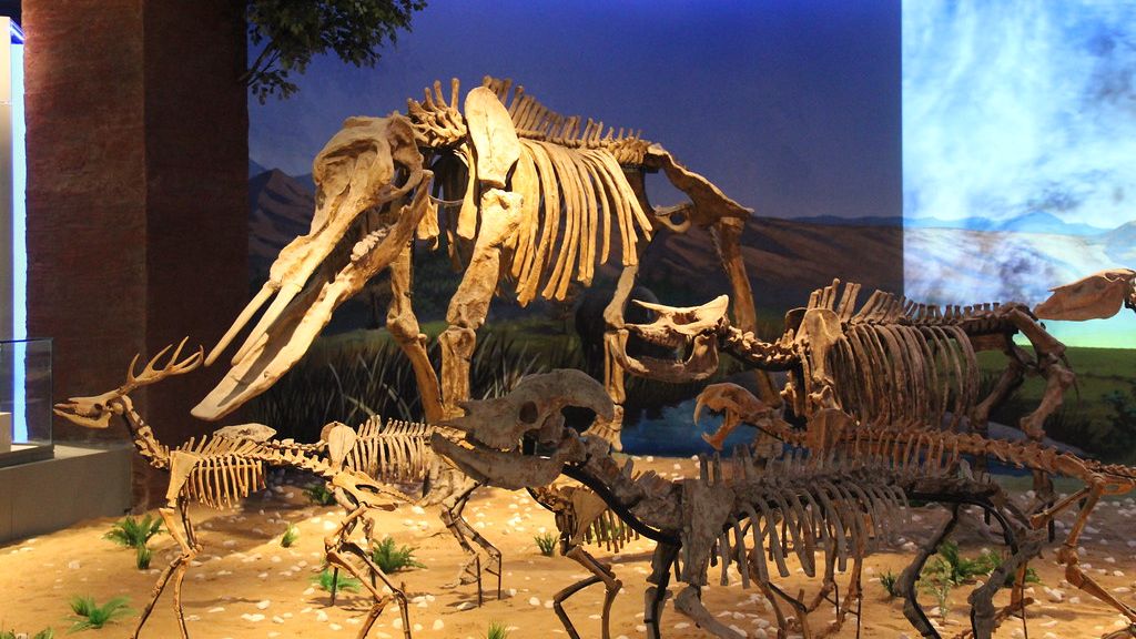
4. The Paleo-Indians: Hunters of a Pleistocene World
Go back far enough and you find the original landscape-shaped people of North America. These were not simple cave dwellers, not by a long stretch. All the Paleo-Indian groups lived in a relatively dynamic landscape that they shared with Pleistocene flora and fauna, most notably with megafauna such as mammoths, mastodons, giant bison, giant ground sloths, sabre-toothed cats, and short-faced bears. Their landscape was, almost incomprehensibly, more dangerous and more spectacular than anything we could picture today.
Clovis projectile points are thin, lanceolate or leaf-shaped, and made of stone. One or more longitudinal flakes, or flutes, were removed from the base of each point’s two flat faces. Clovis points were affixed to spear handles and are often found on mammoth kill sites, usually accompanied by side scrapers used to flense the hide. The terrain shaped not just their diet but their tools, their movement patterns, and ultimately their social structures. You live in a world of mammoths, you build culture around the hunt. It’s that direct.
5. The Archaic Peoples of North America: Settlers Between the Ice and the Farm
Often overlooked in favor of flashier civilizations, the Archaic peoples occupy a fascinating middle ground in human prehistory. By about 6000 BCE some groups had begun to experiment with food production as well as foraging and became known as Archaic cultures. Archaic peoples often returned to the same location on a seasonal basis, and as a result began to build small settlements. The landscape was shifting after the Ice Age, and so were they.
What’s remarkable is how efficiently they read that changing world. Archaic subsistence techniques were very efficient, and in a number of culture areas people sustained an essentially Archaic way of life until after European colonization. Artworks created during the Mesolithic period reflect the arrival of new living conditions and hunting practices caused by the disappearance of the great herds of animals from Spain and France at the end of the Ice Age. Forests now cloaked the landscape, necessitating more careful and cooperative hunting arrangements. When the world around you transforms, your culture transforms with it.
6. The Badari and Naqada Peoples: Forged by the Nile Valley
The Nile River did something extraordinary. It created a narrow green corridor through one of the most hostile desert environments on Earth, and ancient tribal peoples looked at that wet slash through endless sand and built everything. By about 5500 BC, small tribes living in the Nile valley had developed into a series of inter-related cultures as far south as Sudan, demonstrating firm control of agriculture and animal husbandry, and identifiable by their pottery and personal items such as combs, bracelets, and beads.
The largest of these early cultures in northern Upper Egypt was the Badari, which probably originated in the Western Desert. It was known for its high quality ceramics, stone tools, and use of copper. The Badari culture was followed by the Naqada culture, which brought a number of technological improvements. As early as the first Naqada Period, Egyptians imported obsidian from Ethiopia, used to shape blades and other objects from flakes. The river made trade possible. Trade made civilization possible. And it all began with a prehistoric landscape that forced people together along a single lifeline.
7. The Ancestral Mississippian Mound Builders: Sculpted by the River Heartland
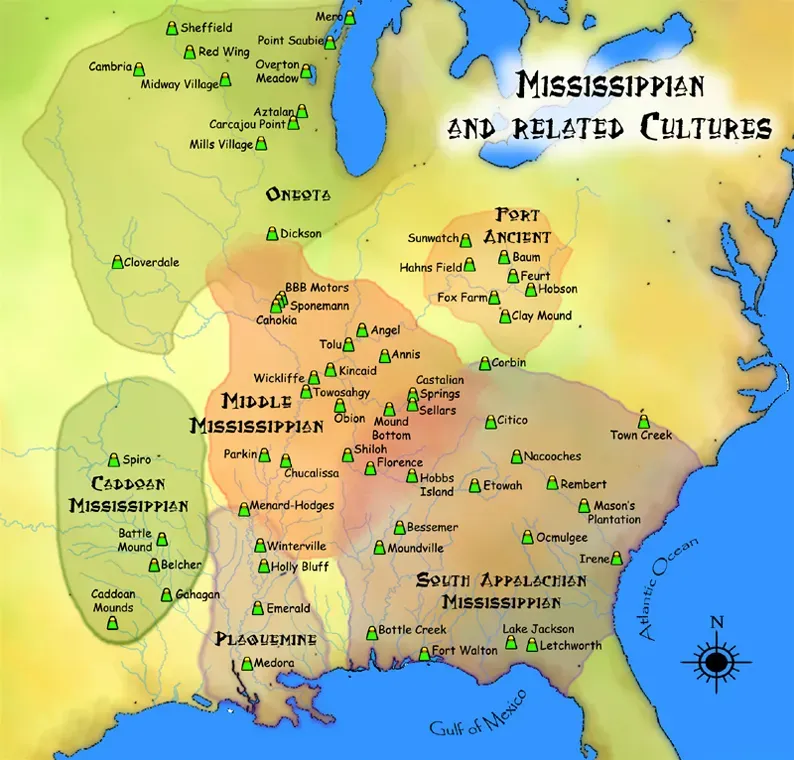
There is a massive earthen mound sitting across from present-day St. Louis that should stop you in your tracks. Across from present-day St. Louis stands an earthen mound 100 feet high and covering 15 acres, bigger at its base than the Great Pyramid of Egypt. This mysterious mound is one of literally thousands that early Native Americans built in the Mississippi and Ohio River Valleys, the Great Lakes region, and along the Gulf Coast. The fertile, flood-rich heartland of North America produced one of prehistory’s most underrated monument-building cultures.
The final period of prehistoric life in the Americas, the Mississippian, occurred between 800 and 1650 AD. Throughout these years Native Americans continued to hunt and fish, but they came to mostly rely on agriculture for food. During this era, Native Americans cleared land by girdling, cutting away a ring of bark from trees to stop growth, or setting fire to a group of trees and used stone tools to assist in the planting of crops in the fertilized ash. The widespread adoption of agriculture, prompted in great part by the domestication of corn, resulted in the extensive clearing of forests and also led to the establishment of permanent villages. The Mississippi River basin didn’t just feed them. It gave them the ambition to build on a monumental scale.
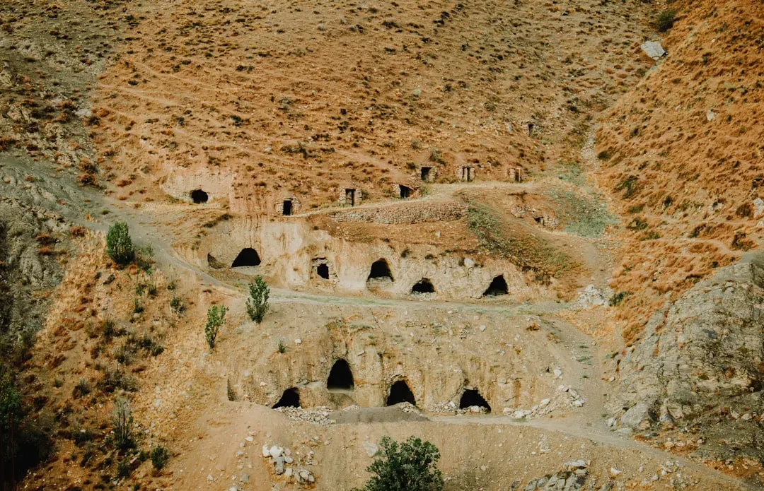
8. The Mogollon and Sinagua Peoples: Shaped by the Desert Mountains
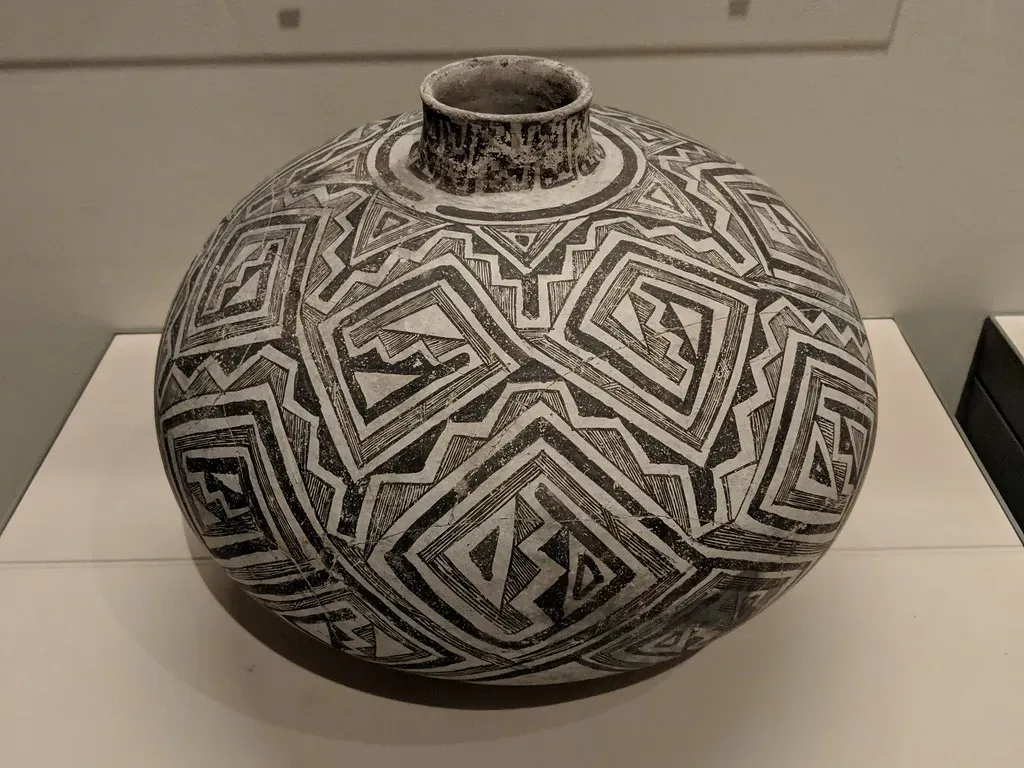
Tucked between the Ancestral Puebloans to the north and the Hohokam to the south, the Mogollon and Sinagua peoples inhabited some of the most geologically complex terrain in prehistoric North America. The Mogollon region includes vast expanses of the Chihuahuan desert of New Mexico and northern Mexico, as well as the Mogollon Mountain range across east-central Arizona. Their culture sits at a crossroads of landscapes, and that position produced something genuinely remarkable.
The Mogollon region in southwestern New Mexico includes the Mimbres culture area, which archaeologists see as a branch or subgroup. The region is famous for the beautiful and expressive black-on-white pottery artisans produced there, depicting animals, people, and narrative scenes, as well as geometric designs. Meanwhile, populations in the Sinagua area lived in large pithouse and pueblo communities. They practiced flexible hunting, gathering, and farming strategies specific to some of the challenging landscapes they inhabited. Two groups, shaped by the same rugged mountain-desert interface, developed art and architecture that still astonishes researchers today. I think that’s the real magic here. Harsh landscapes didn’t crush creativity. They concentrated it.
Conclusion: The Land Always Comes First
What unites all eight of these extraordinary cultures is something deceptively simple. The land was never just a backdrop. It was the main character. American Indians understood and valued the relationship between local environments and cultural traditions, and recognized that human beings are part of the environment. A tribal cultural landscape is any place in which a relationship, past or present, exists between a spatial area, resource, and an associated group of indigenous people whose cultural practices, beliefs, or identity connects them to that place.
Every canyon carved a ceremony. Every river system inspired an engineering marvel. Every forest grew a spiritual cosmology. Recent studies indicate that Indigenous peoples used land sustainably, without causing substantial losses of biodiversity, for thousands of years. These were not primitive people stumbling through a dangerous world. They were sophisticated, adaptive, and deeply intelligent cultures shaped by the most powerful teacher that has ever existed, the earth itself.
The next time you stand at the edge of a canyon, beside a great river, or inside an ancient forest, consider this: somewhere deep in that landscape, a culture was once born from it. What do you think that says about us, and the landscapes we live in today?