
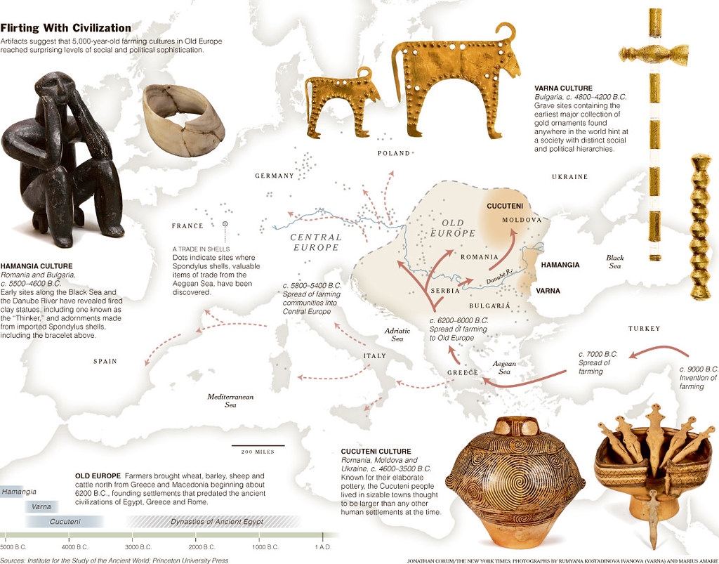
Not that long ago, our picture of early human journeys looked like a handful of thick arrows on a classroom map: out of Africa, into Eurasia, then somehow to the rest of the world. Neat, simple… and wildly incomplete. Over the last decade or so, new tools like ancient DNA, high‑precision radiocarbon dating, and satellite mapping have blown that simple sketch wide open, revealing a maze of forgotten highways our ancestors used to cross deserts, oceans, and frozen landscapes.
What is surprising is not just how far people traveled, but how specific we can now be about the routes they took. We can sometimes trace ancient footprints to particular river valleys, coastal shelves now underwater, or narrow mountain passes that once acted like migration funnels. These six routes are especially fascinating because scientists have argued about them for years, and only recently have they been able to map them with real confidence. Some of the details are still debated, of course, but the broad paths are now much clearer than ever before.
The Southern Dispersal Out of Africa Along the Arabian Coast
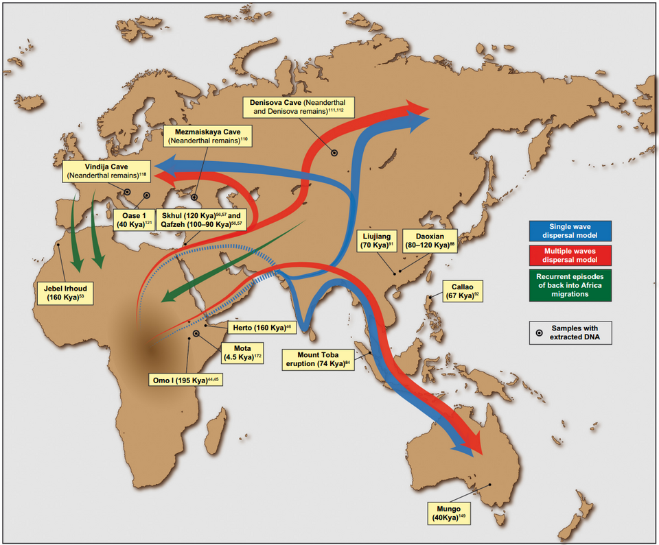
For a long time, the classic story was that early modern humans left Africa through the Sinai into the Levant, then slowly spread into Eurasia. That path is real, but genetic and archaeological work has made it increasingly clear that another major route hugged the southern edge of the Arabian Peninsula. When sea levels were lower during the late Pleistocene, the Bab el‑Mandeb strait between East Africa and Arabia was narrower and likely more passable, turning that region into a critical stepping stone rather than an impassable moat.
What has changed recently is not just the idea of a southern route, but the level of detail in how it is reconstructed. Climate modeling and satellite analysis of ancient river systems in what is now Saudi Arabia show a network of once‑green corridors that would have offered water, game, and shelter to migrating groups. Fossil and stone tool finds, along with genetic patterns in present‑day and ancient genomes, now line up to show a plausible chain: from East Africa across the Red Sea region, along the coasts of Yemen and Oman, and then eastward toward Iran and South Asia. It turns what used to sound like a speculative detour into one of the main highways of early human expansion.
The Early Coastal Pathway Into Southeast Asia and Australia
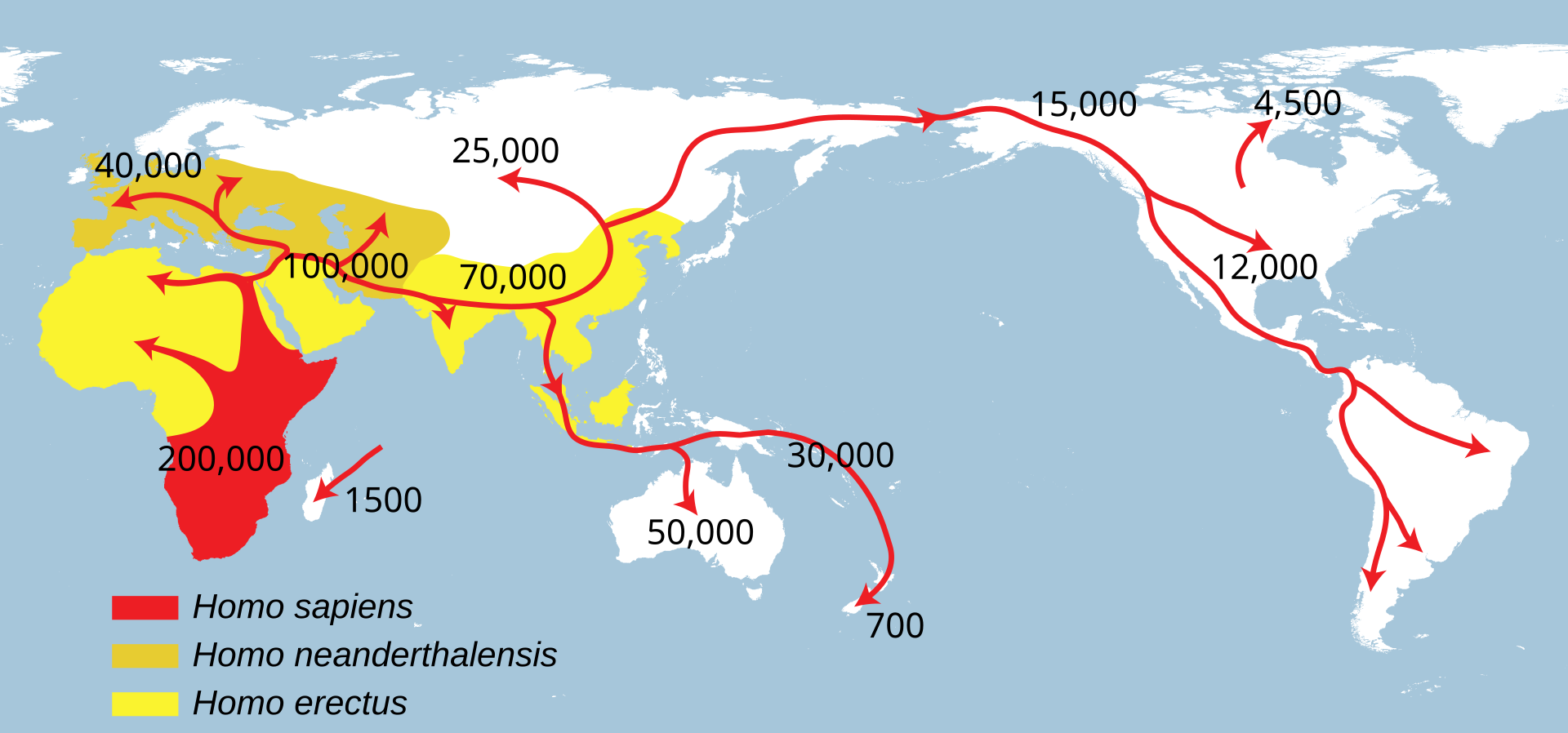
If you look at a modern map, the leap from mainland Asia to Australia feels enormous, but in the Ice Age it was a patchwork of connected lands and short sea crossings. For years, the question was whether people filtered slowly through inland Southeast Asia or raced along the coast, using beaches, estuaries, and reefs like a continuous buffet line. Recent modeling of sea levels, combined with new archaeological finds, has swung the balance strongly in favor of a largely coastal route, even if inland detours certainly happened.
By reconstructing what shorelines looked like tens of thousands of years ago, researchers can identify likely land bridges and island chains that would have been visible from one another. When they then find early sites and ancient DNA on those key stepping stones, the path starts to snap into focus: down the eastern Indian coastline, through the now‑submerged landscapes of Sundaland, across island Southeast Asia, and into Sahul, the landmass that combined ancient Australia, New Guinea, and Tasmania. Personally, I find it mind‑bending that people with stone tools and simple watercraft were making open‑water crossings that many of us today would think twice about attempting in a modern boat.
The Interior Corridor Through the Zagros and Iranian Plateau Into Central Asia
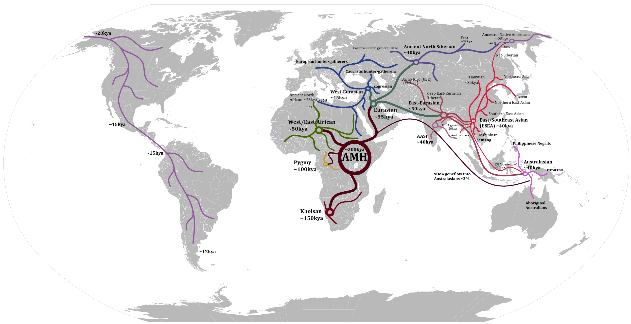
Maps often show migration as coastal arcs, but one of the big shifts in recent research is appreciating how much early humans used interior highlands rather than just skirting the edges. The Zagros Mountains and the Iranian Plateau, once imagined as barriers, have started to look much more like a rugged inland corridor. High‑resolution climate reconstructions suggest that in certain windows of time, these upland regions held pockets of relatively mild, wet conditions compared to harsher lowland basins and deserts.
Ancient DNA from early herders and foragers in Iran, Central Asia, and surrounding regions has revealed distinct but related populations moving through these landscapes and mixing with groups from both the west and the east. When you plot these genetic links against dated archaeological sites in caves and upland valleys, a corridor emerges that stretches from the Near East, through the Zagros and Iranian Plateau, and into the steppe zones of Central Asia. It challenges the comfortable assumption that people always took the easiest path; in many cases, the safer route was the one with water, wood, and game, even if it meant climbing through mountains rather than hugging a flat but barren plain.
The Pacific Northwest Coastal Route Into the Americas
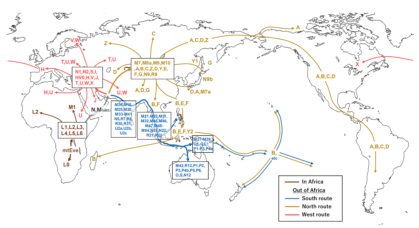
Growing up, I remember seeing the same picture over and over: humans walked into the Americas across a land bridge from Siberia to Alaska, then funneled south through an ice‑free corridor in the heart of North America. That land bridge, Beringia, was real. But the idea of a single interior corridor as the main gateway has been heavily revised. More and more evidence points to an earlier, coastal route along the Pacific Northwest, where people moved by land and sea down an ice‑dotted shoreline that looked very different from today’s rugged coast.
What has really tightened this picture is a combination of glacial science, underwater mapping, and archaeology. Dating of when the interior corridor between the massive ice sheets actually became biologically viable suggests it opened too late to explain the earliest sites in the Americas. Meanwhile, coastal refugia – small pockets of ice‑free land and rich marine ecosystems – have been identified along the now‑submerged continental shelf. A few key early sites in coastal Alaska and British Columbia, along with genetic lineages that match a bottleneck consistent with a small, seafaring founding population, make the coastal pathway look less like a fringe idea and more like the main story.
The Early Trans‑Saharan Networks Linking North and Sub‑Saharan Africa
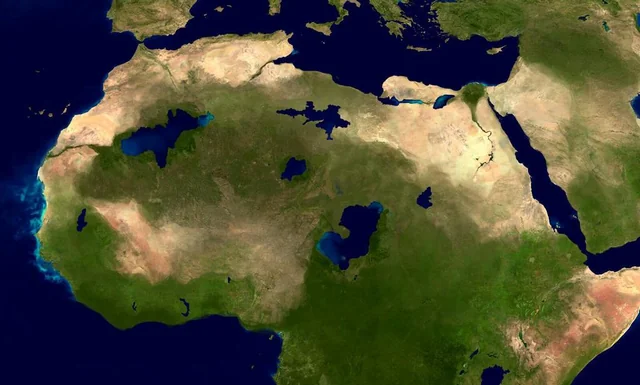
We tend to imagine the Sahara as an eternal barrier, a vast sandy wall between North Africa and the regions to its south. In reality, the Sahara has swung between desert and green savanna again and again, like a giant ecological pendulum. During wetter phases, often called “Green Sahara” periods, this region sprouted lakes, rivers, and grasslands, and the latest archaeological and genetic work has started to map how people used these greener windows to move and mix long before the famous caravan routes of recorded history.
By combining satellite imagery that reveals buried river channels with dates from rock art, lakeside settlements, and skeletal remains, researchers have traced possible north–south corridors that run through central Sahara basins and along paleo‑rivers toward the Nile and the Sahel. Ancient DNA from human remains in North Africa and the Sahara has also shown genetic ancestries that bridge what are today very distinct populations. To me, this is one of the most quietly radical shifts: what we think of as a hard dividing line on modern maps was, in some periods, a giant, lush crossroads where people, languages, and technologies could flow in both directions.
The Eurasian Steppe Highway From Eastern Europe to East Asia
The open grasslands stretching from Eastern Europe all the way to Mongolia and northern China have long been nicknamed the “steppe highway,” but only in the past decade has ancient DNA really illuminated how heavily used that highway was. Early on, researchers suspected some movement of ideas and goods, but the scale and complexity of actual population movements were underestimated. Now, with hundreds of genomes from ancient burials across the steppe, a remarkably connected corridor has taken shape, with people, animals, and genes flowing back and forth over thousands of kilometers.
These genetic signals line up with archaeological evidence of shared technologies, burial customs, and even early horse domestication and wheeled vehicles. Instead of a one‑way spread of “civilization” from one center to another, the steppe looks like an active, two‑way exchange system that repeatedly reshaped populations in both Europe and Asia. I think this overturns a stubborn myth that nomadic or mobile groups are somehow peripheral to history; the steppe route shows that some of the most mobile societies on Earth were also some of the most influential shapers of the human story.
Why These New Maps of Ancient Journeys Matter Today
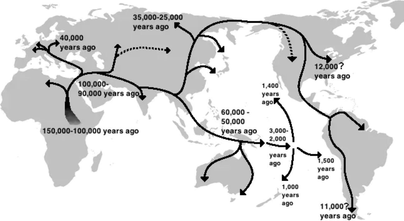
It is tempting to treat these migration routes as dry details from an impossibly distant past, but I think that misses the point. Every time scientists sharpen one of these maps, they chip away at the idea that human groups were ever pure, isolated, or rooted forever in one soil. The DNA shows mixtures upon mixtures; the archaeology shows repeated waves of movement, contact, and reinvention. In other words, mobility is not the exception in human history, it is the rule.
That matters in the present, because questions about who belongs where still fuel politics, identity debates, and sometimes violence. When you realize that your ancestors were probably hitching rides along coastal corridors, mountain passes, and steppe highways just like everyone else’s, it becomes harder to cling to rigid, narrow stories about “us” and “them.” For me, the most honest takeaway is this: humans have always been bridge builders and boundary crossers. The new science is simply catching up to that reality. Knowing that, it is worth asking ourselves whether our modern borders are really as solid and meaningful as we pretend – or whether, deep down, we are still the same restless travelers following the next river, shoreline, or horizon.