You probably grew up hearing about Egypt, Greece, and Rome as the centers of the ancient world. But when you finally stand in front of a weathered stone pyramid in the Americas, with jungle humming all around you or desert wind in your face, it hits you: entire civilizations rose, ruled, and vanished here long before Europeans ever showed up. These places are not side notes to history; they are the main story on this side of the planet.
If you love travel with a bit of mystery, these sites will get under your skin in the best way. You are not just looking at old stones; you are walking through cities where astronomers watched the stars, rulers reshaped landscapes, and whole cultures experimented with architecture, art, and power. Here are ten of the most powerful places to experience that story for yourself.
1. Caral, Peru – Walking Into a City Older Than the Pyramids
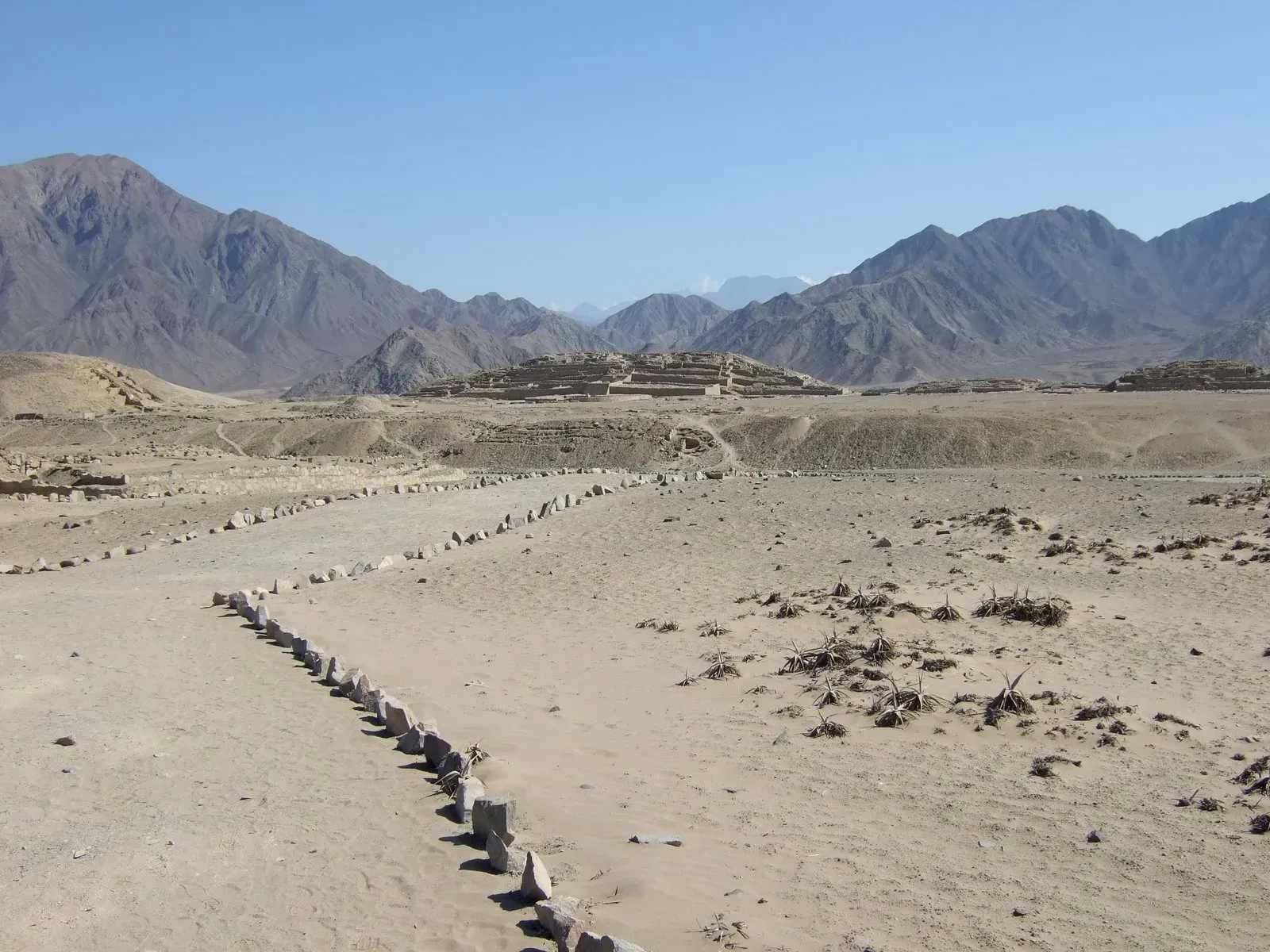
Imagine standing in a city that was already ancient when the pharaohs were just getting started. That is what you walk into at Caral, on Peru’s Supe River, often described as one of the oldest known cities in the Americas, with roots going back nearly five millennia. You wander among low, wide pyramids, sunken circular plazas, and stone platforms that hint at a society organized enough to plan large ceremonial spaces and manage irrigation in a harsh coastal desert.
What really hits you here is the quiet. Caral does not have the crowds of the more famous sites, so you can actually hear the wind move over the ruins and feel the scale of the place without distraction. Archaeologists have found musical instruments, textiles, and sophisticated architecture but surprisingly little evidence of warfare, which challenges the usual assumption that cities always grow out of conflict. When you stand on a platform looking over the Supe Valley, you can almost feel people testing what a complex urban civilization could be, long before “civilization” became a buzzword.
2. Teotihuacan, Mexico – Avenue of the Dead and the City of the Gods
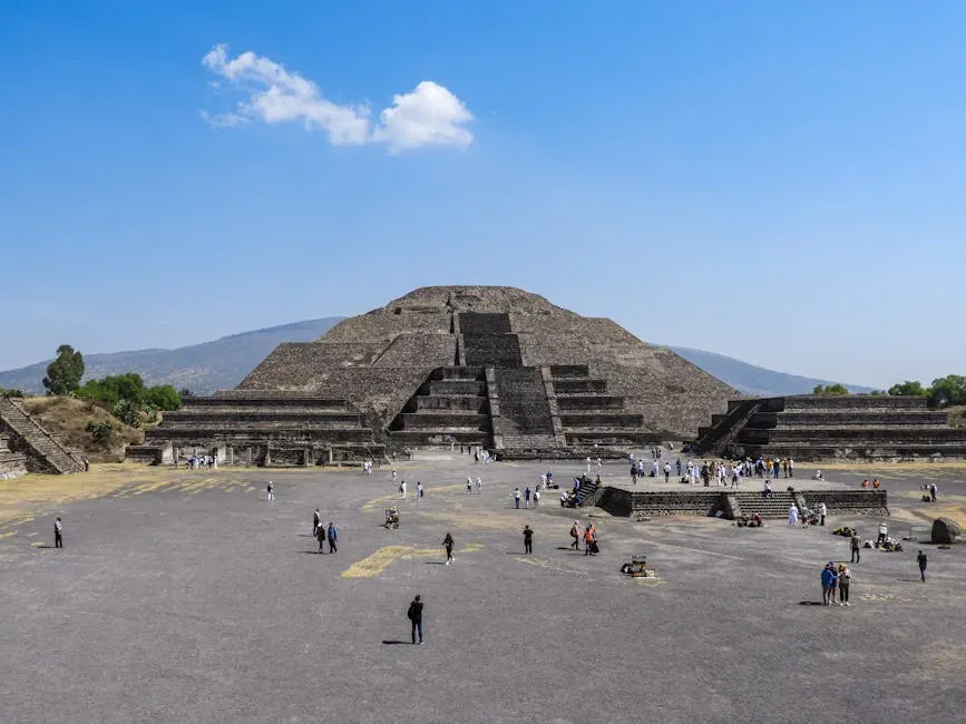
When you first step onto the Avenue of the Dead at Teotihuacan, near modern Mexico City, it feels less like visiting ruins and more like walking into a fossilized metropolis. The scale is absurd: massive pyramids, long avenues, apartment compounds, and plazas laid out with almost geometric precision. At its height, roughly about fifteen centuries ago, Teotihuacan may have been one of the largest cities anywhere in the world, a place where different cultures from across Mesoamerica traded ideas and goods.
Climbing the Pyramid of the Sun or the Pyramid of the Moon, you get that mix of awe and vertigo that makes history feel intensely physical. From the top, the layout starts to look intentional rather than random: archaeologists have found alignments with celestial events and evidence of planned neighborhoods, temples, and markets. You are not just seeing stone; you are seeing urban planning, religious power, and technology, all fused into a city whose original name and language are still unknown. That mystery gives your visit a strange, electric edge – you are walking through a story that is still being decoded.
3. Chichén Itzá, Mexico – Where the Pyramid Talks Back
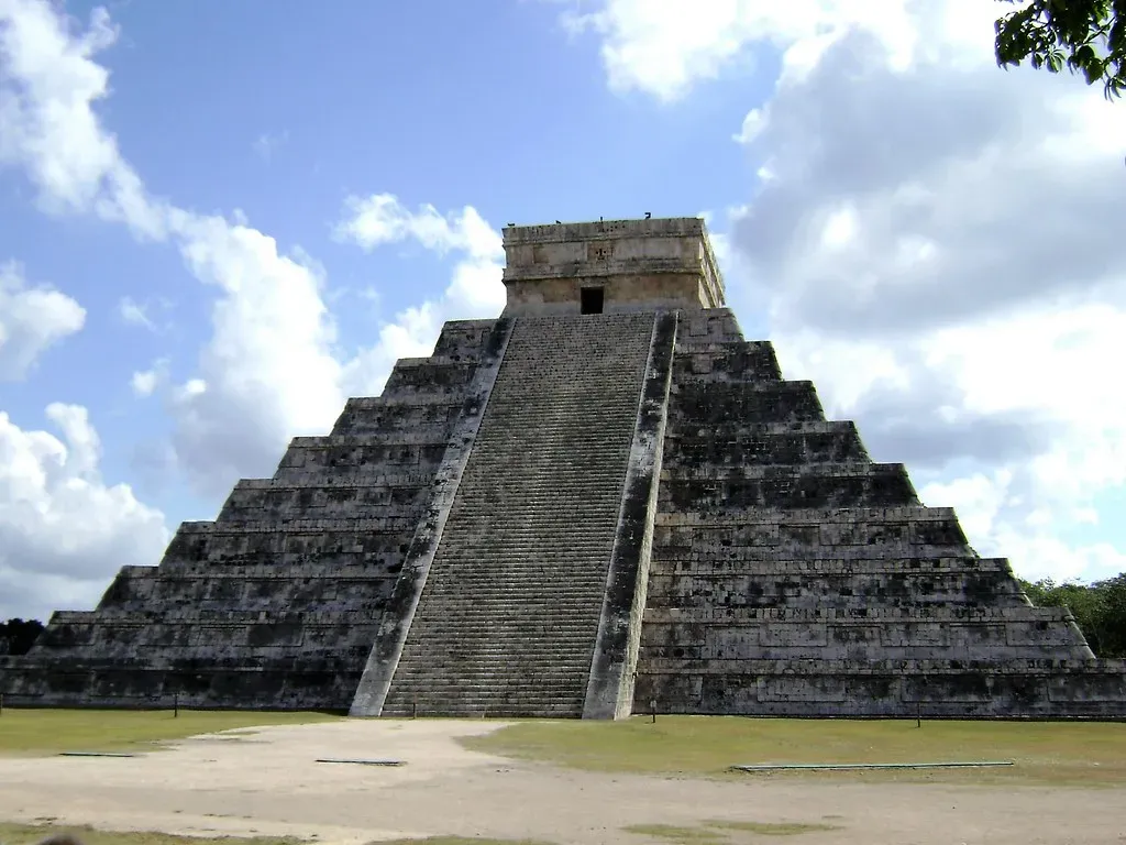
Chichén Itzá on the Yucatán Peninsula is the kind of place that reminds you how precise and playful ancient engineering could be. When you stand in front of El Castillo, the famous step pyramid, you are not only looking at a monument; you are looking at a calendar carved into stone, with stairways and terraces that track solar events like equinoxes. If you clap at the base, the echo that bounces back eerily mimics the call of a sacred bird – an acoustic trick built into the design, not a coincidence.
As you wander the site, you move through observatories, ball courts, temples, and columns that speak to a city that was once a major political and religious hub in the Maya world. The great ball court is so large that you can stand at one end and barely see a person at the other, yet sound carries surprisingly well. Walking these grounds at sunrise, before the tour buses roll in, gives you a chance to feel the place as an ancient visitor might have: a center of power where astronomy, ritual, and politics were woven into every structure you see.
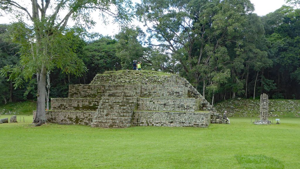
4. Tikal, Guatemala – A Maya City Rising Above the Jungle
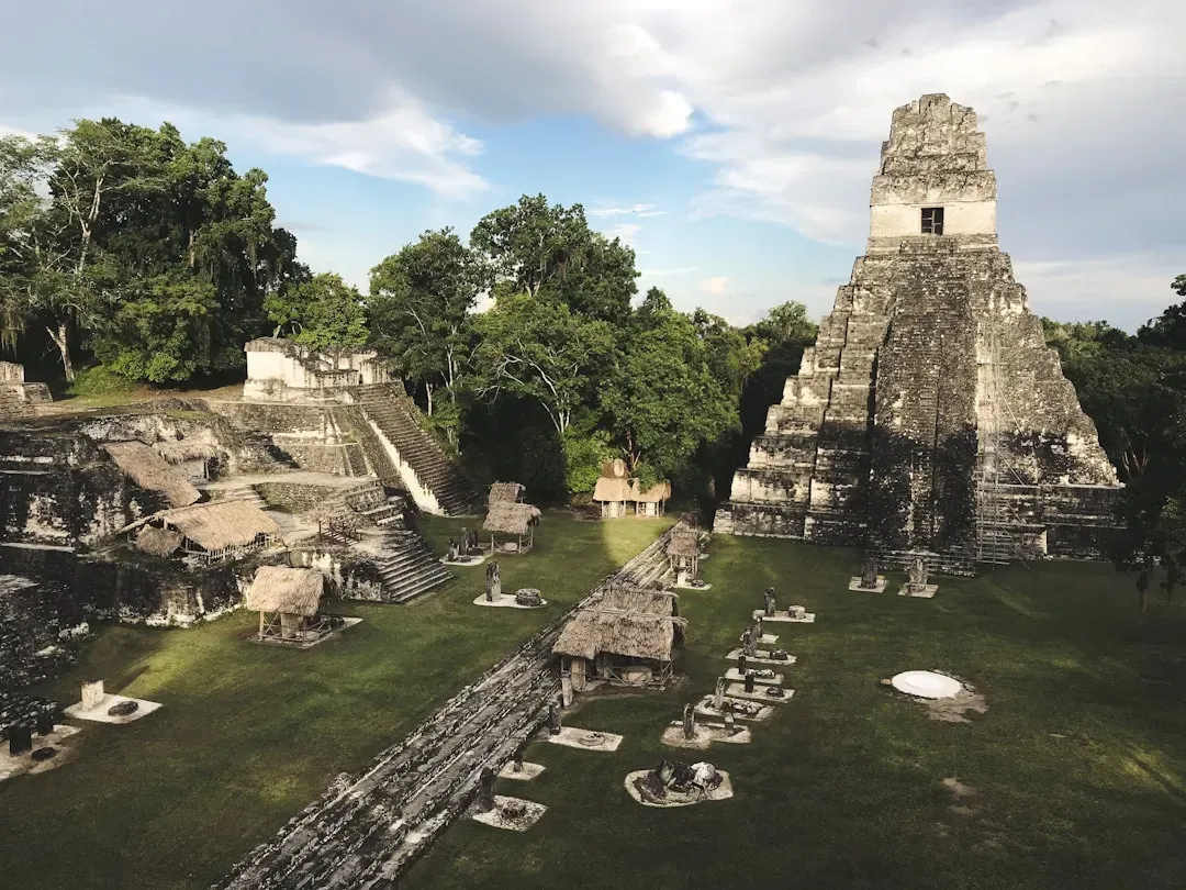
If you have ever wanted to feel like you were exploring a lost city in a movie, Tikal in northern Guatemala will exceed every expectation you have. Temples rise straight out of thick rainforest, their stone crowns pushing through the canopy while howler monkeys roar like distant thunder. At its peak, Tikal was one of the great Maya capitals, powerful in politics, warfare, and trade, linked to other major centers across Mesoamerica.
When you climb up to the top of Temple IV and the jungle opens below you like a green ocean, those stone peaks you see in the distance are other temples, not hills. It makes you realize how vertically imagined this city once was, with rulers literally towering above their people during ceremonies. Walking the causeways between plazas, you pass carved stelae and altars that record royal histories in glyphs you may not be able to read, but you can still sense the drama in them. Tikal gives you that rare feeling of being alone with the past, even if other travelers are just a trail or two away.
5. Machu Picchu, Peru – Not Just a View, but a Whole World in the Clouds
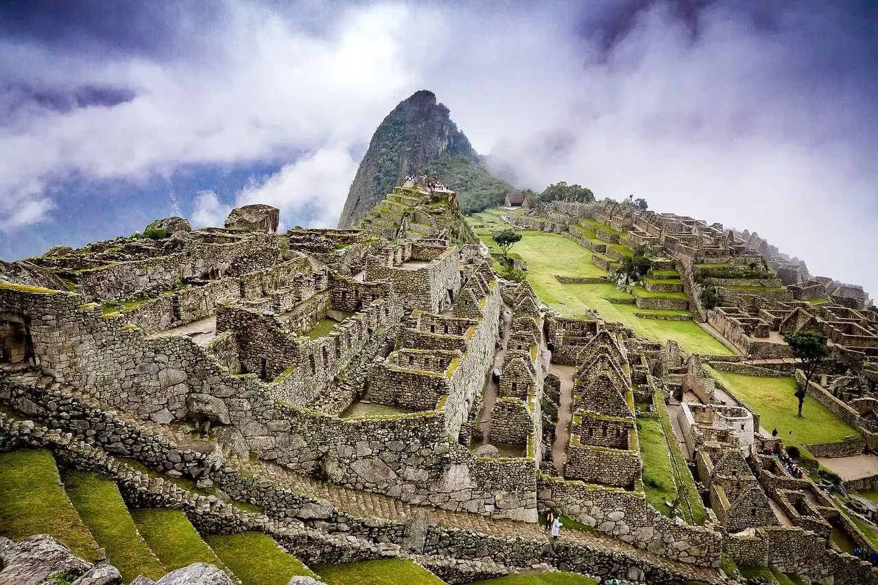
You probably know Machu Picchu from that one iconic photo: green terraces wrapping around a ridge, jagged peaks in the background, clouds drifting like smoke. Seeing it in person, high above the Urubamba River, is still shocking, no matter how many times you have seen it online. This Inca citadel was never truly “lost” to local people, but it sat outside the main Spanish conquest routes, which helped preserve it as an eerily intact window into Inca urban life.
When you walk the narrow stone streets, peek into houses, and trace your hand along the terraces and fountains, you realize how carefully the site is woven into the natural landscape. Agriculture, ritual, water management, and astronomy all intersect here, built with finely cut stones that fit so tightly you sometimes cannot slide a knife blade between them. Whether you hike in along the Inca Trail or arrive by train and bus, the moment you step through the gateway and see the city unfold below you feels like walking into another dimension where mountains and masonry share the same logic.
6. Nazca Lines, Peru – When the Landscape Becomes a Canvas
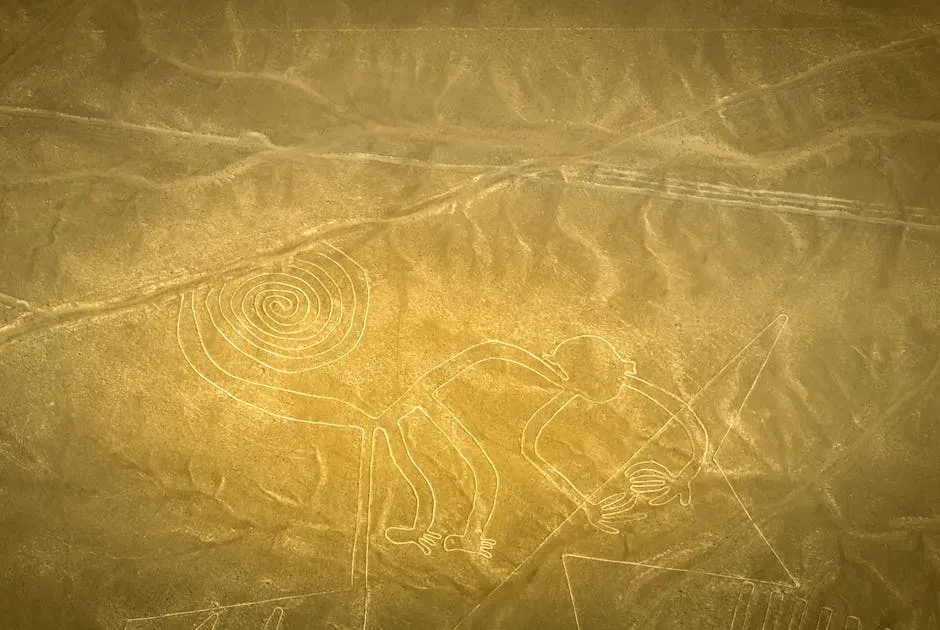
Most ancient sites impress you from the ground. The Nazca Lines flip that idea upside down and demand you look down from the sky. Spread across the desert plains of southern Peru are enormous geoglyphs – lines, trapezoids, spirals, and figures like hummingbirds, monkeys, and spiders – etched into the earth by removing the darker surface rocks to reveal lighter soil beneath. From ground level, many of them look like random paths, but from a small plane they suddenly snap into crisp, stylized images.
No one can tell you with absolute certainty why these geoglyphs were created, and that uncertainty is part of their pull. Some researchers emphasize rituals linked to water and fertility; others focus on astronomical alignments or processional pathways. What you can see clearly is that a society invested serious time and collective effort into turning its landscape into a kind of vast open-air diagram. As you watch the lines slide by under the plane’s wing, you may catch yourself thinking about how your own maps, highways, and satellite images will look to someone thousands of years from now.
7. Tiwanaku, Bolivia – Stones, Stars, and the High Andes
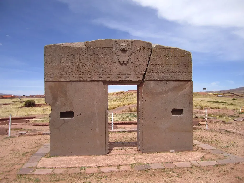
Tiwanaku sits more than two miles above sea level near Lake Titicaca in Bolivia, and you feel every foot of that altitude when you walk its broad plazas. The air is thin and crisp, and the light makes the carved stones look almost unreal, as if they were dropped from another planet. This was once the capital of a powerful Andean culture that predated the Inca, shaping agriculture, beliefs, and trade across a wide region with its temples, pyramids, and monumental gateways.
As you approach the Akapana pyramid or the Kalasasaya complex with its famous “sun gate,” you see the kind of precise stonework that later Andean builders would refine even further. Some blocks are so well cut and fitted that modern visitors still argue about how they were moved and placed with the technology available at the time. With the wide plateau stretching around you and the mountains circling the horizon, you get a sense of a civilization that saw earth and sky as one connected space, not separate realms. It is a humbling, slightly dizzying feeling, both physically and emotionally.
8. Cahokia, United States – A Forgotten North American City of Mounds
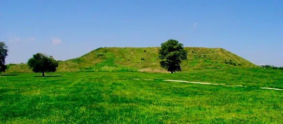
If you grew up in the United States, you might have learned more about European castles than about Cahokia, which is quietly sitting just outside St. Louis on the Illinois side of the Mississippi River. That is a serious blind spot, because at its height around a thousand years ago, Cahokia was a large, complex city of earthen mounds, plazas, wooden palisades, and carefully planned neighborhoods. You are looking at the remains of the largest pre-Columbian city north of Mexico, not just a scattering of isolated mounds.
When you climb Monks Mound, the largest of them all, and look out over the flat river plain, you can imagine a landscape dense with homes, fields, and ceremonial spaces rather than modern highways and suburbs. Archaeologists have uncovered evidence of trade networks, astronomy, craft production, and social hierarchy that rival what you find in more famous Old World sites. Walking the trails today, you see grass, trees, and low, rounded earthworks – but if you let your mind fill in the wooden buildings and crowds of people, the place springs back to life. It is a good reminder that advanced urban societies flourished in North America long before skyscrapers and interstates.
9. Mesa Verde, United States – Cliff Palaces in the Canyons
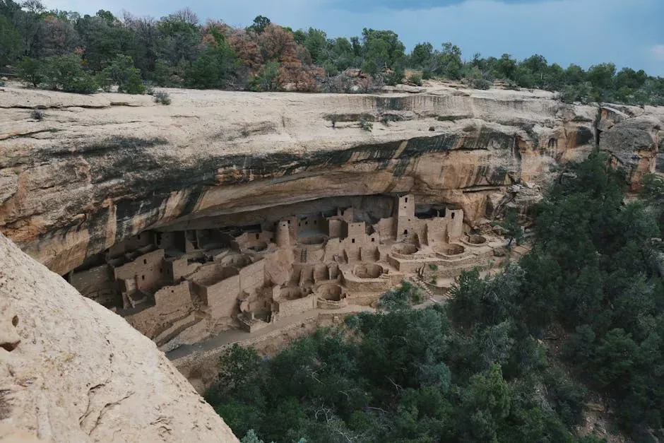
In the canyons of southwestern Colorado, the cliff dwellings of Mesa Verde look almost unreal – their sandstone walls tucked into natural alcoves like swallows’ nests. These were once thriving communities of the Ancestral Pueblo people, with kivas, storerooms, and multi-story homes all packed into sheltered ledges above the canyon floor. Some of the most famous, like Cliff Palace, are so carefully built and visually striking that you might catch yourself wondering why they are not mentioned in the same breath as Europe’s stone castles.
Walking through these dwellings with a ranger or guide, you notice little details that make the place feel intimate rather than abstract: smoke-blackened ceilings, handholds carved into rock, and tiny windows lined up to catch light and air. The people who lived here were experts at farming in a challenging climate, storing food, managing water, and building communities that literally clung to the cliffs. When you step back and see the structures framed by sky and canyon walls, it is hard not to feel a surge of respect for that ingenuity – and a sense of loss that these homes were ultimately abandoned as conditions changed.
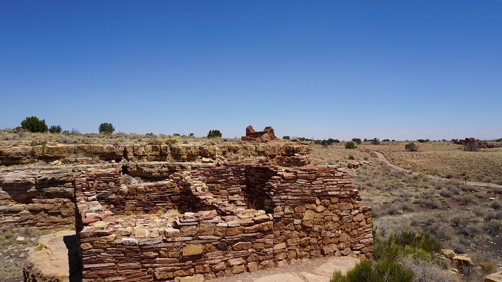
10. Copán, Honduras – Stone Stories on the Edge of the Jungle
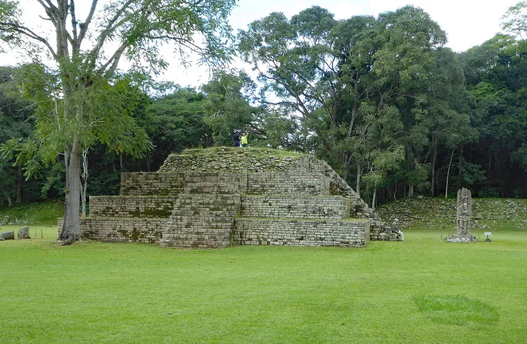
Copán, set in a lush valley in western Honduras, may not grab headlines like some other Maya sites, but if you love detail, it might become your favorite. Here, you are not just looking at big pyramids; you are walking through a world of intricate carvings, altars, stairways, and stelae that read like stone biographies of rulers and gods. The famous Hieroglyphic Stairway packs an extraordinary amount of historical and religious information into a single flight of carved steps, even if you cannot read a single glyph yourself.
As you move from the main plaza into the residential and ceremonial zones, you see how art and architecture blended into everyday and elite life. Sculpted faces peer out from corners; mythic creatures climb up temple walls; and ball courts and plazas tie the spaces together. Copán sat on important trade routes and played a major role in the political chessboard of the Classic Maya world, but standing there today, you mostly feel its human scale. It is one of those places where you can easily imagine conversations, ceremonies, and quiet moments unfolding in the shade – history shrinking down from epic saga to something personal and close.
When you step back and look at all of these sites together, you start to see a very different picture of the Americas than the one many schoolbooks give you. You see cities that rose in deserts, high mountains, jungles, river valleys, and canyon walls; societies that experimented with astronomy, urban planning, art, and agriculture in ways that were just as sophisticated, and sometimes just as strange, as anything happening across the ocean. Visiting even one of these places will probably change the way you think about where “civilization” began and who gets credit for it.
You do not need to see all ten to feel that shift, but each one you visit adds another layer to your understanding, like stacking transparent maps on top of each other until patterns finally appear. So the next time you are planning a big trip and automatically glance toward Europe or the Mediterranean, you might stop and ask yourself a different question: which ancient American city will you walk through first?