If you could step into a time machine and land on Earth during the age of dinosaurs, the first thing that would shock you is not the roar of a Tyrannosaurus or the size of a sauropod. It would be the land itself. The familiar outlines of the modern continents simply would not be there. Instead, you’d find sprawling supercontinents, strange inland seas, and coastlines that seem drawn by a completely different hand.
When you look at a world map today, it feels permanent, almost inevitable. But during the dinosaur era, the surface of the planet was in the middle of a slow-motion rearrangement that completely reshaped where animals lived, how they evolved, and even what the climate felt like. Once you start to picture that shifting puzzle of land and ocean, the age of dinosaurs stops feeling like a static backdrop and starts to look more like a long, epic movie with moving sets.
The World of Pangaea: One Giant Dinosaur Continent
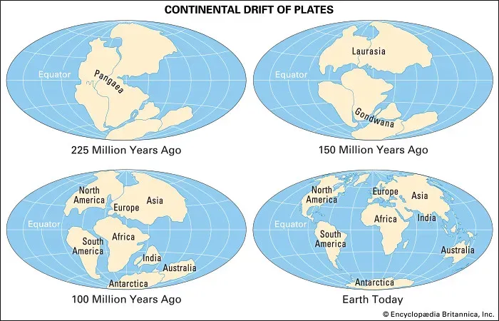
At the dawn of the age of dinosaurs, you would not have needed a passport to travel from what is now New York to North Africa or from Brazil to Western Europe. All of those places were stitched together in a single massive landmass called Pangaea. If you could fly over it, you would see one supercontinent wrapped around the equator, surrounded by a global ocean that covered almost everything else.
On the ground, this meant you could, in theory, walk across thousands of miles of connected land without ever crossing a major sea. That huge, joined-up continent changed how life spread. Early dinosaurs could roam enormous distances, and species were not as boxed in by oceans the way they are today. You can still see the legacy of that ancient connection in the rocks: similar dinosaur fossils and plant remains turning up on continents that are now separated by entire oceans.
Breaking Apart: How Pangaea Slowly Shattered
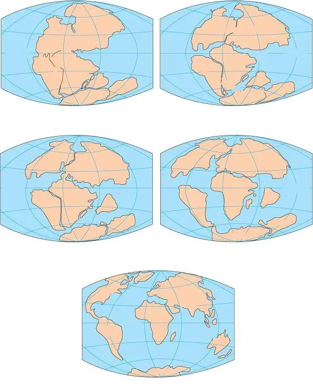
If you stayed on Earth through the whole Mesozoic era, you would not see continents zipping around like pieces on a game board. Instead, you’d sense a painfully slow but relentless drift. Deep under your feet, the planet’s interior heat pushed and stretched the crust, opening cracks that filled with molten rock and, eventually, seawater. Over tens of millions of years, those cracks grew into full-blown oceans, slicing Pangaea into smaller pieces.
At first, the split ran roughly along what would become the Atlantic Ocean, separating the land that would form North America from the blocks that would form Africa and Europe. Later on, other rifts cut into the southern parts of the supercontinent, peeling off what would become South America, Antarctica, India, and Australia. If you could speed this process up like a time-lapse video, you would watch the great single continent stretch, fracture, and drift apart like a slow, grinding ice sheet breaking up on a vast lake.
Jurassic Coastlines: A Warmer, Wetter Planet
By the Jurassic period, when long-necked sauropods and fearsome theropods were striding across the land, you would notice that coasts were creeping in and seas were nibbling further into the continents. As Pangaea split, new shorelines formed, and shallow seas spread over low-lying areas. The climate, on average, was warmer than what you experience today, and there were no polar ice caps to lock away water.
For you, that would mean a world with more humid regions, lush coastal plains, and widespread forests, especially in the middle latitudes. Inland deserts still existed, but the extreme, super-dry interiors of early Pangaea slowly gave way to more varied environments. If you wandered across Jurassic Earth, you’d move through wet fern-filled lowlands, conifer forests, and coastal deltas instead of the sharp contrast between modern arid interiors and ocean-dominated margins.
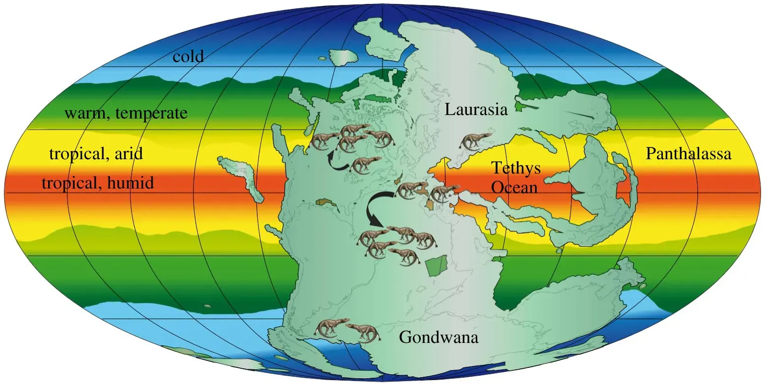
Gondwana and Laurasia: A Split Planet for Dinosaurs
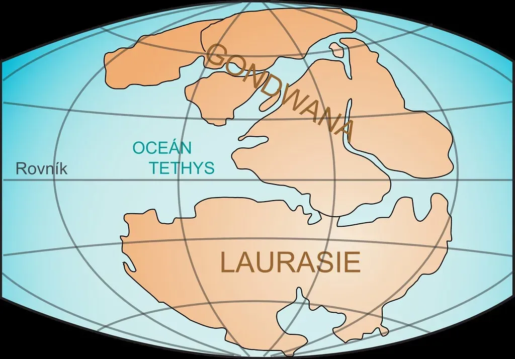
As the breakup continued, the single world of Pangaea turned into two great continental groups that would shape dinosaur evolution: Laurasia in the north and Gondwana in the south. If you looked at a globe at that time, Laurasia would include what you now call North America, Europe, and much of Asia, while Gondwana would hold South America, Africa, Antarctica, India, and Australia. Oceans and widening seaways increasingly separated these blocks.
For dinosaurs, this growing division meant isolation and innovation. Once populations became separated by wide stretches of ocean, they followed their own evolutionary paths. If you could jump from Laurasia to Gondwana during the later dinosaur periods, you would find different mixes of species, like visiting two distant but related branches of the same family. Over time, that geographic separation helped create the regional dinosaur faunas that paleontologists now piece together from fossil sites across the world.
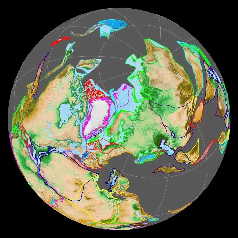
Inland Seas and Strange Interiors: North America’s Lost Ocean
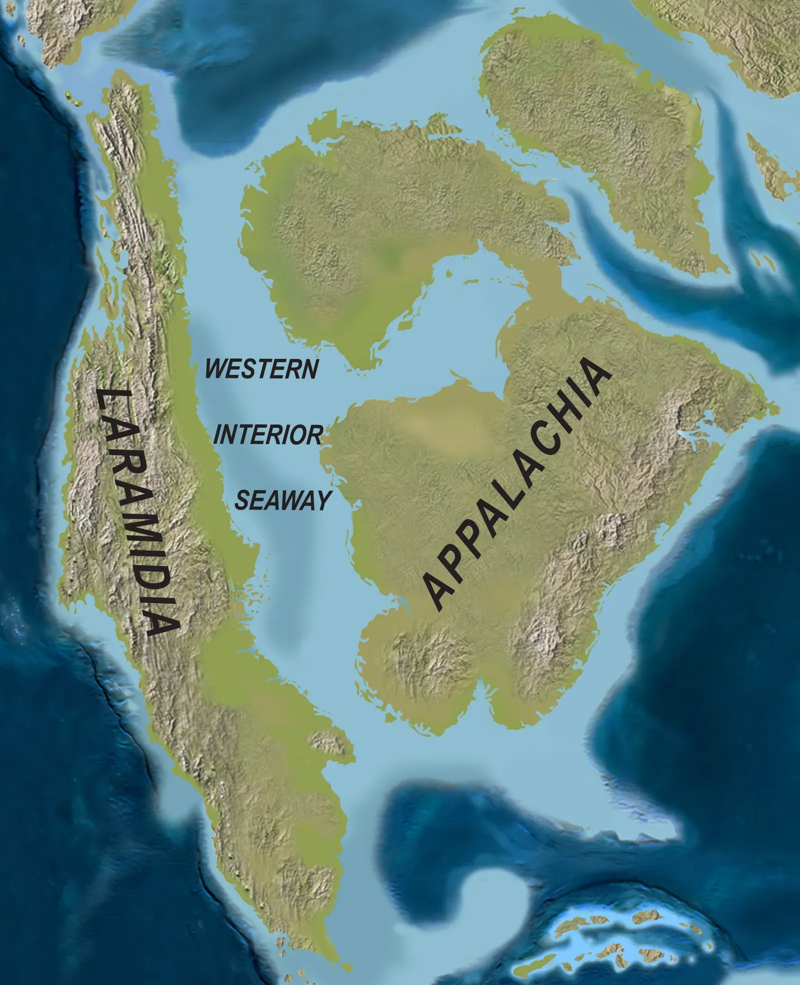
One of the most surprising continental twists comes when you focus on North America during the Late Cretaceous. If you stood in the middle of the continent back then, you might not be on land at all. Instead, you could be floating in a broad, shallow sea that ran from the Arctic down toward what is now the Gulf of Mexico. This inland sea effectively cut North America into two long, narrow landmasses.
On the western side, along a chain of rising mountains, you would find different dinosaur communities than on the eastern side, which had lower, more coastal environments. This watery barrier acted like a selective filter, limiting which animals could cross and splitting populations that once shared the same ranges. When you think of dinosaurs in North America, you often imagine a single huge land full of them, but for a long stretch, the middle of that land was covered by water.
Continental Drift and Dinosaur Diversity

When you track how the continents moved during the dinosaur era, you’re really watching the stage for evolution being constantly rebuilt. Every time a landmass split, collided, or drifted into a new climate zone, it created fresh opportunities and new challenges for the animals living there. You can think of it like a long-running reality show where the rules and the rooms of the house keep changing, forcing the contestants to adapt or vanish.
As continents drifted toward or away from the equator, regions warmed or cooled, sea levels rose and fell, and routes for migration opened or closed. You, standing in one place for a few million years, would slowly see plant communities shift and animal lineups change, even if the land beneath your feet remained the same. The incredible variety of dinosaur species you read about is tightly tied to this slow rearrangement of the continents and the shifting belts of climate that went with it.
From Dinosaur World to Modern Map: What Still Remains
Even though you live in a world that looks completely different from the age of dinosaurs, you can still trace the scars of that ancient geography. Mountain ranges like the Appalachians and parts of the Andes and Himalayas carry the fingerprints of past continental collisions that began or continued in the Mesozoic. The shapes of coastlines around the Atlantic hint at the puzzle-like fit they once had when they were joined as part of Pangaea.
When you study a modern map with this in mind, you’re not just looking at where things are now, you’re seeing a frozen frame in a film that started long before dinosaurs and is still running under your feet. The continents will keep shifting for millions of years to come, just as they did when dinosaurs ruled the land. In a sense, you’re walking on the same moving plates that carried giant sauropods and raptors, just in a later chapter of the same planetary story.
How You Can Actually See This Ancient World Today
You might never get to step into a real time machine, but you can still glimpse the dinosaur-era continents in a surprisingly direct way. When you stand at a museum exhibit and see the same type of dinosaur or ancient reptile found in both South America and Africa, you’re looking at evidence that those lands were once joined. Rock layers that match across oceans tell you that the continents were once stitched together where water now lies.
You can also use digital reconstructions and paleogeographic maps to mentally travel through time. When you compare those maps with modern ones, you start to feel just how temporary the outlines you grew up with really are. The more you look, the more you realize that Earth during the dinosaur era was familiar yet deeply alien: the same planet, the same oceans and sky, but a land layout that would leave you completely lost without a guide.
When you zoom out and think about it, the biggest difference between your world and the world of dinosaurs is not just who was walking on the surface, but how that surface itself was arranged. You live in the aftermath of a colossal, slow-motion tectonic shuffle that turned one supercontinent into the scattered lands you know today. The map you carry in your head is just one moment in a long, unfinished story of drifting plates and changing worlds.
If you could stand at the edge of ancient Pangaea, watch it splinter, and then fast-forward to the modern globe, you’d see that nothing about Earth’s geography is truly permanent. The continents that look so stable under your feet are already on their way to a new configuration that future life will inherit. Knowing that, you might look at your next world map a little differently and wonder: if dinosaurs could see your Earth, would they even recognize it at all?