If you could rewind Earth’s history like a movie, the planet you’d see at the beginning would feel almost alien. No familiar continents, no blue-green globe with recognizable outlines, just a hot, restless world trying to cool down and find its shape. Over billions of years, that chaos slowly turned into the patterned dance of continents drifting, colliding, and breaking apart that you learn about in school.
When you zoom out over deep time, you discover that Earth’s surface is anything but static. What feels solid under your feet is really just the top layer of a planet that never stops moving. By tracing the evolution of continents – from their fiery birth to the modern world – you start to see your home planet as a living, breathing system, not just a rock floating in space.
The Fiery Beginnings: From Molten Planet to First Crust
Imagine standing above a newborn Earth more than four and a half billion years ago: there would be no continents, no oceans, just a glowing sphere of molten rock bombarded by space debris. In those early days, the surface was so hot that any solid crust that tried to form would be quickly recycled back into the interior. Over time, as the planet radiated heat into space and the impacts slowed down, a thin, fragile crust began to harden on top of the cooling mantle, like the first skin forming on a pot of hot soup.
You can think of that first crust as the ancestor of all the continents you know today. It was mostly made of dense, dark basaltic rock, similar to what you see in modern ocean floors. Water from volcanic outgassing and, most likely, icy bodies from space began to accumulate at the surface, helping to cool the crust further. As this early shell thickened, parts of it started to behave differently under pressure and temperature, setting the stage for lighter, more buoyant continental material to appear.
Birth of Buoyant Continents: How Granite Changed Everything
Continents are not just thicker patches of ocean floor; they are made of different stuff. When hot basaltic crust melts partially, the melt that rises can form lighter, silica-rich rocks like granite. Picture pockets of this lighter material slowly floating upward and solidifying, like blobs of cream rising in a pot of darker soup. Over long stretches of time, these buoyant granitic masses gathered and merged, becoming the roots of the first true continental blocks.
Once you have these lighter, thicker patches of rock, they begin to behave like rafts on the denser, underlying mantle. Because they are more buoyant than basaltic crust, they resist being pulled down and destroyed, so they persist and grow. Each collision, each episode of melting, and each bout of volcanism adds more material onto these early continents. By a few billion years ago, you would already recognize big, stubborn chunks of land clinging to the surface while denser rocks beneath them kept moving and recycling.
Supercontinents Before Pangaea: The Forgotten Worlds
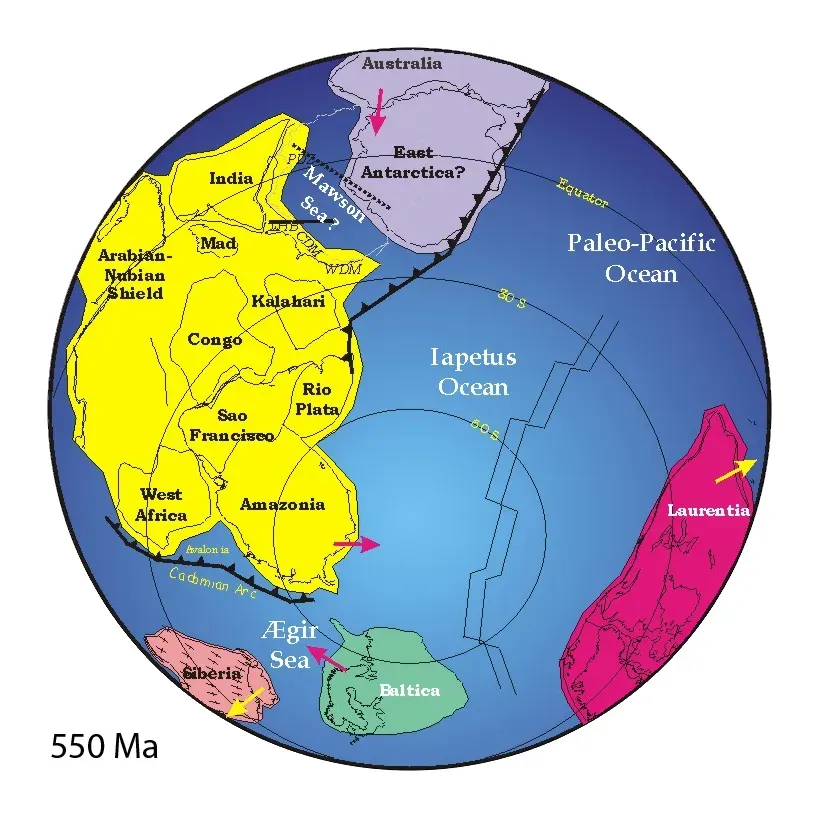
When you hear about ancient continents, you probably jump straight to Pangaea, but Earth’s landmasses had been coming together and breaking apart long before that. Geologists see evidence for a whole series of earlier supercontinents, with names like Nuna (or Columbia), Rodinia, and Pannotia. You can picture them as experimental versions of the global jigsaw puzzle, where most of the available continental pieces clumped together into one oversized landmass surrounded by a global ocean.
You know these supercontinents once existed not because anyone saw them, but because the rocks remember. Matching mountain belts appear on different continents, like torn pages from the same book now shelved on opposite sides of a library. Magnetic minerals in old rocks preserve the direction and strength of Earth’s magnetic field when they formed, letting you reconstruct where those rocks sat on the globe. When you pull all that evidence together, you see that supercontinents are not rare accidents – they are recurring chapters in the planet’s long story.
Pangaea’s Rise and Fall: The Most Famous Supercontinent
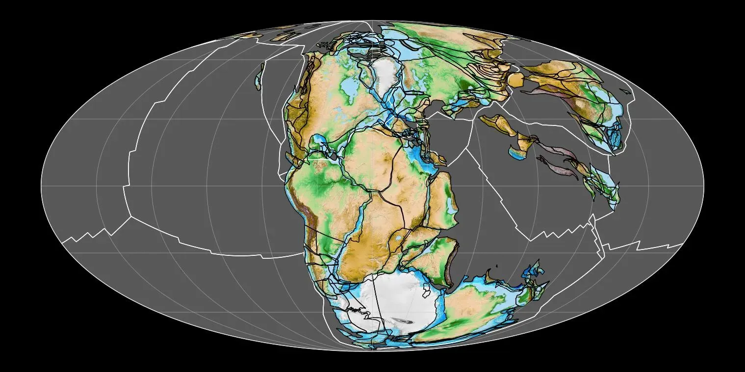
Fast-forward to a time about a few hundred million years ago, and you would see Pangaea stretching almost from pole to pole, a colossal landmass where most of Earth’s continents today were welded together. If you had walked across it, you could have started where North America and Europe now drift apart and ended up in regions that would someday become Africa, South America, or Asia, all without ever crossing an ocean. Its interior would have been vast, dry, and seasonally extreme, far from the moderating influence of the sea.
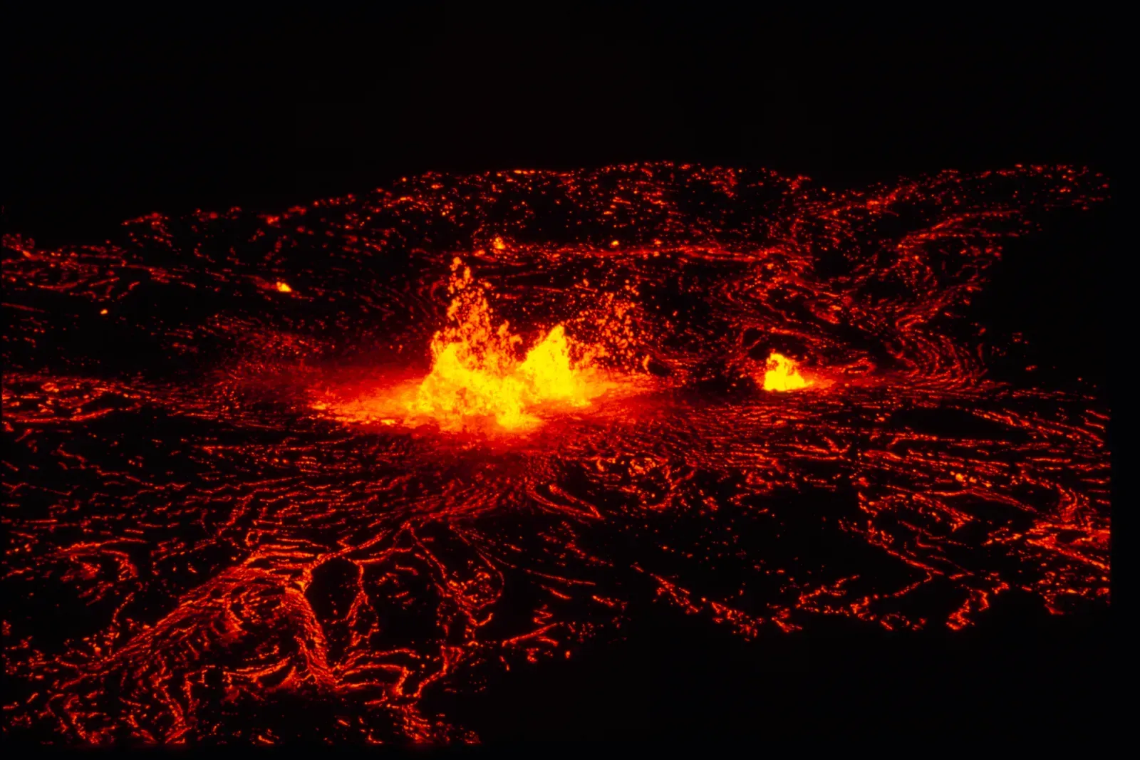
Pangaea did not last. The same forces that built it eventually tore it apart. Heat from within the Earth collected beneath this enormous plate, weakening it and encouraging rifts to open like cracks in drying mud. Over tens of millions of years, those rifts deepened into new ocean basins, and great lava flows paved the way for the Atlantic Ocean. You can still trace this breakup in the way coastlines mirror each other, in matching fossils on now-distant shores, and in ancient mountain belts that abruptly terminate at one continent and pick up again on another.
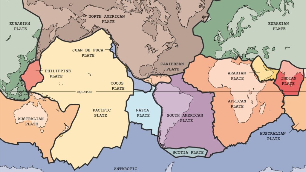
Plate Tectonics: The Engine Behind Continental Drift
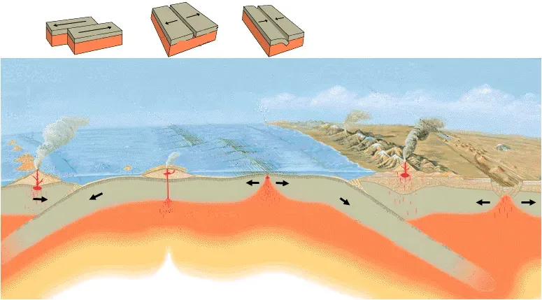
All of these grand rearrangements come down to one big idea you live with every day, even if you never notice it: plate tectonics. Earth’s outer shell is broken into large plates that move slowly over the softer, convecting mantle below. Hot material rises in some places, spreads outward, and cools, while colder, denser slabs sink back down in others. You can imagine a gigantic conveyor belt system beneath your feet, constantly rearranging the puzzle pieces of crust on top.
Continents ride on these plates like passengers, so wherever the plates go, the continents follow. When plates move apart, new ocean crust forms; when they crash together, mountains rise and pieces of crust can be shoved upward or sideways. At some collision zones, dense ocean crust dives beneath lighter continental crust and melts, feeding volcanoes and adding new material to the edges of continents. Over time, this steady churning turns the globe into a restless, shape-shifting world rather than a rigid, frozen one.
Modern Continents on the Move: Today’s Shifts and Tomorrow’s World
It is easy to think that the continents have reached their final positions because maps look so definitive, but if you jump ahead millions of years in your mind, the outlines will not be the same. Measurements from satellites show that places like the Atlantic Ocean are widening by roughly a couple of centimeters per year, while parts of the Pacific are shrinking as plates there dive back into the mantle. India has already slammed into Asia, forming the Himalayas, and that collision is still slowly pushing the mountains higher.
When you stretch these motions over tens of millions of years, they add up to dramatic changes. Some researchers expect that a new supercontinent will eventually form again as current oceans close and continents regroup, though there is debate about exactly where and how it will assemble. You might hear names like “Amasia” or “Aurica” used for potential future supercontinents, each based on different models of plate movement. Whatever the final shape, the lesson is the same: the map of the world you know is just one temporary frame in a never-ending tectonic film.
Continents, Climate, and Life: A Deep Interconnection
The movement of continents has never been just a geological curiosity; it has reshaped climate and life over and over again. When large landmasses cluster near the poles, ice sheets can spread more easily, influencing global temperatures and sea levels. When continents straddle the equator, warm currents and moisture patterns shift, altering rainfall, storm tracks, and the spread of deserts. You can think of continents as giant knobs that slowly tune Earth’s climate by redirecting oceans and atmosphere.
Life responds to these shifts, sometimes gradually and sometimes catastrophically. As continents break apart, isolated populations evolve separately, giving rise to unique ecosystems and new species. When landmasses collide, mountain building alters habitats and creates new niches. In some cases, massive volcanic eruptions linked to continental rearrangements have coincided with major extinction events. The continents underneath you are not just passive platforms for life; they are active players in life’s long, unpredictable story.
Reading the Rocks: How You Reconstruct Lost Worlds
Even though you cannot travel back to see Rodinia or Pangaea with your own eyes, you can still piece together their outlines using clues locked in stone. Rock layers that match in age and type on different continents hint that they were once connected. Mountain ranges with the same internal structure and composition on separate landmasses tell you they were built by the same collision. Tiny crystals inside rocks carry chemical fingerprints of the conditions under which they formed, from temperature and pressure to the depth in the crust.
Magnetic minerals act like microscopic compasses, lining up with Earth’s magnetic field when they cool and preserving that orientation for billions of years. By studying where those compasses point in ancient rocks, you can infer where the rocks once sat on the globe relative to the magnetic poles. Seafloor patterns, like stripes of differing magnetic signatures on either side of mid-ocean ridges, record the spreading of the ocean floor and the past behavior of Earth’s field. When you combine all these strands of evidence, you effectively become a detective of lost continents and forgotten oceans.
Conclusion: Seeing Your Planet as a Work in Progress
![Conclusion: Seeing Your Planet as a Work in Progress ([4], Public domain)](https://nvmwebsites-budwg5g9avh3epea.z03.azurefd.net/dinoworld/2bfea5a195efcea7e1d86149dc76be82.webp)
Once you understand how continents evolve, you stop seeing maps as permanent truths and start seeing them as mere snapshots. The land under your feet has a long, complicated past that includes fiery origins, grand collisions, and long periods of quiet drift. Every mountain, coastline, and inland basin is part of this tectonic diary, written slowly but relentlessly over billions of years. You are living on a moving platform that just happens to be going slow enough for you to call it stable.
When you zoom out over deep time, Earth feels less like a static backdrop and more like a character with its own rhythms and moods. Continents will keep migrating, oceans will keep opening and closing, and future beings – if they are around – will see a very different map than you do today. By recognizing that, you gain a deeper appreciation for how fleeting your familiar world really is. The question is not whether the continents will change again, but which chapter of their ongoing journey you happen to be standing in right now – what do you imagine the map will look like millions of years from today?