Most people picture prehistoric humans as barely-scraping-by survivors – cold, hungry, and focused entirely on not getting eaten. Then you look at an 11,000-year-old hilltop in Turkey covered in intricately carved stone pillars, or a Scottish slab etched with geometric patterns so precise that laser technology is only now catching up to them, and that picture falls apart completely. The deeper archaeologists dig, the more they find evidence of organized societies, long-distance cultural networks, and symbolic thinking that nobody expected to exist this early.
What makes these mysteries genuinely unsettling isn’t just their age – it’s that some of them still have no satisfying explanation after decades of serious scientific effort. Not fringe theorists with wild ideas. Actual archaeologists, geneticists, and geologists, publishing in peer-reviewed journals, admitting they don’t fully know. The 15 cases below are the ones that keep getting harder to explain the more carefully they’re examined.
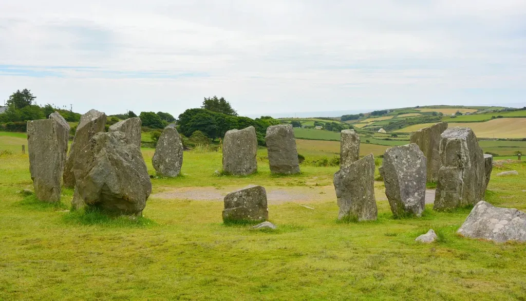
#15 – The Cochno Stone’s Cryptic Carvings
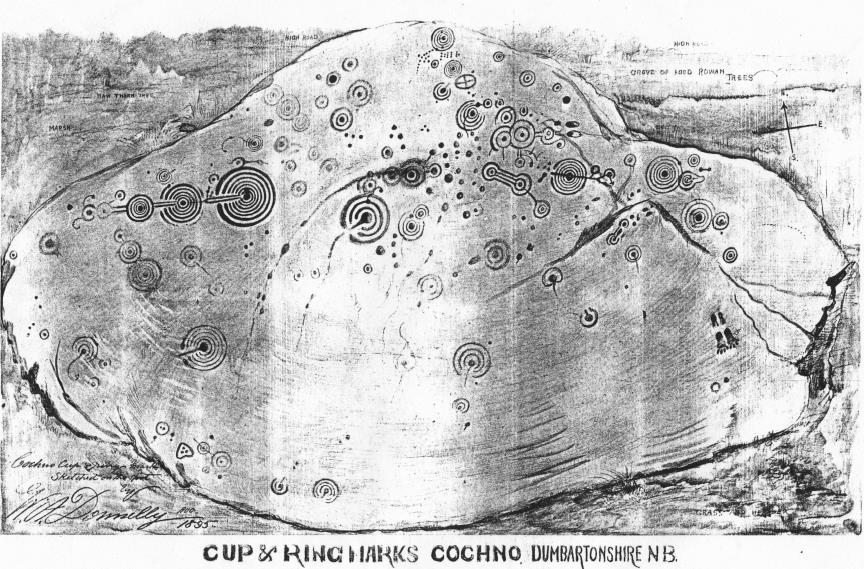
Buried under a Scottish field for decades specifically to protect it, the Cochno Stone is one of the most elaborately decorated Neolithic slabs ever found in Britain. The 5,000-year-old sandstone surface is covered in dozens of cup-and-ring marks, spirals, and interconnected geometric motifs that researchers have studied since its rediscovery in the early 20th century – without reaching consensus on what any of it means. Some read it as a map, others as an astronomical calendar, and still others see purely ritual imagery tied to ceremonies we can no longer reconstruct.
Recent laser scanning revealed faint details invisible to the naked eye, including additional markings that had gone unnoticed for generations. Rather than clarifying the picture, those hidden details made the puzzle bigger. No comparable artifact from the same period in Neolithic Britain matches its scale or density of carving, which means there’s no reference point for comparison. Territorial marker, ceremonial surface, sacred geography – every theory explains some features and fails to account for others.
At a Glance
- Age: Approximately 5,000 years old (Neolithic period)
- Location: Clydebank, West Dunbartonshire, Scotland
- Surface: Large sandstone slab covered in cup-and-ring marks, spirals, and geometric motifs
- Status: Reburied for protection; studied via 3D laser scanning and photogrammetry
- Competing theories: Star map, astronomical calendar, ritual surface, territorial marker
#14 – The Klerksdorp Spheres’ Impossible Precision
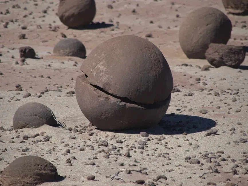
South African miners have been pulling small, grooved metallic spheres out of Precambrian rock for decades – rock dated at over 2 billion years old. The spheres are hard, uniformly shaped, and marked with parallel grooves that run around their circumferences with a consistency that looks, at first glance, deeply unnatural. They’ve become a favorite of ancient-civilization theorists, who argue no geological process could produce that kind of symmetry without intent behind it.
Mainstream geology attributes them to a natural concretion process, where minerals accumulate around a nucleus over vast time scales. That explanation is scientifically credible, but it hasn’t fully silenced the debate – because the evenness of the grooves and the hardness of the material remain genuinely unusual compared to other known concretions. No ancient intelligence is required to explain them, but the fact that geologists still field serious questions about them decades after their discovery says something about how strange they actually look in person.
#13 – The Yonaguni Monument’s Underwater Steps
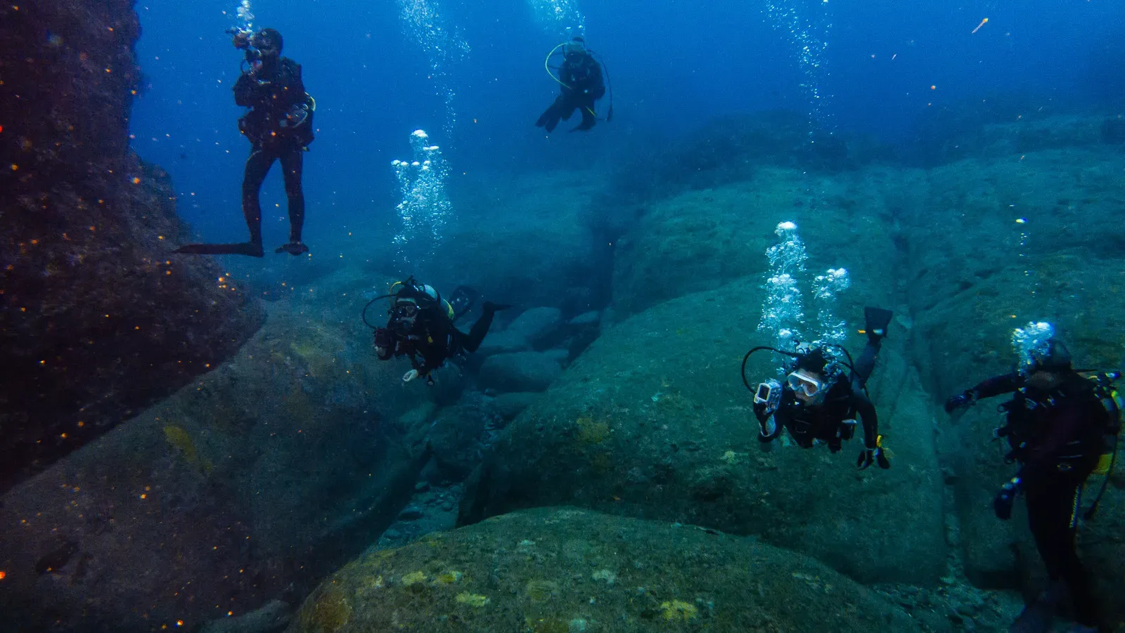
Off the southwestern tip of Japan’s Yonaguni Island, about 25 meters below the surface, divers encounter a massive stone formation that stops most of them cold. It has broad flat terraces, sharp right-angle corners, aligned channels, and what appear to be staircase-like steps cut into solid rock. Japanese researchers have mapped the site extensively, identifying what they describe as a ceremonial plaza, carved pillars, and a main platform structure spanning hundreds of meters. If it’s man-made, it was likely above water around 10,000 years ago when sea levels were significantly lower.
Geologists who favor a natural explanation point to the layered sandstone’s tendency to fracture along clean planes, arguing that wave action over millennia could produce the angular shapes without any human hand involved. The problem is that right-angle corners and aligned features at this scale are extraordinarily rare in purely natural formations – and the sheer extent of the geometry makes the coincidence argument harder to sustain. No tools or artifacts have been found at the site, so the debate remains unresolved, suspended somewhere between geology and archaeology with neither side fully winning.
#12 – The Paracas Candelabra’s Unknown Makers
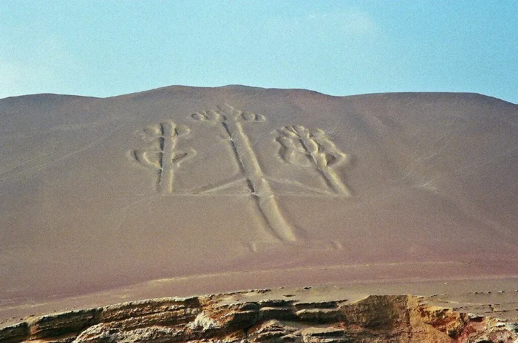
Carved into a hillside above Peru’s Paracas Bay, visible from miles out at sea, the Candelabra geoglyph stretches nearly 600 feet from base to tip. Unlike the Nazca Lines further inland, it was etched into a steep coastal slope rather than a flat desert plain, which raises its own engineering questions. Pottery fragments near the site date to around 200 BCE, but that only gives a rough window – not a definitive origin culture or confirmed purpose. Proposals range from a navigational beacon for ancient sailors to a religious symbol tied to the trident staff of a deity, and neither theory holds up cleanly under scrutiny.
What makes the Candelabra particularly strange is that erosion studies suggest it may be significantly older than the associated pottery, meaning a later culture may have simply used a site they inherited rather than created. Aerial surveys have revealed additional faint lines in the surrounding hillside, hinting at a larger system of markings that have mostly been worn away. The engineering precision – those clean, consistent trenches cut into unstable coastal hillside – required deliberate effort and clear planning. Whatever the intent was, somebody wanted this seen from far away, and they built it to last.
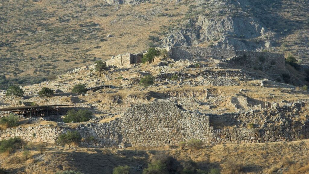
#11 – Derinkuyu’s Massive Underground City
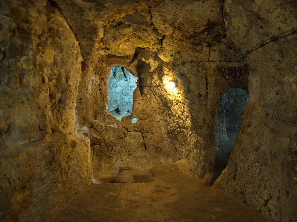
Eighteen stories beneath the plains of central Turkey, someone carved an entire city out of solid volcanic rock. Derinkuyu isn’t just a series of tunnels – it had ventilation shafts engineered to reach the surface, rooms designated for livestock, storage areas, wine presses, schools, and living quarters capable of sheltering an estimated 20,000 people. The oldest sections date to at least the 8th century BCE, though some researchers believe the initial excavation began even earlier. The sheer logistical intelligence required – managing airflow, preventing collapse, organizing vertical living across 18 levels – still impresses modern mining engineers who examine it.
What no one can explain is who started it, or why they went so deep when surface fortifications were the more common defensive strategy across the ancient world. Later inhabitants, including early Christian communities fleeing persecution, clearly expanded and used the city – but they didn’t build the foundations. The original planners left no inscriptions, no obvious cultural artifacts, no named identity. They dug down nearly 85 meters into the earth, built something extraordinary, and then vanished from the historical record entirely.
Fast Facts
- Depth: Approximately 85 meters (280 feet) below the surface
- Capacity: Estimated to shelter up to 20,000 people and their livestock
- Levels: At least 18 known floors; researchers believe more may remain undiscovered
- Defense: Massive circular stone doors weighing 200–500 kg, operable only from inside
- Infrastructure: Ventilation shafts, water wells fed by an underground river, wine presses, stables, and a church
- Connected to: A believed 9-km tunnel linking it to the nearby Kaymaklı Underground City
#10 – Roopkund Lake’s Frozen Skeletons

At roughly 16,500 feet in the Indian Himalayas, there is a small glacial lake whose shores are scattered with hundreds of human skeletons. They were first reported by a British forest ranger in 1942 and have puzzled researchers ever since. Radiocarbon dating places most of the deaths around the 9th century CE, and the majority of the skulls show identical blunt-force trauma – rounded depressions consistent with being struck from above by something spherical. Many researchers concluded a sudden catastrophic hailstorm killed a large group of pilgrims, which fits the injury pattern but leaves open serious questions about how so many people ended up in this specific remote location at the same time.
The deeper mystery emerged from DNA analysis published in Nature Communications in 2019, which revealed the dead were not a single group. Genome-wide analysis of 38 skeletons found three genetically distinct clusters: 23 individuals with South Asian ancestry dating to around 800 CE, 14 with ancestry typical of the eastern Mediterranean dating to around 1800 CE, and one individual with Southeast Asian-related ancestry. These groups appear to have died in separate events roughly a thousand years apart, not in a single catastrophe. How Mediterranean people ended up dead on a remote Himalayan lakeshore, and why the lake keeps accumulating bodies across different eras, is a question that genetic science raised more sharply than it answered.
Worth Knowing
- Altitude: Over 5,000 meters (16,500 ft) above sea level in the Indian Himalayas
- Skeletons: Several hundred individuals of unknown origin scattered around the lakeshore
- DNA findings: Three genetically distinct groups identified – South Asian, eastern Mediterranean, and Southeast Asian
- Not one event: Radiocarbon dating confirms deaths occurred in multiple episodes separated by roughly 1,000 years
- Cause of death: Skull trauma consistent with large, rounded hailstones – but this applies only to one group
- Key question: Researchers still cannot explain what brought eastern Mediterranean individuals to this remote Himalayan site
#9 – Lascaux Cave Paintings’ Hidden Symbolism
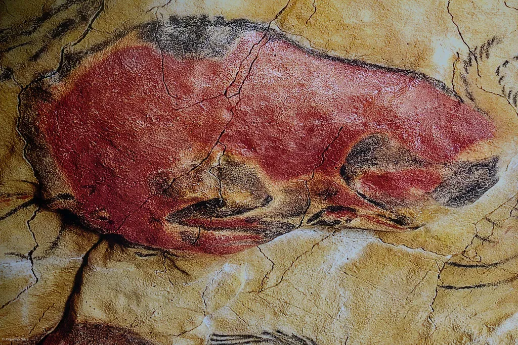
Seventeen thousand years ago, in a cave system in the Dordogne region of France, artists worked by firelight to paint horses, bulls, and deer with a technical sophistication that genuinely shocks modern viewers. The proportions are accurate, the movement is captured, the shading is deliberate. They used scaffolding to reach high ceilings, mixed natural pigments with binding agents, and planned compositions across entire walls. More than 600 painted figures and 1,500 engravings fill the chambers – making Lascaux not a single inspired moment but an ongoing artistic project sustained over generations.
But scattered among the animals are abstract symbols – grids, dots, lines, and geometric shapes – that appear in specific chambers in ways that suggest intentional placement rather than random decoration. The infamous “bird-man” figure in the Shaft of the Dead Man, a humanoid with a bird’s head lying near a wounded bison, has generated more competing interpretations than almost any other prehistoric image on earth. Shamanic transformation, hunting ritual, narrative mythology – every reading is plausible and none is provable. The cave is now closed to the public to prevent further deterioration, which means the symbols will keep their secrets behind a locked door indefinitely.
#8 – Venus Figurines’ Cultural Network
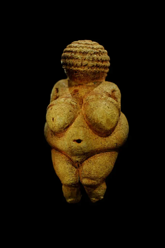
From Spain to Siberia, carved female figurines dating between 30,000 and 10,000 years ago follow a pattern so consistent it’s genuinely difficult to explain. Exaggerated hips, prominent breasts, rounded belly – and almost universally, no face. Over 200 examples have been found across an enormous geographic range, carved from ivory, bone, limestone, and fired clay by cultures that had no obvious means of direct contact with each other. Whatever these objects meant, the shared visual language implies something far more connected than isolated tribes carving in the dark.
The leading theories – fertility symbols, goddess worship, self-portraits by pregnant women – each capture part of the picture and miss the rest. The deliberate omission of faces is one of the most persistent puzzles: these weren’t failed attempts at portraiture, because the carving skill required to create the body detail was clearly available to the artists. Something specific was being communicated through the facelessness, and we don’t know what. Many figurines were found in everyday settlement debris rather than graves or obvious ritual spaces, which means they may have been objects of daily significance rather than purely ceremonial ones – a detail that complicates every interpretation built around sacred use.
Quick Compare
- Timespan: 30,000–10,000 years ago (Upper Paleolithic)
- Geographic range: Spain to Siberia – roughly 6,000 miles
- Count: Over 200 examples documented across Europe and western Asia
- Materials used: Mammoth ivory, bone, limestone, soapstone, fired clay
- Shared trait: Deliberately no face – across all cultures, all materials, all regions
- Where found: Mostly everyday settlement debris, not graves or dedicated ritual sites
#7 – Sacsayhuamán’s Precision Stonework
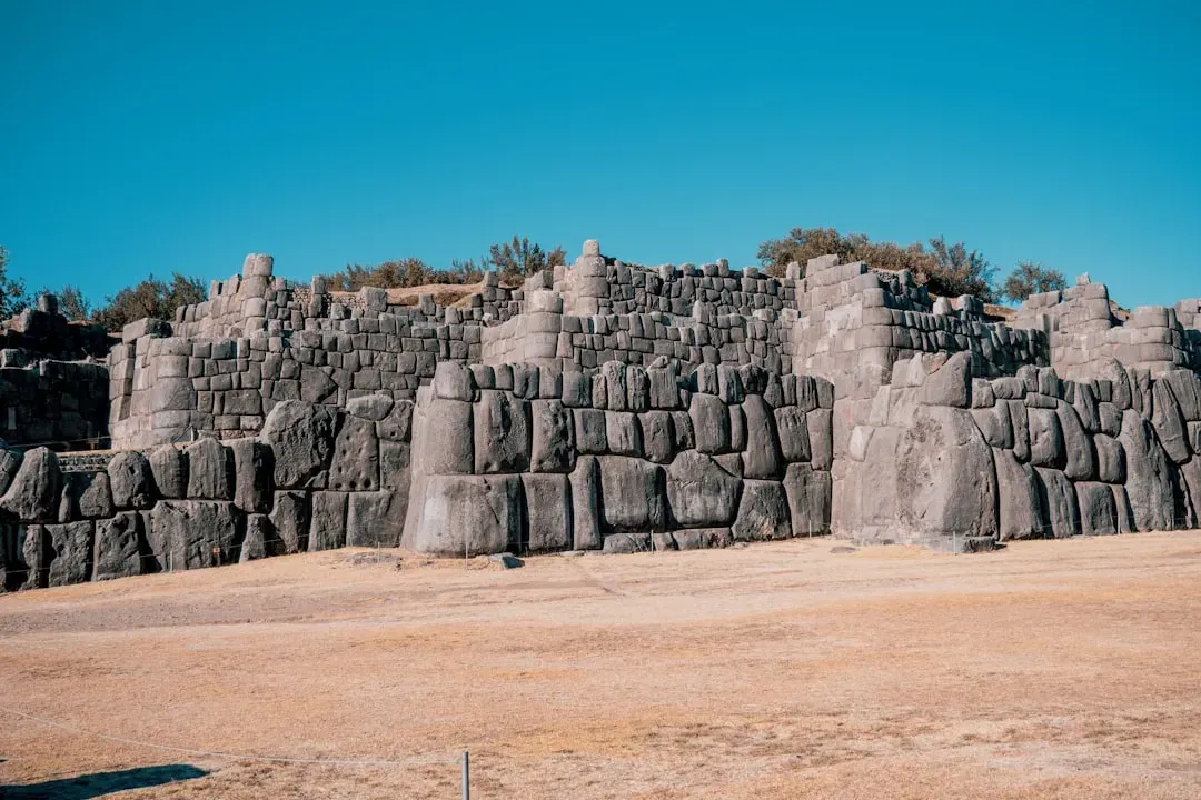
The walls of Sacsayhuamán above Cusco, Peru, are built from stones so carefully fitted together that a knife blade cannot be slipped between them. Some of those stones weigh over 200 tons. They were quarried miles away, transported across difficult terrain, and then shaped – without iron tools, without wheeled vehicles, without draft animals capable of moving that kind of load – into irregular polygonal forms that interlock with their neighbors at precise angles. The result is a wall system so seismically resistant that it survived earthquakes that destroyed Spanish colonial buildings constructed centuries later right next to it.
Modern engineers and archaeologists have run experiments with ropes, ramps, levers, and large teams of workers, and while those methods can theoretically move the stones, no experiment has yet replicated the fitting precision at the same scale. The Inca kept oral records of many construction achievements but left nothing that fully explains the organizational system behind Sacsayhuamán’s largest blocks. Local traditions credit supernatural forces, which archaeologists dismiss – while simultaneously acknowledging that the conventional explanation still has a gap where the most critical technical details should be.
#6 – The True Cause of Neanderthal Disappearance
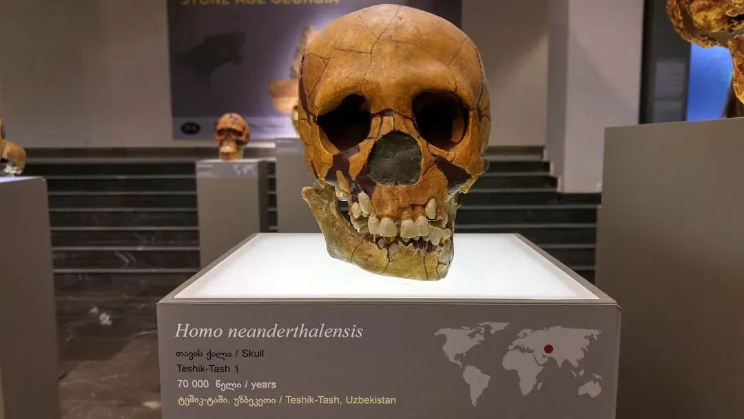
Neanderthals lived across Europe and western Asia for roughly 300,000 years. They buried their dead, created pigments, used tools, and – as genetic evidence now conclusively shows – interbred with modern humans. Then, around 40,000 years ago, they vanished as a distinct population with a speed that the archaeological record still hasn’t fully explained. Climate change, competition for resources, introduced diseases, and direct conflict have all been proposed and studied seriously. None of them, alone or in combination, produces a model that accounts for everything the fossil and genetic record shows.
What makes the disappearance stranger is the evidence of how close the two groups actually were. Neanderthal DNA persists in the genomes of most non-African humans today at levels between 1 and 2 percent – a trace of real, sustained interbreeding across generations. Tool assemblages from the transition period show overlap and possible cultural exchange. These weren’t two groups that never touched; they lived alongside each other for thousands of years. What ultimately tipped the balance toward the complete disappearance of one group remains, after decades of increasingly sophisticated analysis, genuinely unresolved.
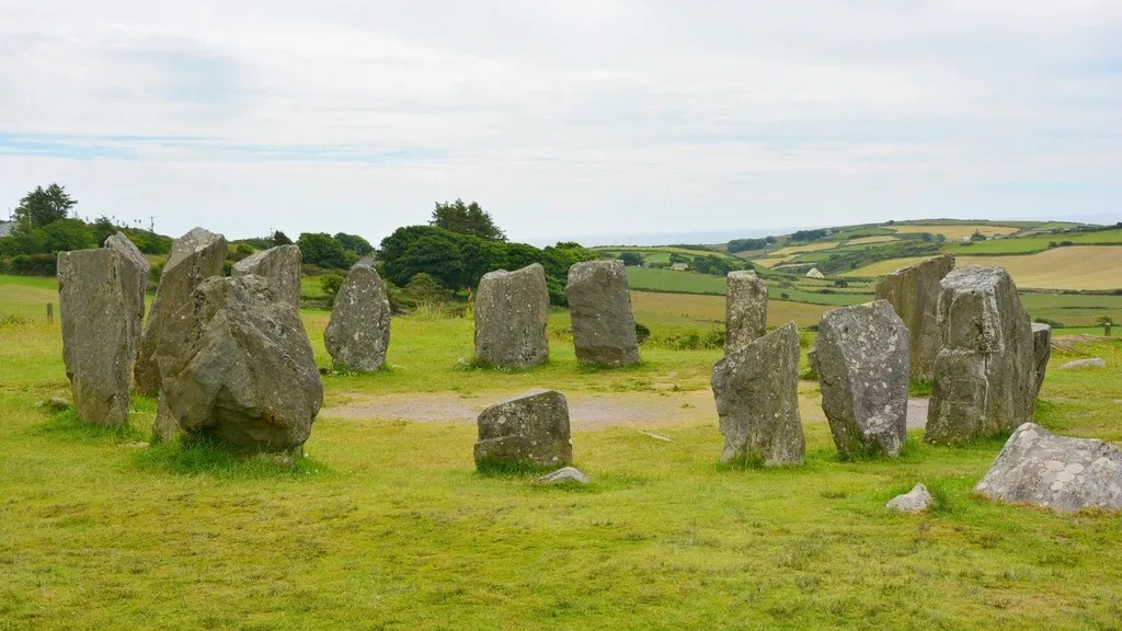
#5 – Ram Setu’s Ancient Causeway
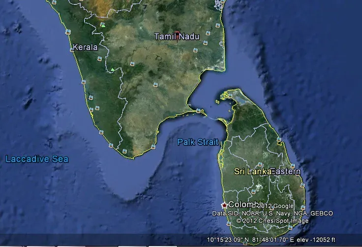
Between the southeastern tip of India and the northwestern coast of Sri Lanka, a chain of limestone shoals stretches for 48 kilometers in a formation linear enough to be unmistakable in satellite imagery. Hindu tradition identifies it as the bridge described in the Ramayana, built by an army of divine beings to retrieve the abducted Sita. Geological surveys have dated the formation to somewhere between 7,000 and 18,000 years ago, placing it within a period when sea levels were low enough that it may have stood above water as a natural land bridge.
What keeps the mystery alive scientifically is the unusual uniformity of the ridge – its consistent width and its alignment with tidal flow patterns – which some researchers argue suggests possible human modification of a natural feature rather than purely geological formation. Coral and sediment studies confirm it was once exposed above the waterline, but no artifacts have been recovered from the submerged ridge to confirm deliberate construction. Political and religious sensitivities in the region have repeatedly blocked the kind of systematic underwater archaeological survey that might settle the question, leaving it suspended between mythology and geology with neither domain able to claim a definitive answer.
#4 – The Osirion’s Anachronistic Design
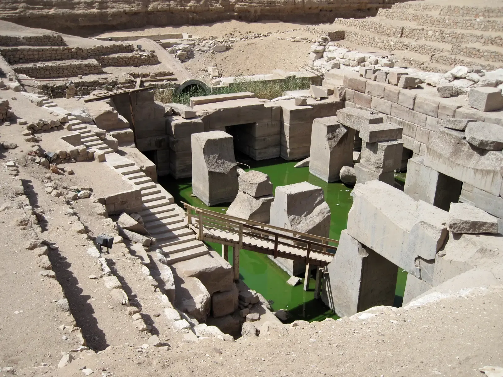
Behind the temple of Seti I at Abydos, Egypt, sits a structure that doesn’t fit. The Osirion is built from massive granite blocks with a subterranean layout, surrounded by a water channel and organized around a central island. Its construction style – the sheer scale of the undecorated granite blocks, the precision of the joinery, the architectural logic – looks far more like Old Kingdom work from the pyramid age than anything from the New Kingdom period when Seti I ruled around 1300 BCE. Egyptologists who study it regularly describe it as anomalous, meaning it breaks the pattern of everything built around it.
The working theory is that Seti I built it as a deliberate archaism, intentionally imitating an older style to evoke antiquity and sacred authority. That’s plausible – but it doesn’t explain why the masonry technique isn’t merely stylistically similar to Old Kingdom work but is, in the judgment of many researchers, essentially identical in quality and method to structures built more than a thousand years earlier. Ongoing excavation has uncovered additional architectural anomalies beneath the main structure without resolving the timeline. Whether the Osirion was built on far older foundations, or whether New Kingdom craftsmen simply executed a perfect historical imitation, remains one of Egyptology’s quietly persistent debates.
#3 – The Nazca Lines’ Ritual Purpose
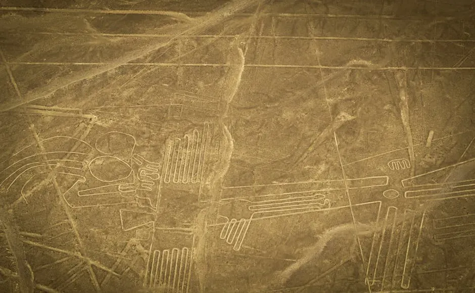
Between 500 BCE and 500 CE, the Nazca people of southern Peru created something that only makes full sense from the air – hundreds of geometric lines, spirals, and enormous animal figures etched into the desert by removing the dark surface pebbles to reveal lighter ground beneath. A 1,200-foot hummingbird. A spider. A monkey with a coiled tail. Over 800 straight lines and 300 figures spread across 500 square kilometers of desert plateau, preserved for millennia by one of the driest and most windless climates on earth. The scale and precision of the figures, created by a culture without aircraft, is staggering.
The astronomy theory – that the lines track stellar or solar alignments – held sway for decades but has been largely abandoned by mainstream researchers because the alignments aren’t consistent or predictive enough to function as a calendar. The most compelling recent evidence comes from drone surveys that identified alignments between many of the lines and underground water sources and aquifers. In a desert culture where water was life, marking the invisible pathways of water across the landscape with massive sacred drawings makes a different kind of sense. And the full picture keeps expanding: between September 2022 and February 2023, AI-assisted field surveys confirmed 303 previously unknown geoglyphs – nearly doubling the known catalog of figurative figures – including a 72-foot-long orca wielding a knife and abstract humanoid forms that had gone undetected for decades.
Why It Stands Out
- Scale: Over 800 straight lines and 300+ figures across 500 sq km of desert
- Preservation: Survived 2,000+ years due to one of Earth’s driest, most windless climates
- New discoveries: 303 new geoglyphs confirmed by AI-assisted surveys in 2022–2023, increasing the known catalog by ~40%
- Strangest find: A 72-foot orca figure holding a knife – undiscovered until AI analysis
- Leading theory: Alignments with underground aquifers suggest sacred water-marking in an extreme desert environment
- Still expanding: Only 26% of AI-flagged candidate sites have been investigated on the ground
#2 – Stonehenge’s Multifaceted Function
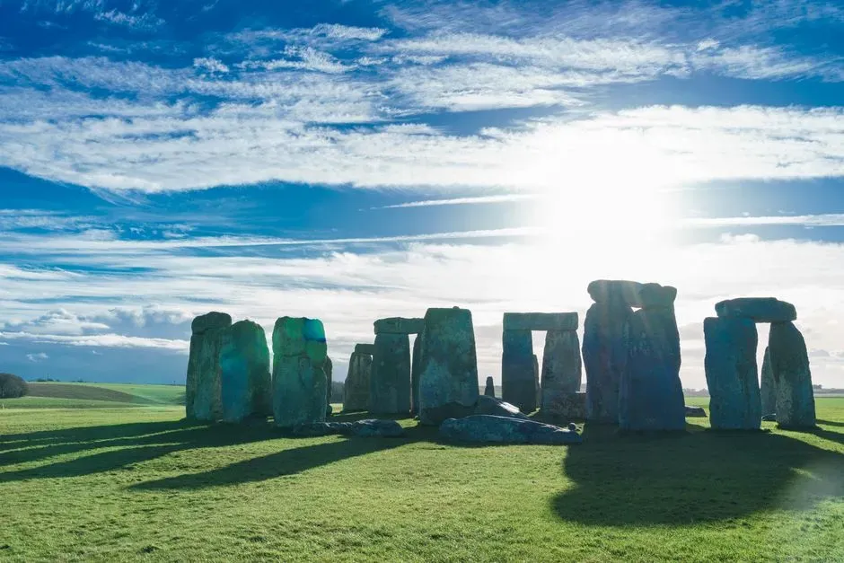
Stonehenge is so familiar that it’s easy to forget how strange it actually is. Construction began around 3000 BCE and continued in phases for more than a thousand years – meaning no single generation built it, and no single generation knew what it would become. The bluestones in the inner circle were transported from the Preseli Hills in Wales, roughly 140 miles away, across terrain that makes the logistics nightmarish even to modern engineers. The larger sarsen stones came from Marlborough Downs, 20 miles away, and some weigh over 25 tons. Generations of workers coordinated across centuries toward a design that evolved as it was built.
Recent isotope analysis of cremated human remains found at the site revealed individuals who had spent their lives far from Wiltshire – from Wales, Scotland, and elsewhere across Britain. Stonehenge wasn’t just a local monument; it was a destination, drawing people from across the island for purposes that included burial, ceremony, and possibly healing. The solar alignments at the solstices are precise and undisputed. But the full sequence of how and why the monument evolved across a millennium, why it was eventually abandoned, and what the experience of being there during its active use actually felt like – those questions remain stubbornly open, resistant to even the most sophisticated non-invasive research tools available today.
#1 – Göbekli Tepe’s Revolutionary Implications
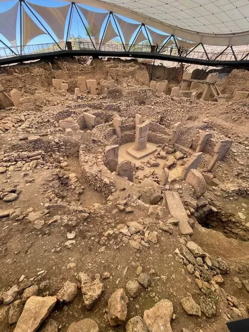
In 1994, on a hilltop in southeastern Turkey, archaeologist Klaus Schmidt recognized something that would rewrite the timeline of human civilization: an 11,000-year-old complex of carved stone pillars arranged in circular enclosures, built by hunter-gatherers who, by every assumption archaeologists had made, shouldn’t have been capable of organizing anything at this scale. The T-shaped limestone monoliths stand up to 18 feet tall and are decorated with detailed carvings of foxes, snakes, scorpions, vultures, and abstract symbols. The people who built them had no metal tools, no pottery, no domesticated animals, and no agriculture. They built it anyway.
What Göbekli Tepe dismantled wasn’t just a date on a timeline – it was a foundational assumption about what drives civilization. The old model said agriculture came first, then settlement, then the surplus and organization that allowed monuments. Göbekli Tepe says the opposite may be true: that the drive to build something monumental and sacred may have come first, and agriculture emerged to feed the people gathered to do it. Around 8000 BCE, the entire complex was deliberately buried – filled in with rubble, as if intentionally preserved or ritually closed. Excavations have since revealed even older layers beneath the main structures, and researchers estimate that roughly 15 more enclosures remain buried underground – with one possibly dating to 13,000 BCE. Today, only about 10% of the site has been excavated, and experts suggest completing the work could take another 150 years. The site keeps going deeper, and with each new layer, the question of where organized human symbolic culture actually began gets pushed further back into time we thought we understood.
Fast Facts
- Age: Oldest known structures date to approximately 10,000–11,000 BCE; some layers may reach 13,000 BCE
- Pillar weight: Individual T-shaped limestone pillars weigh up to 20 tons
- Builders: Hunter-gatherers with no pottery, no metal tools, and no confirmed agriculture
- Excavated so far: Roughly 10% of the total site
- Still buried: An estimated 15 additional enclosures remain underground
- 2024 discovery: A human statue with clearly defined head and torso features was unearthed between two main enclosures
- Predates Stonehenge by: At least 6,000 years
We used to think that civilization gave rise to religion. Göbekli Tepe suggests it may have been the other way around.
Klaus Schmidt, archaeologist and lead excavator of Göbekli Tepe
These Mysteries Aren’t Going Away – And That’s the Point
What connects all fifteen of these mysteries isn’t the fringe speculation they’ve attracted – it’s the serious scientific discomfort they produce. Göbekli Tepe and Stonehenge have forced genuine revisions to how archaeologists sequence the emergence of complex society. The Nazca Lines and Venus figurines expose how poorly we understand the interior symbolic lives of the people who made them. Neanderthal disappearance and Roopkund Lake remind us that even events with physical evidence left behind can remain stubbornly resistant to full explanation.
The uncomfortable truth these sites share is that prehistoric humans were doing things we can observe but not fully decode – building, carving, gathering, grieving, and believing in ways that left marks in stone and bone that have outlasted every explanation we’ve tried to give them. That’s not a failure of archaeology. That’s what it looks like when a discipline is honest about the limits of what physical evidence can tell us about human meaning. The mysteries that resist the longest tend to be the ones that matter most.